Related Plugins and Tags

QGIS Planet

Plugin Update Sept-Nov 2023

This autumn, from September to November, 84 new plugins have been published in the QGIS plugin repository.

Here’s the quick overview in reverse chronological order. If any of the names or short descriptions piques your interest, you can find the direct link to the plugin page in the table below:

SOSIexpressions
Expressions related to SOSI-data
Puentes
Run external Python files inside QGIS.
UA CRS Magic
Підбір системи кординат для векторного шару
FilterMate
FilterMate is a Qgis plugin, a daily companion that allows you to easily explore, filter and export vector data
QWC2_Tools
QGIS plug-in designed to publish and manage the publication of projects in a QWC2 instance. The plugin allows you to publish projects, delete projects and view the list of published projects.
QGIS Fast Grid Inspection (FGI)
This plugin aims to allow the generation and classification of samples from predefined regions.
QDuckDB
This plugin adds a new data prodivder that can read DuckDB databases and display their tables as a layer in QGIS.
CIGeoE Toggle Label Visibility
Toggle label visibility
CIGeoE Merge Areas
Centro de Informação Geoespacial do Exército
Drainage
the hydro DEM analysis with the TauDEM
Postcode Finder
The plugin prompts the user to select the LLPG data layer from the Layers Panel and enter a postcode. The plugin will search for the postcode, if found, the canvas will zoom to all the LLPG points in the postcode.
Multi Union
This plugin runs the UNION MULTIPLE tool, allowing you to use up to 6 polygon vector layers simultaneously.
FLO-2D MapCrafter
This plugin creates maps from FLO-2D output files.
Download raster GEE
download_raster_gee
GisCarta
Manage your GisCarta data
TENGUNGUN
To list up and download point cloud data such as “VIRTUAL SHIZUOKA”
LADM COL UV
Plugin de Qgis para la evaluación de calidad en el proceso de captura y mantenimiento de datos conformes con el modelo LADM-COL
ohsomeTools
ohsome API, spatial and temporal OSM requests for QGIS
Social Burden Calculator
This plugin calculates social burden
Show Random Changelog Entry on Launch
Shows a random entry in the QGIS version’s visual changelog upon QGIS launch
Fotowoltaika LP
Wyznaczanie lokalizacji pod farmy fotowoltaiczne LP
KICa – KAN Imagery Catalog
KICa, is QGIS plugin Kan Imagery Catalog, developed by Kan Territory & IT to consult availability of images in an area in an agnostic way, having as main objective to solve the need and not to focus on suppliers. In the beginning, satellite imagery providers (free and commercial) are incorporated, but it is planned to incorporate drone imagery among others.
Risk Assessment
Risk assessment calculation for forecast based financing
ViewDrone
A QGIS plugin for viewshed analysis in drone mission planning
qgis2opengis
Make Lite version of OpenGIS – open source webgis
Quick Shape Update
Automatic update of the shapes length and/or area in the selected layer
CoolParksTool
This plugin evaluates the cooling effect of a park and its impact on buildings energy and thermal comfort
Nahlížení do KN
Unofficial integration for Nahlížení do Katastru nemovitostí.
PyGeoRS
PyGeoRS is a dynamic QGIS plugin designed to streamline and enhance your remote sensing workflow within the QGIS environment.
D4C Plugin
This plugin allows the manbipulation from QGis of Data4Citizen datasets (Open Data platform based on Drupal and CKan)
Avenza Maps’s KML/KMZ File Importer
This plugin import features from KML e KMZ files from Avenza Maps
Histogram Matching
Image histogram matching process
PV Prospector
Displays the PV installation potential for residential properties. The pv_area layer is derived from 1m LIDAR DSM, OSMM building outlines and LLPG data.
Save Attributes (Processing)
This plugin adds an algorithm to save attributes of selected layer as a CSV file
Artificial Intelligence Forecasting Remote Sensing
This plugin allows time series forecasting using deep learning models.
Salvar Pontos TXT
Esse plugin salvar camada de pontos em arquivo TXT
QGIS to Illustrator with PlugX
The plugin to convert QGIS maps to import from Illustrator. With PlugiX-QGIS, you can transfer maps designed in QGIS to Illustrator!
QCrocoFlow
A QGIS plugin to manage CROCO projectsqcrocoflow
Soft Queries
This plugin brings tools that allow processing of data using fuzzy set theory and possibility theory.
TerrainZones
This Plugin Identifies & Creates Sub-Irrigation Zones
Consolidate Networks
Consolidate Networks is a a Qgis plugin bringing together a set of tools to consolidate your network data.
AWD
Automatic waterfalls detector
SAGis XPlanung
Plugin zur XPlanung-konformen Erfassung und Verwaltung von Bauleitplänen
Monitask
a SAM (facebook segment anything model and its decendants) based geographic information extraction tool just by interactive click on remote sensing image, as well as an efficient geospatial labeling tool.
PLATEAU QGIS Plugin
Import the PLATEAU 3D City Models (CityGML) used in Japan — PLATEAU 3D都市モデルのCityGMLファイルをQGISに読み込みます
FLO-2D Rasterizor
A plugin to rasterize general FLO-2D output files.
Geoportal Lokalizator
PL: Wtyczka otwiera rządowy geoportal w tej samej lokacji w której użytkownik ma otwarty canvas QGIS-a. EN: The plugin opens the government geoportal in the same location where the user has the QGIS canvas open (Poland only).
BorderFocus
clicks on the edge center them on the canvas
LANDFILL SITE SELECTION
Bearing & Distance
This plugin contains tools for the calculation of bearing and distances for both single and multiple parcels.
Moisture and Water Index 2.0
Este complemento calcula el índice NDWI con las imágenes del Landsat 8.
K-L8Slice
Este nombre combina el algoritmo k-means que se utiliza para el agrupamiento (K) con “Landsat 8”, que es el tipo específico de imágenes satelitales utilizadas, y “Slicer”, que hace referencia al proceso de segmentación o corte de la imagen en diferentes clusters o grupos de uso del suelo.
EcoVisioL8
Este complemento fue diseñado para automatizar y optimizar la obtención de índices SAVI, NDVI y SIPI, así como la realización de correcciones atmosféricas en imágenes Landsat 8.
QGIS Animation Workbench
A plugin to let you build animations in QGIS
Catastro con Historia
Herramienta para visualizar el WMS de Catastro en pantalla partida con historia.
RechercheCommune
Déplace la vue sur l’emprise de la commune choisie.
Sentinel2 SoloBand
Sentinel2 SoloBand is a plugin for easily searching for individual bands in Sentinel-2 imagery.
CIGeoE Right Angled Symbol Rotation
Right Angled Symbol Rotation
CIGeoE Node Tool
Tool to perform operations over nodes of a selected feature, not provided by similar tools and plugins.
Spatial Distribution Pattern
This plugin estimates the Spatial Distribution Pattern of point and linear features.
Webmap Utilities
This plugin provides tools for clustered and hierarchical visualization of vector layers, creation of Relief Shading and management of scales using zoom levels.
Simstock QGIS
Allows urban building energy models to be created and simulated within QGIS
Fast Point Inspection
Fast Point Inspection is a QGIS plugin that streamlines the process of classifying point geometries in a layer.
Layer Grid View
The Layer Grid Plugin provides an intuitive dockable widget that presents a grid of map canvases.
Kadastr.Live Toolbar
Пошук ділянки на карті Kadastr.Live за кадастровим номером.
S+HydPower
Plugin designed to estimate hydropower generation.
QollabEO
Collaborative functions for interaction with remote users.
digitizer
digitizer
NetADS
NetADS est un logiciel web destiné à l’instruction dématérialisée des dossiers d’urbanisme.
Runoff Model: RORB
Build a RORB control vector from a catchment
FlexGIS
Manage your FlexGIS data
LXExportDistrict
Export administrative district
PostGIS Toolbox
Plugin for QGIS implementing selected PostGIS functions
Chasse – Gestion des lots
Fonctions permettant de définir la surface cadastrale des lots de chasse et d’extraire la liste des parcelles concernées par chaque lot de chasse, sous forme de fichier Excel®.
Time Editor
Used to facilitate the editing of features with lifespan information
RST
This plugin computes biophysical indices
Japanese Grid Mesh
Create common grid squares used in Japan. 日本で使われている「標準地域メッシュ」および「国土基本図図郭」を作成できます。また、国勢調査や経済センサスなどの「地域メッシュ統計」のCSVファイルを読み込むこともできます。プロセッシングツールボックスから利用できます。
Panoramax
Upload, load and display your immersive views hosted on a Panoramax instance.
StereoPhoto
Permet la visualisation d’images avec un système stéréoscopique
CIGeoE Merge Multiple Lines
Merge multiple lines by coincident vertices and with the same attribute names and values.
CIGeoE Merge Lines
Merge 2 lines that overlap (connected in a vertex) and have same attribute names and values.
Nimbo’s Earth Basemaps
Nimbo’s Earth Basemaps is an innovative Earth observation service providing cloud-free, homogenous mosaics of the world’s entire landmass as captured by satellite imagery, updated every month.
OpenHLZ
An Open-source HLZ Identification Processing Plugin
Selection as Filter
This plugin makes filter for the selected features

Plugin Update August 2023

In August 13 new plugins that have been published in the QGIS plugin repository.

Here’s the quick overview in reverse chronological order. If any of the names or short descriptions piques your interest, you can find the direct link to the plugin page in the table below the screenshot.

Cesium ion
Browse and add datasets from Cesium ion
Land Use Analyzer
A plugin for Land Use spatial analysis tools
GNAVS
GNSS Navigate and Save
Soar – the new atlas
Import or export maps via the Soar platform
FotovolCAT
Spatial analysis automation for solar power station sitting in Catalonia
QGISSPARQL-Layer2Triple
Layer2Triple
osm2topomap
A plugin intended to intermediate the process of using OSM data for official (authoritative) Topographc Maps, or rather, databases
Plugin Exporter
A QGIS plugin for exporting plugins
GetBaseLine
GetBaseLine
Fast Field Filler
The plugin was created to quickly fill in the fields in the attribute table.
Radiation ToolBox Plugin
Plugin for loading data from Safecast and other radiation monitoring devices
LocationIQ Geocoding and Maps
LocationIQ integration to add geocoding and map tiles to QGIS
Proxy Handler
Adds prefix proxy addresses to connections

Plugin Update June & July 2023

In this summer plugin update, we explore 51 new plugins that have been published in the QGIS plugin repository.

Here’s the quick overview in reverse chronological order. If any of the names or short descriptions piques your interest, you can find the direct link to the plugin page in the table below the screenshot.

JAPATI
The QGIS plugin is used by agencies in the West Java provincial government to upload data and create map services on the geoserver in order to publish data internally and publicly
BD TOPO® Extractor
This tool allows you to extract specific data from IGN’s BD TOPO®. The extraction is based on either an extent drawned by the user on the map canvas or a layer’s extent.
Opacity Set
Sets opacity 0.5, 0.75 or 1 for selected raster layer.
USM toolset (Urban Sprawl Metric toolset)
The USM Toolset was developed to facilitate the calculation of Weighted Urban Proliferation (WUP) and all components of urban sprawl for landscapes that include built-up areas (e.g., dispersion (DIS), land uptake per person (LUP).
DAI
DAI (Daily Aerial Image)
France Commune Cadastre
Search for a cadastral parcel with the French cadastre API
Two distances intersection
Get the intersection of two distances (2D cartesian)
IDG
Plugin providing easy access to data from different SDI
SPAN
SPAN is a flexible and easy to use open-source plugin based on the QGIS software for rooftop mounted PV potential estimation capable of estimating every roof surface’s PV potential.
CSV Batch Import
Batch import of CSV vector layers
Imagine Sustainability
sustainability assessment tool based on geographic MCDA algorithms. Especially suitable for Natura 2000 sites, based on pyrepo-mcda package(https://pyrepo-mcda.readthedocs.io/)
QGIS Hub Plugin
A QGIS plugin to fetch resources from the QGIS Hub
VFK Plugin
Data českého katastru nemovitostí (VFK)<br><br>Czech cadastre data (VFK)
LinearReferencing
Tools for linear referenced data
CIGeoE Circumvent Polygon
Changes the line to circumvent a polygon between the intersection points
UA XML importer
Імпортує геометрію ділянки, обмежень, угідь та територіальних зон з кадастрового обмінного файлу XML
eagris
QGIS eAGRI plugin
Geojson Filling
Allows to fill imported geojson layers with pre-defined field values
Save All
File saving script that saves qgis project file and all vector and raster layers into user-specified folder. Automatically detects file type and saves as that file type (supports SHP, GPKG, KML, CSV, and TIF). All styles and formatting are saved with each layer (except for KML), ensuring that they are opened up with the proper style the next time the project is opened. Temporary layers are made permanent automatically.
Fast Density Analysis
A fast kernel density visualization plugin for geospatial analytics
StreetSmart
This plugin manages the Street Smart imagery
FilePath
Copies the path of layer
pandapower QGis Plugin
Plugin to work with pandapower or pandapipes networks
Eqip
Qgis Pip Management
Infra-O plugin
Plugin for Finnish municipal asset management.
Add to Felt
Create a collaborative Felt (felt.com) map from QGIS
Lahar Flow Map Tools
This plugin is for opening and processing results from LaharFlow
Station Offset
This plugin computes the station and offset of points along polylines and exports those values to csv for other applications
Jilin1Tiles
Jilin1Tiles
SiweiEarth
This plugin is used to load the daily new map provided by Siwei Earth.
QdrawEVT
Easily draw and select entities in the drawing footprint. Installation of the plugin “Memory layer saver” highly recommended. See Read_me.txt file in the Help folder of the plugin. Dessiner et selectionner facilement les entités dans l’emprise du dessin. Installation du plugin “Memory layer saver” fortement recommandé. Voir fichier Lisez_moi dans le dossier Hepl du plugin. Merci !
Fuzzy Logic Toolbox
This plugin implements the fuzzy inference system
feature_space
A plugin to plot feature space and export areas as raster or vector
Panorama Viewer
Plugin for QGIS to view 360-degrees panoramic photos
Map Segmenter
Uses machine learning to segment a map into ares of interest.
ALKIS Plugin
Das Plugin verfügt über zwei Werkzeugkästen und insgesamt vier einfache Werkzeuge. Im Werkzeugkasten “Gebäude” finden Sie drei nützliche Werkzeuge, um ALKIS-Gebäudedaten aufzubereiten. Sie können Dachüberstände erstellen, Gebäude auf der Erdoberfläche extrahieren und redundante Gebäudeteile eliminieren. Im Werkzeugkasten “Nutzung” steht Ihnen ein weiteres Werkzeug zur Verfügung, mit dem Sie die Objektarten in den Objektartengruppen Vegetation, Siedlung, Verkehr und Gewässer zuordnen können. Das Plugin erfordert als Datengrundlage ALKIS-Daten im vereinfachten Format, die in NRW, Deutschland, frei verfügbar sind. Dieses Plugin wurde zu Demonstrationszwecken entwickelt. Das Ziel besteht darin, in einer Videoreihe die Entwicklung eines Plugins ohne die Anwendung von Python vorzustellen. Die Tutorials dazu findet ihr in der folgenden Playlist: https://www.youtube.com/playlist?list=PLq5L9pOv_ur5wRAVHt3iVw61mUUpb54aJ
isobenefit
Isobenefit Urbanism plugin for QGIS.
UA_MBD_TOOLS
Tools for
Qpositional
assessment the positional quality of geographic data
Terraform
Implementation of popular topographic correction algorithms and various methods of their evaluation.
PathoGAME
The goal is to find the location of the contamination as soon as possible.
Azure Maps Creator
Provides access to Azure Maps Creator services
CIGeoE Identify Dangles
Identifies dangles in a viewport
Delete Duplicate Fields
Delete duplicate or redundant fields from a vector file
LocationFinder
Allow QGIS to use LocationFinder (interactive geocoding)
COA TPW Polygonizer
This plugin can be used to create polygons that track the shape of a line network, including the proper handling of intersections with common nodes of the line segments.
XPlan-Umring
Create XPlanGML from polygon(s)
Tweet my river
AI Tweet classifier for river layers
3DCityDB Tools
Tools to visualize and manipulate CityGML data stored in the 3D City Database
GroundTruther
A toolset for Seafloor Caracterization
Faunalia Toolkit
Cartographic and spatial awesome analysis tool and much much more!

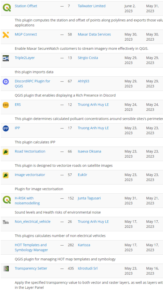
Plugin Update May 2023

In May 22 new plugins that have been published in the QGIS plugin repository.

Here’s the quick overview in reverse chronological order. If any of the names or short descriptions piques your interest, you can find the direct link to the plugin page in the table below the screenshot.

Station Offset
This plugin computes the station and offset of points along polylines and exports those values to csv for other applications
MGP Connect
Enable Maxar SecureWatch customers to stream imagery more effectively in QGIS.
Triple2Layer
this plugin imports data
DiscordRPC Plugin for QGIS
QGIS plugin that enables displaying a Rich Presence in Discord
ERS
This plugin determines calculated polluant concentrations around sensible sites’s perimeters
IPP
This plugin calculates IPP
Road Vectorisation
This plugin is designed to vectorize roads on satellite images
Image vectorisator
Plugin for image vectorisation
H-RISK with noisemodelling
Sound levels and Health risks of environmental noise
Non_electrical_vehicle
This plugins calculates number of non electrical vehicles
HOT Templates and Symbology Manager
QGIS plugin for managing HOT map templates and symbology
Transparency Setter
Apply the specified transparency value to both vector and raster layers, as well as layers within the selected groups in the Layer Panel
DBGI
Creates geopackages that match the requirements for the DBGI project
StyleLoadSave
Load or Save active vector layer style
PixelCalculator
Interactively calculate the mean value of selected pixels of a raster layer.
GISTDA sphere basemap
A plugin for adding base map layers from GISTDA sphere platform (https://sphere.gistda.or.th/).
Adjust Style
Adjust the style of a map with a few clicks instead of altering every single symbol (and symbol layer) for many layers, categories or a number of label rules. A quick way to adjust the symbology of all layers (or selected layers) consistantly, to check out how different colors / stroke widths / fonts work for a project, and to save and load styles of all layers – or even to apply styles to another project. With one click, it allows to: adjust color of all symbols (including color ramps and any number of symbol layers) and labels using the HSV color model (rotate hue, change saturation and value); change line thickness (i.e. stroke width of all symbols / symbol borders); change font size of all labels; replace a font family used in labels with another font family; save / load the styles of all layers at once into/from a given folder.
APLS
This plugin performs Average Path Length Similarity
qaequilibrae
Transportation modeling toolbox for QGIS
QGPT Agent
QGPT Agent is LLM Assistant that uses openai GPT model to automate QGIS processes
FuzzyJoinTables
Join tables using min Damerau-Levenshtein distance
Chandrayaan-2 IIRS
Generates reflectance from Radiance data of Imaging Infrared Spectrometer sensor of Chandrayaan 2

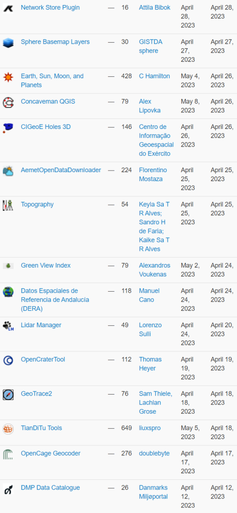
Plugin Update April 2023

April wasn’t just the month of our wonderful user conference and contributor meeting, it was also a month with a whopping 23 new plugins that have been published in the QGIS plugin repository.

Here’s the quick overview in reverse chronological order. If any of the names or short descriptions piques your interest, you can find the direct link to the plugin page in the table below the screenshot.

Network Store Plugin
export layers to kisters network store
Sphere Basemap Layers
This plugin let you to add a variety of thailand basemap from GISTDA sphere Open Platform
Earth, Sun, Moon, and Planets
Tools to calculate the positions of the sun, moon, and planets when viewed from directly overhead for a particular date and time. It displays solar and lunar information for a coordinate at the specified date and time. (Note the Python library dependencies.)
Concaveman QGIS
Makes concave hull for points
CIGeoE Holes 3D
Draws holes in polygons (3D)
AemetOpenDataDownloader
This Plugin download open data from aemet
Topography
The plugin is available in this first version with the functionality to calculate closed polygons using the projections method.
Green View Index
A plugin for Green View Index (GVI) operations
Datos Espaciales de Referencia de Andalucía (DERA)
Loading of wfs/wms services from DERA Spatial Reference Data.Carga de los servicios wfs/wms de los Datos Espaciales de Referencia DERA
Lidar Manager
Manage LiDAR (dtm/dsm) dataset from Tile Index Layer
OpenCraterTool
A tool to measure and compare craters
GeoTrace2
A QGIS plugin for geological mapping
TianDiTu Tools
天地图底图加载
OpenCage Geocoder
Geocoding using the OpenCage API
DMP Data Catalogue
Discover and add layers from the Danish Miljøportal data catalog
File Management
Plugin to help with file management from the Layers Panel.
Bestagon
Form (mostly Hexagon) generator for point intensities
Indiana Ortho Imagery
This plugin provide easy access to Indiana Ortho Imageries
Adresssuche
Searching for an adresspoint in Germany based on offical data – ALKIS Adresssuche
GpuDataChecker
Plugin pour l’aide au contrôle de la validité géométrique de données pour intégration dans le géoportail de l’urbanisme
Tile Index Generator
This plugin creates tile index in vector format for XYZ tiles.
SeaLevelTool
Adjust styling on raster layer by a sea level curve.
DataSud
Plugin pour QGIS 3 fournissant un accès simple aux flux de données géographiques (WMS, WFS) publiées par la Région Sud sur DataSud.fr.

Plugin Update February & March 2023

So February came and went without us sharing our monthly plugin update. That means, this post lists a whopping 32 new plugins that have been published in the QGIS plugin repository in February and March.

Here’s the quick overview in reverse chronological order. If any of the names or short descriptions piques your interest, you can find the direct link to the plugin page in the table below the screenshot.

BPEJ a RÚIAN pro SWAT
Plugin stahuje a upravuje data BPEJ a upravuje data RÚIAN pro model SWAT
PyQGIS Resource Browser
A Qt resource browser right into QGIS.
Austria Weather API
QGis connection to Geosphere Austria API
DataSud
Plugin pour QGIS 3 fournissant un accès simple aux flux de géographiques WMS et WFS des données OpenStreetMap publiées sur DataSud pour la Région Provence-Alpes-Côte-d’Azur.
CIGeoE Converge Lines
Creates a point of convergence of lines within a selected area.
Delete all
QGIS plugin to delete all groups and layers from the layers widget
CPR
CPR (Colour Pattern Regression)
Remote DB Plugin
Manage and open SSH connections to remote database servers
MOJXML Loader
This plugin is made for Japanese users. It converts Japanese “MOJ Map XML” (land registration polygon data) into geospatial formats. 法務省登記所備付地図データ(地図XML)の変換や読み込みを行います。
Custom TitleBar
Configure what is displayed in the title bar (QGIS full version, sha, project name, …)
ScienceFlightPlanner
This plugin helps to create scientific flight plans.
LRS-Editor
Editor for Linear Referencing Systems
CRS Guesser
Guesses unknown CRS for layers
Extractor
Extractor allows for the extraction of data from raster images based on point, line, and polygon vectors and the application of zonal statistics. Its usefulness lies in its ability to work with a range of raster sources, making it ideal for time series analysis and landscape studies.
Coverage Builder
Create rectangles to use as an input layer for atlas generation.
Gamepad Navigation
Navigate 2D and 3D map canvases using gamepad controllers (Playstation, Xbox, PC, etc.)
Street Facing Side
Identifies the side of the polygon (e.g. parcels or building footprints) that is facing the street, river, or any other line vector file type. Outputs a new line feature for each polygon feature, based on what side of the polygon was identified as the ‘street-facing’ side. Requires both an input polygon layer and input line layer.
Dichtheitsprüfung Checker
With this plugin, the raw data from leak tests (.sew files) can be read and checked for content.
Limburg Flood Impact
Limburg Flood Impact Plugin.
Walidator plików GML
Walidacja i kontrola plików GML baz: BDOO, BDOT10k, PRNG, GESUT, EGiB, BDOT500
infas LT Geocoder
Geocoding with infas LT Geocoder
CRAIG
Plugin pour QGIS 3 fournissant un accès simple aux flux de données géographiques WMS/WMTS et WFS du CRAIG et d’autres ressources géographiques utiles en région Auvergne Rhône-Alpes.
Feature Nodes Z Tag
Tags the nodes of a feature with it’s Z value
QRestart
A plugin that allows users to restart the QGIS.
Sewerage Designer
The Sewerage Designer computes the required sizing and depth of a stormwater sewer system.
Check4SEC
Simulator of the Check4SEC validations in SEC and creation of GML file. (ES) Simulador del validador Check4SEC de la SEC y creación de fichero GML.
QChatGPT
A plugin integration between QGIS and openai API.
Reloader
Reload selected layer(s).
Plot grid tool
This plugin create a grid file from a plot boundary file
Indiana LiDAR
This plugin helps you access Indiana LiDAR data products.
Raster Volume Comparison
Calculates the difference in volume between two raster layers
Save_DXF
This plugin exports a laye to DXF file

Plugin Update January 2023

This month has been busy with 20 new plugins in the QGIS plugin repository.

Since it can be challenging to stay up to date, our monthly plugin update provides you a quick overview of the newest plugins. If any of the names or short descriptions piques your interest, you can find the direct link to the plugin page in the table below the screenshot.

ThreePointMethod
Determine the orientation of geological surfaces using the three-point vector method.
japanGeology3
japanGeology3
CartoDruid Synchronizer
Plugin to synchronize SQLite databases to Cartodruid Synchronization services at ITACyL
eTracability Automatic Accountability Tracker
This plugin adds automatic attributes to vector layers, that track who updated or created features, and when.
MINDED FBA
An automatic remote sensing tool for the estimation of flooded and burned areas.
QKan
Gruppe der QKan-Erweiterung(en)
MAGIC Map Loader
This plugin will open the DEFRA MAGIC Map service on the area of your map canvas
Full MCE for Public Health
Full Multicriteria Evaluation tool for Public Health
Lat lon buffer
This processing plugin makes a buffer in meters around lat lon point features
Equi Processing
Equidistance algorithme
Qpip
Qgis Pip Management
Geo-Zone Check Germany
UAS flight restriction checker for Germany
NIB-ortofoto-prosjekt
Henter alle ortofoto-prosjekt fra Norge i bilder (WMS) som ligger innafor et utsnitt.
Kauko työkalut
Kauko työkalut
Plan Creator 3
Tool for creating a digital building model Инструмент создания цифровой модели здания
Project Reports
Plugin to generate reports (CSV and HTML) of properties and metadata about layers, fields and layouts of QGIS projects.
Kartverket adresse-API
This plugin fetches coordinates for Norwegian addresses using the Kartverket open adress-API
SenseHawk QC
This plugin will load and save SenseHawk projects needing quality check.
Polygon from map extent
A lightweight QGIS plugin to make a polygon from the current map extent.
Equirectangular 360° Viewer
Equirectangular and 360° streetview like image viewer

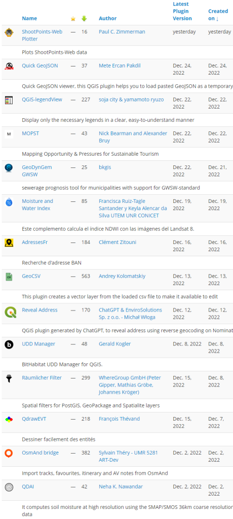
Plugin Update December 2022

The QGIS plugin repository currently lists 1752 plugins and the list keeps on growing. This month has been busy with 14 new plugins. It can be challenging to stay up to date.

Our monthly plugin update is meant to provide you a quick overview of the newest plugins. If any of the names or short descriptions piques your interest, you can find the direct link to the plugin page in the table below the screenshot.

ShootPoints-Web Plotter
Plots ShootPoints-Web data
Quick GeoJSON
Quick GeoJSON viewer, this QGIS plugin helps you to load pasted GeoJSON as a temporary (memory) layer.
QGIS-legendView
Display only the necessary legends in a clear, easy-to-understand manner
MOPST
Mapping Opportunity & Pressures for Sustainable Tourism
GeoDynGem GWSW
sewerage prognosis tool for municipalities with support for GWSW-standard
Moisture and Water Index
Este complemento calcula el índice NDWI con las imágenes del Landsat 8.
AdressesFr
Recherche d’adresse BAN
GeoCSV
This plugin creates a vector layer from the loaded csv file to make it available to edit
Reveal Address
QGIS plugin generated by ChatGPT, to reveal address using reverse geocoding on Nominatim API
UDD Manager
BitHabitat UDD Manager for QGIS.
Räumlicher Filter
Spatial filters for PostGIS, GeoPackage and Spatialite layers
QdrawEVT
Dessiner facilement des entités
OsmAnd bridge
Import tracks, favourites, itinerary and AV notes from OsmAnd
QDAI
It computes soil moisture at high resolution using the SMAP/SMOS 36km coarse resolution global soil moisture data

Plugin Update November 2022

The QGIS plugin repository currently lists 1739 plugins and the list keeps on growing. This month has been busy with 12 new plugins. It can be challenging to stay up to date.

Our monthly plugin update is meant to provide you a quick overview of the newest plugins. If any of the names or short descriptions piques your interest, you can find the direct link to the plugin page in the table below the screenshot.

BDOT10k
Wtyczka do pobierania danych BDOT10k. Plugin for downloading BDOT10k data.
DMI Open Data
This plugin lets you import data from DMIs Open Data
road2QGIS
Plugin faisant appel au calcul d’itinéraires du Géoportail pour intégration dans QGIS
NextGIS Points2One
Create lines and polygons from vertices.
Go Data Extraction
This is a Plugin for QGIS that enables users to log in to Go.Data and extract case data. Go.Data is an application which facilitates outbreak investigation, including field data collection, contact tracing, and visualization of chains of transmission.
LayerTree2JSON
Parse QGIS 3 project and write a JSON config file with layer information.
Tieosoitetyökalu
Tieosoitetyökalu-plugin hakee VKM-rajapinnasta osoitetietoja ja esittää niitä erilaisin tavoin QGIS:sissa.
Koordinates
Discover, view and clone Koordinates hosted data directly from QGIS.
GPS Replay
Allows replay of a previously logged GPS file (i.e. a NMEA text log).
Segment reshape tool
Tool to reshape toplogically connected segments
GBFS-NOW
GBFS-NOW
School placement multi-criteria decision analysis (MCDA)
This plugin generates a customized site classification raster layer for educational facilities (schools).

Plugin Update October 2022

The QGIS plugin repository currently lists 1728 plugins and the list keeps on growing. October has been busy with 15 new plugins. It can be challenging to stay up to date.

Our monthly plugin update is meant to provide you a quick overview of the newest plugins. If any of the names or short descriptions piques your interest, you can find the direct link to the plugin page in the table below the screenshot.

Query Tool
The plugin is used to extract clusters (Tie) on shapefile issue for the Pavemetrics inspections systems.
NextGIS IdentifyPlus
Extended identify tool. Show photos and other attachments stored in your Web GIS right in QGIS. Developed by NextGIS.
MapBiomas Collection Official
This plugin lets you add the anual land use and land cover maps from the MapBiomas Project (http://mapbiomas.org/) as a collection of WMS layer.
FLINTpro Datacheck
This plugin is designed for FLINTpro users to easily check the compatibility of data for uploading to FLINTpro.
Selection Sets Reloaded
Plugin for saving and loading selection sets for layers.
Deepness: Deep Neural Remote Sensing
Inference of deep neural network models (ONNX) for segmentation, detection and regression
Create points on arcs’ intersection
The plugin creates a new layer with points on arcs’ intersection within the same layer
Download data from IBGE
This plugin downloads data from IBGE
QGIS-GMSH
This is a plugin to interract with the GMSH mesh generator (see http://geuz.org/gmsh).
Replace Geometry
Replaces a geometry keeping the attributes unchanged
SensorThings API
The plugin enables QGIS to access dynamic data from sensors, using SensorThings API protocol (https://www.ogc.org/standards/sensorthings)
Fast Field Filler
The plugin was created to quickly fill in the fields in the attribute table.
Nearest Neighbor Method for Linear Features (NNMLF)
This plugin estimates the spatial distribution pattern of linear features.
NDFF Connector Plugin
This connector uses the NDFF-Connector library to create all needed configuration and settings to connect to the NDFF api, to upload Observations/Waarnemingen
Zone Label
This plugin allows to split and manually label rectangular areas.

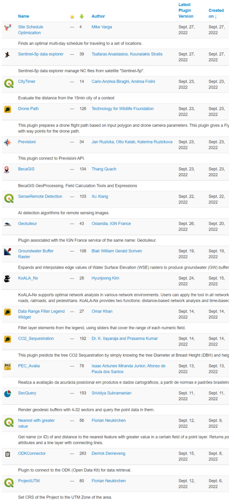
Plugin Update September 2022

The QGIS plugin repository currently lists 1710 plugins and the list keeps on growing. September has been busy with 16 new plugins. It can be challenging to stay up to date.

Our monthly plugin update is meant to provide you a quick overview of the newest plugins. If any of the names or short descriptions piques your interest, you can find the direct link to the plugin page in the table below the screenshot.

Site Schedule Optimization
Finds an optimal multi-day schedule for traveling to a set of locations.
Sentinel-5p data explorer
Sentinel-5p data explorer manage NC files from satellite “Sentinel-5p”.
CityTimer
Evaluate the distance from the 15min city of a context
Drone Path
This plugin prepares a drone flight path based on input polygon and drone camera parameters. This plugin gives a Fly Litchi compatible csv file with way points for the drone path.
Previsioni
This plugin connect to Previsioni API.
BecaGIS
BecaGIS GeoProcessing, Field Calculation Tools and Expressions
SenseRemote Detection
AI detection algorithms for remote sensing images.
Geotuileur
Plugin associated with the IGN France service of the same name: Geotuileur.
Groundwater Buffer Raster
Expands and interpolates edge values of Water Surface Elevation (WSE) rasters to produce groundwater (GW) buffer rasters
KoALA_Nx
KoALA-Nx supports optimal network analysis in various network environments. Users can apply the tool in all network environments, such as roads, railroads, and pedestrians. KoALA-Nx provides two functions: distance-based network analysis and time-based network analysis
Data Range Filter Legend Widget
Filter layer elements from the legend, using sliders that cover the range of each numeric field.
CO2_Sequestration
This plugin predicts the tree CO2 Sequestration by simply knowing the tree Diameter at Breast Height (DBH) and height of the tree.
PEC_Avalia
Realiza a avaliação da acurácia posicional em produtos e dados cartográficos, a partir de normas e padrões brasileiros
SecQuery
Render geodesic buffers with 4-32 sectors and query the point data in them.
Nearest with greater value
Get name (or ID) of and distance to the nearest feature with greater value in a certain field of a point layer. Returns point layer with added attributes and a line layer with connecting lines.
ODKConnector
Plugin to connect to the ODK (Open Data Kit) for data retrieval.

Plugin Update August 2022

The QGIS plugin repository currently lists 1694 plugins and the list keeps on growing, even during the holiday season. It can be challenging to stay up to date.

Our new monthly plugin update is meant to provide you a quick overview of the newest plugins. If any of the names or short descriptions piques your interest, you can find the direct link to the plugin page in the table below the screenshot.

STL Generator
This plugin lets you generate an STL from a DEM and allows the exclusion of nodata regions.
Maxent Model
Maxent mapping adapter for QGIS. Adaptador de cartografía Maxent para QGIS
SRApp
Synchronizacja z bazą danych aplikacji Metryka
QGIS Redistricting
Tool for drawing districting plans from geographic units
XPlan-Reader
Import XPlan-GML
GEO_search
Layer Geo Search
Check, Define & Convert CRS
Check, define and convert CRS
Dynamic Provider Filter Plugin
QGIS plugin to dynamically set provider filters using QGIS variable replacement.
TopoTijdreis
This plugin loads all historic maps from 1815-2020 from topotijdreis.nl into QGIS
Tanaka Contours
Generates Tanaka-contours from a DEM

  • Page 1 of 1 ( 12 posts )
  • plugin update

Back to Top

Sustaining Members