Related Plugins and Tags

QGIS Planet

QGIS Grants #9: Call for Grant Proposals 2024

Dear QGIS Community,

We are very pleased to announce that this year’s round of grants is now available. The call is open to anybody who wants to make a contribution to QGIS funded by our grant fund, subject to the call conditions outlined in the application form.

The deadline for this round is in four weeks, on 14 March 2024.

There are no new procedures in 2024. Please note the following guidelines established in previous years: 

  • The proposal must be submitted as a ‘QEP’ (QGIS Enhancement Proposal) issue in the repo: https://github.com/qgis/QGIS-Enhancement-Proposals (tagged as Grant-2024). Following this approach will allow people to ask questions and provide public feedback on individual proposals.
  • Proposals must clearly define the expected final result so that we can properly assess if the goal of the proposal has been reached.
  • The project budgets should account for PR reviewing expenses to ensure timely handling of the project-related PRs and avoid delays caused by relying on reviewer volunteer time. 
  • In the week after the QEP discussion period, the proposal authors are expected to write a short summary of the discussion that is suitable for use as a basis on which voting members make their decisions. 

The PSC of QGIS.ORG will examine the proposals and has veto power in case a proposal does not follow guidelines or is not in line with project priorities.

For more details, please read the introduction provided in the application form.

We look forward to seeing all your great ideas for improving QGIS!

QGIS Grant Programme 2023 Results

We are extremely pleased to announce the 4 winning proposals for our 2023 QGIS.ORG grant programme:

Funding for the programme was sourced by you, our project donors and sponsorsNote: For more context surrounding our grant programme, please see: QGIS Grants #8: Call for Grant Proposals 2023.

The QGIS.ORG Grant Programme aims to support work from our community that would typically not be funded by client/contractor agreements. This means that we did not accept proposals for the development of new features. Instead proposals focus on infrastructure improvements and polishing of existing features.

Voting to select the successful projects was carried out by our QGIS Voting Members. Each voting member was allowed to select up to 6 proposals. The full list of votes are available here (on the first sheet). The following sheets contain the calculations used to determine the winner (for full transparency). The table below summarizes the voting tallies for the proposals:

A couple of extra notes about the voting process:

  • Voting was carried out based on the technical merits of the proposals and the competency of the applicants to execute on these proposals.
  • No restrictions were in place in terms of how many proposals could be submitted per person / organization, or how many proposals could be awarded to each proposing person / organization.
  • Voting was ‘blind’ (voters could not see the existing votes that had been placed).

We received 35 votes from 20 community representatives and 15 user group representatives.

On behalf of the QGIS.ORG project, I would like to thank everyone who submitted proposals for this call!

QGIS Grants #8: Call for Grant Proposals 2023

Dear QGIS Community,

We are very pleased to announce that this year’s round of grants is now available. The call is open to anybody who wants to make a contribution to QGIS funded by our grant fund, subject to the call conditions outlined in the application form.

The deadline for this round is in four weeks, on 2nd May 2023.

There are no new procedures in 2023. Please note the following guidelines established in previous years: 

  • The proposal must be submitted as a ‘QEP’ (QGIS Enhancement Proposal) issue in the repo: https://github.com/qgis/QGIS-Enhancement-Proposals (tagged as Grant-YEAR). Following this approach will allow people to ask questions and provide public feedback on individual proposals.
  • Proposals must clearly define the expected final result so that we can properly assess if the goal of the proposal has been reached.
  • The project budgets should account for PR reviewing expenses to ensure timely handling of the project-related PRs and avoid delays caused by relying on reviewer volunteer time. 
  • In the week after the QEP discussion period, the proposal authors are expected to write a short summary of the discussion that is suitable for use as a basis on which voting members make their decisions. 

The PSC of QGIS.ORG will examine the proposals and has veto power in case a proposal does not follow guidelines or is not in line with project priorities.

For more details, please read the introduction provided in the application form.

We look forward to seeing all your great ideas for improving QGIS!

Reports from the winning grant proposals 2022

With the QGIS Grant Programme 2022, we were able to support four proposals that are aimed to improve the QGIS project, including software, infrastructure, and documentation. The following reports summarize the work performed in the proposals. 

  1. Support building QGIS application on Qt 6 (#243) – Report
    In addition to the original plan of porting the “gui” and “app” libraries to Qt 6, it was possible to complete also the “3d” and “server” libraries. We now are at a stage where the majority of QGIS builds and runs without any significant issues on Qt 6. The Github CI setup has been updated to also run the C++ tests for gui, app, server and 3d, and the majority of these have been fixed so that they pass on the Qt 6 builds too. In addition, some tests which were failing under Qt 6 revealed some real QGIS bugs which have been fixed in the process of this work. (So there’s a direct benefit for the existing Qt 5 builds too!).
  2. Add SQL Logging in the debugging/development panel (#242) – Report
    When debugging or developing a QGIS algorithm or a QGIS plugin and when investigating performances of a particular layer it is often useful to view the SQL commands that QGIS sends to the backend. The SQL logging was implemented for Postgres, GeoPackage, Spatialite and Oracle data providers. immagine
  3. QGIS setting registry follow-up (#245) – Report
    The work can mainly be seen here PR qgis/QGIS#51295 with the proposed approach to register settings in a hierarchical and organized way, without too much complexity in the API to actually use the settings.
    To have a clean approach, some keys have been renamed. There is a compatibility handling (both forward and backward). The GUI implementation will be worked on during the HF in NL this spring.
  4. Fix handling of provider default value clauses/Autogenerate/nextval(…) handling (#247) – Report
    The bulk of these changes landed in the QGIS 3.28 release. A quick way to demonstrate on of the issues fixed is: open a Geopackage file, start editing the layer, add some features to it, but don’t save the edits, then right click the edited layer and try to save it to a different file. On older QGIS releases you’ll be spammed with a number of error messages because we tried to write a string value of “Autogenerate” into a number field for all the newly created features. On QGIS 3.28 this all just works as expected, with no errors encountered.

Thank you to everyone who participated and made this round of grants a great success and thank you to all our sustaining members and donors who make this initiative possible!

QGIS Grant Programme 2022 Results

We are extremely pleased to announce the four funded proposals for our 2022 QGIS.ORG grant programme. Funding for the programme was sourced by you, our project donors and sponsorsNote: For more context surrounding our grant programme, please see: QGIS Grants #7: Call for Grant Proposals 2022

These are the proposals:

  1. Add SQL Logging to the debugging/development panel
  2. QGIS setting registry enhancement
  3. Fix handling of provider default value clauses/Autogenerate/nextval(…) handling
  4. Support building QGIS application on Qt 6

Since the total requested budget is equal to the available budget, there is no need for a voting this year.

On behalf of the QGIS.ORG project, I would like to thank everyone who submitted proposals for this call!

Reports from the winning grant proposals 2021

With the QGIS Grant Programme 2021, we were able to support eight proposals that are aimed to improve the QGIS project, including software, infrastructure, and documentation. The following reports summarize the work performed in the proposals. 

  1.  QGIS Server and services documentation (#213) – Report
    The Services chapter of the QGIS Server documentation needed some love to
    be effectively representative of the underlying implementation. Numerous
    services, requests or parameters were not documented at all. Some others
    also had very sketchy descriptions. Thanks to this QEP, the Services
    chapter is now in a much better shape!
  2. Rework handling of multi-layer, mixed-format datasets (#216) – Report
    While the work was partly motivated as an opportunity to clean up some
    older parts of the QGIS codebase which were fragile and had low test
    coverage, it has also resulted in many improvements and polish in the
    QGIS user interface.
  3. Port DB Manager Table Management Functionalities to Browser: SQL execution (part 3) (#205) – Report
    Besides SQL execution functionalities, an additional PR adds to QGIS core the query layer management tool that was provided by DB Manager plugin. The new API is fully covered by unit tests.
  4. Locale support for numeric input and display: revision and enhancements (#210) – Report
    The work has been completed with multiple pull requests that fixed all localization issues that have been reported plus countless unreported issues that have been identified along the way.
  5. Integrate GPS Tools plugin functionality into core QGIS (#217) – Report
    This grant sees the removal of the old, unmaintained “GPS Tools” core plugin, with all functionality from the plugin moved to reusable Processing algorithms or the unified Data Source Manager dialog. Since the functionality now uses the Processing framework, users gain the ability to run these tools in batch modes, as part of graphical models, and from 3rd party scripts and plugins. As a bonus the new tools are all fully covered by unit tests.
  6. QGIS Server, OGC tests and Continuous Integration: OGC API Features (part 2 (#212) – Report
    Thanks to the QEP funding, the OGC API Features standard for QGIS Server is
    now checked in QGIS continuous integration since end-November 2021.
  7. Fixing terrain and camera issues in 3D (#215) – Report
    These improvements should make the 3D map view easier to use. Especially the camera control issues (unintuitivie camera rotation and wrong center point) were quite tricky to fix.
  8. Review process on plugins.qgis.org and improvements (#219) – This proposal has been withdrawn.

Thank you to everyone who participated and made this round of grants a great success and thank you to all our sponsor and donors who make this initiative possible!

QGIS Grants #7: Call for Grant Proposals 2022

Dear QGIS Community,

We are very pleased to announce that this year’s round of grants is now available. The call is open to anybody who wants to make a funded contribution to QGIS, subject to the call conditions outlined in the application form.

The deadline for this round is in four weeks, on 13th February 2022.

As of 2022, we are changing the procedure in the following ways:

  • The project budgets should account for PR reviewing expenses to ensure timely handling of the project-related PRs and avoid delays caused by relying on reviewer volunteer time. 
  • In the week after the QEP discussion period, the proposal authors are expected to write a short summary of the discussion that is suitable for use as a basis on which voting members make their decisions. 

Also, note the following guidelines established in previous years: 

  • The proposal must be submitted as a ‘QEP’ (QGIS Enhancement Proposal) issue in the repo: https://github.com/qgis/QGIS-Enhancement-Proposals (tagged as Grant-YEAR). Following this approach will allow people to ask questions and provide public feedback on individual proposals.
  • Proposals must clearly define the expected final result, so that we can properly assess if the goal of the proposal has been reached.

For more details, please read the introduction provided in the application form.

We look forward to seeing all your great ideas for improving QGIS!

Reports from the winning grant proposals 2020

With the QGIS Grant Programme 2020, we were able to support ten proposals that were aimed to improve the QGIS project, including software, infrastructure, and documentation. The following reports summarize the work performed in the proposals. We’ll update this blog post as more reports come in:

  1. Quality Assurance methodology and infrastructure (Alexandre Neto, Alexander Bruy, Giovanni Manghi)

    The Tester plugin has been updated to run on QGIS 3.x. It allows to run automated and semi-automated tests and helps to conduct testing by providing step-by-step instructions to perform manual or verification tasks. An initial small set of tests for QGIS core functionality has been implemented as a separate QGIS Core Tests plugin. Furthermore, a test management system and test plan based on KIWI TCMS has been set up and documentation for testers has been created and published.

  2. Smarter map redraws + tile download manager (Martin Dobias)

    Smarter Map Redraws avoid the annoying flicker when map in the map canvas is zoomed or moved. It is especially noticeable with background maps. The work has reduced the problem especially for raster layers. See the videos of comparison before/after.
    Tile Download Manager is not going to be very visible to the users, but it should make QGIS behave nicely with remote servers – until now it would be common that QGIS would request raster/vector tiles, then abort the requests while they were in progress when map got moved/zoomed, only to start those requests again – this should be avoided now.

  3. DB Manager Table Management Functionalities to Browser Port – part 2 (Alessandro Pasotti)

    QGIS browser now exposes a new “Fields” item for vector layers that can be expanded to show the underlying fields, an icon identifies the base field type. New context menu items allow user to create and delete fields. At the connection level, a new context menu item allows you to create a new table for all DB connections that support the Connections API (PG, Spatialite, GPKG, MSSQL). All the new functions are implemented using the new connections API and exposed to Python for plugins/scripts. There have been many other small improvements in the API and in the browser, such as homogenization of the error/warning/success reporting .

  4. QGIS Server, OGC tests and Continuous Integration (Paul Blottiere)
    A Python tool named pyogctest has been implemented to run OGC tests in command line for the WMS 1.3.0 testsuite and has been integrated with GitHub Action in QGIS continuous integration mechanism to avoid regressions. The documentation chapter about OGC and conformance tests is now up-to-date with an explanation of how pyogctest can be used locally for server developers. Moreover, pyogctest is now also integrated with QGIS-Server-CertifSuite for the nightly tests. This way we have an homogeneous testing environment with CI. 
  5. QGIS Server performance monitoring (Paul Blottiere)
    The whole QGIS-Server-PerfSuite has been upgraded to use 3.10 and 3.14 releases side by side with 2.18 and master branch. Performances may be now monitored daily with the latest releases. Moreover, a simple anomalies detection mechanism has been implemented and a mail is sent if a regression is detected. Several scenarios have been added to compare performance with the same data but relying on different providers (PostGIS, Spatialite, Geopackage and Shapefile). Finally, a simple mechanism based on multiprocessing has been implemented to simulate multi-clients situation. 
  6. FileGeodatabase spatial index in OpenFileGDB driver (Even Rouault)
    This work has been successfully completed in GDAL master (for GDAL 3.2) and automatically benefits QGIS when it uses the OpenFileGDB driver. Performance-wise, for example, counting the number of features intersecting a spatial filter which returns 81 046 polygons, now runs in 400 ms with GDAL 3.2dev and the OpenFileGDB driver, versus 6.7 s before (full scan), vs 890 ms with the FileGDB driver (with FileGDB SDK 1.5). Interactive display in QGIS with the OpenFileGDB driver is as fluid as with the FileGDB one. Comparing behaviour of OpenFileGDB and FileGDB drivers with strace shows that they read a similar amount of data in the .spx file, which confirms it is uses correctly. The filegdb reverse engineered specification was also updated.
  7. MacOS packages (Peter Petrik)
    All tasks from the proposal except the notarization process have been addressed since the work necessary to address critical bugs in projection, grass, saga, gdal, python and other parts of the MacOS packages exceeded expectations. (A note about the workaround for notarization has been added to the QGIS.org webpage for now.) Key improvements for QGIS 3.16 MacOS Packages are: QGIS-Mac-Packager without homebrew dependencies, updated GDAL3, PROJ6 & GRASS 7.8.2, fixed Grass, Saga &, GDAL provider loading, and many more. 
  8. Evaluate Qt for Python (Denis Rouzaud)
    The initial evaluation was followed by a report on the migration to Qt-for-Python. The report’s recommendations are now being discussed in QEP#237.
  9. Settings registry (Denis Rouzaud)
    The complete implementation of the core part has been achieved (settings, registry and Python bindings). All core settings were migrated. Other settings still have to be migrated, CI tests should be added to avoid usage of the old API and potential GUI improvements are outlined in the report.
  10. To be continued 

Thank you to everyone who participated and made this round of grants a great success and thank you to all our sponsor and donors who make this initiative possible!

QGIS Grant Programme 2021 Results

We are extremely pleased to announce the 8 winning proposals for our 2021 QGIS.ORG grant programme. Funding for the programme was sourced by you, our project donors and sponsorsNote: For more context surrounding our grant programme, please see: QGIS Grants #6: Call for Grant Proposals 2021.

The QGIS.ORG Grant Programme aims to support work from our community that would typically not be funded by client/contractor agreements. This means that we did not accept proposals for the development of new features. Instead proposals focus on infrastructure improvements and polishing of existing features.

Voting to select the successful projects was carried out by our QGIS Voting Members. Each voting member was allowed to select up to 6 proposals. The full list of votes are available here (on the first sheet). The following sheets contain the calculations used to determine the winner (for full transparency). The table below summarizes the voting tallies for the proposals:

qgis-grants-2021

A couple of extra notes about the voting process:

  • Voting was carried out based on the technical merits of the proposals and the competency of the applicants to execute on these proposals.
  • No restrictions were in place in terms of how many proposals could be submitted per person / organization, or how many proposals could be awarded to each proposing person / organization.
  • Voting was ‘blind’ (voters could not see the existing votes that had been placed).

We received 39 votes from 23 community representatives and 16 user group representatives.

On behalf of the QGIS.ORG project, I would like to thank everyone who submitted proposals for this call!

QGIS Grants #6: Call for Grant Proposals 2021

Dear QGIS Community,

We are very pleased to announce that this year’s round of grants is now available. The call is open to anybody who wants to make a funded contribution to QGIS, subject to the call conditions outlined in the application form.

The deadline for this round is 21st March 2021.

For more details, please read the introduction provided in the application form.

We look forward to seeing all your great ideas for improving QGIS!

QGIS Grant Programme 2020 Results

We are extremely pleased to announce the winning proposals for our 2020 QGIS.ORG grant programme. Funding for the programme was sourced by you, our project donors and sponsorsNote: For more context surrounding our grant programme, please see: QGIS Grants #5: Call for Grant Proposals 2020.

The QGIS.ORG Grant Programme aims to support work from our community that would typically not be funded by client/contractor agreements. This means that we did not accept proposals for the development of new features. Instead proposals focus on infrastructure improvements and polishing of existing features.

Two proposals focusing on documentation improvements were funded directly from the documentation budget. The remaining 10 proposals continued on to the voting.

Voting to select the successful projects was carried out by our QGIS Voting Members. Each voting member was allowed to select up to 6 proposals. The full list of votes are available here (on the first sheet). The following sheets contain the calculations used to determine the winner (for full transparency). The table below summarizes the voting tallies for the proposals:

Thanks to the generous support by our sponsors and donors, we are happy that all proposals will receive funding, even if QEP#124 had to be reduced in scope (core part only, no GUI: €2,600 from QGIS grants & €1,400 sponsored by OPENGIS).

A couple of extra notes about the voting process:

  • Voting was carried out based on the technical merits of the proposals and the competency of the applicants to execute on these proposals.
  • No restrictions were in place in terms of how many proposals could be submitted per person / organization, or how many proposals could be awarded to each proposing person / organization.
  • Voting was ‘blind’ (voters could not see the existing votes that had been placed).

We received 34 votes from 21 community representatives and 13 user group representatives.

On behalf of the QGIS.ORG project, I would like to thank everyone who submitted proposals for this call!

QGIS Grants #5: Call for Grant Proposals 2020

Dear QGIS Community,

Our previous rounds of grant proposals have always been a great success (2019, 2018, 2017, 2016). We are very pleased to announce that this year’s round of grants is now available. The call is open to anybody who wants to make a funded contribution to QGIS, subject to the call conditions outlined in the application form.

The deadline for this round is 24th May 2020.

For more details, please read the introduction provided in the application form.

We look forward to seeing all your great ideas for improving QGIS!

Reports from the winning grant proposals 2019

With the QGIS Grant Programme 2019, we were able to support six proposals that were aimed to improve the QGIS project, including software, infrastructure, and documentation. These are the reports on the work that has been done within the individual projects:

  1. Profile and optimise the QGIS vector rendering code (Nyall Dawson)
    We conducted in-depth research into code “hot spots” and inefficiencies in the QGIS rendering code using a number of code profiling tools. This work resulted in many optimisations in the vector rendering code and other parts of QGIS (such as certain Processing algorithms). These optimisations were made available in the QGIS 3.10.0 release.
  2. “Rebalance” the labeling engine and fix poor automatic label placement choices (Nyall Dawson)
    We first designed unit tests covering a range of different label placement situations and then used these tests as a guide to re-work the label placement engine. Now, labels will never be placed over features from a layer with a higher obstacle weight, avoiding the complexities and bugs which were present in the older approach. To avoid disrupting existing projects, the new labeling logic is only used for newly created projects in QGIS 3.12 and later. (Existing projects can be upgraded via the project’s label settings dialog.)
  3. Reuse core functionality to provide DB manager features (Alessandro Pasotti & Nyall Dawson)
    We have developed a new QGIS core API, fully exposed to Python, that makes it possible to manage stored connections to various data provider source in a unified and consistent way. This is part of a larger effort building a new connections API.
  4. Snapping cache improvements (Hugo Mercier)
    Snapping is crucial for editing geospatial features. Snapping correctly supposes QGIS have in memory an indexed cache of the geometries to snap to. And maintainting this cache when data is modified, sometimes by another user or database logic, can be a real challenge. This it exactly what this work adresses. This feature has been merged into QGIS 3.12.
  5. Fix problems in larger 3D scenes (Martin Dobias)
    We worked on two issues within 3D map views. The first one was that map tiles were only being prepared using a single CPU core – this is now fixed and we may use multiple CPUs to load tiles of 3D scenes faster. The other (and greater) problem was that data from vector layers (when they have 3D renderer assigned) were all being prepared at once for the whole layer in the main thread. That resulted in possibly long freeze of the whole user interface while data were being loaded. This is now resolved as well and data from vector layers are being loaded in smaller tiles in background threads (and using multiple CPU cores). As a result, the overall user experience is now much smoother.
  6. Open documentation issues for pull requests (Matthias Kuhn and Denis Rouzaud)
    A documentation bot is now alive and automatically create an issue in the documentation repo for merged PR.

Thank you to everyone who participated and made this round of grants a great success and thank you to all our sponsor and donors who make this initiative possible!

Reports from the winning grant proposals 2018

With the QGIS Grant Programme 2018, we were able to support seven proposals that were aimed to improve the QGIS project, including software, infrastructure, and documentation. These are the reports on the work that has been done within the individual projects:

  1. Increased stability for Processing GUI and External Providers (Nyall Dawson)
    Many bugs in 3rd party providers have been fixed and lots of new unit tests added. The GUI includes new C++ classes and a  new framework that landed in QGIS 3.4. For more details see Nyall’s report on the mailing list.
  2. OSGeo4W updates (Jürgen Fischer)
    The updates performed in this project were essential to bring QGIS 3.x to Windows.
  3. Resurrect Processing “R” Provider (Nyall Dawson)
    The R provider has been implemented as a provider plugin. The plugin’s beta phase was first announced in Nov 2018 and the plugin is now available for general use.
  4. OpenCL support for processing core algs (Alessandro Pasotti)
    The following processing algorithms have been ported: slope, aspect, hillshade, and ruggedness. Even if was not in scope for this QEP, the hillshade renderer has also been optimized. For more details see qgis/QGIS#7451.
  5. QGIS server OGC compliant and certified for WFS (Régis Haubourg)
    This project fixed numerous issues to get closer to the goal of getting QGIS Server WFS certified. However, the project ran out of resources before the goal could be achieved. For details see the current WFS tests status page.
  6. Charts and drawings on attribute forms (Matthias Kuhn)
    For details read “The new QML widgets in QGIS” and see qgis/QGIS#7801.
  7. Update of QGIS Training Manual (Matteo Ghetta)
    This project hasn’t been completed yet.

Thank you to everyone who participated and made this round of grants a great success and thank you to all our sponsor and donors who make this initiative possible!

QGIS Grant Programme 2019 Results

We are extremely pleased to announce the winning proposals for our 2019 QGIS.ORG grant programme. Funding for the programme was sourced by you, our project donors and sponsorsNote: For more context surrounding our grant programme, please see: QGIS Grants #4: Call for Grant Proposals 2019.

The QGIS.ORG Grant Programme aims to support work from our community that would typically not be funded by client/contractor agreements. For the first time, this year we did not accept proposals for the development of new features. Instead proposals should focus on infrastructure improvements and polishing of existing features.

Voting to select the successful projects was carried out by our QGIS Voting Members. Each voting member was allowed to select up to 6 of the 10 submitted proposals by means of a ranked selection form. The full list of votes are available here (on the first sheet). The second sheet contains the calculations used to determine the winner (for full transparency). The table below summarizes the voting tallies for the proposals:

A couple of extra notes about the voting process:

  • The PSC has an ongoing program to fund documentation so elected to fund the proposal “Open documentation issues for pull requests” even if this increases the total funded amount beyond the initial budget.
  • Although the budget for the grant programme was €20,000, the total amount for the winning proposals is €22,200. This increase is possible thanks to the generous support by our donors and sponsors this year.
  • Voting was carried out based on the technical merits of the proposals and the competency of the applicants to execute on these proposals.
  • No restrictions were in place in terms of how many proposals could be submitted per person / organization, or how many proposals could be awarded to each proposing person / organization.
  • Voting was ‘blind’ (voters could not see the existing votes that had been placed).

We received 31 votes from 16 community representatives and 15 user group representatives.

On behalf of the QGIS.ORG project, I would like to thank everyone who submitted proposals for this call!

A number of interesting and useful proposal didn’t make it because of our limited budget; we encourage organizations to pick up one of their choice and sponsor it.

QGIS Grants #4: Call for Grant Proposals 2019

Dear QGIS Community

Our first three rounds of Grant Proposals were a great success. We are very pleased to announce the fourth round of grants is now available to QGIS contributors.

Based on community feedback, this year, we will not accept proposals for the development of new features. Instead proposals should focus on infrastructure improvements and polishing of existing features.

The deadline for this round is Sunday, 2 June 2019. All the details for the grants are described in the application form, and for more context we encourage you to also read last year’s articles:

We look forward to seeing all your great ideas about how to improve QGIS!

Anita Graser

QGIS PSC

Reports from the winning grant proposals 2017

While we are waiting for this year’s grant proposals to come in, it is time to look back at last year’s winning proposals and their results. These are the reports on the work that has been done within the individual projects:

QGIS 3D – Martin Dobias

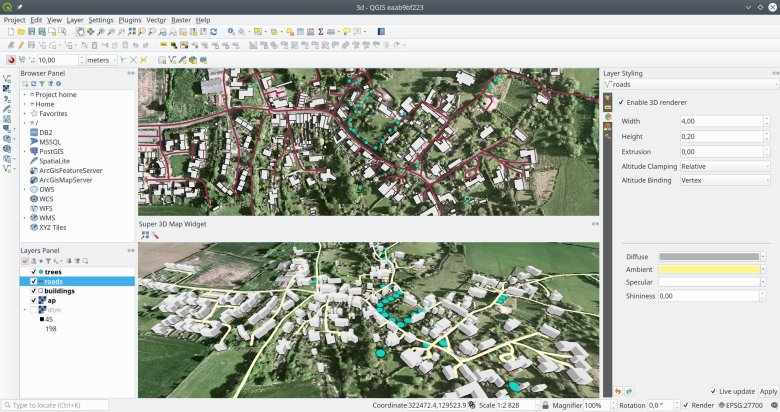
Results are included in the QGIS 3.0 release. As proposed in the grant, a new 3D map view has been added together with GUI for easy configuration of 3D rendering. The 3D view displays terrain (either from a DEM raster layer or a simple flat area) with 2D map rendered on top of the terrain. In addition to that, vector layers can be rendered as true 3D entities: points may be visualized as simple geometric shapes or as 3D models (loaded from a file), polygons and linestrings are tessellated into 3D geometries. 2D polygons can be turned into 3D objects using extrusion, possibly with data-defined height – an easy way how to display buildings, for example. Data with 3D coordinates have the Z values in geometries respected. Although the 3D view is still in its early stages, it is already usable for many use cases. Hopefully this functionality will help to attract even more users to QGIS!

More details: https://github.com/qgis/QGIS-Enhancement-Proposals/issues/105

Improvements to relations – Régis Haubourg

Various improvements for deep relations with PostgreSQL were successfully added in QGIS 3.0:

Add consistency to UI controls – Nyall Dawson

We’ve unified all the various opacity, rotation and scale controls to use the same terminology and numeric scales. We’ve also updated ALL methods for setting opacity, rotation and scale within the PyQGIS API to use consistent naming and arguments, making the API more predictable and easy to use. Lastly, we’ve also added a new reusable opacity widget (QgsOpacityWidget) to the GUI library so that future code can (and 3rd party scripts and plugins) can follow the new UI conventions for opacity handling.

Extend unit test coverage for geometry classes – Nyall Dawson

We’ve extended the unit testing coverage for all the underlying geometry primitive classes (points, lines, polygons, curves, collections, etc) so that all these classes have as close to 100% unit test coverage as possible. In the process, we identified and fixed dozens of bugs in the geometry library, and naturally added additional unit tests to avoid regressions in future releases. As a result QGIS’ core geometry engine is much more stable. Furthermore, we utilised the additional test coverage to allow us to safely refactor some of the slower geometry operations, meaning that many geometry heavy operations will perform much faster in QGIS 3.0.

Processing algorithm documentation – Matteo Ghetta & Alexander Bruy

The new Help system is landed and already available: when opening a Processing algorithm and clicking on the Help button, the guide of the algorithm will be showed in the default browser.

Many of the QGIS Processing algorithm guides have been enhanced with pictures and new or enhanced descriptions. A consistency number of Pull Requests have been already merged and many others are in review. Just a few descriptions need to be still enhanced.

Currently all the QGIS algorithms have been described and all the PR in the doc repository have been merged (kudos to Harrissou for all the reviews!).

Right now the Help button of each Processing dialog will open the related page of the algorithm, BUT:

  • if the name of the algorithm is made by only ONE word (e.g. clip, intersection…), the help button will open the browser to also the correct section (that is, the user will see directly the description of the related algorithm)
  • if the name of the algorithm has >1 words (e.g. split polygon with lines, lines to polygon, ecc.) the Help button will open the correct page (so the algorithm GROUP) but is not able to go to the correct algorithm anchor. This is because sphinx converts “split with lines” in “split-with-lines” while QGIS system will always cast the words “split-with-lines” in “splitwithlines”. Not a big deal, but IMHO a pity.
    We are really too close to the solution.

So Processing Help system right now consists of:

  • QGIS algs -> documented
  • GDAL algs -> documented
  • GRASS -> documented (own docs)
  • Orfeo -> documented (own docs)
  • SAGA -> nothing documented

Thanks to QGIS Grants to provide this chance to give a big improvement to the Processing framework even if not in a coding way!


Last but not least, we had another project that was not part of the grant programme but was also funded by QGIS.ORG in 2017:

Python API documentation – Denis Rouzaud

QGIS Python API Documentation is created using Sphinx and this work is available on Github. The repo is a fork of QGIS’ one and has been merged in the meantime. The docs are available at qgis.org/pyqgis. It uses a new theme (sphinx_rtd_theme aka ReadTheDocs theme). Some improvements were brought in (not exhaustive):

  • QGIS theming with colors and icon
  • Foldable toctree
  • Summary of methods and attributes for classes
  • Module index (not available before)
  • Correct display of overloaded methods

Full Python signature in Docstring

In former SIP versions, it was not possible to use the auto generated signature if a Docstring already existed. This means any documented method could not have a signature created. Unfortunately for this project, the vast majority of methods in QGIS API are documented!

The source code of SIP was modified and theses changes got merged upstream. See rev 1788 to 1793 in SIP changelog. It will be released in upcoming 4.19.7 version. QGIS source code was modified accordingly to prepend auto generated Python signatures to existing Docstrings. Using a CMake configuration file for each module (core.sip.in, gui.sip.in, etc.) was required to avoid syntax errors when using former version of SIP (since bumping minimum version is not realistic).

Sipify adjustments

Many things were fixed in sipify script :

  • Creation of links to classes, methods
  • Handling/fixing of Doxygen annotations \see, \note, \param
  • Handling of code snippets: c++ vs Python. Only Python are shown.

Thank you to everyone who participated and made this round of grants a great success and thank you to all our sponsor and donors who make this initiative possible!

Anita

QGIS Grants #3: Call for Grant Proposals 2018

Dear QGIS Community

Our first two rounds of Grant Proposals were a great success. If you are an early adopter using QGIS 3.0, you can already try out some of the new capabilities that have arrived in QGIS thanks to these grants.

We are very pleased to announce the third round of grants is now available to QGIS contributors. The deadline for this round is Sunday, 13 May 2018. All the details for the grants are described in the application form, and for more context we encourage you to also read these articles:

We look forward to seeing all your great ideas about how to improve QGIS!

Anita Graser

QGIS PSC

QGIS Grants: Call for applications

We are pleased to announce the first round of funding for the QGIS grant programme.

What is the grant programme?

The QGIS.ORG grant programme is our way to accelerate and streamline development of the QGIS.ORG project by rewarding committed developers and contributors for their work through a grant system. It is a way to distribute our funds amongst our team members in a fair and transparent way.

Why have a grant programme?

There are four main reasons for embarking on a grant programme.

  1. The first intent of the grant programme is to amplify the contributions of grantees by allowing them to spend more time on QGIS over and above what they would be able to do on a purely volunteer basis. At the broader level we would also like to avert the potentially negative reaction to funded development work in QGIS: “Why should I donate my time to work on QGIS when others are paid to do it?” And rather create an aspirational environment: “If I make a large contribution to QGIS I could also be eligible for a grant like other dedicated contributors have received.”
  2. To simplify the decision making process for how to spend the funds received in the QGIS project via our Sponsorship and Donations programmes. The grant programme would allow us to streamline our decision making when it comes to funding developers. We receive many proposals for funding various activities in QGIS which invariably lead to protracted debate. In addition, not having a cohesive plan for how to disburse QGIS funds results in funding being done in a very ad hoc manner – which in turn results in a skew of funding towards development related activities and away from other critical project activities such as improvement of user documentation, API documentation, sysadmin tasks and so on.
  3. To get things done that volunteers don’t naturally gravitate towards doing, such as housekeeping, maintenance and so on.
  4. To transparently spend QGIS.ORG funds to advance the QGIS project.

In this funding round, we are ring-fencing EUR 20,000 for the grant programme. We expect to run further grant calls in the future if this round proves to be a success and as funds allow.

Applicants may submit more than one proposal and the proposal may be on any topic that you think is relevant and beneficial to the greater QGIS community. Some examples of the kinds of topics you could propose are:

  • Updating and improving documentation
  • Updating and improving QGIS.org web infrastructure
  • Implementing a new feature in QGIS
  • Curating the pull request queue
  • Bug fixing
  • Improving API documentation
  • Improving the API and help making QGIS 3.0 a reality
  • Rewriting and improving a part of the code base
  • A security review of QGIS
  • Helping new QGIS devs to get started with improved developer documentation and utilities
  • etc.

The closing date for applications is Thursday, 15 September 2016

PLEASE NOTE: All applications made here will be PUBLICLY VISIBLE, including your name.

FAQ:

Here are a list of frequently asked questions relating to the grant call. Please check back on this article regularly – we will update it as any new questions are raised so that everyone may benefit from the answers.

1) Q: Are collaborative proposals allowed?

A: One person should be the proposal lead though. Additional collaborators can be mentioned in the proposal details section.

2) Q: Can I make a proposal for a smaller amount?

A: Yes

3) Q: Can I make a proposal for a larger amount?

A: No

4) Q: Can I charge VAT / additional expenses on top of the grant allocation?

A: No, the amount should be all-inclusive.

5) Q: How will the grant awards be decided?

A: Grant applications will be decided on by vote of the QGIS Board Voting Members

6) Q: Can the grant be made on behalf of my company or a group of people?

A: Yes. Just note that any application you make should be inclusive of all costs, VAT, Taxes etc.

7) Q: How many grants will be awarded from the 20,000 Euros?

A: We expect to award at minimum two grants, possibly more if there are a number of smaller grant proposals that are worthwhile.

8) Q: Can I make more than one application?

A: Yes

9) Q: Is this like Google Summer of Code – a mentorship programme?

A: No. We will not provide mentorship – we expect that you are already an established developer or contributors to the QGIS project and do not need any ‘hand holding’ other than via normal community consultation processes like QEP’s.

10) Q: I am thinking of submitting a proposal to do XYZ. Would that be considered a valid proposition?

A: We don’t have any specific pre-conceived ideas of what a valid proposal is, so I would encourage you to make a submission if you think it is worthwhile. During the decision about which proposals to access, we will consider factors like:

  • how broadly useful the proposal is to all our users,
  • how unlikely is it that the feature or improvement would be done without Grant funding,
  • how much ‘value’ does the work bring to the project,
  • how feasible is it that the applicant will actually achieve their goals etc.

11) Q: Have you thought of how to handle situations where person A submits a proposal and, later, person B submits the same proposal but cheaper?

A: In these cases, we will use criteria such as the applicant’s standing in the community, the technical details of their implementation plan, etc. Price would probably be a low-weighted factor but certainly could enter into it if there is a significant difference.

12) Q: I’ve read that QGIS 3 might land in first quarter of 2017 (if everything goes well). Do you expect proposals to be tied to QGIS 3? Should bug fixes, plugins, PyQGIS book translations, should they be planned, developed, and tested against QGIS 3’s code base?

A: Where proposals relate to the code base, yes we would expect that they are ‘3.0 ready’ – though they do not necessarily have to be completed when 3.0 is released.

13) Q: Do you have an indication of how long it will take for the grants to be awarded after the closing date?

A: It’s a bit hard for me to say how long it is going to take. The process will entail asking the QGIS voting community to rank all the proposals. Depending on how many proposals we receive we will need to allow for sufficient time of this to happen. We hope we can do it within a month of the closing date for applications but it we get a hundred proposals we will need more time probably….
Q: I still have questions, who can I ask?

A: Please contact [email protected] if you have further questions, or write to the pic mailing list.


How to apply:

To apply please use this online form


  • Page 1 of 1 ( 19 posts )
  • grants

Back to Top

Sustaining Members