Related Plugins and Tags

QGIS Planet

QGIS Annual General Meeting – 2023

Dear QGIS Community,

We recently held our 2023 QGIS Annual General Meeting. The minutes of this meeting are available for all to view.

This year, we did not have PSC elections. Anita Graser will continue as Vice-Chair, I will continue to serve on the PSC as chair, and our longstanding treasurer, Andreas Neumann, will complete the board. Furthermore, Jürgen Fischer, Alessandro Pasotti, and Régis Haubourg will continue on the PSC. Last but certainly not least, the PSC is completed by our project founder, Gary Sherman, and long-term PSC member Tim Sutton, who serve on the PSC as honorary PSC members. They both set the standard for our excellent project culture, and it is great to have his continued presence.

QGIS has been growing from strength to strength, backed by a fantastic community of kind and collaborative users, developers, contributors and funders. This year, we reached another important milestone for the project’s sustainability by welcoming our first flagship sustaining member – Felt. I look forward to seeing how it continues to grow and flourish.

Rock on QGIS!

Cheers

Marco Bernasocchi (QGIS.ORG Chair)

QGIS Annual General Meeting – 2022

Dear QGIS Community,

We recently held our 2022 QGIS Annual General Meeting. The minutes of this meeting are available for all to view.

I would like to welcome our new QGIS PSC member: Régis Haubourg. Régis has been a geomatics enthusiast for years and started deploying and funding QGIS development in 2008 as a GIS and database administrator for a water basin agency.

From 2016 to 2021, he worked for Oslandia mainly on QGIS, learned “the developer’s” side of things and could professionally collaborate with other great contributors to the project. Régis has been promoting the QGIS in the french User group, organizing 4 QGIS french user days, and being the local chapter chair for 2 years. Since 2022, he has worked for a scientific institute promoting greener construction and retrofitting methods to fight against climate change. Welcome! We’re very excited to start working with you!

I’d like to take a moment to deeply thank Paolo Cavallini for all his work in QGIS and in the QGIS PSC.

Paolo got involved in QGIS very long ago, first as a user, then more and more deeply in various activities, initiating and supporting various plugins and core functions (e.g. GDAL Tools, DB Manager), opening and managing bugs, taking care of GRASS modules, handling the trademark registration, etc. Paolo also acted as Finance and Marketing Advisor for several years before taking over the plugin approval process.

Between 2018 and 2020 Paolo served as PSC chair helping QGIS rapidly evolve into a more and more professional project. In 2020 Paolo was reelected as a member of the QGIS PSC where he has been helping in different roles.

Looking up the source code in GIT, I see that your first commit back in May 2011 was the translation of the words: Avvio, Scegli and Arrivo (Begin, Choose, Stop). I really hope that your next commit will be the translation of “Ri-Avvio” since I’m sure you still have a lot to give to QGIS as a community member!

Grazie di cuore!

I will continue to serve on the PSC as chair, and Anita Graser will take over the role of Vice-Chair. The board is completed by our longstanding treasurer Andreas Neumann.

I am also pleased to say that the project governance is in good hands with Jürgen Fischer and Alessandro Pasotti kindly making themselves available to serve on the PSC for another two years.

It is also great to know that our project founder, Gary Sherman, and long-term PSC member Tim Sutton continue to serve on the PSC as honorary PSC members. They both set the standard for our great project culture, and it is great to have his continued presence.

QGIS has been growing from strength to strength, backed by a really amazing community of kind and collaborative users, developers, contributors and funders. I look forward to seeing how it continues to grow and flourish.

Rock on QGIS!

Cheers

Marco Bernasocchi (QGIS.ORG Chair)

QGIS Annual General Meeting – 2021

Dear QGIS Community

We recently held our 2021 QGIS Annual General Meeting. The agenda included approval of the annual report and financial report 2020, as well as the new budget for 2022.

The minutes of this meeting are available for all to view.

Regards

Marco Bernasocchi (QGIS.ORG Chair)

QGIS Phasing out 32-bit support on Windows

QGIS will drop 32-bit support on Windows after the QGIS 3.16 release when we update our Qt dependencies to Qt 5.15. 

The Plan

QGIS will drop 32-bit Windows support in the next few months. QGIS 3.16 LTR will still be available for 32-bit systems. 32-bit support will be dropped during the process of updating Qt to version 5.15. Due to the complexity of the involved tasks, there is no fixed date for when this update will happen.

Reasoning

Over the last years, pretty much all new computers (including low-end machines) have been built with 64-bit processors. Our latest QGIS user survey (https://blog.qgis.org/2020/04/02/ltr-usage-survey/) confirmed that this move to 64-bit had been almost completed on the hardware side and only 7% of survey respondents indicated that they are still using 32-bit. Therefore, we have decided to phase out 32-bit support in QGIS since we have many libraries to update in the next months and we have only limited resources.

Further roadmap

The update to Qt 5.15 is an important step towards staying in sync with Qt developments. Qt 5.15 is the minimum version that will provide forward compatibility with Qt 6. By updating to 5.15, we, therefore, ensure that QGIS is future proof.  

Anita Graser receives the 2020 Sol Katz Award

It is with great pleasure that on behalf of the PSC and the whole QGIS community I’d like to extend the most heartfelt congratulations to Anita for receiving the Sol Katz Award. 

Anita has been a pillar of the QGIS community since she joined her first hackfest in Vienna in 2009. Since then she has been pushing QGIS’ boundaries and has helped thousands of people to do so through all her publications, ideas and answers on her blog, stackexchange, on the QGIS documentation and in the 7(!) books she co-authored on QGIS. Anita is also the author of the hugely popular TimeManager QGIS plugin that was the precursor of the temporal manager added in QGIS 3.14.

Since 2013 Anita has been an irreplaceable member of the PSC. Dedicated, precise, and foremost always ready to lend a helping hand, Anita is a unique example of a passionate Open Source advocate.

Thanks for all you do Anita and congratulations, nobody deserved the Sol Katz award more than you!

The Sol Katz Award for Geospatial Free and Open Source Software (GFOSS) is awarded annually by OSGeo to individuals who have demonstrated leadership in the GFOSS community. Recipients of the award will have contributed significantly through their activities to advance open source ideals in the geospatial realm. The hope is that the award will both acknowledge the work of community members, and pay tribute to one of its founders, for years to come.

Greetings from your new QGIS project Chair

Dear community,

First of all, I would like to thank Paolo for his work during the last two years as Chair and for the years before that, and years to come in his role as PSC member. I’m looking forward to keeping up the good work with him.

Secondly, I would like to thank all the community voting members for all the great inputs during the discussion phase of the AGM and for the fantastic participation in the voting process where we had more than an 80% turnout.

It is a pleasure to see that besides approving the more formal points (annual report, financial report, budget and auditors), the AGM approved all matters arising:

  • We now have two new honourable voting members: Harrissou Sant-anna and Nyall Dawson. Honourable members are specially designated voting members, whose position does not need to be affiliated with a country user group. Congratulations, and thank you, you are both such an inspiring example to our community!
  • Many QGIS users and contributors are geoscientists or geoinformatics specialists. As such, we need to act responsibly and serve as role models. Thanks to the approval of our new environmental policy, QGIS.ORG and the QGIS community committed ourselves to act responsibly regarding our actions and activities where it has any relevant influence on the environment. This will mainly affect our server infrastructure and our physical contributor meetings. The complete policy can be found in appendix 1 of our AGM minutes or on our website.

Beyond thanking Paolo as outgoing chair, I’d especially like to thank Tim, Andreas, Anita and Jürgen for the great work they are doing in the PSC and in general the incredible drive they have in helping to make QGIS thrive. I’m sure that with the help of our new Vice-Chair Alessandro Pasotti we’ll be able to take QGIS to even greater heights. Welcome, Alessandro!

Last, but definitely not least, I’d like to thank every single member of this amazing community for all your help documenting, coding, translating, testing, designing, teaching, supporting and in general spreading the QGIS love.

I never thought, when I first started using QGIS 0.6 in 2005 that 15 years later I would be given the honour of becoming the official face of such an amazing heart.

Have a great week, rock on QGIS!

Marco Bernasocchi

Incoming Chair of the QGIS.ORG Board


For Reference, here an extract of my published vision for QGIS.org:

I want to help QGIS and it’s community thrive under the value proposition of:

Making the most amazing opensource GIS that provides users with value and that meets their needs by providing great functionality and usability, being cost-effective whilst being actively supported by a vibrant and knowledgeable community.

Sharing our work under an open-source license is part of the approach by which we achieve that value proposition as it allows broad collaboration with our developers and users community.

I see FOSS as a very socially responsible way to develop software, but even more, I see the immense technological advantage that writing open-source code brings. This is why I want our focus to be on allowing both pragmatic and ideological views to respectfully coexist and enrich each other.

One of my main motivations to be part of the PSC and to make myself available as project Chair is to help QGIS keep this incredible growth rate by being even more attractive to new community members, sponsors and large/corporate users. To achieve this, the key is maintaining the right balance between sustainable processes (that guarantee the great quality QGIS has been known for) and an interesting and motivating grassroots project to ensure that QGIS remains an attractive project for volunteers to contribute to and help QGIS and its community to grow to become even more the reference [Open Source] GIS project.

QGIS Annual General Meeting – 2020

Dear QGIS Community

We recently held our 2020 QGIS Annual General Meeting. The minutes of this meeting are available for all to view.

I would like to welcome our new QGIS Board Chair: Marco Bernasocchi and our new QGIS Board Vice-Chair and QGIS PSC Member, Alessandro Pasotti. In case you are not familiar with Marco and Alessandro, you can find short introductions to them below. I will continue to serve on the PSC and am pleased also to say that the project governance is in good hands with Jürgen Fischer, Andreas Neumann and Anita Graser kindly making themselves available to serve on the PSC for another two years. It is also great to know that our project founder, Gary Sherman, as well as long-term PSC member Tim Sutton continue to serve on the PSC as honorary PSC members. They both set the standard for our great project culture and it is great to have his continued presence.

QGIS has been growing from strength to strength, backed by a really amazing community of kind and collaborative users, developers, contributors and funders. I am looking forward to seeing how it continues to grow and flourish and I am excited and confident it will do so with Marco acting as the project chair and representative. Rock on QGIS!

Marco Bernasocchi (http://berna.io @mbernasocchi)

I am an open source advocate, consultant, teacher and developer. My background is in geography with a specialization in geographic information science. I live in Switzerland in a small Romansh speaking mountain village where I love scrambling around the mountains to enjoy the feeling of freedom it gives me. I’m a very communicative person, I fluently speak Italian, German, French English and Spanish and love travelling.

I work as director of OPENGIS.ch which I founded in 2011. Since 2015 I share the company ownership with Matthias Kuhn. At OPENGIS.ch LLC we (6 superstar devs and myself) develop, train and consult our client on any aspect related to QGIS.

My first QGIS (to be correct for that time QuantumGIS) ever was “Simon (0.6)” during my BSc when the University of Zurich was teaching us proprietary products and I started looking around for Open Source alternatives. In 2008, when starting my MSc, I made the definitive switch to ubuntu and I started working more and more with QGIS Metis (0.11) and ended developing some plugins and part of Globe as my Masters thesis. Since three years the University of Zurich invites me to hold two seminars on Entrepreneurship and Open Source. In November 2011 I attended my first Hackfest in Zürich where I started porting all QGIS dependencies and developing QGIS for Android under a Google Summer of Code. A couple of years and a lot of work later QField was born. Since then I’ve always tried to attend at least to one Hackfest per year to be able to feel first hand the strong bonds within our very welcoming community. In 2013 i was lucky enough to have a release named after a suggestion I saved you all from having QGIS 2.0 – Hönggerberg and giving you instead QGIS 2.0 – Dufour. In 2018 I’ve been honored to be nominated Co-chair of the QGIS PSC, since then I’ve been taking care of GitHub, the user groups, running votes, elections, doing some small work on the website, giving more talks on opensource advocacy and foremost helping in the day to day work needed to help our amazing project keep on growing.

Beside my long story with QGIS as user and passionate advocate I have a long story as QGIS service provider where we are fully committed to its stability, feature richness and sustainable development. For that in 2019 we started our own QGIS sustainability initiative financed through our support contracts.

Alessandro Pasotti (@elpaso https://www.itopen.it, https://www.qcooperative.net)

I am an open source software developer and I live in Italy. By education I’m an agronomist with some topography and pedology background, but I turned to the dark side early in my career and I started programming any kind of device that has a chip inside as soon as their price dropped low enough. I started using Linux in 1994 and after some real work as an R&D data analyst for a big pharmaceutical company I started my own small business that was making map-based web applications for the touristic market (there was no Google Map and such at that time) and it is for this reason that I discovered GRASS, Mapserver, PostGIS and finally QGIS when I needed a GIS viewer.

Over the years I’ve made minor contributions to several open source projects and I created a bunch of QGIS Python plugins, but it is from the QGIS Lisbon Hack-Fest in 2011 that I really got involved within the community and my first big contribution was a new website for the fast growing set of QGIS Python plugins (the one that it is already in production today at https://plugins.qgis.org ).

8 years ago I re-started to write some C++ code and I’m now a QGIS core developer and a proud member of this amazing community.

Regards

Paolo Cavallini (outgoing Chair)

QGIS Annual General Meeting – 2018

Dear QGIS Community


We recently held our 2018 QGIS Annual General Meeting. The minutes of this meeting are available for all to view. As I have previously announced, I have decided to step down as chair of the PSC this year, so this post is my last official act as QGIS Chair. Thank you all for the kind words and deeds of support you gave me during my time as project chair.

I would like to welcome our new QGIS Board Chair: Paolo Cavallini, and our new QGIS Board Vice-Chair and QGIS PSC Member, Marco Bernasocchi. In case you are not familiar with Paolo and Marco, you can find short introductions to them below. I am pleased also to say that the project governance is in good hands with Richard Duivenvoorde, Jürgen Fischer, Andreas Neumann and Anita Graser kindly making themselves available to serve on the PSC for another two years. It is also great to know that our project founder, Gary Sherman, continues to serve on the PSC as honorary PSC member. Gary set the standard for our great project culture and it is great to have his continued presence.

QGIS has been growing from strength to strength, backed by a really amazing community of kind and collaborative users, developers, contributors and funders. I am looking forward to seeing how it continues to grow and flourish and I am excited and confident it will do so with Paolo acting as the project chair and representative. Rock on QGIS!


Paolo Cavallini

Paolo

I got involved in QGIS long ago, first as a user, then more and more deeply in various activities, initiating and supporting various plugins and core functions (e.g. GDAL Tools, DB Manager), opening and managing bugs, taking care of GRASS modules, handling the trademark registration, etc. I acted as Finance and Marketing Advisor for several years. Currently, I manage the plugin approval process. Motivation: It’s such a pleasure building up, in a truly cooperative and democratic way, together with truly intelligent people, a tool that enables people to freely do their job or pursue their interests, that I cannot resist helping as much as I can.

Marco Bernasocchi (http://berna.io @mbernasocchi)

20180214_112925.jpg

I am an open source advocate, consultant, teacher and developer. My background is in geography with a specialization in geographic information science. I live in Switzerland in a small Romansh speaking mountain village where I love scrambling around the mountains to enjoy the feeling of freedom it gives me. I’m a very communicative person, I fluently speak Italian, German, French English and Spanish and love travelling. I work as director of OPENGIS.ch which I founded in 2011. Since 2015 I share the company ownership with Matthias Kuhn. At OPENGIS.ch LLC we (4 superstar devs and myself) develop, train and consult our client on any aspect related to QGIS. My first QGIS (to be correct for that time QuantumGIS) ever was “Simon (0.6)” during my BSc when the University of Zurich was teaching us proprietary products and I started looking around for Open Source alternatives. In 2008, when starting my MSc, I made the definitive switch to Ubuntu and I started working more and more with QGIS Metis (0.11) and ended developing some plugins and part of Globe as my Masters thesis. Since three years the University of Zurich invites me to hold two seminars on Entrepreneurship and Open Source. In November 2011 I attended my first Hackfest in Zürich where I started porting all QGIS dependencies and developing QGIS for Android under a Google Summer of Code. A couple of years and a lot of work later QField was born. Since then I’ve always tried to attend at least to one Hackfest per year to be able to feel first hand the strong bonds within our very welcoming community. In 2013 I was lucky enough to have a release named after a suggestion I saved you all from having QGIS 2.0 – Hönggerberg and giving you instead QGIS 2.0 – Dufour Beside my long story with QGIS as user and passionate advocate I have a long story as QGIS service provider where we are fully committed to its stability, feature richness and sustainable development. Furthermore, as WorldBank consultant, I am lucky enough to be sent now and then to spread the QGIS goodness in less fortunate countries. Motivation: One of my main motivation to be part of the PSC is to help QGIS keep this incredible growth rate by being even more attractive to new community members, sponsors and large/corporate users. To achieve this, the key is maintaining the right balance between sustainable processes (that guarantee the great quality QGIS has been known for) and an interesting and motivating grassroots project where community members can bloom and enjoy contributing in their most creative ways.


Regards

timsutton

Tim Sutton (outgoing Chair)

2017 QGIS Governance Update


Screen Shot 2017-05-22 at 11.33.46 PM
QGIS Developers and Community Members working on QGIS at our recent meet up in Essen, German,

Dear Voting members (and interested QGIS community members out there)

This is an open letter that was emailed to all QGIS voting members today

Just a quick note from me to thank you for participating in our ‘virtual AGM’ – I know it is a bit of an unusual system but it suits our geographically diverse nature well and we seem to have pretty good participation in the process (though I really encourage those voting members who did not participate to do so next time!).
I have done a bunch of updates on our governance section of the web site so you can find the AGM minutes, annual report, budget etc. all on the site, and I (or whoever is chair) will post them there in future years too so everything is in one place and easy to access. Here with the relevant links:
Since we have approved a new version of the statutes, I have replaced the old PSC page on the web site with the new charter:
Thank you all for the many useful hints, tips and suggestions I regularly receive on how to make things smoother within the project (keep them coming!) – hopefully we will get into a steady routine with this governance now. We have been going through a lot of ramp up trying to get templates, processes, etc in place as we switch over to QGIS.ORG legal entity etc. We appreciate your patience while we figure things out – and a very big thank you to Andreas Neumann and Anita Graser who have pitched in with a lot of administrative work behind the scenes to help get the QGIS legal entity in place!
What’s next? I will be starting the nomination process for 4 new community voting members, soon (one to match each of the incoming country user groups for Norway, Sweden, South Africa and France). At the end of that process we will have 31 voting members.
Soon QGIS.ORG will be in the Swiss Trade Registry, which means we can be VAT registered, can take ownership of the QGIS.ORG trademark (which is currently held in proxy for us) and of course present ourselves as a well governed project, hopefully attractive to large funders who recognize the global good a project like QGIS does!
Regards
timsutton
Tim Sutton
QGIS Project Steering Committee Chair

Logo Evolution – Call to User Groups

With QGIS 3.0 moving closer, it is also time to get the new QGIS logo out there.

QGIS logo evolution

We are therefore asking all our user groups to join the project redesign efforts. Please have a look at your user group logo and bring it in line with the QGIS 3.0 design.

We have compiled a Visual Style Guide which provides all logo materials, including fonts that you can use for your own user group logo. Here is an example of how the Italian user group has updated their logo:

Italian user group redesigned

We are looking forward to seeing all your creative efforts!


Minutes of the Inaugural QGIS General Meeting (2016)

Dear QGIS community members

At the end of December 2016, we held our inaugural Annual General Meeting (AGM). It should be noted that QGIS AGM’s will be ‘virtual’ meetings conducted as a questionnaire (for voting / raising motions) and then a report such as the one below, with optional follow up email discussion if deemed necessary. The reason for this is that our community is spread far and wide and any attempt at an in-person (physical or virtual) meeting will prove very difficult given the number of different time zones the participants live in. Thus this, and future, AGM reports will be a reflection / summary of the various online activities that constitute the ‘AGM’ and the reports should be read with this understanding in mind.  It should also be kept in mind that because we are bootstrapping the QGIS Board, the 2016/ 2017 meetings follow a reduced agenda – the 2018 meeting will commence with the full AGM agenda since we will have a year of financial reporting / board activity etc. behind us. Here follow the minutes:


Minutes of the Inaugural General Assembly (AGM) 2016 – Concluded 22 December 2016

Dear QGIS.ORG voting members,

In December 2016 we held a special Inaugural AGM event in order to bootstrap the new governance structures for QGIS.ORG. The following items were tabled during our special AGM to cater for the needed transition from the old organisation to the new:

Election of incoming board and PSC member replacements

Under our statutes, existing board / PSC members are automatically put forward for re-election during our PSC elections. A call for nominations was held and closed on 15 December 2016. All voting members were elegible to put forward their nominations. The following valid nominations were received (i.e. for candidates who were not already PSC members):

  1. Régis Haubourg

Subsequent to the call for nominations, an election was held via online vote. Response rate was 20 out of 27 eligible voters. Under our statutes this is considered a quorum. Election results were as follows:

Position Name Votes Received Max Votes
Chair: QGIS Board Tim Sutton 19 20
Vice-Chair: QGIS Board Paolo Cavallini 12 20
Treasurer: QGIS Board Andreas Neumann 20 20
PSC Member Richard Duivenvoorde 17 20
PSC Member Anita Graser 16 20
PSC Member Jϋrgen Fischer 14 20
Honorary PSC Member Gary Sherman

Note that each voting member was allowed 6 votes, but was not allowed to vote for the same person more than once. For the Board Member positions, which were specifically named, the candidate with the greatest number of votes for each role assigned that role. The PSC member positions were calculated based on the total number of votes each candidate received (including those allocated to named board roles). In accordance with our statutes, Gary Sherman remains on the PSC on a permanent basis as Honorary PSC member.

Election of the board chair

Election of the board chair was carried out as part of the general voting process. The successful candidate was Tim Sutton.

Matters brought forward by voting members

There were no matters brought forward by voting members.

Annual AGM for 2017

Now that the special AGM has been held and the Board and PSC constituted, we will hold our first AGM in the first quarter of 2017 (and then each year thereafter will be held in the first quarter). The 2017 AGM will be a reduced format since we will have just elected the PSC and Board,

Agenda for 2017 AGM:

  1. Approval of the annual report (2016) by the chair
  2. Approval of the annual financial report (2016)
  3. Approval of the 2017 budget
  4. Election of two financial auditors for the upcoming year
  5. Deal with matters brought forward by voting members


Given the outcomes of the end-2016 AGM, the QGIS Governance now looks like this (click for larger version):

qgisoperationalstructure

If you have any queries about the QGIS Governance processes, please do not hesitate to ask!

Regards

timsutton

Tim Sutton (QGIS Project Chair)


QGIS 3.0 logo voting results

It is our pleasure to announce that the QGIS.org voting members have unanimously agreed to the adoption of the proposed new logo.

qgis-logo_anita0

We are currently planning the roll out of the new logo to all our applications, web platforms, and social media accounts. In addition, we will create marketing material with the new QGIS branding.  Since this is a volunteer effort, we are planning to approach this step-by-step. The goal is to have everything ready by the time of the QGIS 3.0 release.

If you are interested in helping with this effort, please leave a comment here and we will get in touch!


Happy new year 2017!

2016 was an exciting year for us. It was a year with three great releases (2.14 LTR, 2.16 & 2.18), lots of developer and community events (including our 2nd user conference in Girona, the developer meeting in Bonn before FOSS4G & a QGIS Server sprint in Lyon) and many firsts, including the first round of QGIS grants and our new QGIS.org organizational structure.

Group picture from Girona

Many of these initiatives would not be possible without support by our community, dedicated developers and our sponsors, who enable us to keep up our infrastructure and improve software and documentation. We’re particularly proud to welcome three user groups among our top sponsors, with the Swiss user group as our most prominent Gold sponsor:

sponsors
QGIS gold and silver sponsors

Thank you for helping us improve the QGIS experience for everyone!

If you are following this blog, you are already aware that we have even bigger plans for 2017, including but not limited to the big QGIS 3.0 release and a completely overhauled QGIS logo.

We’re looking forward to another great year with the QGIS community.

Keep on QGISing!


New QGIS 3.0 logo candidate

If you have been following this blog and the QGIS community discussions, you will know that 2017 is going to be a big year in the history of QGIS since we are planning the release of QGIS 3.0. One of the requests we had during our Girona Hackfest held earlier this year was to come up with a fresher logo for QGIS. Some of you may remember that we had an abortive attempt at coming up with a new logo a couple of years ago. We found that process quite difficult to manage since we tried to do it in a completely open way and there were so many differing opinions, varying tastes and so on that the whole process reached an impasse and we decided to shelve the idea for time being. With that history in mind we decided to approach the logo updating process for QGIS 3.0 differently this time around  and use a professional designer to come up with a design and then provide the QGIS Voting Members with a simple, binary YES/NO choice as to whether they accept the new logo or not.

Our current logo is a revised, polished version of the original QGIS logo:

qgis_logo_v0-1
The first (left) and second (right) generations of the QGIS logo.

While we’ve all grown to love the yellow ‘Q’ with the green arrow (no comic pun intended), the design choices, such as glow effect and drop shadows look dated. Probably the biggest problem with the current logo is that there is also no consistent logo variant that spells out ‘QGIS’ without duplicating the Q. For the logo refresh we came up with a list of requirements for the new design:

  • It should look more modern than the current logo
  • Avoid any clichés with compass, north arrow and avoid image elements
  • The logo has to work as a :
    • Large and small application icon (on computer desktop, menus, …)
    • On big posters & banners
    • On stickers to place on laptops etc
    • On t-shirts and other promotional materials
    • On letterheads etc.
  • Should work well in monochrome (or have a monochrome variant)
  • Square and rectangular variants should be possible
  • If possible, keep element(s) from the current design. It is important for the new logo to try to retain some of these elements (Q, arrow, colors, …) so people can still recognize the QGIS brand.
  • There should be a variant that includes the whole word ‘QGIS’ or ‘QGIS.ORG’. Currently when we place the logo next to the word QGIS we get a redundant QQGIS or we need to carefully match fonts to make it work
  • As an application icon, it must work on light or dark backgrounds without modification
  • As a general logo, it should have accepted variants that work on light or dark backgrounds
  • Font has to be open source
  • We should also consider how the logo and accent colours can be used in different contexts, e.g. stationery, stickers, …

We went through many iterations, reducing the number of options on each iterations as we applied the above criteria to the candidates. We would like to now present our final candidate (monochrome icon, colour icon, full logo):

While retaining the traditional yellow and green, the addition of a new third colour is a nice play on version 3.0. In addition, the old arrow is now a more natural part of the Q and there is a version designed to spell out QGIS.

Soon we will be asking the QGIS Voting Members to vote in order to affirm or reject this new logo. If it is approved we will start the process of rebranding QGIS for version 3.0. If not we will go back to the drawing board and repeat the process until we come up with a logo the QGIS Voting Members are happy with …


Winning QGIS Grant Proposals for 2016

We are extremely pleased to announce the winning proposals for our 2016 QGIS.ORG grant programme. Funding for the programme was sourced by you, our project donors and sponsorsNote: For more context surrounding our grant programme, please see:

Our intent with the QGIS.ORG Grant Programme is to support work from community that would typically not be funded by client/contractor agreements, and that contributes to the broadest possible swathe of our community by providing cross-cutting, foundational improvements to the QGIS Project.

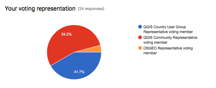
Voting to select the successful projects was carried out by our QGIS Voting Membership. Each voting member was allowed to select up to 6 of the 18 submitted proposals by means of a ranked selection form. The full list of votes are available here (on the first sheet). The second sheet contains the calculations used to determine the winner (for full transparency). The table below summarizes the voting tallies for those proposals that received one or more votes, along with brief notes on the methodology used:

screen-shot-2016-10-04-at-11-02-38-pm

A couple of extra notes about the voting process:

  • Voting was carried out based on the technical merits of the proposals and the competency of the applicants to execute on these proposals.
  • No restrictions were in place in terms of how many proposals could be submitted per person / organization, or how many proposals could be awarded to each proposing person / organization.
  • Although the budget for the grant programme was €20,000.00, the total amount for the three winning proposals is €20,500.00 – an additional €500.00 was made available by the PSC towards the grant programme to accommodate this.
  • Voting was ‘blind’ (voters could not see the existing votes that had been placed).

As mentioned in our previous blog post about this selection process, this is the first time that we have asked our newly formed group of QGIS Voting Members to vote. It is extremely gratifying to see such enthusiastic participation in the voting process. Of the 27 voting members, 24 registered their votes. There was one late submission that unfortunately had to be excluded, and 2 non-votes.

screen-shot-2016-10-03-at-2-58-20-pm
On behalf of the QGIS.ORG project, I would really like to thank everyone who submitted proposals for this call. There were many interesting proposals that I believe would be of great benefit to QGIS and I hope others perusing the proposals list will use their initiative and funding interesting proposals independently if they can.

Below you can find the detailed proposals of the successful applications – we look forward to seeing the results of their work land in the code base soon!


Details of the approved grant proposals


Implement a flexible properties framework in QGIS (Nyall Dawson) – €10,000


Details: I am applying for a QGIS grant to cover the implementation of a flexible “properties framework” for QGIS. I honestly believe that implementation of this framework will unlock cartographic power in QGIS well beyond anything that is currently possible in any of the desktop or web based mapping applications.

I propose to implement a system of managing and evaluating properties for generic objects within QGIS. Properties include all settings relating to symbology, such as a line marker’s width, color, or offset, label settings (eg font size, color, shadow opacity, etc), diagram properties (colors, size, etc) and composer item settings (position, rotation, frame size and color, etc). While currently many of the properties can be set to use “data defined overrides”, the properties framework will extend these capabilities by making them both more flexible and easier to use.

This proposal is being driven by a number of factors:

1. To avoid the current multiple duplicate code paths involving storage, retrieval and evaluation of data defined properties and to make it easier to add data defined support to more things (eg diagrams) without incurring even more duplicate code. Currently labeling, symbology and composer all have their own methods for handling data defined properties, which makes maintenance of data defined code very difficult.

2. To allow creation of other property types besides the current “data defined” (ie bound to field value or expression result) property, eg time based properties for a future in-built animation framework.

3. To avoid the complexity of requiring users to write their own expressions to map values to colors, sizes, etc and apply scaling functions to these, and instead expose these to users in an interactive, flexible way. Think Mapbox studio’s approach to zoom level styling (https://cloud.githubusercontent.com/assets/1829991/17850412/6a0f285e-68a0-11e6-8719-cdf74afd061d.jpg), but available for all property types. Eg data defined values can be set to preset ease in/ease out curves, or manually edited curves through an interactive GUI.

4. Enable the possibility of having live project wide colors. Ie a color palette could be created in the project properties, and color based properties “bound” to these colors. Altering the color would then automatically update every property which was bound to this preset color. This also brings the possibility of “color themes” for maps, eg binding properties to a predefined color types such as “highlights”, “background features”, etc, and then interactively changing all these color bound properties by applying a color theme to the project.

5. To allow a system of inherited and overridden properties. Eg QGIS default label font overridden by a project default font and finally overridden by label font setting. The proposed composer rewrite (layouts work) would use this property inheritance to bind layout item properties to a dynamic template. Changes in the template would be reflected in all linked layouts, but individual items could overwrite the inherited properties as required. Layout item properties could then be set globally (eg, font size), per project (eg font family), via a “master template” and finally individually per layout item.

6. The labelling engine has a need for predefined label styles. Label properties could be set globally, per project, via a predefined style, or overridden for a particular layer.

Technical details regarding this proposal are available in QEP 22 (https://github.com/qgis/QGIS-Enhancement-Proposals/issues/38).

I am seeking funding to:

1. Implement the core functionality for the properties framework
2. Port symbology, labeling and diagrams to the framework, and enable data definable control of all appropriate diagram settings (currently diagrams have a very limited data defined control available)
3. Implement the GUI for the property framework, including:
– a widget for controlling property behaviour
– interactive widgets for size and color properties (which have been designed to work inside 2.16’s live layer styling dock)
– interactive widgets for setting the “easing” for properties, with choices of preset ease in/out methods + an interactive curve editor for manual control

If funds are remaining following these items, I will undertake (in order of priority):

4. Bound project colors
5. Begin work on labeling styles

History: Because I believe so firmly that this framework is required within QGIS, I have been building toward this work through numerous hours of development over the previous 2 years of QGIS releases. There were a number of prerequisite changes required first, such as the implementation of expression contexts. An initial PR (https://github.com/qgis/QGIS/pull/2857) for the properties framework was filed in May 2016, which includes some of the core parts of this proposal. Changes were required based on feedback from that PR , however to date all work on this has been on a volunteer, unsponsored basis and unfortunately I am no longer able to complete such large scale changes as are required by this proposal without funding. Aside from the changes required from the initial PR, significant work remains in implementing GUI, unit tests, and porting symbology and labeling to the new framework.

Qualifications: I have an extensive history of large-scale contributions to QGIS since 2013 and a proven track record for writing polished UI with extensive unit testing. I’m passionate about QGIS, being a daily GIS user and strongly believe that this framework is required to take QGIS to the next level of cartographic abilities.

Implementation Plan: Due to the extensive refactoring and API changes which are required for implementing the properties framework, this work MUST be done in the QGIS 3.0 timeline. If it is not completed during the 3.0 API break period, the amount of work and cost required would substantially increase, and numerous methods across the symbology, labeling and diagrams API would be deprecated. Accordingly this work will be conducted during the QGIS 3.0 timeline, and for greatest testing I would aim to complete the work ASAP (likely complete by late October). Due to the changes required this work would NOT be suitable to backporting to the >= 2.18 branch and will be targeted at QGIS 3.0 only.

Proposal Link:  A QEP detailing technical implemention is available at: https://github.com/qgis/QGIS-Enhancement-Proposals/issues/38, and an initial PR available at https://github.com/qgis/QGIS/pull/2857


Introduce everything necessary for QGIS3 to OSGeo4W (Jürgen Fischer)- €6,000


Details: For QGIS3 we need packages of Qt5, PyQt5 and Python 3 (including many extensions currently available for Python 2).   The goal of this proposal is to introduce all required dependencies to OSGeo4W (32&64bit) that are necessary to build and package QGIS3. The requested amount will cover 60h of work on this.

History: I also did the packaging of Qt4, PyQt4 and QGIS.  I’ve also already started to build and package Qt 5.7 using Visual C++ 2015.

Qualifications: See previous point (or well known history)

Implementation Plan: I plan on doing it this in Q4 this year to have it available for the release and I don’t expect significant extra effort to support Windows (ie. if the issues are solved on a platform that already has Qt5 and friends available it should also work on Windows).

Implement an inbuilt Task Manager in QGIS for background long running tasks (Nyall Dawson) – €4,500

Details: QGIS requires a centralised, in built task manager to handle background threading of long running analysis tasks. Currently these long running tasks are either conducted while blocking the UI (such as when a snapping index is built for a layer) leading users to conclude that QGIS has frozen, via blocking progress dialogs which prevent interaction with QGIS while the operation proceeds, or via custom threaded implementations. By building a standard framework for handling these long running tasks, we will benefit by:


1. Avoiding UI blocking tasks, allowing users to continue working while the task is completed.
2. Simplify background task threading for plugin, processing algorithm (and core) developers by exposing a simple API for creating and scheduling long running tasks.
3. Benefit from the stabler code which comes as a result of having a single, well tested implementation of background threading rather than multiple custom implementations of this code.
4. We “catch up” to our commercial competitors (ie ArcGIS and MapInfo Professional), who currently have inbuilt background threading of long running tasks already available in their software.

This work was begun in https://github.com/qgis/QGIS/pull/3004, however significant changes are still required before the task manager can be merged into QGIS. It is vital that the task manager implementation is rock solid and with a future proof API which addresses our needs for the 3.x release cycle.

Accordingly, this grant proposal covers:

1. Building off the work started in the pull request, first addressing the feedback received from GitHub and from direct conversations with interested stakeholders and stabilising the API.
2. Completion of the unit tests to cover all parts of the framework.
3. Polish the GUI for interacting with running and completed tasks.
4. Writing documentation for the Python cookbook demonstrating how the task manager should be used from Python code.

(Please note that this proposal does not cover porting any existing code (such as processing) across to the new framework.)

History: An initial prototype of the work was begun in https://github.com/qgis/QGIS/pull/3004  

Qualifications: I have an extensive history of complex changes to QGIS code, and am currently one of the most active QGIS core developers. I have a track record of implementing stable, heavily unit tested code and supporting code I write for extended periods. I am also a daily user of QGIS as a GIS software application, so am invested in making the software as powerful, stable and easy to use as possible!

Implementation Plan: This work would be completed ASAP to allow for lengthy testing prior to the QGIS 3.0 release, and to allow the maximum time possible for developers to adapt their code and plugins to the new task manager interface.

Proposal Link: An initial prototype of the work was begun in https://github.com/qgis/QGIS/pull/3004, and a video demonstration is available at https://www.youtube.com/watch?v=7pXBZtWYFJc   


Call for nominations for voting members of the QGIS.org board.

Dear QGIS Community members
As many of you will be aware, in this last year we have been embarking on the process to transition from a loose-knit community organisation to a more formal organisation. This new organisation ‘QGIS.org’ will be a legal entity and will afford us a greater amount of flexibility in how we manage funds, legal agreements and so forth. You can read the statutes for the QGIS.org organisation for more info.
Under the statutes of the new organisation, there will be one user group voting member put forward for each registered user group (user group registration page is here). For each user group voting member we will have a community voting member elected. In addition there will be one voting member from the OSGEO leadership. It is probably best explained by way of a simple (contrived) example:

1) The Martian user group puts forward Joe Alien to be their QGIS User Group Voting Member.
2) QGIS committers put forward nominations for a matching Community Voting Member from within the community. Community member with the highest number of nominations is elected. Only people with git commit rights to an official QGIS repository or write access to the QGIS translation platform on transifex can put forward nominations. The nominated person can be any person from within the QGIS community who is willing to serve as a voting QGIS community member.
3)  The Moon user group puts forward Janet Luna to be their QGIS User Group Voting Member.
4) QGIS committers again nominate a matching Community Voting Member
5) OSGEO puts forward one person to act as the OSGEO voting member.

Voting members will elect the QGIS Board, Board Chairman and approve budgets and the annual report. Once elected, the board will make day to day decisions on behalf of the project as needed. The OSGEO voting member will also serve to ensure that there are always an odd number of voting members to avoid deadlocks. Voting members will have their continued membership confirmed on a 3 yearly basis.
Since we are bootstrapping the QGIS.org organisation, we have not yet elected any voting members. Currently there are 10 QGIS User Groups registered (this number may be different when you read this due to new registrations), thus we would like to invite all people who have Git commit access to any official QGIS repo, or transifex write access to make their nominations for their community voting members. The 10 consenting nominees with the highest number of nominations will be appointed as community voting members.
We will close the nomination period on Wed 11 May if at least 10 unique persons have been nominated, otherwise as soon as 10 unique persons have been nominated.
We will maintain a list of the QGIS Voting Members on the web site for public viewing.
After all of the voting members have been elected they will be asked to elect the members of the board. Board members need not be voting members, any QGIS community member can be elected to the board. For formation of the new board, existing PSC members will automatically be nominated and the community voting members can also put up additional nominations. We would then put the election of the board members to a vote (maintaining the same number of members as are currently in the PSC for now). Once the board has officially been elected, the voting members can then select a chair for the board. Note that all voting will be done electronically via an online form.
By this process we will have a democratically elected board entrusted with stewardship of the new QGIS.org Organisation.
Each year we will hold an annual general meeting and voting members can elect a new chair, or re-elect the existing chair. Similarly on a rotational basis, board members will be up for re-election each year. If things are a little unclear above, I have made a simple diagram which hopefully clarifies things (see below).
QGIS.orgStructure.png
Note that Gary Sherman (QGIS project founder) is board member emeritus and this will not be up for re-election as he has life long tenure on the board.
So if you are eligible to nominate voting members (i.e. you are a committer on any official QGIS repo or a Transifex author), please head over to the form provided to  make your nomination!
timsutton
Tim Sutton
Current QGIS Project Steering Committee Chair

  • Page 1 of 1 ( 16 posts )
  • qgis board

Back to Top

Sustaining Members