We are extremely pleased to announce the winning proposals for our 2020 QGIS.ORG grant programme. Funding for the programme was sourced by you, our project donors and sponsors! Note: For more context surrounding our grant programme, please see: QGIS Grants #5: Call for Grant Proposals 2020.
The QGIS.ORG Grant Programme aims to support work from our community that would typically not be funded by client/contractor agreements. This means that we did not accept proposals for the development of new features. Instead proposals focus on infrastructure improvements and polishing of existing features.
Two proposals focusing on documentation improvements were funded directly from the documentation budget. The remaining 10 proposals continued on to the voting.
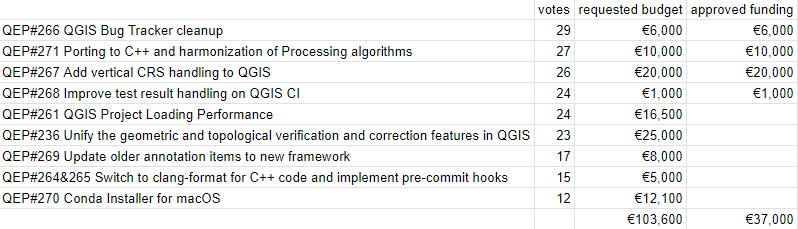
Voting to select the successful projects was carried out by our QGIS Voting Members. Each voting member was allowed to select up to 6 proposals. The full list of votes are available here (on the first sheet). The following sheets contain the calculations used to determine the winner (for full transparency). The table below summarizes the voting tallies for the proposals:

Thanks to the generous support by our sponsors and donors, we are happy that all proposals will receive funding, even if QEP#124 had to be reduced in scope (core part only, no GUI: €2,600 from QGIS grants & €1,400 sponsored by OPENGIS).
A couple of extra notes about the voting process:
- Voting was carried out based on the technical merits of the proposals and the competency of the applicants to execute on these proposals.
- No restrictions were in place in terms of how many proposals could be submitted per person / organization, or how many proposals could be awarded to each proposing person / organization.
- Voting was ‘blind’ (voters could not see the existing votes that had been placed).
We received 34 votes from 21 community representatives and 13 user group representatives.
On behalf of the QGIS.ORG project, I would like to thank everyone who submitted proposals for this call!


 the QGIS loading times