Related Plugins and Tags

QGIS Planet

FOSS4G SotM Oceania 2023 Auckland round up

Recently, we had the pleasure of helping organise the FOSS4G SotM Oceania 2023 conference in Auckland. It was a fantastic week and felt like a worthy return to pre-covid events full of great presentations, catching up with old friends, making new ones, and of course – delicious food! The venue, Auckland University of Technology, put on a really professional event with catering, venue spaces and their Audio Visual operations. Auckland gave us great weather, and great venues to enjoy each others company in.

We were blown away with the variety of presentations and the talent our Oceania region holds. We got to meet some of our clients in person including Koordinates, A.B. Heritage and Soar, which we loved, plus we spent valuable time connecting with our community.

At North Road we are passionate about supporting open-source and our local Oceania region, so we took an active part in making this year’s conference happen. Aside from being a conference sponsor, our very own powerhouse Emma Hain worked tirelessly as Program Chair to organise the conference program and ensure that the talks ran smoothly and were of very high value.  Nyall ran a workshop for Advanced Cartography, presented on his journey in the FOSS4G workspace and contributed as panel member on making  a living in FOSS4G. Emma also presented a lightning talk on GitHub QGIS Issues and was a community day facilitator on an exciting project to develop digital stories with a map component. We really love community and being involved in “building it” is integral. But it is also super fun as well!

One of the great things about this conference is the legacy it leaves, not only in the relationships formed, but in the recordings of all the presentations that end up on the FOSS4G Oceania YouTube channel. This is not only knowledge captured for the community, but also a showcase for the talent that exists in FOSS4G. Not every  presentations was technical or about case studies, they also covered personal observations, hobbies and general mapping topics.

You can view the presentations from our staff below:

Also, check out the presentations from some of the great companies we have worked with:

Soar: Soar: lessons from our start-up experience, From Satellites to Slobs,   Maps, Media and Manipulation

Koordinates: Kart – the geospatial version control system – now with Rasters!Making it up: map making bots, generative mapping and TTRPG tools

Community Day

On the last day of the conference we attended the Community Day. This involves a Mapathon run by HOTOSM, and rooms for brainstorming and workshopping of ideas. These were really valuable! First we attended the FOSS4G Hui run by Byron Cochrane from OpenWork (one of the conference sponsors). It was a great discussion on how to make FOSS4G more relevant in Oceania. If you are keen to help out with this, contact the OSGeo Oceania Board – as they need helpers with Communications and members to espouse FOSS4G at outside conferences.

Emma also ran the session on developing digital stories with a map component in a FOSS4G environment. This was well attended with a lot of ideas. We developed our MVP and we are now looking at our next steps. The question here is do we develop a new tool within existing software, find a standalone software where we could add in a map component, or approach a current OS Story Map software and provide our MVP and find funding. If you’re keen to take part in these discussions, you can join in on the Maptime Oceania slack channel under #foss4g-productdev.

A Big Thank-you!

The Organisation committee worked so hard on putting this conference on, and we would like to express our heartfelt thanks for this. This is the keystone event for our community and so much grows from this. Without the Organisation Committee’s sweat, tears, frustration and joy this would not have happened. We thank their families who supported them whilst they gave up their valuable time and their employers who supported them to give their time and effort to making this special event happen.

Bring on FOSS4G/SOTM Oceania 2024!

GRASS GIS 8.3.0 released

What’s new in a nutshell

The GRASS GIS 8.3.0 release provides more than 360 changes compared to the 8.2 branch. This new minor release brings in many fixes and improvements in GRASS GIS modules and the graphical user interface (GUI) which now has the single window layout by default. Some of the most relevant changes include: support for parallelization in three raster modules, new options added to several temporal modules, and substantial clean-up of g.extension, the module that allows the installation of add-ons. The GUI also received a lot of attention with many fixes and items reorganised. We have also adopted the Clang format and indented most of the C code accordingly. A lot of effort was put into cleaning up the C/C++ code to fix almost all compiler warnings.

Translations have been moved from Transifex to Weblate, which automatically creates pull requests with the translated chunks. We’d like to thank the translators of all languages for their long term support!

GRASS GIS 8.3

Also, docker images have been updated and moved from the mundialis to the OSGeo organization at https://hub.docker.com/r/osgeo/grass-gis/.

We have carried out quite some work in the GitHub Actions: we added support for “pre-commit” in order to reduce unnecessary runs of the automated checks, there were notable improvements in the code checking section and we have activated renovatebot to automatically maintain GitHub Actions.

Last but not least, we have significantly improved the automated release creation to reduce maintainer workload and we have gained nine new contributors! Welcome all!!

Full list of changes and contributors

For all 360+ changes, see our detailed announcement with the full list of features and bugs fixed at GitHub / Releases / 8.3.0.

Thank you all contributors!!

Download and test!

Binaries/Installers download

Further binary packages for other platforms and distributions will follow shortly, please check at software downloads.

Source code download

First time users may explore the first steps tutorial after installation.

About GRASS GIS

The Geographic Resources Analysis Support System (https://grass.osgeo.org/), commonly referred to as GRASS GIS, is an Open Source Geographic Information System providing powerful raster, vector and geospatial processing capabilities. It can be used either as a stand-alone application, as backend for other software packages such as QGIS and R, or in the cloud. It is distributed freely under the terms of the GNU General Public License (GPL). GRASS GIS is a founding member of the Open Source Geospatial Foundation (OSGeo).

The GRASS Dev Team

The post GRASS GIS 8.3.0 released appeared first on Markus Neteler Consulting.

GRASS GIS 8.0.0 released! Finally…

Overview of changes

After more than 3 year of development the first stable release GRASS GIS 8.0.0 is available. Efforts have concentrated on making the user experience even better, providing many new useful additional functionalities to modules and further improving the graphical user interface.

Breaking news: new graphical user interface with entirely rewritten startup sequence!

This re-establishes user experience compatibility with QGIS and other connected software packages.

The GRASS GIS 8.0.0 release provides more than 1,400 fixes and improvements with respect to the release 7.8.6.

With the introduction of the semantic label raster metadata class, the temporal database was modified to version 3. Hence, to be able to read and process GRASS 7.x space-time datasets, users will be prompted to run t.upgrade. If users want to read newly created space-time datasets back in GRASS 7.x, they can run t.downgrade.

Launching the software

The user experience of the graphical user interface has been completely rewritten: no more clumsy selection screens – just enter the menu system directly! And on command line, GRASS GIS now starts versionless, i.e. as grass. Enjoy!

Download and detailed list of changes

Thanks to all contributors!

GRASS GIS 8.0.0RC2 contributors

The post GRASS GIS 8.0.0 released! Finally… appeared first on Markus Neteler Consulting.

GRASS GIS 8.0.0RC2 released

Overview of changes

After more than 3 year of development the first stable release GRASS GIS 8.0.0 is available. Efforts have concentrated on making the user experience even better, providing many new useful additional functionalities to modules and further improving the graphical user interface.

Breaking news: new graphical user interface with entirely rewritten startup sequence!

This re-establishes user experience compatibility with QGIS and other connected software packages.

The GRASS GIS 8.0.0 release provides more than 1,300 fixes and improvements with respect to the release 7.8.6.

With the introduction of the semantic label raster metadata class, the temporal database was modified to version 3. Hence, to be able to read and process GRASS 7.x space-time datasets, users will be prompted to run t.upgrade. If users want to read newly created space-time datasets back in GRASS 7.x, they can run t.downgrade.

Launching the software

The user experience of the graphical user interface has been completely rewritten: no more clumsy selection screens – just enter the menu system directly!

And on command line, GRASS GIS now starts versionless, i.e. as grass.

Download and detailed list of changes

See https://github.com/OSGeo/grass/releases/tag/8.0.0RC2

Thanks to all contributors!

GRASS GIS 8.0.0RC2 contributors

The post GRASS GIS 8.0.0RC2 released appeared first on Markus Neteler Consulting.

(Fr) Financement mutualisé du logiciel libre: le cas QGIS

Sorry, this entry is only available in French.

GRASS GIS 7.8.2 released

GRASS GIS 7.8.2 released with updated PROJ 6 and GDAL 3 support

What’s new in a nutshell

As a follow-up to the recent GRASS GIS 7.8.1 we have pusblished the new stable release GRASS GIS 7.8.2.
Besides other improvements, the release contains important PROJ 4/5/6 related datum handling fixes, wxGUI fixes and a fix for the vector import from PostGIS databases.

An overview of the new features in the 7.8 release series is available at new features in GRASS GIS 7.8.

Binaries/Installer download:

Source code download:

See also our detailed announcement:

First time users may explore the first steps tutorial after installation.

About GRASS GIS

The Geographic Resources Analysis Support System (https://grass.osgeo.org/), commonly referred to as GRASS GIS, is an Open Source Geographic Information System providing powerful raster, vector and geospatial processing capabilities in a single integrated software suite. GRASS GIS includes tools for spatial modeling, visualization of raster and vector data, management and analysis of geospatial data, and the processing of satellite and aerial imagery. It also provides the capability to produce sophisticated presentation graphics and hardcopy maps. GRASS GIS has been translated into about twenty languages and supports a huge array of data formats. It can be used either as a stand-alone application or as backend for other software packages such as QGIS and R geostatistics. It is distributed freely under the terms of the GNU General Public License (GPL). GRASS GIS is a founding member of the Open Source Geospatial Foundation (OSGeo).

The GRASS Development Team, December 2019

The post GRASS GIS 7.8.2 released appeared first on GFOSS Blog | GRASS GIS and OSGeo News.

Remarks on SVN-trac to GitHub migration

GRASS GIS is an open source geoinformation system which is developed by a globally distributed team of developers. Besides the source code developers also message translators, people who write documentation, those who report bugs and wishes and more are involved.

1. Early days… from pre-Internet to CVS and SVN

While GRASS GIS is under development since 1982 (no typo!) it has been put into a centralized source code management system in December 1999. Why so late? Because the World Wide Web (WWW) became available in the 1990s along with tools like browsers and such, followed by the development of distributed source code management tools. We moved on 29th Dec 1999 (think Y2K bug) the entire code into our instance of CVS (Concurrent Versioning System). With OSGeo being founded in 2006, we migrated the CVS repository to SVN (Subversion for the source code management) and trac (bug and wish tracker) on 8 Dec 2007. See here for historic details on our various bug trackers.

2. Time to move on: git

Now, after more than 10 years using SVN/trac time had come to move on and join the large group of projects managing their source code in git (see also our related Wiki page on migration). Git comes with numerous advantages, yet we needed to decide which hosting platform to use. Options where github.com, gitlab.com, gitlab or gitea on OSGeo infrastructure, or other platforms. Through a survey we found out that the preference among contributors is GitHub. While not being open source itself it offers several advantages: it is widely known (good to get new developers interested and involved), numerous OSGeo projects are hosted there under the GitHub “OSGeo organization“.

If all fails (say, one day GitHub no longer being a reasonable choice) the import of our project from GitHub to GitLab is always possible. Indeed, we meanwhile mirror our code on OSGeo’s gitea server.

Relevant script code and migration ticket:

Relevant steps:

  • migrated SVN trunk -> git master
  • migrated and tagged release branches (milestones)
  • deleted “develbranch6” (we compared it to “releasebranch_6_4” and didn’t discover relevant differences)
  • Fix commit messages (yes, we really wanted to be brave, updating decades of commit messages!):
    • references to old RT tracker tickets (used Dec 2000 – Dec 2006)
    • references to old GForge tracker tickets (used Jan 2007 – Dec 2008)
    • references to other trac tickets (#x -> https://trac.osgeo.org/…)

3. Source code migration: the new git repositories

  • github repository “grass” (repo)

    • Source code from 1999 to present day (SVN-trunk -> git-master)
    • all 7.x release branches
  • github repository “grass-legacy” (repo)

    • separate repository for older GRASS GIS releases (3.2, 4.x, 5.x, 6.x), hence source code now available in git since 1987!
  • github repository “grass-addons” (repo)

    • repository for addons
  • github repository “grass-promo” (repo)
    • repository for promotional material
  • github repository “grass-website” (repo)
    • repository for upcoming new Website

4. Remarks on the “grass-legacy” repository

What special about it:

  • the source code goes back to 1987!
  • file timestamps (which I tried to preserve for decades :-) have been used to reconstruct the source code history (e.g., releasebranch_3_2)
  • junk files removed (plenty of leftover old binary files, files consisting of a special char only etc)
  • having this grass-legacy repo available in parallel to the main grass repo which contains the  recent source code we have a continuous source code coverage from 1987 to today in git.
  • size is about 250MB

What’s missing

  • the 4.3 source code doesn’t have distinct timestamps. Someone must have once packaged without mtime preservation… a pity. Perhaps a volunteer may fix that by carrying over the timestamps from GRASS GIS 4.2 in case the md5sum of a file is identical (or so).

5. Trac issue migration

A series of links had to be updated. Martin Landa invested days and days on that (thanks!!). He used the related GDAL efforts as a basis (Even Rouault: thanks!). As the date for the trac migration we selected 2007-12-09 (r25479) as it was the first SVN commit (after the years in CVS). The migration of trac bugs to github (i.e. transfer of trac ticket content) required several steps:

Link updates in the ticket texts:

  • links to other tickets (now to be pointed to full trac URL). Note that there were many styles of referring in the commit log message which had to be parsed accordingly
  • links to trac wiki (now to be pointed to full trac URL)
  • links source code in SVN (now to be pointed to full trac URL)
  • images and attachments (now to be pointed to full trac URL)

Transferring:

  • “operating system” trac label into the github issue text itself (following the new issue reporting template)
  • converting milestones/tickets/comments/labels
  • converting trac usernames to Github usernames
  • setting assignees if possible, set new “grass-svn2git” an assignee otherwise
  • slowing down transfer to match the 60 requests per second API limit rate at github

6. Fun with user name mapping

Given GRASS GIS’ history of 35+ years we had to invest major effort in identifying and mapping user names throughout the decades (see also bug tracker history). The following circumstances could be identified:

  • user present in CVS but not in SVN
  • user present in SVN but not in CVS
  • user present in both with identical name
  • user present in both with different name (well, in our initial CVS days in 1999 we often naivly picked our surnames like “martin”, “helena”, “markus”, “michael” … cute yet no scaling very much over the years!) as some were changed in the CVS to SVN migration in 2007, leading to
    • colliding user names
  • some users already having a github account (with mostly different name again)

We came up with several lookup tables, aiming at catching all variants. Just a “few” hours to dig in old source code files and in emails for finding all the missing email addresses…

7. Labels for issues

We cleaned up the trac component of the bug reports, coming up with the following categories which have to be visually grouped by color since the label list is just sorted alphabetically in github/gitlab:

  • Issue category:
    • bug
    • enhancement
  • Issue solution (other than fixing and closing it normally):
    • duplicate
    • invalid
    • wontfix
    • worksforme
  • Priority:
    • blocker
    • critical
    • feedback needed
  • Components:
    • docs
    • GUI
    • libs
    • modules
    • packaging
    • python
    • translations
    • unittests
    • Windows specific

Note that the complete issue migration is still to be done (as of Nov. 2019). Hopefully addressed at the GRASS GIS Community Sprint Prague 2019.

8. Setting up the github repository

In order to avoid users being flooded by emails due to the parsing of user contributions which normally triggers an email from github) we reached out to GitHub support in order to temporarily disable these notifications until all source code and selected issues were migrated.

The issue conversion rate was 4 min per trac bug to be converted and uploaded to github. Fairly slow but likely due to the API rate limit imposed and the fact that the migration script above generates a lot of API requests rather than combined ones..
Note to future projects to be migrated: use the new gihub import API (unfortunately we got to know about its existence too late in our migration process).

Here out timings which occurred during the GRASS GIS project migration from SVN to github:

  • grass repo: XX hours (all GRASS GIS 7.x code)
  • grass-legacy repo: XX hours (all GRASS GIS 3.x-6.x code)
  • NNN issues: XX hours – forthcoming.

9. New issue reporting template

In order to guide the user when reporting new issues, we will develop a small template – forthcoming.

10. Email notifications: issues to grass-dev and commits to grass-commit

We changed the settings from SVN post-hook to Github commit notifications and they flow in smoothly into the grass-commit mailing list. Join it to follow the development.

Overall, after now several months of using our new workflow we can state that things work fine.

The post Remarks on SVN-trac to GitHub migration appeared first on GFOSS Blog | GRASS GIS and OSGeo News.

Happy birthday OSGeo!

On February 4, 2006 OSGeo held its first meeting in Chicago, with 25 participants representing 18 groups and over 20 different Open Source GIS projects, and 39 others participating via Internet Relay Chat. During the meeting, participants made important decisions in the formation and organization of the foundation, including the name, structure and purpose. The consensus reached in Chicago opened the way for the establishment of a productive and representative foundation.

Today we are happy to announce that the we have meanwhile over 32,800 unique subscribers in the huge list of over 290 OSGeo mailing lists!

And: check out the web site of the OSGeo foundation.

1. More to come this year!

… see here for the growing list of events

The post Happy birthday OSGeo! appeared first on GFOSS Blog | GRASS GIS and OSGeo News.

Thoughts on “FOSS4G/SOTM Oceania 2018”, and the PyQGIS API improvements which it caused

Last week the first official “FOSS4G/SOTM Oceania” conference was held at Melbourne University. This was a fantastic event, and there’s simply no way I can extend sufficient thanks to all the organisers and volunteers who put this event together. They did a brilliant job, and their efforts are even more impressive considering it was the inaugural event!

Upfront — this is not a recap of the conference (I’m sure someone else is working on a much more detailed write up of the event!), just some musings I’ve had following my experiences assisting Nathan Woodrow deliver an introductory Python for QGIS workshop he put together for the conference. In short, we both found that delivering this workshop to a group of PyQGIS newcomers was a great way for us to identify “pain points” in the PyQGIS API and areas where we need to improve. The good news is that as a direct result of the experiences during this workshop the API has been improved and streamlined! Let’s explore how:

Part of Nathan’s workshop (notes are available here) focused on a hands-on example of creating a custom QGIS “Processing” script. I’ve found that preparing workshops is guaranteed to expose a bunch of rare and tricky software bugs, and this was no exception! Unfortunately the workshop was scheduled just before the QGIS 3.4.2 patch release which fixed these bugs, but at least they’re fixed now and we can move on…

The bulk of Nathan’s example algorithm is contained within the following block (where “distance” is the length of line segments we want to chop our features up into):

for input_feature in enumerate(features):
    geom = feature.geometry().constGet()
    if isinstance(geom, QgsLineString):
        continue
    first_part = geom.geometryN(0)
    start = 0
    end = distance
    length = first_part.length()

    while start < length:
        new_geom = first_part.curveSubstring(start,end)

        output_feature = input_feature
        output_feature.setGeometry(QgsGeometry(new_geom))
        sink.addFeature(output_feature)

        start += distance
        end += distance

There’s a lot here, but really the guts of this algorithm breaks down to one line:

new_geom = first_part.curveSubstring(start,end)

Basically, a new geometry is created for each trimmed section in the output layer by calling the “curveSubstring” method on the input geometry and passing it a start and end distance along the input line. This returns the portion of that input LineString (or CircularString, or CompoundCurve) between those distances. The PyQGIS API nicely hides the details here – you can safely call this one method and be confident that regardless of the input geometry type the result will be correct.

Unfortunately, while calling the “curveSubstring” method is elegant, all the code surrounding this call is not so elegant. As a (mostly) full-time QGIS developer myself, I tend to look over oddities in the API. It’s easy to justify ugly API as just “how it’s always been”, and over time it’s natural to develop a type of blind spot to these issues.

Let’s start with the first ugly part of this code:

geom = input_feature.geometry().constGet()
if isinstance(geom, QgsLineString):
    continue
first_part = geom.geometryN(0)
# chop first_part into sections of desired length
...

This is rather… confusing… logic to follow. Here the script is fetching the geometry of the input feature, checking if it’s a LineString, and if it IS, then it skips that feature and continues to the next. Wait… what? It’s skipping features with LineString geometries?

Well, yes. The algorithm was written specifically for one workshop, which was using a MultiLineString layer as the demo layer. The script takes a huge shortcut here and says “if the input feature isn’t a MultiLineString, ignore it — we only know how to deal with multi-part geometries”. Immediately following this logic there’s a call to geometryN( 0 ), which returns just the first part of the MultiLineString geometry.

There’s two issues here — one is that the script just plain won’t work for LineString inputs, and the second is that it ignores everything BUT the first part in the geometry. While it would be possible to fix the script and add a check for the input geometry type, put in logic to loop over all the parts of a multi-part input, etc, that’s instantly going to add a LOT of complexity or duplicate code here.

Fortunately, this was the perfect excuse to improve the PyQGIS API itself so that this kind of operation is simpler in future! Nathan and I had a debrief/brainstorm after the workshop, and as a result a new “parts iterator” has been implemented and merged to QGIS master. It’ll be available from version 3.6 on. Using the new iterator, we can simplify the script:

geom = input_feature.geometry()
for part in geom.parts():
    # chop part into sections of desired length
    ...

Win! This is simultaneously more readable, more Pythonic, and automatically works for both LineString and MultiLineString inputs (and in the case of MultiLineStrings, we now correctly handle all parts).

Here’s another pain-point. Looking at the block:

new_geom = part.curveSubstring(start,end)
output_feature = input_feature
output_feature.setGeometry(QgsGeometry(new_geom))

At first glance this looks reasonable – we use curveSubstring to get the portion of the curve, then make a copy of the input_feature as output_feature (this ensures that the features output by the algorithm maintain all the attributes from the input features), and finally set the geometry of the output_feature to be the newly calculated curve portion. The ugliness here comes in this line:

output_feature.setGeometry(QgsGeometry(new_geom))

What’s that extra QgsGeometry(…) call doing here? Without getting too sidetracked into the QGIS geometry API internals, QgsFeature.setGeometry requires a QgsGeometry argument, not the QgsAbstractGeometry subclass which is returned by curveSubstring.

This is a prime example of a “paper-cut” style issue in the PyQGIS API. Experienced developers know and understand the reasons behind this, but for newcomers to PyQGIS, it’s an obscure complexity. Fortunately the solution here was simple — and after the workshop Nathan and I added a new overload to QgsFeature.setGeometry which accepts a QgsAbstractGeometry argument. So in QGIS 3.6 this line can be simplified to:

output_feature.setGeometry(new_geom)

Or, if you wanted to make things more concise, you could put the curveSubstring call directly in here:

output_feature = input_feature
output_feature.setGeometry(part.curveSubstring(start,end))

Let’s have a look at the simplified script for QGIS 3.6:

for input_feature in enumerate(features):
    geom = feature.geometry()
    for part in geom.parts():
        start = 0
        end = distance
        length = part.length()

        while start < length:
            output_feature = input_feature
            output_feature.setGeometry(part.curveSubstring(start,end))
            sink.addFeature(output_feature)

            start += distance
            end += distance

This is MUCH nicer, and will be much easier to explain in the next workshop! The good news is that Nathan has more niceness on the way which will further improve the process of writing QGIS Processing script algorithms. You can see some early prototypes of this work here:

So there we go. The process of writing and delivering a workshop helps to look past “API blind spots” and identify the ugly points and traps for those new to the API. As a direct result of this FOSS4G/SOTM Oceania 2018 Workshop, the QGIS 3.6 PyQGIS API will be easier to use, more readable, and less buggy! That’s a win all round!

GRASS GIS 7.4.2 released

We are pleased to announce the GRASS GIS 7.4.2 release

What’s new in a nutshell

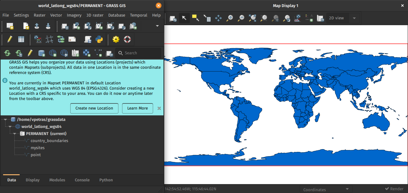
After a bit more than four months of development the new update release GRASS GIS 7.4.2 is available. It provides more than 50 stability fixes and improvements compared to the previous stable version 7.4.1. An overview of the new features in the 7.4 release series is available at New Features in GRASS GIS 7.4.

Efforts have concentrated on making the user experience even better, providing many small, but useful additional functionalities to modules and further improving the graphical user interface. Segmentation now support extremely large raster maps. Dockerfile and Windows support received updates. Also the manual was improved. For a detailed overview, see the list of new features. As a stable release series, 7.4.x enjoys long-term support.

Binaries/Installer download:

Source code download:

More details:

See also our detailed announcement:

About GRASS GIS

The Geographic Resources Analysis Support System (https://grass.osgeo.org/), commonly referred to as GRASS GIS, is an Open Source Geographic Information System providing powerful raster, vector and geospatial processing capabilities in a single integrated software suite. GRASS GIS includes tools for spatial modeling, visualization of raster and vector data, management and analysis of geospatial data, and the processing of satellite and aerial imagery. It also provides the capability to produce sophisticated presentation graphics and hardcopy maps. GRASS GIS has been translated into about twenty languages and supports a huge array of data formats. It can be used either as a stand-alone application or as backend for other software packages such as QGIS and R geostatistics. It is distributed freely under the terms of the GNU General Public License (GPL). GRASS GIS is a founding member of the Open Source Geospatial Foundation (OSGeo).

The GRASS Development Team, October 2018

The post GRASS GIS 7.4.2 released appeared first on GFOSS Blog | GRASS GIS and OSGeo News.

PDAL 1.6.0 packaged for Fedora including vertical datums and grids

Cologne city shown as colorized 3D point cloud (data source: openNRW Germany)In order to simplify the installation of the latest PDAL release (Point Data Abstraction Library, http://www.pdal.io/, version 1.6.0) on Fedora, I have created an updated set of RPM packages now including vertical datums and grids (.gtx files from here).

The installation is as simple as this (the repository is located at Fedora’s COPR):

# enable extra repos to satisfy dependencies
sudo dnf copr enable neteler/pdal-hexer
sudo dnf copr enable neteler/points2grid

# install dependencies
sudo dnf install hexer
sudo dnf install points2grid

# enable and install PDAL
sudo dnf copr enable neteler/pdal
sudo dnf install PDAL PDAL-devel PDAL-vdatums

# run PDAL:
pdal-config --version
pdal --help

Enjoy!

The post PDAL 1.6.0 packaged for Fedora including vertical datums and grids appeared first on GFOSS Blog | GRASS GIS Courses.

New major release: GRASS GIS 7.2.0 available

We are pleased to announce the stable release of GRASS GIS 7.2.0

What’s new in a nutshell

After almost two years of development the new stable major release GRASS GIS 7.2.0 is available. It provides more than 1950 stability fixes and manual improvements compared to the former stable release version 7.0.5. The new version includes a series of new modules to analyse raster and vector data along with new temporal algebra functionality.More than 50 new addons are also available. A summary of the new features is available at New Features in GRASS GIS 7.2.

About GRASS GIS 7: Its graphical user interface supports the user to make complex GIS operations as simple as possible. The updated Python interface to the C library permits users to create new GRASS GIS-Python modules in a simple way while yet obtaining powerful and fast modules. Furthermore, the libraries were again significantly improved for speed and efficiency, along with support for huge files. A lot of effort has been invested to standardize parameter and flag names. Finally, GRASS GIS 7 comes with a series of new modules to analyse raster and vector data, along with a full temporal framework. For a detailed overview, see the list of new features. As a stable release series, 7.2.x enjoys long-term support.

Binaries/Installer download:

Source code download:

More details:

See also our detailed announcement:

First time users may explore the first steps tutorial after installation.

About GRASS GIS

The Geographic Resources Analysis Support System (https://grass.osgeo.org/), commonly referred to as GRASS GIS, is an Open Source Geographic Information System providing powerful raster, vector and geospatial processing capabilities in a single integrated software suite. GRASS GIS includes tools for spatial modeling, visualization of raster and vector data, management and analysis of geospatial data, and the processing of satellite and aerial imagery. It also provides the capability to produce sophisticated presentation graphics and hardcopy maps. GRASS GIS has been translated into about twenty languages and supports a huge array of data formats. It can be used either as a stand-alone application or as backend for other software packages such as QGIS and R geostatistics. It is distributed freely under the terms of the GNU General Public License (GPL). GRASS GIS is a founding member of the Open Source Geospatial Foundation (OSGeo).

The GRASS Development Team, December 2016

The post New major release: GRASS GIS 7.2.0 available appeared first on GFOSS Blog | GRASS GIS Courses.

Reporting back from Bonn & Oslo

Over the last two weeks, I had the pleasure to attend both the international FOSS4G conference in Bonn, Germany, as well as the regional FOSS4G-NOR in Oslo, Norway. Both events were superbly organized and provided tons of possibilities to share experiences and find new inspiration.

Talks at both conferences have been recorded and can be watched online: Bonn / Oslo

I enjoyed having the opportunity to give two very different talks. In Bonn, I presented work on pedestrian routing and navigation, which was developed within the PERRON project:

It was particularly nice that we had plenty of time for Q&A after this presentation since only two talks were scheduled for this session rather than the usual three. I’d also like to thank everyone for the great feedback – both in person and on Twitter!

In Oslo, I had the honor to give the opening keynote on OpenSource in general and the QGIS project in particular:

2 – Anita Graser – QGIS – A Community-powered GIS Project from krokskogstrollet on Vimeo.

Both conferences were packed with great sessions and talks. If I had to pick favorites from last week’s presentations, I would have to opt for Iván Sánchez presenting his latest projects, including what3fucks and geohaiku:

6 – Iván Sánchez Ortega, Mazemap – Addressing NSFW Geodesic Grids from krokskogstrollet on Vimeo.

Followed closely by the impressive project presentations of the student organizers of FOSS4G-NOR:

10 – Program Committee – What are the results when students use Open Source? from krokskogstrollet on Vimeo.

All three projects: OPPTUR, GISTYLE, and the flexible traffic web viewer were great demos of what can be achieved with open source tools. Mathilde’s GISTYLE project is also available on Github.

An inspiring GISummer comes to an end, but with so many videos to watch and workshop materials to explore, I’m convinced that the autumn will be no less exciting.


Happy 9th Birthday, OSGeo!

Press release by Jeff McKenna, OSGeo Foundation President

9 years ago today was the first ever meeting of the OSGeo foundation, in Chicago U.S.A. (initial press release). Thanks to those passionately involved back then, and the thousands contributing since, now our community has expanded and has reached many countries all over world. Congratulations to everyone for continuing to share the passion for Open Source geospatial.

Here is a glimpse at some of the exciting events happening around the world this year:

The post Happy 9th Birthday, OSGeo! appeared first on GFOSS Blog | GRASS GIS Courses.

QGIS 2.6 ‘Brighton’ released

In the new release of QGIS 2.6.0 a series of new features have been added concerning

  • General: new features and bugfixes,
  • DXF export (improvements),
  • Map Composer (enhancements),
  • Processing (including a new modeler implementation),
  • QGIS Server (improvements),
  • Symbology (including user interface improvements),
  • User Interface with improvements.

A visual changelog is available for more details with lots of screenshots.

Congratulations to all QGIS developers! Looking forward to see the Fedora RPM available…

You can download QGIS 2.6 at http://qgis.org/en/site/forusers/download.html

The post QGIS 2.6 ‘Brighton’ released appeared first on GFOSS Blog | GRASS GIS Courses.

Slides FOSS4G 2014

Slides from our presentations at FOSS4G 2014 in Portland/Oregon:

@PirminKalberer

Sourcepole at FOSS4G 2014 in Portland

In one week, the 2014 FOSS4G Conference will start in Portland/Oregon. Sourcepole supports this major event as a bronze sponsor.

Our conference contributions:

Workshop presented by Horst Düster (@moazagotl)

  • Tuesday afternoon: QGIS Plugin Development with PyQt4 and PyQGIS

Presentations by Pirmin Kalberer (@PirminKalberer)

  • Thursday, Session 2, Track 7, 13:00 - 13:25: State of QGIS Server
  • Thursday, Session 2, Track 7, 13:30 - 13:55: From Nottingham to PDX: QGIS 2014 roundup
  • Thursday, Session 3, Track 6, 16:25 - 13:25: Easy ETL with OGR

Meet Pirmin and Horst at Sourcepole’s exhibition booth and have a look at our latest products.

We’re looking forward to meet you in Portland next week!

Follow @Sourcepole for selected QGIS news and other Open Source Geospatial related infos.

FOSS4G 2014 is taking off

If you want to become an active part of this year’s FOSS4G, it’s now time to start thinking about your contributions!

FOSS4G 2014 will be taking place in Portland, Oregon, USA from Sept 8th-12th. Like last year in Nottingham, there will be a regular track for presentations as well as an academic track and a series of workshops.

logo_horiz_500x231

If you are looking for inspiration, you might want the check out last year’s programme or read about the interesting story behind this years conference logo.


News in GRASS GIS 7

GRASS GIS, commonly referred to as GRASS (Geographic Resources Analysis Support System), is the free Geographic Information System (GIS) software with the longest record of development as FOSS4G community project. The increasing demand for a robust and modern analytical free GIS led to the start of GRASS GIS 7 development in April 2008. Since GRASS 6 more than 10,000 changes have been implemented with a series of new modules for vector network analysis, image processing, voxel analysis, time series management and improved graphical user interface. The core system offers a new Python API and large file support for massive data analysis. Many modules have been undergone major optimization also in terms of speed. The presentation will highlight the advantages for users to migrate to the upcoming GRASS GIS 7 release.

The post News in GRASS GIS 7 appeared first on GFOSS Blog | GRASS GIS Courses.

50th ICA-OSGeo Lab established at Fondazione Edmund Mach (FEM)

We are pleased to announce that the 50th ICA-OSGeo Lab has been established at the GIS and Remote Sensing Unit (Piattaforma GIS & Remote Sensing, PGIS), Research and Innovation Centre (CRI), Fondazione Edmund Mach (FEM), Italy. CRI is a multifaceted research organization established in 2008 under the umbrella of FEM, a private research foundation funded by the government of Autonomous Province of Trento. CRI focuses on studies and innovations in the fields of agriculture, nutrition, and environment, with the aim to generate new sharing knowledge and to contribute to economic growth, social development and the overall improvement of quality of life.

The mission of the PGIS unit is to develop and provide multi-scale approaches for the description of 2-, 3- and 4-dimensional biological systems and processes. Core activities of the unit include acquisition, processing and validation of geo-physical, ecological and spatial datasets collected within various research projects and monitoring activities, along with advanced scientific analysis and data management. These studies involve multi-decadal change analysis of various ecological and physical parameters from continental to landscape level using satellite imagery and other climatic layers. The lab focuses on the geostatistical analysis of such information layers, the creation and processing of indicators, and the production of ecological, landscape genetics, eco-epidemiological and physiological models. The team pursues actively the development of innovative methods and their implementation in a GIS framework including the time series analysis of proximal and remote sensing data.

The GIS and Remote Sensing Unit (PGIS) members strongly support the peer reviewed approach of Free and Open Source software development which is perfectly in line with academic research. PGIS contributes extensively to the open source software development in geospatial (main contributors to GRASS GIS), often collaborating with various other developers and researchers around the globe. In the new ICA-OSGeo lab at FEM international PhD students, university students and trainees are present.

PGIS is focused on knowledge dissemination of open source tools through a series of courses designed for specific user requirement (schools, universities, research institutes), blogs, workshops and conferences. Their recent publication in Trends in Ecology and Evolution underlines the need on using Free and Open Source Software (FOSS) for completely open science. Dr. Markus Neteler, who is leading the group since its formation, has two decades of experience in developing and promoting open source GIS software. Being founding member of the Open Source Geospatial Foundation (OSGeo.org, USA), he served on its board of directors from 2006-2011. Luca Delucchi, focal point and responsible person for the new ICA-OSGeo Lab is member of the board of directors of the Associazione Italiana per l’Informazione Geografica Libera (GFOSS.it, the Italian Local Chapter of OSGeo). He contributes to several Free and Open Source software and open data projects as developer and trainer.

Details about the GIS and Remote Sensing Unit at http://gis.cri.fmach.it/

Open Source Geospatial Foundation (OSGeo) is a not-for-profit organisation founded in 2006 whose mission is to support and promote the collaborative development of open source geospatial technologies and data.

International Cartographic Association (ICA) is the world authoritative body for cartography and GIScience. See also the new ICA-OSGeo Labs website.

  • Page 1 of 2 ( 31 posts )
  • >>
  • foss4g

Back to Top

Sustaining Members