QField Rapid Mapper is a project for the QField mobile app, which allows emergency responders, civil protection, military, and citizens to assess and report damages from natural catastrophes by quickly sharing geolocated images, videos and audio. QField Rapid Mapper offers real-time data collection, mapping and sharing to help enhance disaster response and coordination. QField and QFieldCloud are open-source, and OPENGIS.ch is donating the needed QFieldCloud infrastructure and expertise to help map the floods in Ticino in 2024
OPENGIS.ch Supports Flood Mapping Efforts in Ticino
After discussing with the Protezione Civile Locarno e Valle Maggia and the Centro di Competenza per la geoinformazione (CCGEO), we are proud to announce that OPENGIS.ch is donating the necessary QFieldCloud infrastructure and dedicated projects for a rapid crowdsourcing POC to aid in mapping the 2024 floods in Ticino. This crowdsourcing initiative aims to provide essential support to professionals and volunteers working on flood and landslide assessment and recovery.
Photographing damaged houses and infrastructure is the most critical aspect of this mapping initiative. These images provide crucial information for assessing the extent of the damage, planning rescue and reconstruction operations, and ensuring that resources are allocated effectively. It’s also important to document any submerged or damaged vehicles, as they offer additional insights into the disaster’s impact. During these activities, it’s essential to be careful and respect the privacy and property of others, avoiding capturing license plate numbers or entering destroyed buildings without permission. Using QField Rapid Mapper can contribute to a faster and more coordinated emergency response while ensuring respect for those affected.
The QFieldCloud infrastructure enables efficient, real-time data collection and sharing, ensuring that accurate and up-to-date information is available to all stakeholders involved in the flood response. This effort underscores our commitment to leveraging technology for social good and environmental resilience.
By participating, you will have access to powerful tools for field data collection and can contribute valuable information to the ongoing efforts in Ticino. All the data collected will be released under the Creative Commons CC0 1.0 public domain license.
Join the Effort
Using QField and QFieldCloud, you can help create detailed maps crucial for understanding the impact of the floods and planning effective recovery strategies. Your contributions will make a significant difference in managing and mitigating the effects of this natural disaster.
Visit our QField Rapid Mapper project page for more information on how QField and QFieldCloud can assist in flood mapping and other field data collection projects.
Together, we can make a difference. Join us in mapping the floods in Ticino and support the community’s recovery efforts.
This blog post will introduce QField’s brand new plugin framework and walk through the creation of a plugin to support bird watchers in need of a quick way to digitize photos of spotted birds onto a point vector layer.
As announced recently, QField now empowers users through a brand new plugin framework allowing for simple customization on the way the application behaves or looks all the way through to creating completely new functionalities.
The plugin framework relies on Qt’s QML engine and JavaScript, allowing for cross-platform support out of the box. This means that plugins will run perfectly fine on all platforms currently supported by QField: Android, iOS, Windows, Linux, and macOS.
App-wide plugin vs. project plugin
First, let’s look at the two types of plugins supported by QField: app-wide plugins and project plugins. As their names imply, the main difference is their scope. An enabled app-wide plugin will remain active as long as QField is running, while project plugins are activated on project load and deactivated when the project tied to the plugin is closed.
Project plugins are shipped alongside a given project file (.qgs/.qgz). Project plugins must share the same name of the project file with a .qml extension. For example, if your project file is birdwatcher.qgz, QField will look for the presence of a birdwatcher.qml to activate the project plugin. For app-wide plugins, installation is done via the plugins manager popup; more on this below.
Distribution of project plugins can be greatly facilitated through QFieldCloud. The presence of project plugins within a cloud project environment will be automatically detected and packaged alongside the project file and its datasets when deployed to QField devices.
Starting with a project plugin
We will start with looking into a simple project plugin that offers a new digitizing mechanism focused on snapping photos as a trigger for point feature addition. This plugin will demonstrate how new functionalities and behaviors can be added to QField to serve specific needs. In this case, the new digitizing mechanism could come in handy for bird watchers and other users in need of a quick way to snap photos!
The project archive consists of a point vector layer (observations.gpkg), a project file (birdwatcher.qgz) as well as a project plugin (birdwatcher.qml) which we will look into below. Please note that the point vector layer’s attribute form is already configured to display captured photos. We will not spend time on attribute form setup in this post; see this relevant documentation page if you are interested in knowing how that was achieved.
We can now test the project plugin by opening the project (birdwatcher.qgz) in QField. Users familiar with QField will notice a new ‘camera’ tool button present on the top-right corner of the map canvas. This button was added by the project plugin. You can press on it, to open the QField camera, take a photo (of yourself, a random object on your table, or with a bit of luck a bird), and witness how that leads to a point feature creation.
Digging into the project plugin file
Let’s open the project plugin file (birdwatcher.qml) in your favorite text editor. The first few lines define the QML imports needed by the plugin:
Beyond the two QtQuick imports, we will make use of QField-specific types and items as well as QGIS ones (registered and declared in this source file), a Theme to retrieve icons and colors as well as QField items such as tool buttons (see this source directory), as well as the QField QML items embedded into the application itself to make use of the camera.
The next line declares an generic Item component which will be used by QField to initiate the plugin. This must be present in all plugins. As this plugin does, you can use the Component.onCompleted signal to trigger code execution. In this case, we are using iface to add a tool button on top of the map canvas:
Just above these lines, the plugin declare a number of properties pointing to items found in the main QField ApplicationWindow:
property var mainWindow: iface.mainWindow()
property var positionSource: iface.findItemByObjectName('positionSource')
property var dashBoard: iface.findItemByObjectName('dashBoard')
property var overlayFeatureFormDrawer: iface.findItemByObjectName('overlayFeatureFormDrawer')
Users can reach through to any items within QField’s ApplicationWindow provided they have an objectName property defined. The string value is used in the iface.findItemByObjectName() function to retrieve the item.
The rest of the file consists of a loader to activate the QField camera, a tool button to snap a photo, and a function to create a new feature within which the current position is used as geometry and the snapped photo is attached to the feature form.
The function itself provides a good example of what can be achieved by using the parts of QGIS exposed through QML, as well as utility functions and user interface provided by QField:
function snap(path) {
  let today = new Date()
  let relativePath = 'DCIM/' + today.getFullYear()
                              + (today.getMonth() +1 ).toString().padStart(2,0)
                              + today.getDate().toString().padStart(2,0)
                              + today.getHours().toString().padStart(2,0)
                              + today.getMinutes().toString().padStart(2,0)
                              + today.getSeconds().toString().padStart(2,0)
                              + '.' + FileUtils.fileSuffix(path)
  platformUtilities.renameFile(path, qgisProject.homePath + '/' + relativePath)

  let pos = positionSource.projectedPosition
  let wkt = 'POINT(' + pos.x + ' ' + pos.y + ')'

  let geometry = GeometryUtils.createGeometryFromWkt(wkt)
  let feature = FeatureUtils.createFeature(dashBoard.activeLayer, geometry)

  let fieldNames = feature.fields.names
  if (fieldNames.indexOf('photo') > -1) {
    feature.setAttribute(fieldNames.indexOf('photo'), relativePath)
  } else if (fieldNames.indexOf('picture') > -1) {
    feature.setAttribute(fieldNames.indexOf('picture'), relativePath)
  }

  overlayFeatureFormDrawer.featureModel.feature = feature
  overlayFeatureFormDrawer.state = 'Add'
  overlayFeatureFormDrawer.open()
}
The QGIS API Documentation site is a good resource for learning what parts of the many QGIS classes are exposed to QML. For example, the QgsFeature documentation page contains a Properties section and a Q_INVOKABLE prefix next to functions indicating their availability within a QML/JavaScript environment.
Deployment of a project plugin via QFieldCloud
As mentioned above, QFieldCloud greatly eases the deployment of project plugins to devices in the field. We will now go through the steps required to create a cloud project environment based on the birdwatcher sample project, and witness it handling the project plugin automatically.
This will require you to registered for a freely available QFieldCloud community account if you haven’t done so yet (it takes a minute to do so, what are you waiting for ). We will also need the QFieldSync plugin in QGIS, which can be enabled through the QGIS plugin manager.
Let’s open QGIS, and log into QFieldCloud by clicking on the QFieldSync toolbar’s blue cloud icon. Once logged in, click on the ‘Create New Project’ tool button found at the bottom of the dialog.
In the subsequent panel dialog, choose the ‘Create a new empty QFieldCloud project’ and then hit the ‘Next’ button. Give it a name and a description, and for the local directory, pick the folder within which you had extracted the birdwatcher project, then hit the ‘Create’ button.
QFieldSync will then ask you to upload your newly created cloud project environment to the server. Notice how the project plugin file (birdwatcher.qml) is part of the files to be delivered to the cloud. Confirm by clicking on the ‘Upload to server’ button.
When QFieldSync is finished uploading, you are ready to take your mobile device, open QField, log into your QFieldCloud account and download the cloud project. Once the cloud project is loaded, you will be asked for permission to load the project plugin, which you can grant on a permanent or one-time basis.
Bravo! You have successfully deployed a project plugin through QFieldCloud.
Creating an app-wide plugin directory
Let’s move on to creating a functional app-wide plugin directory. Download this sample app-wide plugin and extract it into a new directory placed in the ‘plugins’ directory, itself found within the QField app directory. The location of the app directory is provided in the ‘About QField’ overlay, take note of it prior to extracting the plugin if you have not done so yet.
As seen in the screenshot above, which demonstrates the directory hierarchy, a given plugin directory must contain at least two files: a main.qml file, which QField will use to activate the plugin, and a metadata.txt file containing basic information on the plugin, such as the plugin name, author details, and version.
Here’s a sample metadata.txt from the birdwatcher project plugin upgraded into an app-wide plugin:
Opening main.qml in your favourite text editor will reveal that it has the exact same content as the above-shared project plugin. The only change is the renaming of birdwatcher.qml to main.qml to take into account this plugin’s app-wide scope.
While currently not as smooth as deploying a project plugin through QFieldCloud, app-wide plugins can be installed onto devices using a URL pointing to a zipped archive file containing the content of a given plugin directory. The zipped archive file can then be hosted on your own website, on a GitHub or GitLab repository, a Dropbox link, etc.
In QField, open the plugins manager popup found in the settings panel, and use the ‘Install plugin from URL’ button to paste a URL pointing to a zipped plugin file.
You should keep the zipped archive file name consistent for a better user experience, as it is used to determine the installation directory. This is an important consideration to take into account when offering plugin updates. If your zipped plugin file name changes, the plugin will not be updated but rather added to a new directory alongside the previously installed plugin.
QField does allow for a version tag to be added to a zipped archive file name, provided it is appended at the end of the file name, preceded by a dash, and includes only numbers and dots. For example, myplugin-0.0.1.zip and myplugin-0.2.1.zip will install the plugin in the myplugin directory.
Empowering users as well as developers
Here at OPENGIS.ch, we believe this new plugin framework empowers not only users but also developers, including our very own ninjas! With plugin support, we now have the possibility to develop answers to specific field scenarios that would not necessarily be fit for QField-wide functionalities. We would love to hear your opinion and ideas.
If you would like to supercharge your fieldwork and need some help, do not hesitate to contact us – your projects are our passion
P.S. If you are developing a cool QField plugin, also let us know!
Oslandia is the main partner of OPENGIS.ch around QField. We are proud today to forward the announcement of the new QField release 3.3 “Darién”. This release introduces a brand new plugin framework that empowers users to customize and add completely new functionalities to their favourite field application.
The plugin framework comes with other new features and improvements for this release, detailed below.
Main highlights
One of the biggest feature additions of this version is a brand new drawing tool that allows users to sketch out important details over captured photos or annotate drawing templates. This was a highly requested feature, which is brought to all supported platforms (Android, iOS, Windows, macOS, and, of course, Linux) with the financial support of the Swiss QGIS user group.
Also landing in this version is support for copying and pasting vector features into and from the clipboard. This comes in handy in multiple ways, from providing a quick and easy way to transfer attributes from one feature to another through matching field names to pasting the details of a captured feature in the field into a third-party messenger, word editing, or email application. Copying and pasting features can be done through the feature form’s menu as well as long pressed over the map canvas. Moreover, a new feature-to-feature attributes transfer shortcut has also been added to the feature form’s menu. Appreciation to Switzerland, Canton of Lucerne, Environment and Energy for providing the funds for this feature.
The feature form continues to gain more functionalities; in this version, the feature form’s value map editor widget has gained a new toggle button interface that can help fasten data entry. The interface replaces the traditional combo box with a series of toggle buttons, lowering the number of taps required to pick a value. The German Archaeological Institut – KulturGutRetter sponsored this feature.
Other improvements in the feature form include support for value relation item grouping and respect for the vector layer attributes’ « reuse last entered value » setting.
Finally, additional features include support for image decoration overlay, a new interface to hop through cameras (front, back, and external devices) for the ‘non-native’ camera, the possibility to disable the 3-finger map rotation gesture, and much more.
User experience improvements
Long-time users of QField will notice the new version restyling of the information panels such as GNSS positioning, navigation, elevation profile, and sensor data. The information is now presented as an overlay sitting on top of the map canvas, which increases the map canvas’ visibility while also achieving better focus and clarity on the provided details. With this new version, all details, including altitude and distance to destination, respect user-configured project distance unit type.
The dashboard’s legend has also received some attention. You can now toggle the visibility of any layer via a quick tap on a new eye icon sitting in the legend tree itself. Similarly, legend groups can be expanded and collapsed directly for the tree. This also permits you to show or hide layers while digitizing a feature, something which was not possible until now. The development of these improvements was supported by Gispo and sponsored by the National Land Survey of Finland.
Plugin framework
QField 3.3 introduces a brand new plugin framework using Qt’s powerful QML and JavaScript engine. With a few lines of code, plugins can be written to tweak QField’s behaviour and add new capabilities. Two types of plugins are possible: app-wide plugins as well as project-scoped plugins. To ensure maximum ease of deployment, plugin distribution has been made possible through QFieldCloud! Amsa provided the financial contribution that brought this project to life.
Our partner OPENGIS.ch will soon offer a webinar to discover how QField plugins can help your field (and business) workflows by allowing you to be even more efficient in the field.
QField 3.3 has been released, and with it, we are proud to introduce a brand new plugin framework that empowers users to customize and add completely new functionalities to their favourite field application. That’s on top of a bunch of new features and improvements added during this development cycle. What preceded this moment was just the beginning!
Main highlights
One of the biggest feature additions of this version is a brand new drawing tool that allows users to sketch out important details over captured photos or annotate drawing templates. This was a highly requested feature, which we are delighted to bring to all supported platforms (Android, iOS, Windows, macOS, and, of course, Linux) with the financial support of the Swiss QGIS user group.
Also landing in this version is support for copying and pasting vector features into and from the clipboard. This comes in handy in multiple ways, from providing a quick and easy way to transfer attributes from one feature to another through matching field names to pasting the details of a captured feature in the field into a third-party messenger, word editing, or email application. Copying and pasting features can be done through the feature form’s menu as well as long pressed over the map canvas. If copy pasting ain’t your style, a new feature-to-feature attributes transfer shortcut has also been added to the feature form’s menu. Appreciation to Switzerland, Canton of Lucerne, Environment and Energy for providing the funds for this feature.
The feature form continues to gain more functionalities; in this version, the feature form’s value map editor widget has gained a new toggle button interface that can help fasten data entry. The interface replaces the traditional combo box with a series of toggle buttons, lowering the number of taps required to pick a value. If you enjoy this as much as we do, send a virtual thanks to German Archaeological Institut – KulturGutRetter, which sponsored this feature.
Other improvements in the feature form include support for value relation item grouping and respect for the vector layer attributes’ “reuse last entered value” setting.
Finally, additional features that are sure to please include support for image decoration overlay, a new interface to hop through cameras (front, back, and external devices) for the ‘non-native’ camera, the possibility to disable the 3-finger map rotation gesture, and much more.
User experience improvements
Long-time users of QField will notice the new version restyling of the information panels such as GNSS positioning, navigation, elevation profile, and sensor data. The information is now presented as an overlay sitting on top of the map canvas, which increases the map canvas’ visibility while also achieving better focus and clarity on the provided details. While revisiting these information panels, we’ve made sure all details, including altitude and distance to destination, respect user-configured project distance unit type.
The dashboard’s legend has also received some attention. You can now toggle the visibility of any layer via a quick tap on a new eye icon sitting in the legend tree itself. Similarly, legend groups can be expanded and collapsed directly for the tree. This also permits you to show or hide layers while digitizing a feature, something which was not possible until now. The development of these improvements was supported by Gispo and sponsored by the National Land Survey of Finland.
Plugin framework
Last but far away from least, QField 3.3 introduces a brand new plugin framework using Qt’s powerful QML and JavaScript engine. With a few lines of code, plugins can be written to tweak QField’s behaviour and add breathtaking capabilities. Two types of plugins are possible: app-wide plugins as well as project-scoped plugins. To ensure maximum ease of deployment, we have enabled project plugin distribution through QFieldCloud! We extend our heartfelt thanks to Amsa for the financial contribution that brought this incredible project to life.
Stay tuned for an upcoming webinar and a dedicated post that will dive into how QField plugins can revolutionize your field (and business) workflows by allowing you to be even more efficient in the field.
We are thrilled to announce that the Best of Swiss Apps Enterprise winner 2022, QField, has been officially recognized as a Digital Public Good by the UN-endorsed Digital Public Goods Alliance. This prestigious recognition highlights QField’s significant contributions to six key Sustainable Development Goals (SDGs): SDG 6 (Clean Water and Sanitation), SDG 9 (Industry, Innovation, and Infrastructure), SDG 11 (Sustainable Cities and Communities), SDG 13 (Climate Action), SDG 15 (Life on Land), and SDG 16 (Peace, Justice, and Strong Institutions). The “Swiss Made Software” QField is the leading fieldwork application with almost 1 Million downloads worldwide.
Leading the Way in Fieldwork Technology
QField stands out as the leading fieldwork app, designed to bring the power of geospatial data collection and management to the fingertips of users worldwide. Developed with a user-centric approach, QField allows seamless integration with QGIS, providing a robust and intuitive platform for data collection, visualization, and analysis directly in the field. This recognition as a Digital Public Good underscores QField’s vital role in advancing digital solutions for sustainable development.
QField 3.2 Statistics
Accessible for Everyone
One of QField’s key strengths is its ease of use, making it accessible not only to professionals but also to students, researchers, and community members. Its intuitive interface ensures that users with varying levels of technical expertise can efficiently collect and manage geospatial data. This inclusivity promotes wider adoption and engagement, enhancing the app’s impact across different sectors and communities.
Land surveying project Tonga
Exemplary Open Source Project
At the heart of QField’s success is its commitment to technological excellence and open-source principles. As an exemplary open-source project, QField fosters a collaborative environment where developers and users alike contribute to continuous improvement and innovation. QField frequently contributes back to its upstream project, QGIS, ensuring mutual growth and enhancement of both platforms. This community-driven approach not only enhances the app’s functionality but also ensures that it remains accessible and adaptable to diverse needs across the globe.
Supporting Sustainable Development Goals
QField’s capabilities extend beyond just one aspect of the United Nations Sustainable Development Goals (SDGs); they intersect with multiple goals, enhancing efforts towards a sustainable future:
SDG 6: Clean Water and Sanitation: QField facilitates efficient water quality monitoring and management, ensuring communities have access to clean and safe water.
SDG 9: Industry, Innovation, and Infrastructure: By providing cutting-edge tools for infrastructure planning and development, QField drives innovation in various industries.
SDG 11: Sustainable Cities and Communities: QField supports urban planning and sustainable development, contributing to the creation of resilient and inclusive cities.
SDG 13: Climate Action: The app enables precise data collection for climate research and environmental monitoring, aiding in climate action initiatives.
SDG 15: Life on Land: QField aids in biodiversity assessments and conservation efforts, promoting the sustainable use of terrestrial ecosystems.
SDG 16: Peace, Justice, and Strong Institutions: Through its reliable and transparent data management capabilities, QField supports the development of strong institutions and governance systems.
Post-disaster assessment Tonga
A Future of Innovation and Sustainability
As we celebrate this recognition, we remain committed to pushing the boundaries of what is possible in fieldwork technology. QField will continue to evolve, driven by the needs of its global user base and the imperative to support sustainable development. We invite all stakeholders to join us on this journey towards a more sustainable and equitable future.
Marco Bernasocchi is happy to receive interview requests or queries about the project. Email:[email protected] Phone: +41 79 467 24 70 (14:00 – 18:00 CET)
QField is an open-source fieldwork app that integrates seamlessly with #QGIS, providing a powerful platform for data collection, visualization, and analysis. Designed for professionals across various sectors, QField empowers users to efficiently manage and analyze geospatial data in the field, contributing to sustainable development and innovation worldwide. Link: https://qfield.org
About the OPENGIS.ch service QFieldCloud
#QFieldCloud is a spatial cloud service integrated in #QField that allows remote provisioning and synchronisation of geodata and projects. Although “QFieldCloud” is still in an advanced beta stage, it is already being used by many groups to significantly improve their workflows. Link: https://qfield.cloud
About OPENGIS.ch:
OPENGIS.ch GmbH is a Swiss software development company based in Laax. OPENGIS.ch employs 19 people and works mainly in the field of spatial software development, geodata infrastructure deployments and professional support. Personalised open-source GIS solutions are often planned and developed as desktop or mobile applications. OPENGIS.ch finances itself through tailor-made customer solutions, professional support and adaptations. Link: https://opengis.ch
OPENGIS.ch
About Digital Public Goods Alliance (DPGA)
The Digital Public Goods Alliance is a multi-stakeholder initiative endorsed by the United Nations Secretary-General, working to accelerate the attainment of the Sustainable Development Goals in low- and middle-income countries by facilitating the discovery, development, use of, and investment in digital public goods.
For more information on the Digital Public Goods Alliance please reach out to [email protected].
Focused on stability and usability improvements, most users will find something to celebrate in QField 3.2
Main highlights
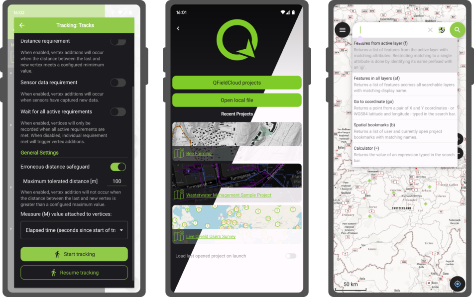
This new release introduces project-defined tracking sessions, which are automatically activated when the project is loaded. Defined while setting up and tweaking a project on QGIS, these sessions permit the automated tracking of device positions without taking any action in QField beyond opening the project itself. This liberates field users from remembering to launch a session on app launch and lowers the knowledge required to collect such data. For more details, please read the relevant QField documentation section.
As good as the above-described functionality sounds, it really shines through in cloud projects when paired with two other new featurs.
First, cloud projects can now automatically push accumulated changes at regular intervals. The functionality can be manually toggled for any cloud project by going to the synchronization panel in QField and activating the relevant toggle (see middle screenshot above). It can also be turned on project load by enabling automatic push when setting up the project in QGIS via the project properties dialog. When activated through this project setting, the functionality will always be activated, and the need for field users to take any action will be removed.
Pushing changes regularly is great, but it could easily have gotten in the way of blocking popups. This is why QField 3.2 can now push changes and synchronize cloud projects in the background. We still kept a ‘successfully pushed changes’ toast message to let you know the magic has happened
With all of the above, cloud projects on QField can now deliver near real-time tracking of devices in the field, all configured on one desktop machine and deployed through QFieldCloud. Thanks to Groupements forestiers Québec for sponsoring these enhancements.
Other noteworthy feature additions in this release include:
A brand new undo/redo mechanism allows users to rollback feature addition, editing, and/or deletion at will. The redesigned QField main menu is accessible by long pressing on the top-left dashboard button.
Support for projects’ titles and copyright map decorations as overlays on top of the map canvas in QField allows projects to better convey attributions and additional context through informative titles.
Additional improvements
The QFieldCloud user experience continues to be improved. In this release, we have reworked the visual feedback provided when downloading and synchronizing projects through the addition of a progress bar as well as additional details, such as the overall size of the files being fetched. In addition, a visual indicator has been added to the dashboard and the cloud projects list to alert users to the presence of a newer project file on the cloud for projects locally available on the device.
With that said, if you haven’t signed onto QFieldCloud yet, try it! Psst, the community account is free
The creation of relationship children during feature digitizing is now smoother as we lifted the requirement to save a parent feature before creating children. Users can now proceed in the order that feels most natural to them.
Finally, Android users will be happy to hear that a significant rework of native camera, gallery, and file picker activities has led to increased stability and much better integration with Android itself. Activities such as the gallery are now properly overlayed on top of the QField map canvas instead of showing a black screen.
The launch of QField 3.0 was a big deal, but now we’re back to focusing on smaller, more frequent updates. Don’t let the shorter change log for 3.1 trick you – there are lots of cool new features in this update!
Main highlights
One of the main improvements in this release is the brand-new functionality to enable snapping to common angles while digitizing. When enabled, the coordinate cursor will snap to configured angles alongside a visual guideline. This comes in handy when adding new geometries while surveying features with regular angles (e.g. buildings, parking lots, etc.). As QField gets more digitizing functionalities, we’ve taken the time to implement a nifty UI that collapses digitizing toggle buttons into a drawer, leaving extra space for the map canvas to shine through.
In addition, the vertex editor – one of QField’s most advanced geometry tools – received tons of love during this development cycle, focusing on improving its usability. Changes worth mentioning include:
A new undo button allows users to revert individual vertex manipulations in case of mistaken adjustment, which can save you from having to cancel a large set of ongoing manipulations;
The possibility to select vertices using finger tapping on the screen, dramatically improving the user experience;
Clearer on-screen markers to represent vertices and
Tons of bug fixes to the vertex editor itself, as well as the broader set of geometry tools.
It is now possible to lock the geometry of individual features within a single vector layer. While QField has long supported the concept of a locked geometry state for vector layers, that was until now a layer-wide toggle. With the new version of QField, a data-defined property can dictate whether a given feature geometry can be edited. Interested in geofenced geometry editing? We’ve got you covered This functionality requires the latest version of QFieldSync, which is available through QGIS’ plugin manager.
Noticeably improvements
Permission handling has been improved across all platforms. On Android, QField now delays the permission request for camera, microphone, location, and Bluetooth access until needed. This makes for a much friendlier user experience.
QField 3.0 was one of the largest releases, with major changes in its underlying libraries, including a migration to Qt 6. With the community’s help, we have spent countless hours testing before release. However, it is never a bulletproof process, and that version came with a few noticeable regressions. In particular, camera handling on Android suffered from upstream issues with Qt. We’ve tracked as many of those as possible, making this new version much more stable. One lingering camera issue remains and will be fixed upstream in the next three weeks; we’ll update as soon as it is available.
Finally, long-time users of QField will notice improvements in how geometry highlights and digitizing rubber bands are drawn. We’ve doubled down on efforts to ensure that the digitized geometries and the coordinate cursor itself are always clearly visible, whether overlaid against the canvas’s light or dark parts.
We want to extend a heartfelt thank you to our sponsors for their generous support. If you’re inspired by the developments in QField and want to contribute, please consider donating. Your support will help us continue to innovate and improve this tool for everyone’s benefit.
We are very happy and enthusiasts at Oslandia to forward the QField 3.0 release announcement, the new major update of this mobile GIS application based on QGIS.
Oslandia is a strategic partner of OPENGIS.ch, the company at the heart of QField development, as well as the QFieldCloud associated SaaS offering. We join OPENGIS.ch to announce all the new features of QField 3.0.
Shipped with many new features and built with the latest generation of Qt’s cross-platform framework, this new chapter marks an important milestone for the most powerful open-source field GIS solution.
Main highlights
Upon launching this new version of QField, users will be greeted by a revamped recent projects list featuring shiny map canvas thumbnails. While this is one of the most obvious UI improvements, countless interface tweaks and harmonization have occurred. From the refreshed dark theme to the further polishing of countless widgets, QField has never looked and felt better.
The top search bar has a new functionality that allows users to look for features within the currently active vector layer by matching any of its attributes against a given search term. Users can also refine their searches by specifying a specific attribute. The new functionality can be triggered by typing the ‘f’ prefix in the search bar followed by a string or number to retrieve a list of matching features. When expanding it, a new list of functionalities appears to help users discover all of the tools available within the search bar.
QField’s tracking has also received some love. A new erroneous distance safeguard setting has been added, which, when enabled, will dictate the tracker not to add a new vertex if the distance between it and the previously added vertex is greater than a user-specified value. This aims at preventing “spikes” of poor position readings during a tracking session. QField is now also capable of resuming a tracking session after being stopped. When resuming, tracking will reuse the last feature used when first starting, allowing sessions interrupted by battery loss or momentary pause to be continued on a single line or polygon geometry.
On the feature form front, QField has gained support for feature form text widgets, a new read-only type introduced in QGIS 3.30, which allows users to create expression-based text labels within complex feature form configurations. In addition, relationship-related form widgets now allow for zooming to children/parent features within the form itself.
To enhance digitizing work in the field, QField now makes it possible to turn snapping on and off through a new snapping button on top of the map canvas when in digitizing mode. When a project has enabled advanced snapping, the dashboard’s legend item now showcases snapping badges, allowing users to toggle snapping for individual vector layers.
In addition, digitizing lines and polygons by using the volume up/down hardware keys on devices such as smartphones is now possible. This can come in handy when digitizing data in harsh conditions where gloves can make it harder to use a touch screen.
While we had to play favorites in describing some of the new functionalities in QField, we’ve barely touched the surface of this feature-packed release. Other major additions include support for Near-Field Communication (NFC) text tag reading and a new geometry editor’s eraser tool to delete part of lines and polygons as you would with a pencil sketch using an eraser.
Thanks to Deutsches Archäologisches Institut, Groupements forestiers Québec, Amsa, and Kanton Luzern for sponsoring these enhancements.
Quality of life improvements
Starting with this new version, the scale bar overlay will now respect projects’ distance measurement units, allowing for scale bars in imperial and nautical units.
QField now offers a rendering quality setting which, at the cost of a slightly reduced visual quality, results in faster rendering speeds and lower memory usage. This can be a lifesaver for older devices having difficulty handling large projects and helps save battery life.
Vector tile layer support has been improved with the automated download of missing fonts and the possibility of toggling label visibility. This pair of changes makes this resolution-independent layer type much more appealing.
On iOS, layouts are now printed by QField as PDF documents instead of images. While this was the case for other platforms, it only became possible on iOS recently after work done by one of our ninjas in QGIS itself.
Many thanks to DB Fahrwgdienste for sponsoring stabilization efforts and fixes during this development cycle.
Qt 6, the latest generation of the cross-platform framework powering QField
Last but not least, QField 3.0 is now built against Qt 6. This is a significant technological milestone for the project as this means we can fully leverage the latest technological innovations into this cross-platform framework that has been powering QField since day one.
On top of the new possibilities, QField benefited from years of fixes and improvements, including better integration with Android and iOS platforms. In addition, the positioning framework in Qt 6 has been improved with awareness of the newer GNSS constellations that have emerged over the last decade.
Forest-themed release names
Forests are critical in climate regulation, biodiversity preservation, and economic sustainability. Beginning with QField 3.0 “Amazonia” and throughout the 3.X’s life cycle, we will choose forest names to underscore the importance of and advocate for global forest conservation.
Software with service
OPENGIS.ch and Oslandia provides the full range of services around QField and QGIS : training, consulting, adaptation, specific development and core development, maintenance and assistance. Do not hesitate to contact us and detail your needs, we will be happy to collaborate : [email protected]
As always, we hope you enjoy this new release. Happy field mapping!
For those unfamiliar with Oslandia, OpenGIS.ch, or even QGIS, let’s refresh your memory:
Oslandia is a French company specializing in open-source Geographic Information Systems (GIS). Since our establishment in 2009, we have been providing consulting, development, and training services in GIS, with reknown expertise. Oslandia is a dedicated open-source player and the largest contributor to the QGIS solution in France.
As for OPENGIS.ch, they are a Swiss company specializing in the development of open-source GIS software. Founded in 2011, OPENGIS.ch is the largest Swiss contributor to QGIS. OPENGIS.ch is the creator of QField, the most widely used open-source mobile GIS solution for geomatics professionals.
OPENGIS.ch also offers QFieldCloud as a SaaS or on-premise solution for collaborative field project management.
Some may still be unfamiliar with #QGIS ?
It is a free and open-source Geographic Information System that allows creating, editing, visualizing, analyzing, and publicating geospatial data. QGIS is a cross-platform software that can be used on desktops, servers, as a web application, or as a development library.
QGIS is open-source software developed by multiple contributors worldwide. It is an official project of the OpenSource Geospatial Foundation (OSGeo) and is supported by the QGIS.org association. See https://qgis.org
A Partnership?
Today, we are delighted to announce our strategic partnership aimed at strengthening and promoting QField, the mobile application companion of QGIS Desktop.
This partnership between Oslandia and OPENGIS.ch is a significant step for QField and open-source mobile GIS solutions. It will consolidate the platform, providing users worldwide with simplified access to effective tools for collecting, managing, and analyzing geospatial data in the field.
QField, developed by OPENGIS.ch, is an advanced open-source mobile application that enables GIS professionals to work efficiently in the field, using interactive maps, collecting real-time data, and managing complex geospatial projects on Android, iOS, or Windows mobile devices.
QField is cross-platform, based on the QGIS engine, facilitating seamless project sharing between desktop, mobile, and web applications.
QFieldCloud (https://qfield.cloud), the collaborative web platform for QField project management, will also benefit from this partnership and will be enhanced to complement the range of tools within the QGIS platform.
Reactions
At Oslandia, we are thrilled to collaborate with OPENGIS.ch on QGIS technologies. Oslandia shares with OPENGIS.ch a common vision of open-source software development: a strong involvement in development communities, work in respect with the ecosystem, an highly skilled expertise, and a commitment to industrial-quality, robust, and sustainable software development.
With this partnership, we aim to offer our clients the highest expertise across all software components of the QGIS platform, from data capture to dissemination.
On the OpenGIS.ch side, Marco Bernasocchi adds:
The partnership with Oslandia represents a crucial step in our mission to provide leading mobile GIS tools with a genuine OpenSource credo. The complementarity of our skills will accelerate the development of QField and QFieldCloud and meet the growing needs of our users.
Commitment to open source
Both companies are committed to continue supporting and improving QField and QFieldCloud as open-source projects, ensuring universal access to this high-quality mobile GIS solution without vendor dependencies.
Ready for field mapping ?
And now, are you ready for the field?
So, download QField (https://qfield.org/get), create projects in QGIS, and share them on QFieldCloud!
If you need training, support, maintenance, deployment, or specific feature development on these platforms, don’t hesitate to contact us. You will have access to the best experts available: [email protected].
Years ago, the QField community and its users showed their love for their favourite field app by supporting a successful crowdfunding to improve camera handling.
Since then, OPENGIS.ch has continued to lead the development of QField with the regular support of sponsors. We couldn’t be prouder of the progress we have made, with plenty of new features added in every major release. This includes major improvements to positioning including location tracking, integration of external GNSS receivers through not only Bluetooth but TCP/UDP and serial port connections, accuracy indicator and constraints, and most recently sensors reading to list a few.
We are now calling for the community to help further better QField and unlock an important milestone: background location tracking service.
Main goal: background location tracking on Android – 25’000€
Currently, QField requires users to keep their devices’ screen on and have the app in the foreground to keep track of the device’s positioning location. On mobile devices, this can drain batteries faster than many would want to, in environments where charging options are limited.
This crowdfunding aims at removing this constraint and allow QField – via a background service – to constantly keep tracking location even while the device is suspended (i.e., when the screen is turned off / locked).
To achieve this, a significant amount of work is required as the positioning framework on Android will need to be relocated to a dedicated background service. Recent work we’ve done adding a background service to synchronize captured image attachments in QFieldCloud projects armed us with the assurances that we can achieve our goal while giving us an appreciation of the large amount of work needed.
Some of the benefits
Running out of battery is the nightmare of most field surveyors. By moving location tracking to a background service, users will be able to improve their battery life considerably and keep focusing on their tasks even if it involves switching to a different app.
Furthermore, while OPENGIS.ch ninjas remain busy squashing reported QField crashes all year long, there will always be unexpected scenarios leading to abrupt app shutdowns, such as third-party apps, systems running out of battery, etc. To address this, the background service framework will also act as a safeguard to avoid location data loss when QField unexpectedly shuts down and offer users means to recover that data upon re-opening QField.
The second stretch goal builds onto QField’s nice fly-to-point navigation system. If the QField community meets this threshold, a new background navigation audio feedback informing users in the field of their proximity to their target will be implemented.
The audio feedback will use text-to-speech technology to state the distance to target in meters for a given time or distance interval.
Stretch goal 2: iOS 15’000€
The main goal will cover the Android implementation only. Due to being a very low level work we will have to replicate the work for each platform we support. If we reach stretch goal 2 we will also implement this for iOS.
Pledge now:
In case you do not see the embedded form you can open it directly here.
Thanks for supporting our crowdfunding and keep an eye on our blog for updates on the status.
The latest version of QField is out, featuring as its main new feature sensor handling alongside the usual round of user experience and stability improvements. We simply can’t wait to see the sensor uses you will come up with!
The main highlight: sensors
QField 2.8 ships with out-of-the-box handling of external sensor streams over TCP, UDP, and serial port. The functionality allows for data captured through instruments – such as geiger counter, decibel sensor, CO detector, etc. – to be visualized and manipulated within QField itself.
Things get really interesting when sensor data is utilized as default values alongside positioning during the digitizing of features. You are always one tap away from adding a point locked onto your current position with spatially paired sensor readings saved as point attribute(s).
The development of this feature involved the addition of a sensor framework in upstream QGIS which will be available by the end of this coming June as part of the 3.32 release. This is a great example of the synergy between QField and its big brother QGIS, whereas development of new functionality often benefits the broader QGIS community. Big thanks to Sevenson Environmental Services for sponsoring this exciting capability.
Notable improvements
A couple of refinements during this development cycle are worth mentioning. If you ever wished for QField to directly open a selected project or reloading the last session on app launch, you’ll be happy to know this is now possible.
For heavy users of value relations in their feature forms, QField is now a tiny bit more clever when displaying string searches against long lists, placing hits that begin with the matched string first as well as visually highlighting matches within the result list itself.
Finally, feature lists throughout QField are now sorted. By default, it will sort by the display field or expression defined for each vector layer, unless an advanced sorting has been defined in a given vector layer’s attribute table. It makes browsing through lists feel that much more natural.
A brand new version of QField has been released, packed with features that will make you fall in love with this essential open source tool all over again with a focus on capturing more while you are in the field. QField 2.7 nicknamed “Heroic Hedgehog” also includes a number of worthy fixes making it a crucial update to get.
New recording capabilities
The highlight of QField 2.7 is the new audio and video recording capability straight from the feature form. In addition to preexisting still photo capture, this functionality allows for video motion and audio clips to be added as attachments to feature attributes.
The audio recording capability can come in handy in the field when typing on a keyboard-less device can be challenging. Simply record an audio note of observations to process later.
The experience wouldn’t be complete without audio and video playback support, which we took care of in this version too. Playback of such media content within the feature form gives an immediate feedback and saves time. For those interested in full screen immersion, simply click on the video frame to open the attached in your favorite media player. We also took the opportunity to implement audio and video playback on QGIS so people can easily consume the fruits of their labor in the field at their workstation.
We would be remiss if we didn’t mention map canvas rotation functionality added in this version. This is a long-requested functionality which we are happy to have packed into QField now. Pro-tip: when positioning is enabled, double tapping on the lower-left positioning button will have the map canvas follow both the device’s current location as well as the compass orientation.
Finally – some would argue “most importantly” – QField is now equipped with a beautiful dark theme which users can activate in the settings panel. By default on Android and iOS, QField will follow the system’s dark theme setting. In addition to the new color scheme, users can also adjust the user interface font size.
Big thanks to Deutsches Archäologisches Institut who funded the majority of the new features in this release cycle. Their investment in making QField the perfect tool for them has benefited the community as a whole.
A ton of bug fixing across all platforms
Important stability improvements and fixes to serious issues are also part of this release. Noteworthy fixes include WFS layer support on iOS, much better Bluetooth connectivity on Android, and vertical grid improvement on Windows.
For users facing reliability issues with the native camera on Android, we have spent time supersizing the camera we ship within QField itself. During this development cycle, it has gained zoom and flash controls, as well as a ton of usability improvements, including geo-tagging.
It’s only been a few weeks into the new year, but we’ve got great news for you: a brand new QField 2.6 “Geeky Gecko ?” has been released with a focus on positioning improvements, including Bluetooth support for Windows. And with that, we are delighted to remove the ‘beta’ status from QField for Windows.
New positioning features
Let’s open with a bang: QField 2.6 now supports NMEA streaming from external GNSS devices over TCP, UDP, and serial ports, in addition to preexisting Bluetooth connectivity. This new functionality means that QField is now compatible with a much larger range of GNSS devices out there.
These new receivers unlock NTRIP-driven centimetre accuracy for devices that use the Bluetooth connection to a manufacturer’s application to connect to NTRIP servers. In this scenario, QField could not initiate a Bluetooth connection since it was already taken. With the new TCP and UDP receivers – provided the manufacturer’s application offers NMEA streaming over either of those Internet protocols – QField can connect and consume high-accuracy positioning.
The presence of a serial port receiver provides support for external GNSS devices using Bluetooth on Windows via the virtual serial port created by the operating system. The lack of Bluetooth support on Windows was a long-wanted enhancement from QField users on that platform and was the last blocker for the ‘beta’ status to go away.
In addition, QField 2.6 allows users to pick from half a dozen metrics a value to attach to the measure (M) dimension of geometries being digitized when locked to the current position. This functionality is available to both users digitizing and the positioning tracker. The measurement values available as of 2.6 are timestamp, ground speed, bearing, horizontal accuracy and vertical accuracy, as well as PDOP, HDOP and VDOP values.
Growing Continuous Integration (CI) testing framework now covers positioning
Starting with version 2.6, QField ships with increased quality assurances thanks to the addition of tests covering positioning functionalities in its growing CI framework.
Practically speaking, this means that every single line of QField code changed is now being tested against positioning-related regression, significantly decreasing the risks of shipping a new version of QField with broken functionality in the area of antenna height, vertical grid shift, and ellipsoidal height adjustments.
We would like to commend Deutsche Bahn for funding the required work here. This could not have come in soon enough as more and more people are opting for QField and relying on it for their crucial day-to-day fieldwork.
QField is a community-driven open-source project. It is free to share, use and modify and it will stay like that. The very essence of a community is to help and support each other. And that’s where YOU come into play. To make it work we need your support!
For those who don’t know much about the concept of open source projects, a bit of background. Investing in open-source projects is a technical and ethical decision for OPENGIS.ch. Open source is a technological advantage, as we receive input from many developers worldwide who are motivated to work out the best possible software. It prevents our customers from vendor lock-in and allows complete ownership and control of the developed software. And finally, not only financially independent businesses and people should benefit from professional software but also those who might not have the financial means to pay for features, and licences.
You are not a developer, but you still like to use QField and support it? Good news. You don’t have to be a developer to use, contribute or recommend the app. There are plenty of things that need to be done to help QField to remain the powerful software it is right now and become even better. Here are a few suggestions on how you can give something back.
Let the world know about it! It doesn’t matter if you’re on Twitter, LinkedIn, Instagram or any other social media platform. Show and tell about where QField helped you. We appreciate every post and we promise to like, share and comment.
Write about your experience and please let us know. Be it in your blog or as a new success story. Insights into field projects are extremely valuable. It helps us to make the app even more efficient for your work, and it helps others to understand the range of applications for QField.
Register for a paid QFieldCloud account. QFieldCloud allows to synchronize and merge the data collected in QField. QFieldCloud is hosted by the makers of QField and by getting an account you help QField too.
Do you want to do something that is more hands-on and directly linked to the app? No problem.
Help with the documentation. You can document features, or improve the documentation in English. Read the how-to guide to get started.
Become a beta tester and be the first to report a bug! When something doesn’t work properly it might be a bug. The quicker we know about it, the faster it can be resolved.
If you are a developer and you want to get involved in QField development, please refer to the individual documentation for QField, QFieldCloud and QFieldSync.
And now finally for those of you who have the financial means, you can either sponsor a feature or subscribe to one of the monthly sponsorships. By doing so you help get freshly baked QField versions straight to everyone’s devices.
Nothing in it for you? In that case, just drop by to say thank you or have a hot or cold beverage with us next time you meet OPENGIS.ch at a conference and you might make our day! Want to know more about the idea of community-driven open-source projects and the QGIS project in particular? Check out Nyall Dawson’s blog post about how to effectively get things done in open source!
Our ninjas have been so busy that less than a month after we released QField 2.4, we find ourselves with so many new features we simply can’t wait any longer to present to you the latest version of QField: 2.5 “Fancy Flamingo ?”.
Exciting new features
QField’s main new feature of this 2.5 release cycle is its brand new elevation profiling functionality which has been added to the measuring tool. Users are now able to dynamically build and analyze elevation profiles wherever they are – in the field or on their desktop – by simply drawing paths onto their maps and projects.
This is a great example of QField’s capability at bringing the power of QGIS through a UI that keeps things simple and avoids being in your way until you need it. Oh and while we’re speaking of the measuring tool, check out the new azimuth measurement!
This new version also brings multi-column support to feature forms. QField now respects the number of columns set by users in the attributes’ drag and drop designer while building and tweaking projects in QGIS. The implementation will take into account the screen availability and on narrow devices will revert to a one-column setup. Pro tip: try to change the background color of your individual groups to ease understanding of the overall feature form.
Another highlight of this release is a brand new screen lock action that can be triggered through QField’s main menu found in the side dashboard or in the map canvas menu shown when long pressing on the map itself. Once activated, QField will become unresponsive to touch and mouse events while keeping the display turned on. When locked, QField also hides tool buttons which results in a more complete view of the map extent.
Stability improvements
As with every release, our ninjas have been spending time hunting nasty bugs and improving stability and QField 2.5 is no exception. In particular, the feature form should feel more reliable and even more polished.
What a night it was. The “Best of Swiss Apps Awards” took place in Zurich yesterday, November 2, 2022. We were also nominated with QField. And in the enterprise category, the app was so convincing, that it was awarded the highest possible price. So it brought the award “Best of Swiss Enterprise App” home to Graubünden. And as cherry on the cake: QField was also nominated as finalist in the UX/UI category!
We are extremely proud and happy about the received award. And even more when we look at the contendants that won in the other categories. We’re talking companies like SBB, Swiss Life, Switzerland Tourism and, yes, Rivella ?.
If you are interested in more details, we released a press release in German and in English.
QField is an open source mobile app. The app is designed to use and edit geographically referenced data. In urban environments with 5G connectivity, but also with offline data. The mobile GIS app combines minimal design for simplicity with sophisticated technology for a versatile range of uses to bring data conveniently from the field to the offices. The app was started in 2011 and received a major rebuild in 2022.
It offers a seamless QGIS integration and is GPS-centric, with offline functionality, synchronisation options and desktop configuration. QField is designed for fieldwork: simple, but uncompromising. The app is used internationally and is the first choice for mobile GIS projects. In the city, in the countryside and in the forest.
Soon, QFieldCloud will also be launched. QFieldCloud is a cloud service integrated into QField that enables the remote provision and synchronisation of geodata and projects.
And here some moments of the award night. It was a blast!
Michael Quade enterprise jury chair congratulates on the winone of the BOSA2022 trophy360° QField projections!Happy chappiesand formally happy Laudatio
Starting with QField 2.2, users can fully rely on animation capabilities that have made their way into QGIS during its last development cycle. This can be a powerful mean to highlight key elements on a map that require special user attention.
The example below demonstrates a scenario where animated raster markers are used to highlight active fires within the visible map extent. Notice how the subtle fire animation helps draw viewers’ eyes to those important markers.
The second example below showcases more advanced animated symbology which relies on expressions to animate several symbol properties such as marker size, border width, and color opacity. While more complex than simply adding a GIF marker, the results achieved with data-defined properties animation can be very appealing and integrate perfectly with any type of project.
You’ll quickly notice how smooth the animation runs. That is thanks to OPENGIS.ch’s own ninjas having spent time improving the map canvas element’s handling of layers constantly refreshing. This includes automatic skipping of frames on older devices so the app remains responsive.
In the past year, the build system behind QField has been ported to vcpkg, a modern C++ dependency management system. It has been a great success for QField and considerably helped to streamline efforts, improve the development experience and to guarantee an outstanding stability of the application. In this blog post we will look at the history of building QGIS based applications for mobile systems and how it has become what it is today.
As we know nowadays QGIS for Android has eventually seen the sunlight and its achievements are still the base for QGIS-based mobile apps like QField.
Sometime later we decided to modernize the build infrastructure into OSGeo4A a set of scripts where each dependency was built with a “recipe”. Modularized this way, it was easier to maintain, and general build code common for all libraries could be isolated. It was good enough to help drive QField for a couple of years, and a copy of it is still in use as the base for nowadays QGIS builds for macOS.
When we decided to make QField also available on other platforms like iOS, Windows and macOS we quickly realized that duplicating build chains scales really bad and maintaining this is an immense effort we wanted to avoid. There are a couple of existing C++ dependency management systems, none of which convinced us ultimately. Lucky for us a mail on the QGIS mailing list mentioned a new one called vcpkg which looked very promising.
A couple of days later we had a build for Windows and later in the same year for macOS. With many dependencies already available in modern versions. Cheers.
What’s left to do than just enable it for Android, and all our problems are suddenly solved? Alas, it’s not so easy. Cross-compiling is always a bit trickier. And so we started another journey to improve the situation. After a while, we had a working build chain based on vcpkg for Android in our R&D labs. Interestingly, this added a couple of features just because the community around vcpkg had already added them. For example using COG-based raster data via HTTP was suddenly working (for the record: thanks to the availability of curl which we never took care of adding ourselves in OSGeo4A).
Soon after we also wanted to try building for iOS with vcpkg, which after a few attempts also was successful, and even managed to resolve some weird crashes and other issues we had experienced with the old buildchain.
The main benefit was that we could upgrade the QGIS base libraries in one single place for every platform, in an isolated branch without playing the Jenga game on each upgrade.
The only unfinished business we still had was that support for iOS and Android was still available only in our own vcpkg fork.
So the last few weeks and months we have been working closely with upstream to bring building for Android and iOS up to the same level as desktop platforms. The relevant parts are now in a clean state.
Advantages of this approach:
• Mutualized efforts on all the base libraries, also with programmers outside the geoverse
• A vibrant community that ensures a noticeably fast upgrade of libraries
• A clean dependency management system
• A consistent set of dependency versions (gdal, geos, libpq, …) across all platforms
• A clean caching system that will only recompile reverse dependencies on updates
• We can upgrade a dependency in an isolated branch and only release it when it works on all platforms
• We can optimize the code for a given set of dependency versions and if a bug is fixed in a certain dependency version, we are sure we can ship this fix on all platforms promptly
• We maintain the QField source code as well as dependency versions in a single repository, what makes development more streamlined
Big thanks go to Alexander Neumann and Kai Pastor who both stand out for doing things the right and future-proof way.
As always, things come at a price, there was a steep learning curve involved, and some edge cases require attention. However, we are thrilled by the simplification this has brought us.
If you are maintaining a customized fork of QField, it is now a good time to start upgrading to vcpkg, since OSGeo4A has been archived and will no longer be maintained. The developer documentation of QField has been updated with relevant instructions.
Good things take time (and sponsors), and we wanted our Apple users to enjoy the same solid and seamless experience as our Android users. So we took the time needed and ran beta testing of QField for multiple months. Thanks to all the community feedback and to the uncountable work hours put in by our development team, today we released QField on the iOS Appstore.
Following the naming scheme for the 2.X series, we decided to name QField 2.4 Ecstatic Elk (Cervus Canadensis), honouring “the land of maple leaf ??”, the home country of Mathieu (QField lead UX designer) and origin of some recent funding.
New features, improvements and demo projects
Releasing for iOS is the main news for QField 2.4, but we also added some new features as well as fixed some annoying bugs we had.
New demo projects showing many new QField features. We merged the Bee simple and Bee advanced projects into one bees project and added a wastewater management project that comes with beautiful dark and light themes.
The new features include atlas-driven print layouts that can now be printed through the main menu’s print to PDF item and dragging files onto an iOS device via USB Cable with iTunes support.
Some more UX improvements can be noticed when sending or exporting datasets via the project folder. All sidecars will now be considered so that, for example, you can send your edited shapefiles via your favourite email or messenger app.
Finally, QFieldCloud’s projects are better sorted, and its community tab is now functional.
Bugfixes
During the last sprint, we greatly improved QField’s automated testing framework, greatly decreasing the risks of regressions slipping into future releases. We also ensured that QGIS-shipped SVG markers will now render properly within QField.
Finally, we fixed freehand toggling when using a stylus and ensured the changelog popup doesn’t overlap with the OS’ status bar.
Best of Swiss Apps Nomination
We put a lot of effort into ensuring that QField, is of the highest possible quality, so being nominated as a finalist for the BestOfSwissApps award was even sweeter ???
Beginning of November, we’ll know more about the outcome of the votes ?
QFieldCloud
QFieldCloud has been in Free BETA for half a year now. Thanks to the precious help of the many early adopters (we already have over 30K users), we were able to identify and fix plenty of issues. In the last months, our service status page has been consistently looking super-green
We are extremely happy with how the system is behaving and are even happier with the feedback we are receiving!
As of today, we’ve implemented all the functionality that we want to have for the GA release. All we are missing is finishing testing the billing and payment system and rolling the drums ?
We put a lot of effort into ensuring that QField, is of the highest possible quality and invest a lot of developer time in QField, QFieldCloud and QGIS. Plenty of it is sponsored by OPENGIS.ch because we believe in giving back to the OS geo community; part is sponsored by the clients that ask us to develop features, and part is financed through our support contracts that come with a sustainability initiative.
Wednesday the 28th of September, we’re organizing a thematic day on the field use of QGIS. It’s being hosted by VRBZO (the Fire Department in the Eindhoven region). Theme is the use of QIS in the filed, (mostly) using QField or MerginMaps. Want to join us (language will be mostly Dutch)? Tickets (free for members) […]


 ). We will also need the QFieldSync plugin in QGIS, which can be enabled through the QGIS plugin manager.


 For those unfamiliar with Oslandia,
  Oslandia is a French company specializing in open-source Geographic Information Systems (GIS). Since our establishment in 2009, we have been providing consulting, development, and training services in GIS, with reknown expertise. Oslandia is a dedicated open-source player and the largest contributor to the QGIS solution in France.
 Some may still be unfamiliar with #QGIS ?
 Today, we are delighted to announce our strategic partnership aimed at strengthening and promoting QField, the mobile application companion of QGIS Desktop.
 This partnership between Oslandia and OPENGIS.ch is a significant step for QField and open-source mobile GIS solutions. It will consolidate the platform, providing users worldwide with simplified access to effective tools for collecting, managing, and analyzing geospatial data in the field.
 QField, developed by OPENGIS.ch, is an advanced open-source mobile application that enables GIS professionals to work efficiently in the field, using interactive maps, collecting real-time data, and managing complex geospatial projects on Android, iOS, or Windows mobile devices.
 QField is cross-platform, based on the QGIS engine, facilitating seamless project sharing between desktop, mobile, and web applications.
 QFieldCloud (
 At Oslandia, we are thrilled to collaborate with OPENGIS.ch on QGIS technologies. Oslandia shares with OPENGIS.ch a common vision of open-source software development: a strong involvement in development communities, work in respect with the ecosystem, an highly skilled expertise, and a commitment to industrial-quality, robust, and sustainable software development.
 With this partnership, we aim to offer our clients the highest expertise across all software components of the QGIS platform, from data capture to dissemination.
 On the OpenGIS.ch side, Marco Bernasocchi adds:
 Both companies are committed to continue supporting and improving QField and QFieldCloud as open-source projects, ensuring universal access to this high-quality mobile GIS solution without vendor dependencies.
 And now, are you ready for the field?
 If you need training, support, maintenance, deployment, or specific feature development on these platforms, don’t hesitate to contact us. You will have access to the best experts available:


 To know more about


