Good things take time (and sponsors), and we wanted our Apple users to enjoy the same solid and seamless experience as our Android users. So we took the time needed and ran beta testing of QField for multiple months. Thanks to all the community feedback and to the uncountable work hours put in by our development team, today we released QField on the iOS Appstore.
Following the naming scheme for the 2.X series, we decided to name QField 2.4 Ecstatic Elk (Cervus Canadensis), honouring “the land of maple leaf ??”, the home country of Mathieu (QField lead UX designer) and origin of some recent funding.
New features, improvements and demo projects
Releasing for iOS is the main news for QField 2.4, but we also added some new features as well as fixed some annoying bugs we had.
New demo projects showing many new QField features. We merged the Bee simple and Bee advanced projects into one bees project and added a wastewater management project that comes with beautiful dark and light themes.
The new features include atlas-driven print layouts that can now be printed through the main menu’s print to PDF item and dragging files onto an iOS device via USB Cable with iTunes support.
Some more UX improvements can be noticed when sending or exporting datasets via the project folder. All sidecars will now be considered so that, for example, you can send your edited shapefiles via your favourite email or messenger app.
Finally, QFieldCloud’s projects are better sorted, and its community tab is now functional.
Bugfixes
During the last sprint, we greatly improved QField’s automated testing framework, greatly decreasing the risks of regressions slipping into future releases. We also ensured that QGIS-shipped SVG markers will now render properly within QField.
Finally, we fixed freehand toggling when using a stylus and ensured the changelog popup doesn’t overlap with the OS’ status bar.
Best of Swiss Apps Nomination
We put a lot of effort into ensuring that QField, is of the highest possible quality, so being nominated as a finalist for the BestOfSwissApps award was even sweeter ???
Beginning of November, we’ll know more about the outcome of the votes ?
QFieldCloud
QFieldCloud has been in Free BETA for half a year now. Thanks to the precious help of the many early adopters (we already have over 30K users), we were able to identify and fix plenty of issues. In the last months, our service status page has been consistently looking super-green
We are extremely happy with how the system is behaving and are even happier with the feedback we are receiving!
As of today, we’ve implemented all the functionality that we want to have for the GA release. All we are missing is finishing testing the billing and payment system and rolling the drums ?
We put a lot of effort into ensuring that QField, is of the highest possible quality and invest a lot of developer time in QField, QFieldCloud and QGIS. Plenty of it is sponsored by OPENGIS.ch because we believe in giving back to the OS geo community; part is sponsored by the clients that ask us to develop features, and part is financed through our support contracts that come with a sustainability initiative.
Wednesday the 28th of September, we’re organizing a thematic day on the field use of QGIS. It’s being hosted by VRBZO (the Fire Department in the Eindhoven region). Theme is the use of QIS in the filed, (mostly) using QField or MerginMaps. Want to join us (language will be mostly Dutch)? Tickets (free for members) […]
The international community of QGIS contributors got together in person from 18 to 22 August in parallel to OpenStreetMap State of The Map event and right before the FOSS4G. So there was a lot of open source geo power concentrated in the beautiful city of Florence in those days. It was my first participation and all I knew was that it’s supposed to be an unconference. This means, there is no strict schedule but space and opportunity for everyone to present their work or team up to discuss and hack on specific tasks to bring the QGIS project to the next level.
Introduction and first discussions
We were a group of six OPENGIS.ch members arriving mostly on Thursday, spending the day shopping and moving into our city apartment. In the evening we went to a Bisteccheria to eat the famous Fiorentina steak. It was big and delicious as was the food in general. Though, I am eating vegetarian since to compensate. On Friday we went to the Campus to meet the other contributors. After a warm welcome by the organizer, Rossella and our CEO and QGIS chair Marco Bernasocchi we did an introduction round where everyone mentioned their first QGIS version ever used. At this point, I became aware of the knowledge and experience I was sharing the room with. Besides this, I noticed that there was another company attending with several members, namely Tim Sutton’s Kartoza, which is also contributing a lot to QGIS. The first discussion was about QGIS funding model, vision, communication and on the new website in planning. This discussion then moved into some smaller groups including most of the long term contributors. I was looking around, physically and virtually, and tried to process all the new inputs and to better understand the whole QGIS world. Besides, I noticed my colleague Ivan having problems with compiling QGIS after upgrading to Ubuntu 22.04 which then motivated my other colleague Clemens to implement a docker container to do the compilation. Nevertheless, I postponed my Ubuntu upgrade. That evening we went out all together to have a beer or two and play some pool sessions and table football. Finally, the OPENGIS.ch crew navigated back home pairing a high-precision GNSS sensor with a mobile device running OpenStreetMap in QField. We arrived back home safely and super precise.
First tasks and coffee breaks
There was catering in the main hall covering breakfast, lunch and coffee breaks. It never took long after grabbing a cup of coffee to find yourself in a conversation with either fellow contributors or OpenStreetMap folks. I chatted with a mapper from Japan about mobile apps, an engineer from Colombia about travelling and a freelancer from the Netherlands about GDAL, to name 3 coffees out of many.
QGIS plugins website
After some coffee, Matthias Kuhn, our CTO and high-ranking QGIS contributor, asked me whether I could improve some ugly parts of QGIS plugins website. So I had my first task which I started working on immediately. The task was to make the site more useful on mobile devices which would be achieved by collapsing some unimportant information and even removing other parts. I noticed some quirks in the development workflow, so I also added some pre-commit hooks to the dev setup. Dimas Ciputra from Kartoza helped me finalize the improvements and merge them into master branch on github.
QGIS website downloads section
Regis Haubourg asked to help simplify the QGIS Downloads for Windows section on the main QGIS website. We played around in the browser dev tools until we thought the section looked about right. I then checked out the github repo and started implementing the changes. I need to say the tech stack is not quite easy to develop with currently, but there is a complete rework in planning. Anyway, following the pull request on github a lively discussion started which is ongoing by the time of writing. And this is a good thing and shows how much thought goes into this project.
Presentations
There were many interesting and sometimes spontaneous presentations which always involved lively discussions. Amy Burness from Kartoza presented new styling capabilities for QGIS, Tobias Schmetzer from the Bavarian Center for Applied Energy Research presented the geo data processing and pointed out issues he encountered using QGIS on this and Etienne Trimaille from 3liz talked about qgis-plugins-ci, just to name a few.
Amazing community
On Saturday evening a bus showed up at the campus and took us on a trip up to the hills. After quite a long ride we arrived at a restaurant high up with mind-blowing view of the city. I forgot how many rounds of Tuscan food were served, but it was delicious throughout. An amazing evening with fruitful conversations and many laughs.
The weather was nice and hot, the beers cold, the Tuscan food delicious and the contributors were not only popular Github avatars but really nice people. Thank you QGIS.
TLDR: Since November 2021, Google has enforced new storage access limitations for apps published on its Play store which prohibits direct storage access on Android 11 and above forcing QField to adapt and rely on importing projects and datasets to access those.
If you are a QField beta user on Android 11 and above, you might have noticed a significant change in the way the app is handling storage in the latest set of betas released in early February of 2022. This blog post will go over the changes, explain why those had to be made (looking at you, Google), how to work in this new paradigm, and showcase some new benefits from the hard work done by OPENGIS.ch’s geoninjas.
It’s all gone! How can I access my projects and datasets?!
Starting with Android 11, apps are denied full access to main and external storage content. For QField, this means direct access to projects and datasets transferred and/or downloaded into storage folders is not possible anymore.
To work within this new confine, QField now has to import project folders or individual datasets into an app-dedicated storage location where Android allows for unrestricted read/write access.
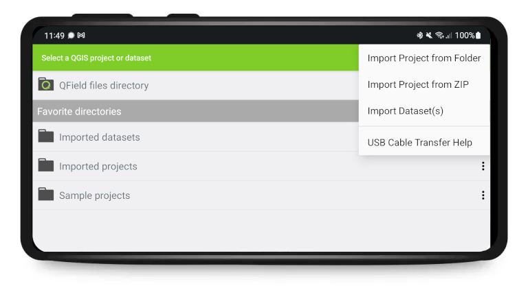
Practically, this means that instead of being shown and having access to the full storage tree when clicking on the “Open local files” button, users are now shown a set of new folders named ‘QField files directory’, ‘Imported datasets’, and ‘Imported projects’ as well as a drop-down menu accessible via a top-right three-dot button.
The drop-down menu lists the means to import projects and datasets: import project from folder, import project from ZIP [archive], and import [individual] dataset(s).
Import project from folder
When importing a project from a folder, users will be asked to grant permission for QField to read the content of a given folder on the device’s storage via a system folder picker. When the folder is selected, QField copies the folder content (including its sub-folders) into the app’s ‘Imported projects’ location. Users can then open the project from there.
Re-importing a given folder through the drop-down menu action will overwrite preexisting projects given an identical folder name. That allows users to be able to update projects.
Note that feature editing, addition, and deletion will be saved into the imported project’s datasets, not in the original folder selected during the import process. More on how to find and handle those project datasets will come later in this post.
Import project from ZIP archive
Having to adapt to Google’s new set of rules did not come without its benefits. Users can now easily transfer projects into a given device by compressing the project content into a ZIP archive and having QField import that compressed project automatically. This can greatly ease remote deployment of projects by being able to send a single file to users.
Import dataset(s)
QField can also import individual dataset(s). Users will be asked to select one or more files via a system file picker, which will be copied into the ‘Imported datasets’ folder. Users will have to ensure that all sidecar files are selected when importing (e.g. a shapefile dataset would require users to select the .shp, .shx, .dbf, .prj, and .cpg files).
Just like imported projects, editing of datasets will be saved into the imported datasets, and not reflected in the original files.
Alright, but how can I retrieve modified projects and datasets?
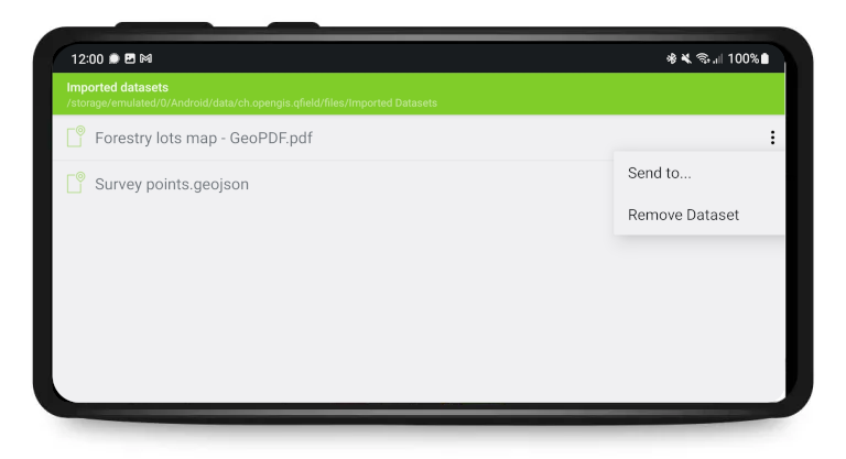
Imported projects and datasets can be accessed directly using a USB cable. The location on storage is displayed in the top navigation bar when opening a local file.
On most devices plugged into a computer via USB cable connection, the path will be <drive>:/Android/data/ch.opengis.qfield/files/ where you will find both the Imported Datasets and Imported Projects folders within which your edited content will be located.
However, we’ve also added a nice new ‘Send to…’ functionality that allows for users to share and send datasets straight from QField using Android APIs. This allows for the sending of edited datasets directly to third party apps (Gmail, Drive, Dropbox, Nextcloud, your favourite messenger app, etc.).
Is direct copying via USB cable gone altogether?
Users can still avoid going through the import process by copying files via a USB cable connection directly into the QField app’s files directory. As mentioned above, the location on most devices will be <drive>:/Android/data/ch.opengis.qfield/files/.
What are the benefits from these changes?
Working out a functional solution to meet Google’s newly-enforced restrictions did not come without its benefits.
On top of what was already covered above – importing of compressed project ZIP files and sharing functionalities – QField is now fully integrated with Android’s cross-application document sharing APIs. This means that users can now directly open projects and files sent to them via their favourite browser/email/cloud/messenger app without the need to first download those files onto the device.
Altogether, the newly-coded importing mechanisms and integration with Android document APIs don’t only improve the ease of use for the average person, it also makes viewing and editing spatial datasets on QField far more secure. The imported projects and datasets reside in a location with access limited to QField only, meaning that its content is inherently far more protected from malicious access from third-party apps.
Why were these drastic changes needed?
As mentioned in the introduction, the changes were needed to comply with a set of new Google Play policies that came into force in November 2021. Users can read more on Google’s rationale on this page https://developer.android.com/google/play/requirements/target-sdk.
As part of the enforcement of these new policies, Google came up with an arbitrary mechanism to whitelist some apps which allows those to retain full storage access given the user explicitly allowed for it. We here at OPENGIS.ch believes QField had ample justifications to be whitelisted, however, Google’s appeal process judged otherwise after a series of email exchanges detailing our reasoning. While we have so far lost this argument with Google, we will continue fighting for our users and for their freedom to choose. If by any chance you have a good contact at Google that might be willing to listen to our reasoning, we would be grateful if you’d get in touch with us.
We hope this clarifies the recent changes and helps QField users adapt to those.
For once, it’s not an app from the Silicon Valley, but from Laax in the Swiss Alps that made the news. By publishing QField as an open-source app, OPENGIS.ch allows companies, organisations and even countries without the necessary financial means to have the opportunity to benefit from this important data collection app. And it is being used: Over half a million downloads have already been achieved. Now, since the volcanic eruption in Tonga on 15 January 2022, the app of the small Laax-based company is playing a not-unimportant role in disaster response planning.
We’ve only been around for seven years. We could almost pass for a start-up. But OPENGIS.ch is already a household name when it comes to field data collection. OPENGIS.ch makes its field mapping tool QField available without restrictions (i.e. open-source) so that companies or even nations can collect their geographical data. In this way, data is brought from the field to the office and provides important insights for future decisions.
This was also the case for Tonga’s volcanic eruption. There, in December 2021, many relevant agricultural datasets were captured with “QField” and “QFieldCloud”. This currently helps the Ministry of Agriculture, Food, Forests, and Fisheries to analyse the damage after the volcanic eruption and the subsequent tsunami and plan the response.
Swiss software in use for Tonga
It is a technical and ethical decision for me. I want not only the privileged nations to benefit from our work.
Marco Bernasocchi, CEO
Co-founder Marco Bernasocchi’s credo is to focus on further developing the product (QField). OPENGIS.ch makes it freely available, so that nations like Tonga, with little financial means, can use professional software and invest their financial resources in reconstruction. “It is a technical and ethical decision for me. I want not only the privileged nations to benefit from our work. We are always developing the product and generate income mainly from support, paid developments and custom solutions. Our product, however, is publicly accessible”. This strategy is successful: the company is 90% financed by Swiss customers but the app is used all over the world. “Open source is a technological advantage for me. This way we get the input of many developers worldwide who are motivated to work out the best possible software. This leads to a superior product and is particularly valuable to me.,” adds Matthias Kuhn, co-founder of OPENGIS.ch.
This way we get the input of many developers worldwide who are motivated to work out the best possible software.
Matthias Kuhn, CTO
John Duncan, project manager at the University of Western Australia, who is working on the project in support of Tonga, explains the work done in December like this: “the workflow uses QField to map the extent of landscape features including agricultural fields and cropped holdings, recording detailed attributes about each feature’s farming system. QFieldCloud was used to support large teams of data collectors tasked with surveying every tax allotment across Tonga. The initiative has resulted in the detailed mapping of cropping and livestock systems for over 11,000 farms across Tonga’s three main island groups. These datasets provide actionable information for short-term decision making around food security, agricultural planning, and disaster response, and are a valuable resource for longer-term monitoring of agricultural and environmental changes in these climate-vulnerable locations.“
The data was originally intended for food security and agricultural planning. But now they suddenly have acquired enormous value and can be used for disaster response planning.
John Duncan, University of Western Australia
Further information on QField in connection with Tonga:
OPENGIS.ch GmbH is a Swiss software development company based in Laax. OPENGIS.ch employs 19 people and works mainly in the field of spatial software development, geodata infrastructure deployments and professional support. Personalised open source GIS solutions are often planned and developed as desktop or mobile applications. OPENGIS.ch finances itself through tailor-made customer solutions, professional support and adaptations. Link: https://opengis.ch
OPENGIS.ch team in Summer 2021 company retreat
About the OPENGIS.ch product “QField” application
“QField” is an open-source app developed for efficient fieldwork in real-time in urban areas, with 5G connection or with offline data. The mobile GIS app combines a minimal design with sophisticated technology to conveniently bring data from the field to the office. Seamless QGIS integration, GPS centred, offline functionality, synchronisation capabilities, desktop configurable: “QField” is designed for fieldwork – simple but uncompromising. Link: https://qfield.org
About the OPENGIS.ch service “QFieldCloud“
“QFieldCloud” is a spatial cloud service integrated into “QField” that allows remote provisioning and synchronisation of geodata and projects. Although “QFieldCloud” is still in an advanced beta stage, it is already being used by many groups to significantly improve their workflows. Link: https://qfield.cloud
Today, on QField’s 10th anniversary, we’re extremely proud to publish the results of over 18 months of development and give you the source code of QFieldCloud to go and make your awesome adaptations, solutions, and hopefully contributions
If you want to quickly try it out, head to https://qfield.cloud where our hosted solution is running and secure yourself a spot in the beta program.
QFieldCloud’s unique technology allows your team to focus on what’s important, making sure you efficiently get the best field data possible. Thanks to the tight integration with the leading GIS fieldwork app QField, your team will be able to start surveying and digitising data in no time.
What a journey it was and what plans do we already have… It has now been 10 years since I pushed the first scripts to build Quantum GIS for Android and it is incredible what we’ve been able to achieve thanks to a vibrant community, sponsors and especially our fantastic team.
At OPENGIS.ch we strongly believe in giving back. We live from open-source projects and are deeply committed to sustaining their technological and economicwell-being. We also believe everyone should have access to the best possible tools and knowledge. By committing ourselves to develop open-source applications, we give everyone access to powerful tools to plan, review and mitigate geospatial issues.
That is why we are even more thrilled to have created and open-sourced a professional data and team management solution for the best QGIS fieldwork app and would like to share a bit of the history of how we revolutionised field work by creating QField for QGIS.
Prehistory – QGIS for Android is born
Stone-, bronze-, iron-age, you get it, the beginnings of field mapping in the QGIS world were pretty rough around the edges. It all started thanks to me being accepted in the Google Summer of Code 2011 programme with the “QGIS mobile” submission. In the following 3 months, I’d try, with the help of my mentors Pirmin Kalberer and Marco Hugentobler, to get Quantum GIS to run on my tablet.
The first start
Hi all, it is a pleasure to announce that I finally got Quantum GIS to start on an android (3.2) tablet (Asus transformer). I tested as well on a Samsung Galaxy phone with cyanogen mod 7 RC1 and it works well (with the obvious screen size limitations). Qgis still doesn’t load many elements, but the GUI is there and the rest should be only minor issues. I’ll post more as soon as I make further developments. Meanwhile, if you want to test the apk, you can download it from my GitHub here. For building your own, have a look at qgis wiki
See my last posts. In short, I managed to get qgis packaged as an APK and to properly run with only one major problem. The map canvas is always black. I’ll investigate this till Tuesday. Cheers
After 3 months of intensive work, QGIS for android finally has a a proper GUI
Blazing fast startup
Hi, I just managed to create an APK with all the resources needed by qgis …
The only inconvenience at the moment is that at the first startup the app shows a black screen while it’s copying the files for about 30 to 60sec so just be patient and remember that the whole app will take up to 230MB (it installs on external storage by default)
I still remember the feeling that day when after almost 3 months, of fighting with shell scripts, patching of build systems, debugging via ADB, writing C++ in Java wrappers and so on, my Quantum GIS test project was suddenly running on my tablet… I Was so happy I just went running in the mountains :).
Just a quick screenshot to show that qgis on android is now a working reality. Tomorrow I’ll make a video and so on. The major missing thing now is reading SHP files ad maybe spatialite… maybe tomorrow. Now it’s Sunday
At the end of the Google Summer of code, I received my MSc in geoinformatics and left for 3 Months to Indonesia working as a consultant/developer for the World-bank Global Facility for Disaster Reduction and Recovery.
So, it is over, after 3 months of working on QGIS for android as a Google Summer of Code project it is now time to wrap up what I did and didn’t do. First of all a QGIS android app exists now and it has many features including: – reading/writing projects – raster support – spatialite support – WMS support – (apparent – untested) WFS and Postgres support – partial shape files support (string attributes still crash the app) – Fully functional GUI (SymbologyV2 doesn’t work yet) – (all?) core C++ plugins beside globe (any takers? ) Furthermore, I created a series of build scripts that make it easier to set up a dev environment. Unfortunately, I didn’t manage to implement live GPS tracking and a larger GUI optimisation, but all in all, I’m very happy with the results and seeing that few peoples are already testing it. Soon ill publish a video. cheers
Quantum GIS for Android was a reality and I was fully committed to keeping working on it. Turns out I wasn’t wrong
A commitment is a commitment
Classical – QGIS for Android grows
The Next Era of QGIS for android is what could be seen as the time of great knowledge enhancement, philosophical musings and the rise of the first great features including:
The dark ages, times of instability, change and some setbacks. Sounds terrifying, it was not at all, on the contrary it was a very formative period that apexed with the fantastic release of QGIS 2.0 for android.
The QML app experiment
From the beginning on, the idea behind QGIS for android was to eventually ditch the GUI and build a dedicated one for touch devices. The code for the future.
UX mockup for the first QML based app
UX mockup for the first QML based app
UX mockup for the first QML based app
Screenshots of the first QML based UI
The Python failure
Probably the major setback in QGIS for android’s history was the non-completion of the Python support. I got really close to it multiple times but unfortunately never managed to tame the snake. Maybe something we’ll look into in future, who knows.
The pivotal point of the Middle Ages was definitely 20.09.2013, when Tim Sutton presented to a full auditorium the shiny new QGIS 2.0. And along with it it introduced the general availability of QGIS 2.0 on android. The first real QGIS version for mobile devices was finally available for the broad public.
Tim Sutton announcing QGIS 2.0
Tim Sutton announcing QGIS 2.0 for Android
QGIS 2.0 general availability for Android
After the launch followed a very active time of keeping QGIS for Android on pair with the desktop versions leading to a regular release of updates on the playstore between 2013 and late 2014. This is also when Matthias Kuhn started committing to the QGIS for Android repository.
Early Modern – QField for QGIS is here
Humanism, Renaissance and Enlightenment are what we saw happening in the period between 2015 and early 2019. Field users were put at the centre of the design process, new ideas were explored and a new name was chosen to reflect the main goal of the application: Make fieldwork as efficient as possible.
Early 2015 was also when Matthias Kuhn and myself decided to join forces in OPENGIS.ch LLC.
The rebranding
The project never had a clear name, at times it was called QGIS for Android at times QGIS mobile, we felt that to clearly convey what we were building we needed a clear, simple and poignant name.
Beginning of 2015 saw the last rebranding
It is with great pleasure that we want to announce the new name for what was briefly known as QGIS mobile.
Please welcome QField for QGIS!
After long thinking about various names and variants including QGIS mobile, QTouch, OPENGIS.ch QGIS mobile, QWork, and many more, we felt that QField represents best what we want to archive. A field data capture and management app fully compatible with QGIS.
QField Experimental is out, after a couple of months of requirements gathering, private early alpha testing and foremost tons of emails requesting access to the testes group we decided today to put the current BETA version in the playstore.
Since the beginning of QGIS for android, to distribute the needed Qt libraries, we used a project called “ministro”. This was interesting because it allowed to download the libraries only once but on the other hand, it was a very painful experience for the user that needed to install a second app before getting QField to start. Around the end of 2015 it was so far, we finally managed to get rid of that dependency and make the installation process as streamlined as possible.
It’s done, finally we managed to get rid of Ministro so that we finally can say, QField runs on any android from 4.0.3 (ICS). This makes as of today (according to google) 96% of the android installations worldwide.
In these 3.5 years, a continuous, mainly volunteer-driven iterative process led by Matthias Kuhn made QField grow to the point where we felt confident it was time to launch QField 1.0.
After a series of release candidates with lots of feedback from the community, we felt it was time to move into a New Era.
It was a long and winding road but we are very excited to announce the general availability of QField 1.0 Release Candidate 1.
Packed with loads of useful features like online and offline features digitizing, geometry and attributes editing, attribute search, powerful forms, theme switching, GPS support, camera integration and much more, QField is a powerful tool for those who need to edit on the go and would like to avoid standing in the swamp with a laptop or paper charts.
We are incredibly pleased and proud of just having released such a jewel and are convinced that thanks to all its features and conscious design choices, QField will make your field digitizing work much more efficient and pleasant.
In the last 2 years the development pace increased tremendously, the sponsored featured grew as never before, QField rating skyrocketed to 4.7 we currently have 100’000 active users and we’re getting around 500 new users every day.
Our QField core team grew more and now thanks to David Signer’s lead and Mathieu Pellerin keen eye for UX we’re pushing QField even further.
Going into all releases would be so much information that this post would turn into a 3 volumes classic, and since starting from QField 1.0 we’ve documented each new release, we’re just going to link them: https://www.opengis.ch/category/qfield/highlights/
The future is cloudy – ehm sunny of course
Yesterday we published QField 1.9.6, which is going to be the last 1.X release and will put QField 2.0 into the beta channel so that every beta tester can start using QFieldCloud without having to use the developer version.
But that is a different story and you can read all about it in our latest newsletter…
Get fieldwork smoothly and nimbly done despite the ice and snow outside. Collect accurate data with freehand digitizing and improved form widgets, use the data from your external GNSS receivers without any third-party apps and enjoy the pleasant usability of QField 1.8 Selma.
This year started off hi-speed for us. There’s been already a lot of coding, designing and teaching, and we’ve thrown ourselves into these things we love to do. And we published another QField release last week that I completely forgot to announce in this blog. But here it is. It’s QField 1.8, Selma. And it’s packed with cool features.
Let’s have a look.
Freehand drawing
This might be a feature that brings a lot of fun and professionalism to your work. The freehand digitizing mode allows the user to “draw” lines and polygons with the stylus pen. The mode is available for adding line/polygon features as well as for the ring tool of the geometry editor.
Together with the powerful options in the topological editing where you can snap to existing features and avoid overlaps, it’s very convenient to digitize complex shapes.
Zoom in and out
Speaking of fun. One day, a guy from the QGIS community asked us if we could implement the functionality to zoom in and zoom out like he is able to do with an app called Maps from a company named Google. I didn’t know what he meant, but he explained: Single finger double tap-and-hold zoom gesture (which allows you to zoom smoothly from anywhere on the screen). Wow! Didn’t know it before, but it’s super neat! So we made it available in QField as well.
If you are used to it, it’s quite easy. But for beginners it can be a bit difficult. So for people who are not that deft – and to keep the UX self-explanatory and simple – we also added two buttons + / – to zoom in and zoom out with just one finger. So now even a clumsy pirate with a hook instead of a hand can collect data with QField
Powerful Relation Reference Widget
Let’s be a little bit more serious and talk about how powerful the relation reference widget has become.
View and Edit selected feature
The intuitive eye icon next to the widget lets you open the form of the referenced parent feature to view and edit it.
Autocomplete mode
When auto-complete is enabled, you can easily perform a search in all available parent features.
With space-separated input, you can search for the beginning of multiple words in the display name of the parent features. So in this example searching for “Ma” will find the name “Mae” and “Marie” and using the second word “buck” it finds the Buckfast bees – so the entries containing both values will be listed on top.
Integration of external GNSS receivers
In case you wondered, why we did not release 1.8 Selma earlier? Because we wanted to have it feature loaded and rocket proof. And one of this cool feature is the integration of external GNSS receivers.
QField can receive and decode NMEA sentences received via Bluetooth from an external GNSS receiver (such as an EMLID Reach RS2) without the need for any third party app.
Search for paired Bluetooth devices in the device settings, connect to the external device and receive the GNSS information.
Select vertical grid shift files
In the QField settings, you can select a grid file on your mobile device by placing it in a directory named QField/proj in the main folder of the internal storage to increase the vertical location accuracy.
Postgres Config File
If you once started using PostgreSQL configuration files, you don’t want to live without them anymore. And when you use it on your PC, I’m sure you want to use it on your mobile device as well.
Define Postgresql services in a pg_service.conf file and use it on QField by placing it directly in a directory named QField in the main folder of the internal storage.
Add reload data button
The layer properties have been polished and in addition, you will find a button to reload the layer data. This is especially useful if you use WFS layers from which you need to get updates.
Register extra fonts
Also, you can add TTF and OTF font files into a directory named QField/fonts at the main folder of the internal storage to use the nice fonts you like.
How beautiful is that!
Support of new raster file formats
By the way: Many new raster file formats are supported – most notably COG. While not yet supported as remote format streamed directly from the web, it is also a high performance format if used locally
What about the cloud?
You might be one of these people eagerly waiting and always receiving the same message: Keep calm, it’s coming soon. Sorry for that. But when we do something, we do it right. And we prefer to have a stable solution than to publish half baked stuff. We are still highly busy coding, testing and promoting QFieldCloud. It’s announced for this spring / early summer.
The Beta Testers are our secret heroes. They report bugs and inconveniences before the normal users are bothered with them. Thanks to the Beta Testers QField is so stable. And at this point we would like to say: Thank you, test heroes!
And what do the beta testers get in return? Well, they can be the very first to try out the great new features. This is exciting and fun. So don’t hesitate. Join the beta.
In the Play Store you should find this section under the “QField for QGIS” app listing. Enjoy the feature frenzy and report the problems at qfield.org/issues
And if you wondered…
… why this release is called “Selma”. It’s of course because of the Mount Selma in Australia… And because it’s the name of my beloved cat. That’s her – Selma Eulenkopf – staring at me while I’m coding QField.
Be ready for the cold weather with a smooth coordinate search, filters in the value relation widget, fancy new QML and HTML widgets, enhanced geometry editing functionalities and an expandable legend. Right when Autumn starts, QField 1.7 Rockies hits the stage.
The days are getting shorter and the wind blows colder. It’s always good to be in a good company outside while getting your mapping work done. QField will be your reliable companion.
We know, QField 1.6 Qinling has only been out two months and with its amount of new features and stability improvements, it would have deserved a longer primetime. But we just couldn’t withhold you all the new great stuff we’ve been building lately.
So let’s welcome QField 1.7 Rockies. And yes, we mean THE Rockies, where QField is looking for plenty of new buddies.
Let’s have a look.
Merging features
Splitting of a feature has been possible for quite some time. Now the merging of features of multipolygon-layer is possible as well. Select them and merge them – easy like that. The first selected feature gets the new geometry and keeps its attributes.
Filters in the Value Relation Widget
The value relation widgets provide an easy selection of a related feature. Often it’s used for lookup tables but sometimes the related tables contain a lot of entries and the list of the possible values is long.
Using filters in the value relation drop-down can increase the efficiency in selecting the correct value. It can be configured by expressions in QGIS, so it’s possible to have the content of the drop down depend on the values entered previously in other fields.
In the screenshot above there is a Map Value Widget with “forest” and “meadow” as values. On selecting “forest”, only the trees appear in the Field “Plant Species”. On selecting “meadow” there would be listed flowers instead.
Go to coordinates in the Search
The search has not only been improved in its appearance, but it’s handling is much more comfortable with a button to clear the text and easy opening and closing.
Additionally, we added the possibility to jump to coordinates. Searching a place you know the coordinates of is now super simple. And this means that digitizing that precise geometry with known coordinates is finally possible.
QML and HTML Widget
You might remember when we introduced the QML widget in QGIS. Now it’s in QField as well. And it’s not alone. HTML widgets are supported too.
This provides a lot of possibilities to display information with texts, images and charts and it even allows you interaction. Do you need help setting up complex forms? Don’t hesitate to get in touch with us!
Expandable legend icons
The legend items are now expandable and collapsible.
Wait a minute… Wasn’t this possible before? Yes. It was possible in earlier versions. But why it’s announced here as a new feature?
Some technical background: As you may be aware QField uses QGIS under the hood and QGIS uses Qt under the hood. Qt is currently used in version 5. Qt 5 is not that young any more and has a lot of functionality which is no longer supported by Qt. The old legend was based on the tree view, a deprecated module. Using it had some implications like the suboptimal support of HiDPI. Furthermore, these deprecated modules will disappear in the soon-to-come Qt 6.
As you can see, keeping QField at the quality we and you expect requires a lot of maintenance work. It is of utmost importance and only possible thanks to sponsoring since paying for fixing already existing features is less attractive for most people.
What will the future bring
In the last weeks, we have been highly busy on coding, testing and promoting QFieldCloud and we are very happy to be able to announce it very soon. So be prepared.
QField is an open source project. This means that whatever is produced is available free of charge. To anyone. Forever. This also means that everyone has the chance to contribute. You can write code, but you don’t need to. You can also help translating the app to your language or help out writing documentation or case studies or by sponsoring a new feature.
And now…
… enjoy QField 1.7 Rockies and have a nice autumn!
Editing multiple features at the same time, support for stylus pens, dynamic configuration of image names and much more. QField 1.6 Qinling 秦岭 comes packed with awesome new features and an improved user experience.
We have been very busy over the last few months working on a new and shiny QField release. We have added many new features that increase efficiency on the field or allow for new workflows. In parallel, we have also been working on ironing out a series of issues and improving the overall user experience to make the app as pleasurable to use as possible. The result is QField 1.6 which has been published now.
Enough of the highlevel talking, let’s see what has been done.
Multi editing
Do you recall Geography lesson 101, Toblers first law? Everything is related to everything else. But near things are more related than distant things.
Very often there are similar objects nearby which share a property, tree species tend to group, human created objects like street light types or street paint markings tend to be of the same type at the same location.
With QField 1.6 it is now much easier to select a couple of features and change an attribute with very few taps. Identify a feature, long press an identify results, select more features and click the edit attributes button.
Stylus support
Sometimes it is just too cold to be working with fingers (although of course you can get capacitive gloves too). Or you just prefer to be working with a pen. QField 1.6 comes with support for stylus pens. If your device ships with one, give it a try.
Lock geometries
For some scenarios, especially in asset management, you only need to change attributes of existing objects and never add new features, delete features or change geometries. This can be configured through QFieldSync and set in the layer properties.
Image name configuration
Did you ever want to have the file names of your pictures to match the feature id, the layer name or any free text? The expression based configuration in QFieldSync offers now complete freedom in naming your images.
Legend and UX and legacy code
Didn’t expect to read UX and legacy code in one single title?
QML is the technology on which the QField user interface is built. QML ships a lot of user interface elements in a library called “Quick Controls”. A long time ago already it received an update from version 1 to version 2. Up to recently we still have been using some elements from version 1, which had an effect on high resolution displays not being able to properly display everything. To workaround that we introduced a lot of band aids, to improve the situation. We are very happy, that by migrating the legend and few other remaining elements to Quick Controls 2 in version 1.6, we have been able to completely drop this code.
Topological editing
QGIS can detect shared boundary by the features, so you only have to move a common vertex once, and QGIS will take care of updating the neighboring ones. So does his little college QField since this release.
Fast editing mode
For the real adventurers who know what they are doing this release brings the fast editing mode. In this mode, the features will automatically be stored on every change. The user interface is lighter and it combines perfectly with the topological editing.
Unter the hood
We have brought the whole technology stack up to speed with modern requirements. Proj and GDAL have been updated to recent versions. This helped to mitigate a couple of issues with coordinate transformations that were completely misplaced. It also paves the path for a future with datum corrections and always more important high precision measurements.
Known Issues
Unfortunately, we are experiencing a crash on startup with 32 bit devices. These devices are not that common any more, but if you have a device that is already a couple of years old it’s very well possible that it comes with a 32 bit cpu builtin. Despite the team’s hard efforts to isolate the reason, we were not able to find out what it was yet. Because of this we will not be able to update to 1.6 for these devices at the moment. We still hope that we will find a solution for this but don’t know yet when this will be.
We have updated proj to version 6. This brings plenty of bug fixes with coordinate handling. Among other things it adds support for using datum grids (gsb files) for very precise transformations, it is not yet possible to install those on the device. You will get an information message in the about dialog if your project happens to fall into this category. In this case, as a workaround switch the CRS of the project to a CRS with a known conversion that works without grid files.
What will the future bring
You guessed it already, we are not tired and have plenty of things stacked for the future. Prepare for more exciting updates for attribute forms and also for QFieldCloud which is right now being tested in our R&D labs.
QField is an open source project. This means that whatever is produced is available free of charge. To anyone. Forever. This also means that everyone has the chance to contribute. You can write code, but you don’t need to. You can also help translating the app to your language or help out writing documentation or case studies or by sponsoring a new feature.
Thanks to sponsors
Various organisations have helped to make this new release become a reality. Without the support of people in organisations who believe in the future of QField and open source tool for geospatial in general. The whole team behind QField would like to thank you with a big applause!
What a year’s start! After a very packed December publishing all the QGIS on the road videos and quietly releasing QField 1.3 – Ben Nevis we could have gone and relaxed over the holidays. But since we love QField so much we immediately started working on the next iteration. Now, after an intensive testing period, we are proud to announce the release of QField 1.4 – Olavtoppen.
Olavtoppen!? yes, the highest point of Bouvet Island, the remotest island on Earth. And sure enough, QField would follow you there!
Before digging into all the new goodness that you will find in QField 1.4, let’s get a big “Thanks” out to everybody who supported our crowdfunding campaign for improved camera support and all our customers that agreed to open source the work we did for them.
If you like QField, want a new feature or would like to support the project, don’t hesitate to get in touch with us.
Usability enhancements
In QField 1.2 we started to improve on the usability of the user interface. We are constantly working on this with a usability expert to get the user interface to be even more appealing and user-friendly.
Besides lots of clean-up and polishing, QField received two major improvements, a portrait mode and a new welcome screen with recent projects.
Welcome screen with recent projects
QField is all about efficiency. While favourites folders in the file selector already give a great productivity boost, very often we work with the same 3-4 projects. This is why we redesigned the welcome screen to list the last five project used. And if you look carefully you might get a hint of what will be coming soon…
Portrait mode
QField now flawlessly works in portrait mode. We heard you say you needed a comfortable way to work in portrait mode, especially on smartphones. QField forms and button placements are now optimized to be easy to use with your thumbs.
Optimised forms
Buttons align at the bottom
Roomy legend
New features
We keep on listening to your feedback and prioritize new features based on it. We did implement some minor features like allowing hiding legend nodes and printing to PDF using the current extent. But this time’s superstars are three highly expected features: Splitting of geometries, compass integration and, yes you guessed right, native camera and gallery app support!
Split Features
A new editing tool is available that allows for splitting existing features. This adds an even more powerful operation to an already impressive geometry editing tools set.
Compass integration
A long-awaited feature! QField now shows you on-screen in which direction you are looking, walking, driving, flying or warping direction. This makes it much easier and more pleasant to navigate in the field.
Native Camera and Gallery
It is now possible to use your favourite camera app so that you have more control over how pictures are taken. It is also possible to select pictures which are already on your device by using the new gallery selector.
Pro Tip: You can use any camera app. For example, you can use the open camera app to create geotagged photos if your preinstalled system camera doesn’t save positioning information in EXIF data.
Pro Tip 2: You can use an image annotation app to add notes, sketches, drawings and so on to your images and then choose them from QField via the add from gallery button.
Antenna Height Correction
For high precision measurements, it’s possible to compensate your altitude by a fixed antenna height. This will then automatically adjust all the digitised altitude values.
JPEG 2000
Support for JPEG 2000 raster datasets was added. This lossy format offers a compression rate at par with proprietary formats like ECW or Mr SID.
Pro Tip: save your base maps in JPEG 2000 to save storage.
New Languages
Thanks to the hard work of our community, QField is now also available in Turkish and Japanese.
New packages
You say: wow that’s a lot! We say: there is more We have upgraded our whole building infrastructure so that you can comfortably get even more QField goodness without having to uninstall your production ready QField.
Automated master builds
After each pull request is merged into our master code, a new package is created and automatically published on the playstore in a dedicated app called QField for QGIS – Unstable (Early Access). Installing this app will allow you to always have the latest build of QField for testing and giving feedback. On your device, this app is completely separated from the production-ready QField and has a distinctive black icon so that you do not confuse it.
Pull request builds
QField is an extremely active project, and as you see we develop multiple functionalities and fixes at the same time. If you’re particularly interested in one of this, our continuous integration fairy builds and publishes new packages automatically at each commit directly to the pull request you are interested in. To see what we are currently working on, have a look at the pull request overview page.
Experimental Windows builds
Last but definitely not least, we’ve set up an Azure CI infrastructure to build QField for windows. For now, we still consider this experimental but we already had some very successful testing. If you are interested in testing out QField for windows you can get it here, remember it is experimental so don’t use it in production yet and give us as much feedback as possible
What’s next?
As you can imagine we’ve had a very busy start of 2020, but even more is to come soon with the next releases of QField. We’d like to thank again all companies and individuals that actively use QField and that invest in making QField even better. If you feel QField misses something you need or would like to support the project, don’t hesitate to get in touch with us.
We would like to use WMS offline on QField. For that, we need to figure out what is the best way to get a raster from a WMS and which format is the most efficient (size and performance).
In this post we’ll show you is how to generate the ideal raster file from a WMS and the results of our efficiency tests for the the different raster formats.
WMS to GPKG
The simple way
If there is no limitation on the WMS or you need only a small region, here is the easiest process.
If the command takes too much time, it means that it is trying to download too much data and could be caused by downloading higher resolution data than required. The command might even completely fail if it contains a request for bigger data blocks thant the server allows.
Here is the process to get larger datasets in a simple way. Let’s use a real example:
Use gdal_translate "WMS:https://www.gebco.net/data_and_products/gebco_web_services/web_map_service/mapserv?request=getmap&service=wms&crs=EPSG:4326&format=image/jpeg&layers=gebco_latest&version=1.1.0" test.xml -of WMS
Open the test.xml file for editing, here you’ll find the parameters of the WMS. We change the “SizeX” to 3600 and “SizeY” to 1800. By changing these parameters we lower the resolution. It is important to keep proportionality.
Another thing we need to change are “BlockSizeX” and “BlockSizeY” that define the size of the tiles. We change both to 2048.
Finally, use gdal_translate -of GPKG test.xml test.gpkg -co TILE_FORMAT=JPEG
To make a Geopackage pyramid use gdaladdo GPKG:test.gpkg:gebco_latest. It will replace the Geopackage, if you want to keep the original one, you need to copy it first.
Now you have a raster Geopackage that you can use in QField.
Testing raster formats
Preparing the files
As first step we exported our test orthophoto WMS to a plain GeoTIFF using QGIS’ default behaviour.
Default parameters used to create the initial tiff
We have tested many formats, here is a table with the results of the size and rendering speed in QGIS and QField. To analyze the speed we used qgis_bench.exe -i 10 -p "C:\test\test.qgs" >> "C:\test\test.log. Qgis_bench is a tool that renders a QGIS project a number of times to get performance measurements. The parameter -i is to define the iterations and -p is the project used which contains only the generated raster.
Format
Extent [m]
File size [GB]
Total_avg
Total_maxdev
Total_min
Total_stdev
gpkg JPEG
52’880/29’230
0.4
250.242
255.781
5.539
244.984
gpkg PNG
52’880/29’230
2.9
412.002
490.328
152.142
259.859
gpkg PNG_JPEG
52’880/29’230
0.4
250.125
256.875
6.750
245.172
gpkg PNG8
52’880/29’230
1.4
283.875
296.406
12.625
271.250
gpkg WEBP
52’880/29’230
0.3
330.238
348.109
73.534
256.703
gpkg pyramid_JPEG
52’880/29’230
0.5
1.009
3.406
2.397
0.688
gpkg pyramid_PNG
52’880/29’230
3.0
1.208
3.281
2.073
0.688
gpkg pyramid_PNG_JPEG
52’880/29’230
0.6
1.491
4.344
2.853
1.016
gpkg pyramid_PNG8
52’880/29’230
1.6
1.508
4.375
2.867
0.969
gpkg pyramid_WEBP
52’880/29’230
0.4
1.333
4.906
3.573
0.766
JPEG2000
52’880/29’230
1.1
13.888
136.109
122.222
0.219
COG DEFLATE
52’880/29’230
3.6
264.427
273.094
25.411
239.016
COG_JPEG
52’880/29’230
1.0
14.778
131.172
116.394
1.734
tif
52’880/29’230
6.4
2.367
6.734
4.367
1.672
MBT
52’880/29’230
4.4
0.469
4.641
4.171
0
Comparison of file size and rendering speed of different raster formats. “Total” columns are rendering times in [s]. Lower file size is more storage friendly, lower Total_avg is more performant.
Analysis
File size
The Geopackage WEBP (with and without pyramid) has the best result for file size, but it is not yetsupported by QField (from 1.6) and is only slightly smaller than the JPEG variant.
Plain GeoTiff, MBTiles, Cloud Optimized GeoTIFF (COG – DEFLATE mode) and Geopackages with PNG generate by far the largest file sizes (up to 20x larger) and are thus not recommended.
Rendering speed
MBTiles are on average double as fast as JPEG Geopackages with pyramids which in turn are more than double as fast as GeoTIFF and 15x faster than COG. Geopackages without pyramids are 200 to 400 times slower.
Conclusion
Even though MBTiles render faster than the Geopackage pyramid JPEG, they come with an almost 10x bigger storage requirement which makes us say that the best offline raster format supported by QField is Geopackage pyramid JPEG or if you need transparency and slightly smaller files Geopackage pyramid WebP.
If you need transparency before QField 1.6, the best results are achieved with Geopackage pyramid PNG_JPEG.


 !
!


 we currently have 100’000 active users and we’re getting around 500 new users every day.


 our Beta Testers


