


QGIS server 3.28 is officially OGC compliant
QGIS Server provides numerous services like WMS, WFS, WCS, WMTS and OGC API for Features. These last years, a lot of efforts were made to offer a robust implementation of the WMS 1.3.0 specification.
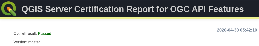
We are pleased to announce that QGIS Server LTR 3.28 is now certified against WMS 1.3.0.
This formal OGC certification process is performed once a year, specifically for the Long Term Release versions. But, as every change in QGIS source code is now tested against the formal OGC test suites (using OGC TeamEngine) to avoid any kind of regressions, you can always check any revision of the code against OGC failures in our Github continuous integration results.
All this has been possible thanks to the QGIS’s sustaining members and contributors.
QGIS Server and OGC API Features
Based on text and information from Paul Blottiere and Alessandro Pasotti (both QCooperative)
QGIS Server implements a number of OGC services, such as WMS, WFS, WCS or WMTS and extends these services where useful. Thanks to the efforts of a number of QGIS Server developers and companies, QGIS 3.10 (and 3.4 before) had been certified by the OGC for the WMS 1.3.0 service, and is also a WMS reference implementation.
![]()
Last year in 2019, a new protocol has been developed and named OGC API Features (commonly known as WFS3). With the purpose of having an up-to-date QGIS Server, both OSGeo and QGIS.ORG have dedicated funds to work on the implementation of this brand-new service: but we wanted to do it right, so the ambition was also to reach the OGC certification!
This new protocol with REST interfaces gets rid of the XML specification to use the OpenAPI standard as well as the JSON open format instead. In other words, it’s not just another protocol to support, but a whole package of changes and fresh mechanisms to work on. It was quite a challenge!
QGIS core developers of QCooperative were remotely participating in OGC sprints to closely monitor the development of the new OGC API Features protocol. Hence, we started its implementation and a fully operational version landed in QGIS Server 3.10.
Implementation and features
As a reminder, the WFS protocol allows to query, retrieve and manipulate vector features, unlike the WMS format which provides raster outputs. OGC API Features is the natural continuity and consistently provides basic mechanisms to retrieve features and corresponding information in a specific area (the famous GetFeatureInfo request in WFS 1.X).
In addition, QGIS Server also provides transactions for the OGC API Features protocol. This means basically that we can update, insert or delete features in the underlying data. And of course, everything can be easily reached and configured through QGIS Desktop.
Yet another interesting thing to note is also the full support of the date and time filtering. Nifty!
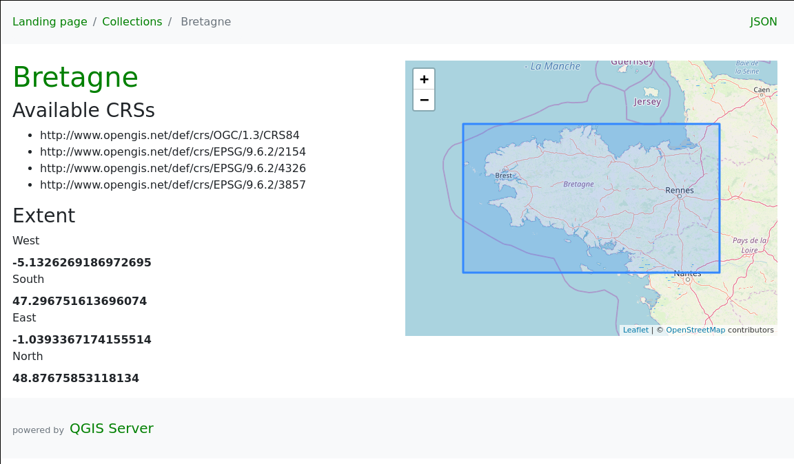
And last, but not least, QGIS Server 3.10 provides a default HTML template with an embedded map to explore the data served by the server. There’s literally nothing to configure, it’s just there as soon as you work with the OGC API Features protocol :).
OGC Certification
Once the implementation was completed, we started to address the OGC certification goal. To avoid unwanted regressions along the way, we first added nightly tests by updating the dedicated QGIS repository for OGC tests. From that moment, HTML reports are available day-to-day to monitor development over time.
Then, some bugfixes and backports later, we’re finally there: OGC tests are green on the development version, 3.12 and 3.10 releases. Yippee!
Conclusion
Now that everything is in order, the last step is to start the formal OGC certification process. From now on, the dedicated QGIS OGC Team takes care of further operations.
QGIS Server is ready for the new OGC API for Features protocol.
The new OGC API for Features (OAPIF) (also formerly known as WFS3) is one of the first protocols of the new generation of OGC web services and we are happy to announce that QGIS Server is ready to serve data following the specifications of this new protocol.
A lot of work has been going on during last summer to make sure QGIS Server was ready to support the new family of REST APIs, the underlying architecture allows in fact to expand QGIS Server API capabilities with any kind of new API that will be available in the future.
The new API is very similar to the well known WFS, but it also comes with a distinct set of features like content negotiations, REST actions, HTML templates, JSON as a first class citizen, self-documentation of the API (following OpenAPI specifications) and a preliminary implementation (the specifications are not yet finalized) of the simple transactions.
The new API is already in the QGIS Server documentation, it only misses the transaction part because the specifications are not yet final and we don’t want people start relying on an API that is probably going to change quite soon.
The vast majority of this new development has been possible thanks to the volunteer work of our core developers but we also wish to thank OSGeo and QGIS sustaining members and donors for funding a substantial part of the following activities:
| OPENAPI validation (completed) |
| Online demo (TODO) |
| CI validation/ OGC CITE (started) |
| Expose Schema (completed) |
| Simple Transactions (completed) |
| Returned fields filter (completed) |
| Documentation (completed except for transactions) |
| JSON performance comparison with WFS (TODO) |
| Time filter support (completed) |
Enjoy the new API and beware that this is only the first of a brand new series of OGC APIs that will make much easier for users to interact with data and for developers to create applications that consume those data.
Text provided by Alessandro Pasotti (QGIS core developer)
QGIS 3 and performance analysis
Context
Since last year we (the QGIS communtity) have been using QGIS-Server-PerfSuite to run performance tests on a daily basis. This way, we’re able to monitor and avoid regressions according to some test scenarios for several QGIS Server releases (currently 2.18, 3.4, 3.6 and master branches). However, there are still many questions about performance from a general point of view:
- What is the performance of QGIS Server compared to QGIS Desktop?
- What are the implications of feature simplification for polygons and lines?
- Does the symbology have a strong impact on performance and in which proportion?
Of course, it’s a broad and complex topic because of the numerous possibilities offered by the rendering engine of QGIS. In this article we’ll look at typical use cases with geometries coming from a PostgreSQL database.
Methodology
The first way to monitor performance is to measure the rendering time. To do so, the Map canvas refreshis activated in the Settings of QGIS Desktop. In this way we can get the rendering time from within the Rendering tab of log messages in QGIS Desktop, as well as from log messages written by QGIS Server.

The rendering time retrieved with this method allows to get the total amount of time spent in rendering for each layer (see the source code).
But in the case of QGIS Server another interesting measure is the total time spent for a specific request, which may be read from log messages too. There are indeed more operations achieved for a single WMS request than a simple rendering in QGIS Desktop:
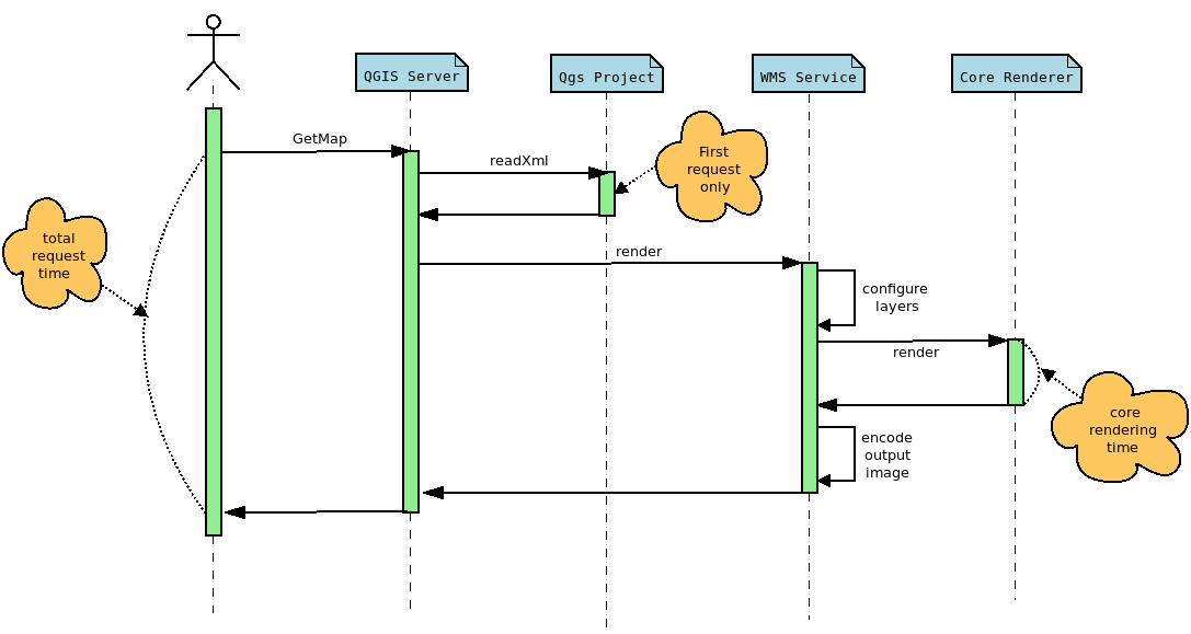
The rendering time extracted from QGIS Desktop corresponds to the core rendering time displayed in the sequence diagram above. Moreover, to be perfectly comparable, the rendering engine must be configured in the same way in both cases. In this way, and thanks to PyQGIS API, we can retrieve the necessary information from the Python console in QGIS Desktop, like the extent or the canvas size, in order to configure the GetMap WMS request with the appropriate WIDTH,, HEIGHT , and BBOX parameters.
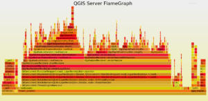
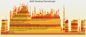
Another way to examine the performance is to use a profiler in order to inspect stack traces. These traces may be represented as a FlameGraph. In this case, debug symbols are necessary, meaning that the rendering time is not representative anymore. Indeed, QGIS has to be compiled in Debug mode.
Polygons
For these tests we use the same dataset as that for the daily performance tests, which is a layer of polygons with 282,776 features.

Feature simplification deactivated
Let’s first have a look at the rendering time and the FlameGraph when the simplification is deactivated. In QGIS Desktop, the mean rendering time is 2591 ms. Using to the PyQGIS API we are able to get the extent and the size of the map to render the map again but using a GetMap WMS request this time.
In this case, the rendering time is 2469 ms and the total request time is 2540 ms. For the record, the first GetMap request is ignored because in this case, the whole QGIS project is read and cached, meaning that the total request time is much higher. But according to those results, the rendering time for QGIS Desktop and QGIS Server are utterly similar, which makes sense considering that the same rendering engine is used, but it is still very reassuring :).
Now, let’s take a look to the FlameGraph to detect where most of the time is spent.
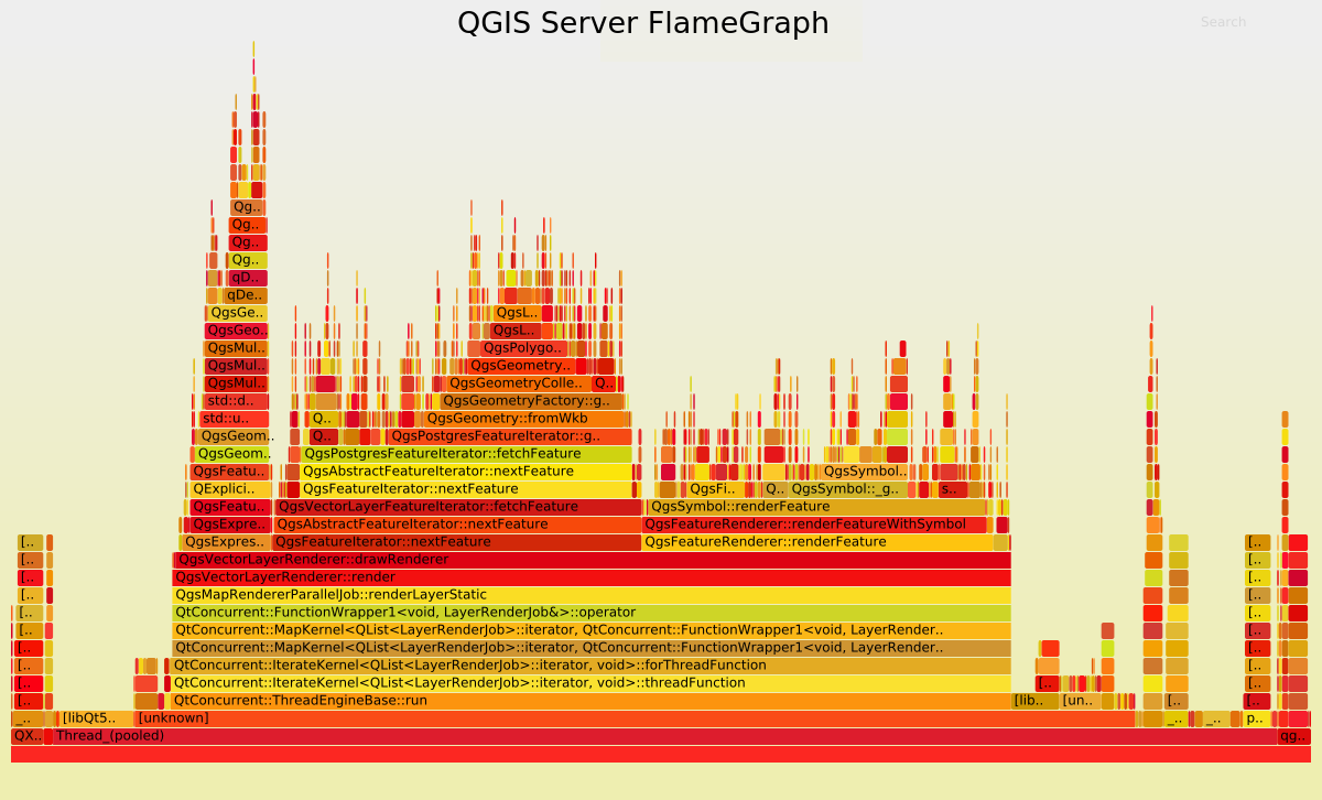
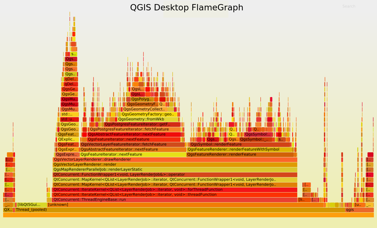
Undoubtedly the FlameGraph’s are similar in both cases, meaning that if we want to improve the performance of QGIS Server we need to improve the performance of the core rendering engine, also used in QGIS Desktop. In our case the main method is QgsMapRendererParallelJob::renderLayerStatic where most of the time is spent in:
| Methods | Desktop % | Server % |
| QgsExpressionContext::setFeature | 6.39 | 6.82 |
| QgsFeatureIterator::nextFeature | 28.77 | 28.41 |
| QgsFeatureRenderer::renderFeature | 29.01 | 27.05 |
Basically, it may be simplified like:
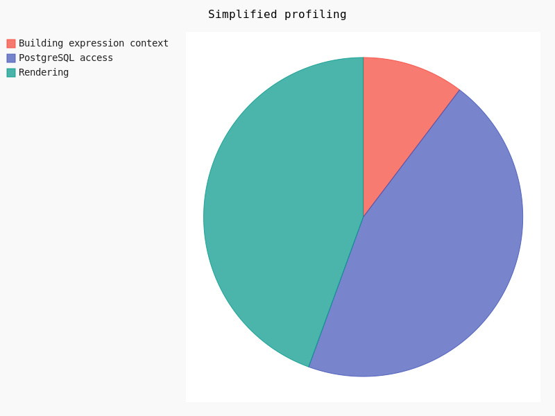
Clearly, the rendering takes about 30% of the total amount of time. In this case geometry simplification could potentially help.
Feature simplification activated
Geometry simplification, available for both polygons and lines layers, may be activated and configured through layer’s Properties in the Rendering tab. Several parameters may be set:
- Simplification may be deactivated
- Threshold for a more drastic simplification
- Algorithm
- Provider simplification
- Scale
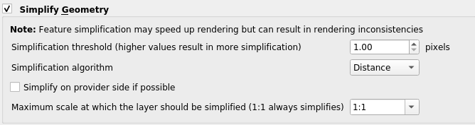
Once the simplification activated, we varied the threshold as well as the algorithm in order to detect performance jumps:
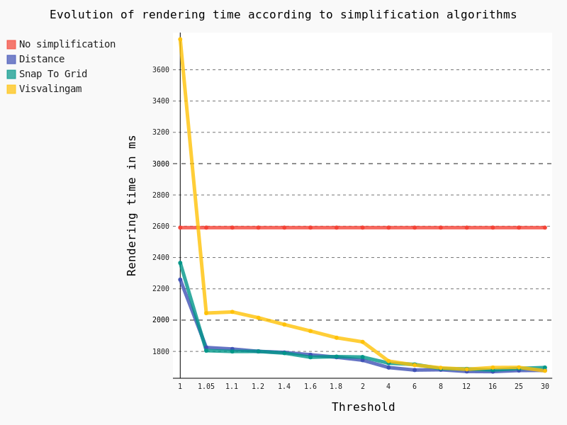
The following conclusions can be drawn:
- The Visvalingam algorithm should be avoided because it begins to be efficient with a high threshold, meaning a significant lack of precision in geometries
- The ideal threshold for Snap To Grid and Distance algorithms seems to be 1.05. Indeed, considering that it’s a very low threshold, the precision of geometries is still pretty good for a major improvement in rendering time though
For now, these tests have been run on the full extent of the layer. However, we still have a Maximum scale parameter to test, so we’ve decreased the scale of the layer:

And in this case, results are pretty interesting too:
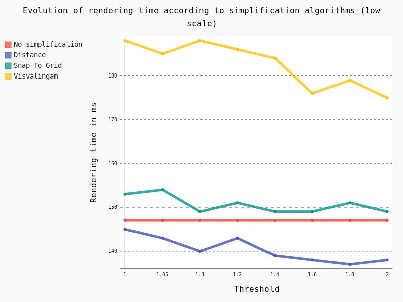
Several conclusions can be drawn:
- Visvalingam algorithm should be avoided at low scale too
- Snap To Grid seems counter-productive at low scale
- Distance algorithm seems to be a good option
Lines
For these tests we also use the same dataset as that for daily performance tests, which is a layer of lines with 125,782 features.

Feature simplification activated
In the same way as for polygons we have tested the effect of the geometric simplification on the rendering time, as well as algorithms and thresholds:

In this case we have exactly the same conclusion as for polygons: the Distance algorithm should be preferred with a threshold of 1.05.
For QGIS Server the mean rendering time is about 1180 ms with geometry simplification compared to 1108 ms for QGIS Desktop, which is totally consistent. And looking at the FlameGraph we note that once again most of the time is spent in accessing the PostgreSQL database (about 30%) and rendering features (about 40%).
Symbology
Another parameter which has an obvious impact on performance is the symbology used to draw the layers. Some features are known to be time consuming, but we’ve felt that a a thorough study was necessary to verify it.
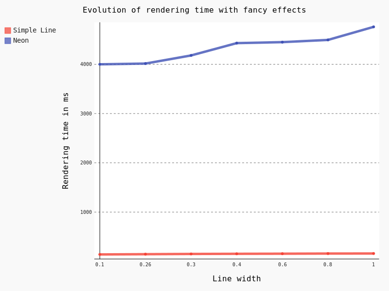
Firstly, we’ve studied the influence of the width as well as the Single Symbol type on the rendering time.
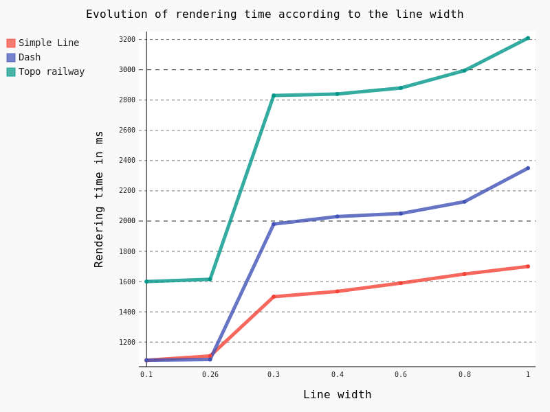 Some points are noteworthy:
– Simple Line is clearly the less time consuming
– Beyond the default 0.26 line width, rendering time begins to raise consequently with a clear jump in performance
Another interesting feature is the Draw effects option, allowing to add some fancy effects (shadow, glow, …).
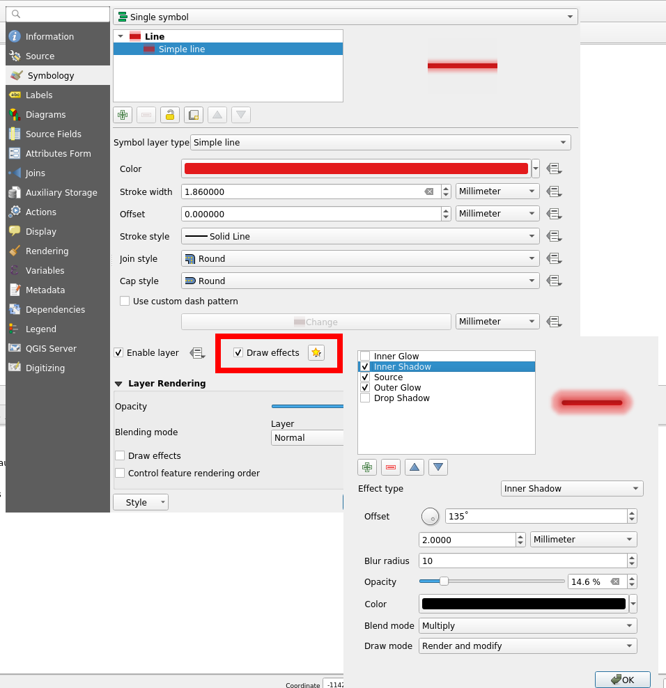
However, this feature is known to be particularly CPU consuming. Actually, rendering all the 125,782 lines took so long that we had to to change to a lower scale, with just some a few dozen lines. Results are unequivocal:
The last thing we wanted to test for symbology is the effect of the Categorized classification. Here are the results for some classifications with geometry simplification activated:
- No classification: 1108 ms
- A simple classification using the column “classification” (8 symbols): 1148 ms
- A classification based on a stupid expression “classification x 3″ (8 symbols): 1261 ms
- A classification based on string comparison “toponyme like ‘Ruisseau*'” (2 symbols): 1380 ms
- A classification with a specific width line for each category (8 symbols): 1850 ms
Considering that a simple classification does not add an excessive extra-cost, it seems that the classification process itself is not very time consuming. However, as soon as an expression is used, we can observe a slight jump in performance.
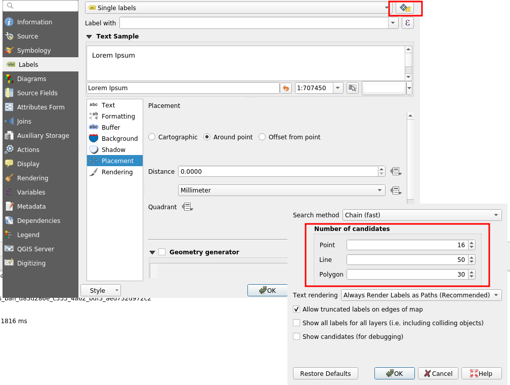
Labeling
Another important part to study regarding performance is labeling and the underlying positioning. For this test we decreased the scale and varied the Placement parameter without tuning anything.
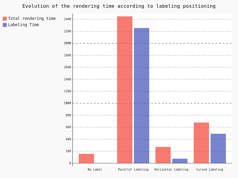
Clearly, the parallel labeling is much more time consuming than the other placements. However, as previously stated, we used the default parameters for each positioning, meaning that the number of labels really drawn on the map differs from a placement to another.
Points
The last kind of geometries we have to study is points. Similarly to polygons and lines, we used the same dataset as that of performance tests, that is a layer with 435588 points.
In the case of points geometries geometry simplification is of course not available. So we are going to focus on symbology and the impact of marker size.
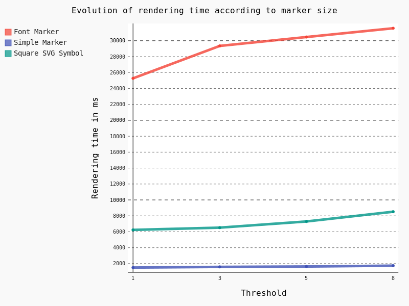
Obviously Font Marker must be used carefully because of the underlying jump in performance, as well as SVG Symbols. Moreover, contrary to Simple Marker, an increase of the size implies a drastic augmentation in time rendering.
General conclusion
Based on this factual study, several conclusions can be drawn.
Globally, FlameGraph for QGIS Desktop and QGIS Server are completely similar as well as rendering time.
It means that if we want to improve the performance of QGIS Server, we have to work on the desktop configuration and the rendering engine of the QGIS core library.
Extracting generic conclusions from our tests is very difficult, because it clearly depends on the underlying data. But let’s try to suggest some recommendations :).
Firstly, geometry simplification seems pretty efficient with lines and polygons as soon as the algorithm is chosen cautiously, and as long as your features include many vertices. It seems that the Distance algorithm with a 1.05 threshold is a good choice, with both high and low scale. However, it’s not a magic solution!
Secondly, a special care is needed with regards to symbology. Indeed, in some cases, a clear jump in performance is notable. For example, fancy effects and Font Marker / SVG Symbol have to be used with caution if you’re picky on rendering time.
Thirdly, we have to be aware of the extra cost caused by labeling, especially the Parallel placement for line geometries. On this subject, a not very well-known parameter allows to drastically reduce labeling time: the PAL candidates option. Actually, we may decrease the labeling time by reducing the number of candidates. For an explicit use case, you can take a look at the daily reports.
In any case, improving server performance in a substantial way means improving the QGIS core library directly.
Especially, we noticed thanks to FlameGraph that most of the time is spent in drawing features and managing the data from the PostgreSQL database. By the way, a legitimate question is: “How much time do we spend on waiting for the database?”. To be continued 
If you hit performance issues on your specific configuration or want to improve QGIS awesomeness, we provide a unique QGIS support offer at http://qgis.oslandia.com/ thanks to our team of specialists!
QGIS Server 3.4.6 certified for WMS 1.3
We are very happy to announce that QGIS 3.4.6 LTR is now OGC certified as a reference implementation : ![]()
The OGC certification program gives a third party validation that the a web service is compliant with the standard.
The certification process requires manual work, so we will only certify on version for each LTR. This was not enough, so we build a OGC CI test platform that is checking compliance every night for WMS and WFS, so that you can check by yourself any specific version commit.
However WMS 1.3 is only the basics, if you rely on other services like WFS, WCS, or advanced capabilities like Raster or Vector Elevation, we are looking for supporters!
As the future is almost now If you want QGIS to be on the cutting edge with the upcoming WFS3, a JSON-REST modern version of WFS, please get in touch. We’d love to push this both into QGIS server and Desktop.
QGIS Server certified as official OGC reference implementation
We are very excited to announce that QGIS Server has been successfully certified as a compliant WMS 1.3 server against the OGC certification platform, and moreover, it is even considered as a reference implementation now!
![]()
This is the first step on our roadmap of having a fast, compliant and bullet proof web map server that is straightforward to publish from a classical QGIS project.
What does it mean?
Having a certified server means that QGIS Server successfully passes the automated and semi automated tests that ensure we are 100% compliant with the standards. That means you can trust QGIS to be used by any WMS client seamlessly.
Moreover, that certification is now powered by a continuous integration system that checks every night in developement versions if we still pass the tests.
Daily compliance reports are available on the new test.qgis.org website.
What’s next?
Building the automated testing platform and getting officially certified was only the first step. We now are starting to certify the WFS services, thanks to the latest grant application program support.
We also want QGIS server development to be performance-driven. The following projects are particularly relevant:
- MS-Perf produces benchmark reports with MapServer and GeoServer.
- graffiti and PerfSuite tools have been designed to create a really light tool, easy to enrich with new datasets and performance tests, and easy to integrate in continuous integration systems. It compares QGIS-ltr, QGIS-rel and QGIS-dev nightlies for the same scenarios in details and produces html reports. It can also graph performance history for the development version to track regressions or improvements.
Many thanks to the supporters and voting members that helped bootstrap all those testing platforms and offer them to the community.
If you want to support or give a hand on the QGIS desktop client side, we think that area would deserve some love too!
QGIS 3 Server deployment showcase with Python superpowers
Recently I was invited by the colleagues from OpenGIS.ch to lend a hand in a training session about QGIS server.
This was a good opportunity to update my presentation for QGIS3, to fix a few bugs and to explore the powerful capabilities of QGIS server and Python.
As a result, I published the full recipe of a Vagrant VM on github: https://github.com/elpaso/qgis3-server-vagrant
The presentation is online here: http://www.itopen.it/bulk/qgis3-server/
What’s worth mentioning is the sample plugins (I’ll eventually package and upload them to the official plugin site):
- XYZ: add simple XYZ tile server, ready to use within QGIS XYZ connections: https://github.com/elpaso/qgis3-server-vagrant/tree/master/resources/web/plugins/xyz
- custom service, does nothing but shows how to create a Python custom service by exploiting the new service capabilities available in QGIS3: https://github.com/elpaso/qgis3-server-vagrant/tree/master/resources/web/plugins/customservice
- HTTP Basic auth (how to add your auth scheme to QGIS server): https://github.com/elpaso/qgis3-server-vagrant/tree/master/resources/web/plugins/httpbasic
- more …
The VM uses 4 different (although similar) deployment strategies:
- good old Apache + mod_fcgi and plain CGI
- Nginx + Fast CGI
- Nginx + standalone HTTP Python wrapped server
- Nginx + standalone WSGI Python wrapped server
Have fun with QGIS server: it was completely refactored in QGIS 3 and it’s now better than ever!
The post QGIS 3 Server deployment showcase with Python superpowers first appeared on Open Web Solutions, GIS & Python Development.
QGIS Server refactoring is done!
As you may know, QGIS is jumping to a new major version. (Yes!) Doing so was made necessary because of the need to switch to Python 3, Qt5, but also because we needed to break the QGIS API in several places.
A year ago there was an appeal on the QGIS developer mailing list about the strong need for love that the QGIS server code base required. Indeed, the API was locked by some old methods of QGIS server. In short, QGIS server was reparsing the .qgs project file in its own way, and created dependencies to parts of QGIS we needed to drop.
As outsourcing the server code base was not an option, so we had to refactor it. The involved parties decided to get engaged in a code sprint in the city of Lyon , France dedicated to sharing their vision, planning the work and finally making all the following happen:
Higher level refactoring
All services (WMS GetMap, WFS GetFeature, GetLegendGraphics, WCS, GetPrint etc..) have been rewritten. Some like WMS were entirely rewritten. Kudos to the devs!
New features
- Multi-thread rendering like in the desktop
- A new option to trust layer metadata and thus speed up project loading
- WFS 1.1 support https://github.com/qgis/QGIS/pull/5297
- Full Python bindings for the server API
- Server services as plugins like providers
Deep, complex and unrewarding tasks
- Remove all singleton calls
- Cut all the dependencies to the old QGIS project file parser
- Minimize dependencies to GUI library. Since fonts are necessary to render maps, totally removing them was not feasible.
Infrastructure tasks
- Build a OGC compliancy platform and integrate it to a continuous integration platform. Conformity reports are now pushed to tests.qgis.org
- Add unit tests … and again more unit tests
- Stress QGIS server against security leaks (SQL injections and other malicious attacks)
- Start profiling and bench marking performances. This work still needs some love – and funding – to be achieved
Additionally, some of these new developments have already been presented at FOSS4G-EU in July.
Congratulations to the developers who worked hard on this!
Now this deserves to be well tested, please report back any issues!
A little QGIS3 Server wsgi experiment
Here is a little first experiment for a wsgi wrapper to QGIS 3 Server, not much tested, but basically working:
#!/usr/bin/env python

# Simple QGIS 3 Server wsgi test

import signal
import sys
from cgi import escape, parse_qs
from urllib.parse import quote
# Python's bundled WSGI server
from wsgiref.simple_server import make_server

from qgis.core import QgsApplication
from qgis.server import *

# Init QGIS
qgs_app = QgsApplication([], False)
# Init server
qgs_server = QgsServer()


def reconstruct_url(environ):
    """Standard algorithm to retrieve the full URL from wsgi request
    From: https://www.python.org/dev/peps/pep-0333/#url-reconstruction
    """
    url = environ['wsgi.url_scheme']+'://'

    if environ.get('HTTP_HOST'):
        url += environ['HTTP_HOST']
    else:
        url += environ['SERVER_NAME']

        if environ['wsgi.url_scheme'] == 'https':
            if environ['SERVER_PORT'] != '443':
                url += ':' + environ['SERVER_PORT']
        else:
            if environ['SERVER_PORT'] != '80':
                url += ':' + environ['SERVER_PORT']

    url += quote(environ.get('SCRIPT_NAME', ''))
    url += quote(environ.get('PATH_INFO', ''))
    if environ.get('QUERY_STRING'):
        url += '?' + environ['QUERY_STRING']
    return url

def application (environ, start_response):

    headers = {} # Parse headers from environ here if needed

    # the environment variable CONTENT_LENGTH may be empty or missing
    # When the method is POST the variable will be sent
    # in the HTTP request body which is passed by the WSGI server
    # in the file like wsgi.input environment variable.
    try:
        request_body_size = int(environ.get('CONTENT_LENGTH', 0))
        request_body = environ['wsgi.input'].read(request_body_size)
    except (ValueError):
        request_body_size = 0
        request_body = None

    request = QgsBufferServerRequest(reconstruct_url(environ), (QgsServerRequest.PostMethod
        if environ['REQUEST_METHOD'] == 'POST' else QgsServerRequest.GetMethod), {}, request_body)
    response = QgsBufferServerResponse()
    qgs_server.handleRequest(request, response)
    headers_dict = response.headers()
    try:
        status = headers_dict['Status']
    except KeyError:
        status = '200 OK'
    start_response(status, [(k, v) for k, v in headers_dict.items()])
    return [bytes(response.body())]

# Instantiate the server
httpd = make_server (
    'localhost', # The host name
    8051, # A port number where to wait for the request
    application # The application object name, in this case a function
)

print("Listening to http://localhost:8051 press CTRL+C to quit")

def signal_handler(signal, frame):
    """Exit QGIS cleanly"""
    global qgs_app
    print("\nExiting QGIS...")
    qgs_app.exitQgis()
    sys.exit(0)

signal.signal(signal.SIGINT, signal_handler)

httpd.serve_forever()
The post A little QGIS3 Server wsgi experiment first appeared on Open Web Solutions, GIS & Python Development.
Essen 2017 QGIS Hackfest
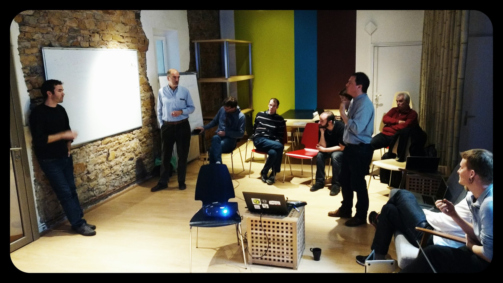
Another great QGIS hackfest is gone, and it’s time for a quick report. The location was the Linux Hotel, one of the best places where open source developers could meet, friendly, geek-oriented and when the weather is good, like this time, villa Vogelsang is a wonderful place to have a beer in the garden while talking about software development or life in general. This is a short list of what kept me busy during the hackfest:
- fixed some bugs and feature requests on the official QGIS plugin repo that I’m maintaining since the very beginning
- make the QGIS official plugin repository website mobile-friendly
- QGIS Server Python Plugin API refactoring, I’ve completed the work on the new API, thanks to the ongoing server refactoring it’s now much cleaner than it was in the first version
- attribute table bugs: I started to address some nasty bugs in the attribute table, some of those were fixed during the week right after the hackfest
- unified add layer button, we had a productive meeting where we decided the path forward to implement this feature, thanks to Boundless that is funding the development, this feature is what’s I’m currently working on these days
The post Essen 2017 QGIS Hackfest first appeared on Open Web Solutions, GIS & Python Development.
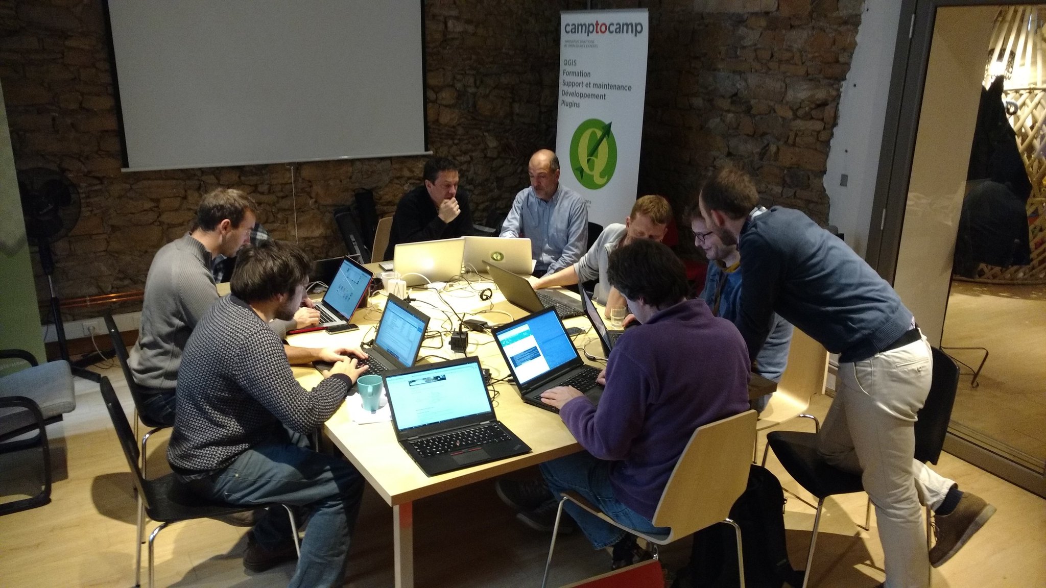
QGIS Developer Sprint in Lyon
QGIS Developer Sprint in Lyon QGIS Server 3.0 is going to be better than ever! Last week I attended to the mini code-sprint organized by the french QGIS developers in Lyon. The code sprint was focused on QGIS Server refactoring to reach the following goals:
- increase maintainability through modularity and clean code responsibilities
- increase performances
- better multi-project handling and caching
- scalability
- multi threaded rendering
The post QGIS Developer Sprint in Lyon first appeared on Open Web Solutions, GIS & Python Development.
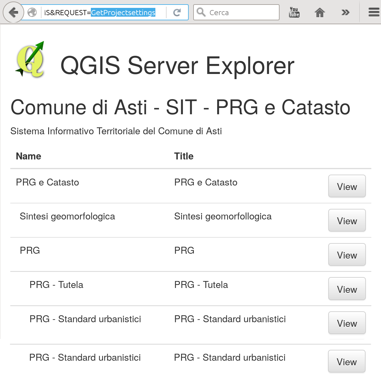
QGIS Server Simple Browser Plugin
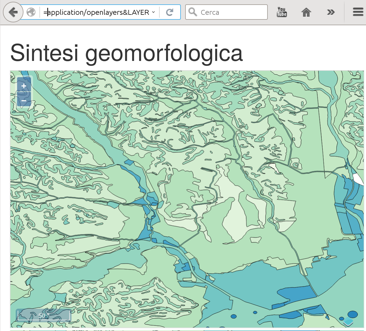
Today I’m releasing the first version of QGIS Server Simple Browser Plugin, a simple Server plugin that generates a browsable table of contents of the project’s layers and a link to an OpenLayers map.
How it works
The plugin adds anXSL stylesheet to GetProjectsettings XML response, the generated HTML looks like this:
The openlayers format
The map preview is generated by adding a newapplication/openlayers FORMAT option to GetMap requests, the generated map automatically fits to the layer’s extent and has basic GetFeatureInfo
capabilities.
Limitations
The current version only supportsEPSG:4326 that must be available (enabled) on the server.
Source code and download
The plugin is available on the official repository: ServerSimpleBrowser The code is on GitHub.QGIS Server Debug Tip
Sometimes is hard to debug segfaults appearing in QGIS Server when running in CGI mode.
The classic approach is attaching a gdb to the running process.
The problem is that there is not enough time to do it!
A simple plugin filter, can provide you the time you need to attach the debugger:
from qgis.server import *
from qgis.core import *
import os

class DelayFilter(QgsServerFilter):

    def __init__(self, serverIface):
        super(DelayFilter, self).__init__(serverIface)

    def responseComplete(self):
        request = self.serverInterface().requestHandler()
        params = request.parameterMap()
        if params.get('DELAY', ''):
            QgsMessageLog.logMessage("PID: %s" % os.getpid())
            import time
            time.sleep(30)
Calling the server with DELAY=1 will wait for 30 seconds and print the current PID in the server logs.
This will give you enough time to fire gdb and attach it to the process.
QGIS Server binding news
With QGIS 2.12 the new Python bindings for QGIS server are now available and the server can be invoked directly from a python scripts with just a few lines of code:
from qgis.server import QgsServer
my_query_string = "map=/projects/my_project.qgs&SERVICE=WMS&request=GetCapabilities"
headers, body =  QgsServer().handleRequest(my_query_string)
Embedding QGIS in a Python web application
Embedding QGIS Server in a web application is now not only possible but really very easy, for example, a Django view:
# QGIS server view

from django.http import HttpResponse
from django.views.generic import View
from qgis.server import *


class OGC(View):
    """Pass a GET request to QGIS Server and return the response"""

    def __init__(self):
        self.server = QgsServer()

    def get(self, request, *args, **kwargs):
        """Pass a GET request to QGIS Server and return the response"""
        headers, body = self.server.handleRequest(request.GET.urlencode())
        response = HttpResponse(body)
        # Parse headers
        for header in headers.split('\n'):
            if header:
                k, v = header.split(': ', 1)
                response[k] = v
        return response
Using server plugins
Of course Python server plugins can be plugged in easily, see the example below:
# QGIS server view

from django.http import HttpResponse
from django.views.generic import View
from qgis.server import *
from qgis.core import *


class OGC(View):
    """Pass a GET request to QGIS Server and return the response"""

    def __init__(self):
        self.server = QgsServer()
        # Call init to create serverInterface
        self.server.init()
        serverIface = self.server.serverInterface()

        class Filter1(QgsServerFilter):
            def responseComplete(self):
                QgsMessageLog.logMessage("Filter1.responseComplete", "Server", QgsMessageLog.INFO )
                request = self.serverInterface().requestHandler()
                if request.parameter('REQUEST') == 'HELLO':
                    request.clearHeaders()
                    request.setHeader('Content-type', 'text/plain')
                    request.clearBody()
                    request.appendBody('Hello from SimpleServer!')

            def requestReady(self):
                QgsMessageLog.logMessage("Filter1.requestReady")

        self.filter = Filter1(serverIface)
        serverIface.registerFilter(self.filter)


    def get(self, request, *args, **kwargs):
        """Pass a GET request to QGIS Server and return the response"""
        headers, body = self.server.handleRequest(request.GET.urlencode())
        response = HttpResponse(body)
        # Parse headers
        for header in headers.split('\n'):
            if header:
                k, v = header.split(': ', 1)
                response[k] = v
        return response
Enjoy QGIS Server with Python!
QGIS Server powers the new City of Asti WebGIS
A few days ago the new WebGIS of the City of Asti, a 76000 inhabitants city in Piedmont, was launched. The new WebGIS uses QGIS Server and QGIS Web Client to serve maps and provide street and cadastrial search and location services.
The new WebGIS was developed by ItOpen and is online at: http://sit.comune.asti.it/site/?map=PRGAsti
QGIS developer meeting in Nødebo
During the hackfest I’ve been working on the refactoring of the server component, aimed to wrap the server into a class and create python bindings for the new classes. This work is now in the PR queue and brings a first working python test for the server itself.
The server can now be invoked directly from python, like in the example below:
#!/usr/bin/env python
"""
Super simple QgsServer.
"""

from qgis.server import *
from BaseHTTPServer import *

class handler (BaseHTTPRequestHandler):

    server = QgsServer()

    def _doHeaders(self, response):
        l = response.pop(0)
        while l:
            h = l.split(':')
            self.send_header(h[0], ':'.join(h[1:]))
            self.log_message( "send_header %s - %s" % (h[0], ':'.join(h[1:])))
            l = response.pop(0)
        self.end_headers()

    def do_HEAD(self):
        self.send_response(200)
        response = str(handler.server.handleRequestGetHeaders(self.path[2:])).split('\n')
        self._doHeaders(response)

    def do_GET(self):
        response = str(handler.server.handleRequest(self.path[2:])).split('\n')
        i = 0
        self.send_response(200)
        self._doHeaders(response)
        self.wfile.write(('\n'.join(response[i:])).strip())

    def do_OPTIONS(s):
        handler.do_GET(s)

httpd = HTTPServer( ('', 8000), handler)

while True:
    httpd.handle_request()
The python bindings capture the server output instead of printing it on FCGI stdout and allow to pass the request parameters QUERY_STRING directly to the request handler as a string, this makes writing python tests very easy.
QGIS server python plugins tutorial
This is the second article about python plugins for QGIS server, see also the introductory article posted a few days ago.
In this post I will introduce the helloServer example plugin that shows some common implementation patterns exploiting the new QGIS Server Python Bindings API.
Server plugins and desktop interfaces
Server plugins can optionally have a desktop interface exactly like all standard QGIS plugins.
A typical use case for a server plugin that also has a desktop interface is to allow the users to configure the server-side of the plugin from QGIS desktop, this is the same principle of configuring WMS/WFS services of QGIS server from the project properties.
The only important difference it that while the WMS/WFS services configuration is stored in the project file itself, the plugins can store and access project data but not to the user’s settings (because the server process normally runs with a different user). For this reason, if you want to share configuration settings between the server and the desktop, provided that you normally run the server with a different user, paths and permissions have to be carefully configured to grant both users access to the shared data.
Server configuration
This is an example configuration for Apache, it covers both FCGI and CGI:
  ServerAdmin webmaster@localhost
  # Add an entry to your /etc/hosts file for xxx localhost e.g.
  # 127.0.0.1 xxx
  ServerName xxx
    # Longer timeout for WPS... default = 40
    FcgidIOTimeout 120
    FcgidInitialEnv LC_ALL "en_US.UTF-8"
    FcgidInitialEnv PYTHONIOENCODING UTF-8
    FcgidInitialEnv LANG "en_US.UTF-8"
    FcgidInitialEnv QGIS_DEBUG 1
    FcgidInitialEnv QGIS_CUSTOM_CONFIG_PATH "/home/xxx/.qgis2/"
    FcgidInitialEnv QGIS_SERVER_LOG_FILE /tmp/qgis.log
    FcgidInitialEnv QGIS_SERVER_LOG_LEVEL 0
    FcgidInitialEnv QGIS_OPTIONS_PATH "/home/xxx/public_html/cgi-bin/"
    FcgidInitialEnv QGIS_PLUGINPATH "/home/xxx/.qgis2/python/plugins"
    FcgidInitialEnv LD_LIBRARY_PATH "/home/xxx/apps/lib"

    # For simple CGI: ignored by fcgid
    SetEnv QGIS_DEBUG 1
    SetEnv QGIS_CUSTOM_CONFIG_PATH "/home/xxx/.qgis2/"
    SetEnv QGIS_SERVER_LOG_FILE /tmp/qgis.log
    SetEnv QGIS_SERVER_LOG_LEVEL 0
    SetEnv QGIS_OPTIONS_PATH "/home/xxx/public_html/cgi-bin/"
    SetEnv QGIS_PLUGINPATH "/home/xxx/.qgis2/python/plugins"
    SetEnv LD_LIBRARY_PATH "/home/xxx/apps/lib"

    RewriteEngine On

        RewriteCond %{HTTP:Authorization} .
        RewriteRule .* - [E=HTTP_AUTHORIZATION:%{HTTP:Authorization}]


  ScriptAlias /cgi-bin/ /home/xxx/apps/bin/
  <Directory "/home/xxx/apps/bin/">
    AllowOverride All
    Options +ExecCGI -MultiViews +FollowSymLinks
    Require all granted

  ErrorLog ${APACHE_LOG_DIR}/xxx-error.log
  CustomLog ${APACHE_LOG_DIR}/xxx-access.log combined
In this particular example, I’m using a QGIS server built from sources and installed in /home/xxx/apps/bin the libraries are in /home/xxx/apps/lib and LD_LIBRARY_PATH poins to this location.
QGIS_CUSTOM_CONFIG_PATH tells the server where to search for QGIS configuration (for example qgis.db).
QGIS_PLUGINPATH is searched for plugins as start, your server plugins must sit in this directory, while developing you can choose to use the same directory of your QGIS desktop installation.
QGIS_DEBUG set to 1 to enable debug and logging.
Anatomy of a server plugin
For a plugin to be seen as a server plugin, it must provide correct metadata informations and a factory method:
Plugin metadata
A server enabled plugins must advertise itself as a server plugin by adding the line
server=True
in its metadata.txt file.
The serverClassFactory method
A server enabled plugins is basically just a standard QGIS Python plugins that provides a serverClassFactory(serverIface) function in its __init__.py. This function is invoked once when the server starts to generate the plugin instance (it’s called on each request if running in CGI mode: not recommended) and returns a plugin instance:
def serverClassFactory(serverIface):
    from HelloServer import HelloServerServer
    return HelloServerServer(serverIface)
You’ll notice that this is the same pattern we have in “traditional” QGIS plugins.
Server Filters
A server plugin typically consists in one or more callbacks packed into objects called QgsServerFilter.
Each QgsServerFilter implements one or all of the following callbacks:
- requestReady ()
- responseComplete ()
- sendResponse ()
The following example implements a minimal filter which prints HelloServer! in case the SERVICE parameter equals to “HELLO”.
from qgis.server import *
from qgis.core import *

class HelloFilter(QgsServerFilter):

    def __init__(self, serverIface):
        super(HelloFilter, self).__init__(serverIface)

    def responseComplete(self):
        request = self.serverInterface().requestHandler()
        params = request.parameterMap()
        if params.get('SERVICE', '').upper() == 'HELLO':
            request.clearHeaders()
            request.setHeader('Content-type', 'text/plain')
            request.clearBody()
            request.appendBody('HelloServer!')
The filters must be registered into the serverIface as in the following example:
class HelloServerServer:
    def __init__(self, serverIface):
        # Save reference to the QGIS server interface
        self.serverIface = serverIface
        serverIface.registerFilter( HelloFilter, 100 )
The second parameter of registerFilter allows to set a priority which defines the order for the callbacks with the same name (the lower priority is invoked first).
Full control over the flow
By using the three callbacks, plugins can manipulate the input and/or the output of the server in many different ways. In every moment, the plugin instance has access to the QgsRequestHandler through the QgsServerInterface, the QgsRequestHandler has plenty of methods that can be used to alter the input parameters before entering the core processing of the server (by using requestReady) or after the request has been processed by the core services (by using sendResponse).
The following examples cover some common use cases:
Modifying the input
The example plugin contains a test example that changes input parameters coming from the query string, in this example a new parameter is injected into the (already parsed) parameterMap, this parameter is then visible by core services (WMS etc.), at the end of core services processing we check that the parameter is still there.
from qgis.server import *
from qgis.core import *

class ParamsFilter(QgsServerFilter):

    def __init__(self, serverIface):
        super(ParamsFilter, self).__init__(serverIface)

    def requestReady(self):
        request = self.serverInterface().requestHandler()
        params = request.parameterMap( )
        request.setParameter('TEST_NEW_PARAM', 'ParamsFilter')

    def responseComplete(self):
        request = self.serverInterface().requestHandler()
        params = request.parameterMap( )
        if params.get('TEST_NEW_PARAM') == 'ParamsFilter':
            QgsMessageLog.logMessage("SUCCESS - ParamsFilter.responseComplete", 'plugin', QgsMessageLog.INFO)
        else:
            QgsMessageLog.logMessage("FAIL    - ParamsFilter.responseComplete", 'plugin', QgsMessageLog.CRITICAL)
This is an extract of what you see in the log file:
src/core/qgsmessagelog.cpp: 45: (logMessage) [0ms] 2014-12-12T12:39:29 plugin[0] HelloServerServer - loading filter ParamsFilter
src/core/qgsmessagelog.cpp: 45: (logMessage) [1ms] 2014-12-12T12:39:29 Server[0] Server plugin HelloServer loaded!
src/core/qgsmessagelog.cpp: 45: (logMessage) [0ms] 2014-12-12T12:39:29 Server[0] Server python plugins loaded
src/mapserver/qgsgetrequesthandler.cpp: 35: (parseInput) [0ms] query string is: SERVICE=HELLO&request=GetOutput
src/mapserver/qgshttprequesthandler.cpp: 547: (requestStringToParameterMap) [1ms] inserting pair SERVICE // HELLO into the parameter map
src/mapserver/qgshttprequesthandler.cpp: 547: (requestStringToParameterMap) [0ms] inserting pair REQUEST // GetOutput into the parameter map
src/mapserver/qgsserverfilter.cpp: 42: (requestReady) [0ms] QgsServerFilter plugin default requestReady called
src/core/qgsmessagelog.cpp: 45: (logMessage) [0ms] 2014-12-12T12:39:29 plugin[0] HelloFilter.requestReady
src/mapserver/qgis_map_serv.cpp: 235: (configPath) [0ms] Using default configuration file path: /home/xxx/apps/bin/admin.sld
src/mapserver/qgshttprequesthandler.cpp: 49: (setHttpResponse) [0ms] Checking byte array is ok to set...
src/mapserver/qgshttprequesthandler.cpp: 59: (setHttpResponse) [0ms] Byte array looks good, setting response...
src/core/qgsmessagelog.cpp: 45: (logMessage) [0ms] 2014-12-12T12:39:29 plugin[0] HelloFilter.responseComplete
src/core/qgsmessagelog.cpp: 45: (logMessage) [0ms] 2014-12-12T12:39:29 plugin[0] SUCCESS - ParamsFilter.responseComplete
src/core/qgsmessagelog.cpp: 45: (logMessage) [0ms] 2014-12-12T12:39:29 plugin[0] RemoteConsoleFilter.responseComplete
src/mapserver/qgshttprequesthandler.cpp: 158: (sendResponse) [0ms] Sending HTTP response
src/core/qgsmessagelog.cpp: 45: (logMessage) [0ms] 2014-12-12T12:39:29 plugin[0] HelloFilter.sendResponse
On line 13 the “SUCCESS” string indicates that the plugin passed the test.
The same technique can be exploited to use a custom service instead of a core one: you could for example skip a WFS SERVICE request or any other core request just by changing the SERVICE parameter to something different and the core service will be skipped, then you can inject your custom results into the output and send them to the client (this is explained here below).
Changing or replacing the output
The watermark filter example shows how to replace the WMS output with a new image obtained by adding a watermark image on the top of the WMS image generated by the WMS core service:
import os

from qgis.server import *
from qgis.core import *
from PyQt4.QtCore import *
from PyQt4.QtGui import *


class WatermarkFilter(QgsServerFilter):

    def __init__(self, serverIface):
        super(WatermarkFilter, self).__init__(serverIface)

    def responseComplete(self):
        request = self.serverInterface().requestHandler()
        params = request.parameterMap( )
        # Do some checks
        if (request.parameter('SERVICE').upper() == 'WMS' \
                and request.parameter('REQUEST').upper() == 'GETMAP' \
                and not request.exceptionRaised() ):
            QgsMessageLog.logMessage("WatermarkFilter.responseComplete: image ready %s" % request.infoFormat(), 'plugin', QgsMessageLog.INFO)
            # Get the image
            img = QImage()
            img.loadFromData(request.body())
            # Adds the watermark
            watermark = QImage(os.path.join(os.path.dirname(__file__), 'media/watermark.png'))
            p = QPainter(img)
            p.drawImage(QRect( 20, 20, 40, 40), watermark)
            p.end()
            ba = QByteArray()
            buffer = QBuffer(ba)
            buffer.open(QIODevice.WriteOnly)
            img.save(buffer, "PNG")
            # Set the body
            request.clearBody()
            request.appendBody(ba)
In this example the SERVICE parameter value is checked and if the incoming request is a WMS GETMAP and no exceptions have been set by a previously executed plugin or by the core service (WMS in this case), the WMS generated image is retrieved from the output buffer and the watermark image is added. The final step is to clear the output buffer and replace it with the newly generated image. Please note that in a real-world situation we should also check for the requested image type instead of returning PNG in any case.
The power of python
The examples above are just meant to explain how to interact with QGIS server python bindings but server plugins have full access to all QGIS python bindings and to thousands of python libraries, what you can do with python server plugins is just limited by your imagination!
See all QGIS Server related posts
QGIS server python plugins
Today it’s a great day for QGIS Server: Python plugins, the project that took me busy during the past two months, has been merged to master and will be available starting with the next QGIS release.
The project has been discussed and approved in Essen during the last QGIS HF (see my presentation about server plugins), thanks to the input and suggestions coming from Marco Hugentobler and Martin Dobias it is now implemented in the more complete and flexible way.
In this article I will introduce the core concepts and the main features of python plugins for QGIS server.
QGIS server plugins architecture
QGIS server provides some core services: WFS, WMS, WCS. What we wanted to achieve was a system to easily add new services and modify existing services through python plugins.
Mi first experiments were limited to a 404 handler that intercepts unhandled requests and hooks into python plugins capturing every stdout output, this was indeed not enough flexible for a full fledged plugins implementation.
The main loop
QGIS server is not different from most web services implementations: it listens for incoming requests, parses the URL query string parameters and returns its output accordingly to the incoming request.
The standard loop before introducing python plugins looked like the following:
- Get the request
- create GET/POST/SOAP request handler
- if SERVICE is WMS/WFS/WCS
- create WMS/WFS/WCS server passing in request handler
- call server’s
executeRequest()- call request handler output method
- call server’s
- create WMS/WFS/WCS server passing in request handler
- else
Exception
Plugins come into play
Server python plugins are loaded once when the FCGI application starts and they should register one or more QgsServerFilter (from this point, you might find useful a quick look to the server plugins API docs). Each filter should implement at least one of three callbacks (aka: hooks):
All filters have access to the request/response object (QgsRequestHandler) and can manipulate all its properties (input/output) and can raise exceptions (while in a quite particular way as we’ll see below).
Here is a pseudo code showing how and when the filter’s callbacks are called:
-
- Get the request
-
- create GET/POST/SOAP request handler
- pass request to
serverIface - call plugins
requestReadyfilters - if there is not a response
- if SERVICE is WMS/WFS/WCS
- create WMS/WFS/WCS server
- call server’s
executeRequestand possibily callsendResponseplugin filters when streaming output or store the byte stream output and content type in the request handler
- call server’s
- create WMS/WFS/WCS server
- call plugins
responseCompletefilters
- if SERVICE is WMS/WFS/WCS
-
call plugins
sendResponsefilters - request handler output the response
requestReady
This is called when the request is ready: incoming URL and data have been parsed and before entering the core services (WMS, WFS etc.) switch, this is the point where you can manipulate the input and perform actions like:
- authentication/authorization
- redirects
- add/remove certain parameters (typenames for example)
- raise exceptions
You could even substitute a core service completely by changing SERVICE parameter and hence bypassing the core service completely (not that this make much sense though).
Implementation details of server plugins will be discussed in depth in a future article, by now please refer to QGIS HelloServer plugin for a complete implementation of the examples and methods cited in this article.
sendResponse
This is called whenever output is sent to FCGI stdout (and from there, to the client), this is normally done after core services have finished their process and after responseComplete hook was called, but in a few cases XML can become so huge that a streaming XML implementation was needed (WFS GetFeature is one of them), in this case, sendResponse is called multiple times before the response is complete (and before responseComplete is called). The obvious consequence is that sendResponse is normally called once but might be exceptionally called multiple times and in that case (and only in that case) it is also called before responseComplete.
SendResponse is the best place for direct manipulation of core service’s output and while responseComplete is typically also an option, sendResponse is the only viable option in case of streaming services.
responseComplete
This is called once when core services (if hit) finish their process and the request is ready to be sent to the client. As discussed above, this is normally called before sendResponse except for streaming services (or other plugin filters) that might have called sendResponse earlier.
responseComplete is the ideal place to provide new services implementation (WPS or custom services) and to perform direct manipulation of the output coming from core services (for example to add a watermark upon a WMS image).
Raising exception from a plugin
Some work has still to be done on this topic: the current implementation can distinguish between handled and unhandled exceptions by setting a QgsRequestHandler property to an instance of QgsMapServiceException, this way the main C++ code can catch handled python exceptions and ignore unhandled exceptions (or better: log them).
This approach basically works but it does not satisfy my pythonic way of handle exceptions: I would rather prefer to raise exceptions from python code to see them bubbling up into C++ loop for being handled there.
Conclusions
The new plugin system is very flexible and allows for basic input/output (i.e. request/response) manipulation and for new services implementation while it remains unobtrusive and has negligible impact on performances, in the next article I will discuss server plugin implementation in depth.
See also the second part of this article.
See all QGIS Server related posts
QGIS Server Python Plugins Ubuntu Setup
Prerequisites
I assume that you are working on a fresh install with Apache and FCGI module installed with:
$ sudo apt-get install apache2 libapache2-mod-fcgid
$ # Enable FCGI daemon apache module
$ sudo a2enmod fcgid
Package installation
First step is to add debian gis repository, add the following repository:
$ cat /etc/apt/sources.list.d/debian-gis.list
deb http://qgis.org/debian trusty main
deb-src http://qgis.org/debian trusty main

$ # Add keys
$ sudo gpg --recv-key DD45F6C3
$ sudo gpg --export --armor DD45F6C3 | sudo apt-key add -

$ # Update package list
$ sudo apt-get update && sudo apt-get upgrade
Now install qgis server:
$ sudo apt-get install qgis-server python-qgis
Install the HelloWorld example plugin
This is an example plugin and should not be used in production!
Create a directory to hold server plugins, you can choose whatever path you want, it will be specified in the virtual host configuration and passed on to the server through an environment variable:
$ sudo mkdir -p /opt/qgis-server/plugins
$ cd /opt/qgis-server/plugins
$ sudo wget https://github.com/elpaso/qgis-helloserver/archive/master.zip
$ # In case unzip was not installed before:
$ sudo apt-get install unzip
$ sudo unzip master.zip
$ sudo mv qgis-helloserver-master HelloServer
Apache virtual host configuration
We are installing the server in a separate virtual host listening on port 81.
Rewrite module can be optionally enabled to pass HTTP BASIC auth headers (only needed by the HelloServer example plugin).
$ sudo a2enmod rewrite
Let Apache listen to port 81:
$ cat /etc/apache2/conf-available/qgis-server-port.conf
Listen 81
$ sudo a2enconf qgis-server-port
The virtual host configuration, stored in /etc/apache2/sites-available/001-qgis-server.conf:
<VirtualHost *:81>
    ServerAdmin webmaster@localhost
    DocumentRoot /var/www/html

    ErrorLog ${APACHE_LOG_DIR}/qgis-server-error.log
    CustomLog ${APACHE_LOG_DIR}/qgis-server-access.log combined

    # Longer timeout for WPS... default = 40
    FcgidIOTimeout 120
    FcgidInitialEnv LC_ALL "en_US.UTF-8"
    FcgidInitialEnv PYTHONIOENCODING UTF-8
    FcgidInitialEnv LANG "en_US.UTF-8"
    FcgidInitialEnv QGIS_DEBUG 1
    FcgidInitialEnv QGIS_SERVER_LOG_FILE /tmp/qgis-000.log
    FcgidInitialEnv QGIS_SERVER_LOG_LEVEL 0
    FcgidInitialEnv QGIS_PLUGINPATH "/opt/qgis-server/plugins"

    # ABP: needed for QGIS HelloServer plugin HTTP BASIC auth
    <IfModule mod_fcgid.c>
        RewriteEngine on
        RewriteCond %{HTTP:Authorization} .
        RewriteRule .* - [E=HTTP_AUTHORIZATION:%{HTTP:Authorization}]
    </IfModule>

    ScriptAlias /cgi-bin/ /usr/lib/cgi-bin/
    <Directory "/usr/lib/cgi-bin">
        AllowOverride All
        Options +ExecCGI -MultiViews +FollowSymLinks
        Require all granted
        #Allow from all
  </Directory>
</VirtualHost>
Enable the virtual host and restart Apache:
$ sudo a2ensite 001-qgis-server
$ sudo service apache2 restart
Test:
$ wget -q -O - "http://localhost:81/cgi-bin/qgis_mapserv.fcgi?SERVICE=HELLO"
HelloServer!
See all QGIS Server related posts
