Vector tiles in QGIS 3.14
The new QGIS 3.14 version adds support for the native loading of vector tiles. The easiest way to load them is via the recently released plugin.
Last update:
Tue Jan 21 23:30:33 2025
 •
•
 •
•

 •
•
 •
•

The new QGIS 3.14 version adds support for the native loading of vector tiles. The easiest way to load them is via the recently released plugin.
Very simple way of how to display map service in QGI3 without a map server.
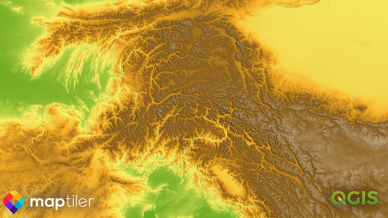
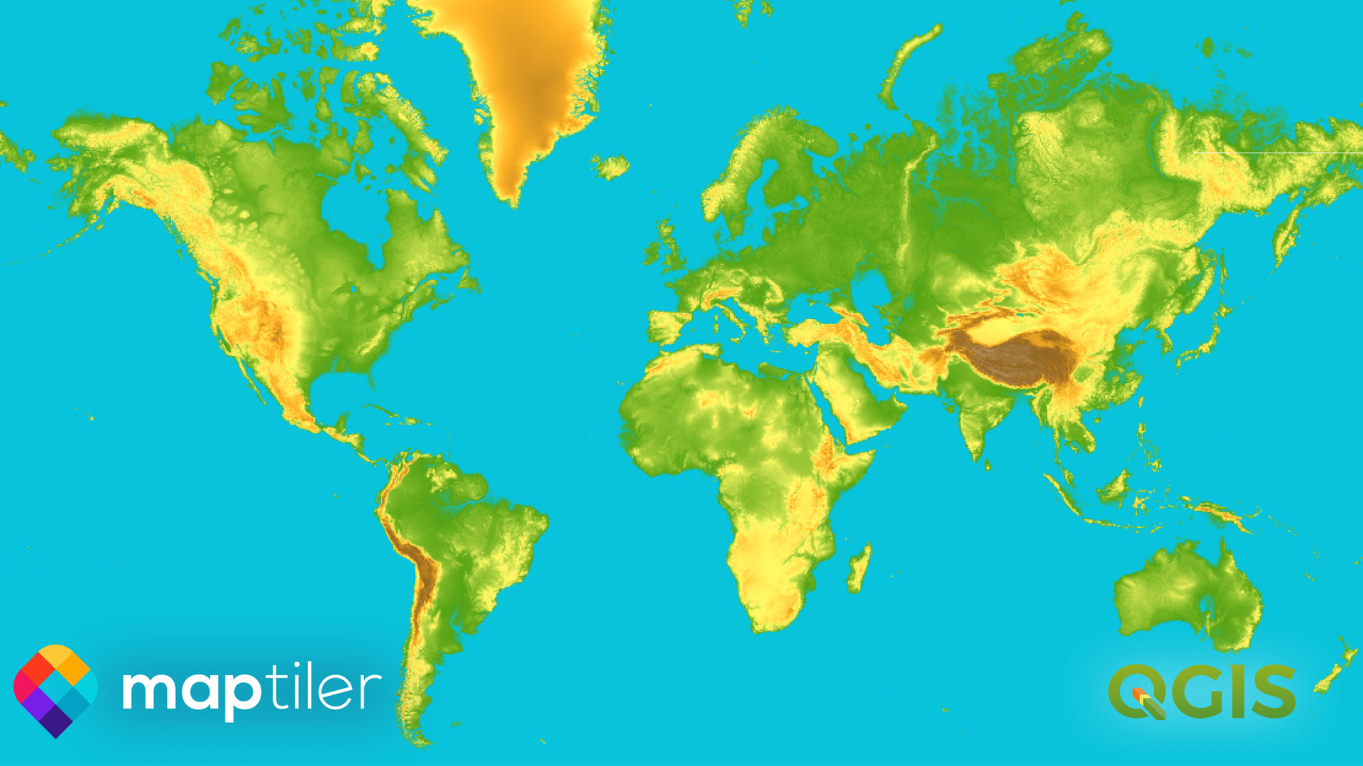
New version of MapTiler QGIS Plugin 3.0 with detailed global terrain, contour lines, hillshading, and maps using these terrain data for outdoor activities.
Open-source plugin for QGIS that loads fast vector maps. Change colors and fonts of the map to get unique look.
Details of MapTiler QGIS Plugin 3.0 with a global terrain basemap and customizable OpenStreetMap vector tiles.
The new version of the MapTiler plugin pushes our maps from MapTiler Cloud almost to perfection
The new version of the MapTiler plugin pushes our maps from MapTiler Cloud almost to perfection
Details of MapTiler QGIS Plugin 3.0 with a global terrain basemap and customizable OpenStreetMap vector tiles.
The new QGIS 3.14 version adds support for the native loading of vector tiles. The easiest way to load them is via the recently released plugin.
Very simple way of how to display map service in QGI3 without a map server.
Open-source plugin for QGIS that loads fast vector maps. Change colors and fonts of the map to get unique look.
New version of MapTiler QGIS Plugin 3.0 with detailed global terrain, contour lines, hillshading, and maps using these terrain data for outdoor activities.

The new QGIS 3.14 version adds support for the native loading of vector tiles. The easiest way to load them is via the recently released plugin.
One of the most important new features in QGIS 3.14 is the built-in support for vector tiles. The MapTiler plugin allows anybody to easily load map data of the entire planet, with details down to the street level.

The plugin automatically loads maps from MapTiler Cloud in vector or raster tiles, but can also open maps from any other URL.
For the very first time, high-quality maps of the entire world can be printed in QGIS so easily. You don’t need to care about DPI settings, because vector tiles behave as any other vector-based technology and scale infinitely with the same resolution.
 If you don’t have a large format printer at hand, export your map into PDF and zoom in deeply to inspect the level of sharpness.
A ready-to-use list of beautiful map styles is available to QGIS users. Those who prefer customized maps can make their own map design in a few clicks using the Customize tool. Users can set their own colors, fonts, or choose the language of map labels.
For power users, there is the Edit tool, with advanced functionality to allow the addition of one’s own data and the manipulation of layers.

All map styles from the MapTiler Cloud, including user-customized ones, are translated to QGIS styling. This allows you to use the styling editor in QGIS and give your maps a final touch-up.

The MapTiler plugin for QGIS allows users to load maps of the entire world (from the OpenStreetMap project), maps from official government data in the Netherlands (Kadaster maps via Cartiqo), the United Kingdom (Ordnance Survey Open Zoomstack) and Japan (GSI data), high-resolution aerial imagery, hillshading, contour line, and much more.
Geospatial data of any size can be uploaded to MapTiler Cloud and served to QGIS via MapTiler plugin.

Maps appear quickly, thanks to the tiles technology for both raster and vector data. The high speed of delivery is also reached because maps are cached on more than 150 CDN servers on five continents.
A huge advantage of vector tiles compared to raster tiles is flexibility. Reprojecting to any coordinate system inside QGIS doesn’t impact the visual appeal of the map tiles. All labels rotate accordingly, warped objects stay sharp, and much more!
You can reproject maps into any coordinate system: the default Mercator, French Lambert, Dutch RD-new, or global WGS84 to name a few.

All maps can be exported as images in GeoTIFF, PNG, or compressed JPEG, for use on the web or in raster graphics editors like Adobe Photoshop or GIMP.
For vector graphics editors like Adobe Illustrator or Inkscape, exports in SVG and PDF formats are available.
Exporting to CAD software like AutoCAD and others is possible via DWG and DXF formats.

Before making exports, print, or republishing, please contact us.
Learn more about the plugin or get it by searching maptiler in the plugin service in QGIS.
Installing the plugin is straightforward:
Now, just add the key and start loading maps. Enjoy :-)

The development is happening on GitHub. Feel free to report any issue or send a pull request, community feedback is welcomed!
We want to acknowledge people who made all this possible, namely Martin Dobias from Lutra Consulting, and Kanahiro Iguchi from MIERUNE. Thank you!

Adding beautiful maps that fit your needs is now straightforward with MapTiler plugin for QGIS. You can select one of the predefined map styles, load custom maps and use geodata hosted on a global infrastructure.
MapTiler Cloud offers a set of beautiful maps to give your data context. There are street and satellite maps of the entire world based on the OpenStreetMap project, maps in custom coordinate systems and local maps from government open data. All maps can be easily loaded to QGIS using the new plugin.

Installing the MapTiler plugin is straightforward:
Now just add your key, which you will find in the MapTiler Cloud administration on the web and you can start loading maps. Add them as a new layer and maps appear immediately.
Making your own map design can be done in a few mouse clicks. Select a map you like → right-click on the map → select Customize in Cloud → now change colors and fonts in the Customize tool the way you like → Save → Publish.

To add customized map back to QGIS, right-click on the plugin → select Add new map → pick From URL tab → fill in a Name you like and paste the 256x256 JSON URL from MapTiler Cloud and click on the OK button. That’s it, your own map is loaded to QGIS.

MapTiler Cloud also allows hosting geodata of any size, including very large analytical datasets. They can be easily added to QGIS in the same way as custom maps.
All maps and geodata are hosted on a reliable global infrastructure using more than 150 servers on 5 continents.

Agricultural data on top of the satellite map
The MapTiler plugin for QGIS is released under an open-source license on GitHub. Feel free to report issues or send pull requests!
We would like to thanks our partner, MIERUNE, which made a significant part of the work on the plugin and is a long-term supporter of the QGIS community.
For the upcoming QGIS 3.14, there is an ongoing work by Lutra Consulting on native support for vector tiles. MapTiler plugin is already able to load them - you can test it using the QGIS nightly releases.