
[Blog] 2024 - Year in review
Explore Mergin Maps' 2024 highlights: app redesigns, new features like Editor permissions, and a preview of what's coming in 2025!
Last update:
Tue Jan 21 23:30:33 2025
 •
•
 •
•

 •
•
 •
•

Explore Mergin Maps' 2024 highlights: app redesigns, new features like Editor permissions, and a preview of what's coming in 2025!
Discover how the MOSPREMA project, launched in 2022 in Czechia, uses open-source tools like Mergin Maps and PostgreSQL to monitor and manage mosquito populations. Learn how real-time data, sensors, and mapping technology improve efficiency for local municipalities.
Discover how Camptocamp, in collaboration with Zurich, used Mergin Maps and QGIS to map bird nesting sites, empowering volunteers to collect accurate survey data.
We’ve added measurement tools to Mergin Maps, allowing you to measure both distance and area directly within the app. The new "Measure" action is accessible from the "more" menu, where you can easily add points to calculate lengths and areas in your projects. The process is similar to creating a line feature, with a live display of the measured distance and options to undo, add points, or complete the measurement. Measurements are following your QGIS distance and area project units.
Read more about the measurement tool in our documentation: https://merginmaps.com/docs/field/measure/
You can now preview your project data directly from the project details page—no need to open QGIS or the mobile app!
Maps in dashboard are currently in beta, and we’re more than happy to hear your feedback. Share your thoughts and help us improve it here: https://wishlist.merginmaps.com/p/let-s-get-maps-in-dashboard-out-of-beta.
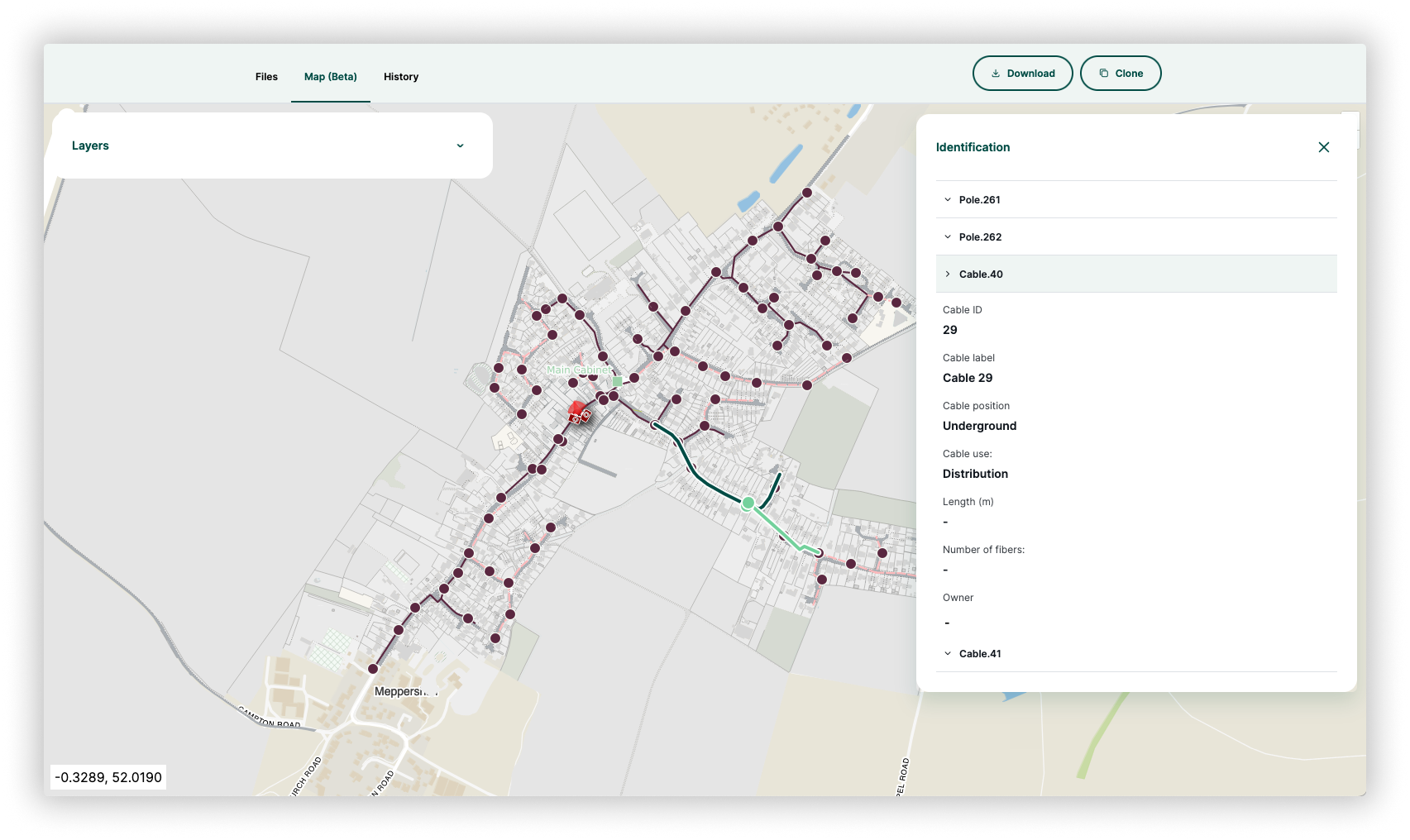
The app now respects QGIS sorting rules when listing features from a specific layer. Navigate to “Layers -> select a layer”, and the feature list will follow the sorting set in QGIS. Sorting can be set in QGIS by clicking a column to toggle between ascending or descending order, or set a custom sort expression through the popup menu. The sorting order is saved in the QGIS project file and will be automatically applied in the app.
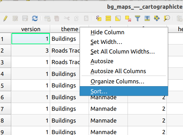
We’ve added support for ordering entries by value in value relation widgets. To enable this feature, simply check the option in the QGIS layer’s attribute form configuration. Once selected, the list will automatically be sorted by value. See the screenshot below for details.
Visit maps in a project detail to experience improved performance. We're continuously working to make them more efficient and reliable.
We brought back the option for centring to GPS position when entering the recording mode. Additionally, we added a new entry into the application settings to disable this behavior if desired.
We've integrated the Android Fused Location Provider into our app for enhanced location accuracy and efficiency. This update leverages all available location sources to provide faster and more precise location data while optimizing battery usage, ensuring your device stays powered longer. It is currently an opt-in feature, so you will need to enable it in the app settings under Manage GPS Providers. Enable this feature to enjoy improved location-based services and a longer-lasting battery with our latest enhancement!
We are introducing a new type of workspace role and project permission called "Editor". Editors in your workspace will be able to work on your projects without the risk of breaking your GeoPackage layers and QGIS project files.
How does it work?
✅ Editors can:
Add, update, and delete features in your projects
Use the mobile app and the QGIS plugin
Add new files, except for QGIS project files
Edit files, except for QGIS project files and GeoPackages (without changing the layer schema)
Remove files, except for QGIS project files and GeoPackages
⛔️ Editors cannot:
Manipulate QGIS project files, including changing symbology, adding/removing layers, or updating forms. Any changes to a QGIS project file will not be synchronized and will be overridden if the server version of the QGIS project file changes.
Remove GeoPackages
Make changes in GeoPackages that would result in creating conflicted copies, such as adding new columns or layers
Who is this new permission type suitable for?
This permission type is ideal for surveyors and others who need to add data without manipulating layer schemas and QGIS project settings.
Next steps
Please upgrade your QGIS plugin to the latest version and head to our dashboard
Editor permission is available on Cloud and Enterprise edition servers.
Read more details in the blog post or in our documentation.
Feeling unheard in GIS work? Mergin Maps streamlines data collection, collaboration, and sharing QGIS projects with a new Editor role for field surveyors.
Agrimotion, an agricultural consultancy in South Africa, specializes in perennial crops. Their IMPI platform, developed with Lutra Consulting and Mergin Maps, simplifies farm management by enhancing data collection and analysis, boosting productivity, and reducing costs.
PDF and other files can now be opened from within the feature form. Use an HTML link with the address project://<path_to_file_within_project> to open packaged files! HTML links can be placed inside an HTML widget or a multiline text editor.

The mobile app is now capable of opening GeoTIFF files compressed with zstd format.
We're excited to announce significant updates to our ecosystem. Over the past few months, we've dedicated ourselves to redesigning both the mobile app and dashboard, aiming to enhance your overall experience.
Don’t miss out on this opportunity to win a free seat at an upcoming Mergin Maps Admin Essentials training.
If you prefer using text mode for relations instead of the gallery mode, add “nogallery“ text to your relation editor title. The mobile app will then display text mode instead of gallery. The fix is now released in 2024.1.0.
Added a new feature allowing you to identify nearest features on the map by clicking and holding. Upon holding the click, you now receive a list of the nearest features. Click one to identify it!
Released as a part of the latest mobile app (2024.1.0)

We are excited to announce the release of a redesigned version of our mobile app. This release includes the following:
New, redesigned app visuals
Easier access to streaming mode with the new map button
The app no longer automatically centers to position when adding new features
Auto-centering to GPS is now accessible by clicking the GPS button
Thank you for your continued support and feedback! You can read a detailed list of changes here or our redesign blog post here. We also recorded an overview video showcasing these changes.
