Movement data in GIS #14: updates from GI_Forum 2018
Last week, I traveled to Salzburg to attend the 30th AGIT conference and co-located English-speaking GI_Forum. Like in previous year, there were a lot of mobility and transportation research related presentations. Here are my personal highlights:
This year’s keynotes touched on a wide range of issues, from Sandeep Singhal (Google Cloud Storage) who – when I asked about the big table queries he showed – stated that they are not using a spatial index but are rather brute-forcing their way through massive data sets, to Laxmi Ramasubramanian @nycplanner (Hunter College City University of New York) who cautioned against tech arrogance and tendency to ignore expertise from other fields such as urban planning:
One issue that Laxmi particularly highlighted was the fact that many local communities are fighting excessive traffic caused by apps like Waze that suggest shortcuts through residential neighborhoods. Just because we can do something with (mobility) data, doesn’t necessarily mean that we should!
Not limited to mobility but very focused on open source, Jochen Albrecht (Hunter College City University of New York) invited the audience to join his quest for a spatial decision support system based on FOSS only at bit.ly/FiltersAndWeights and https://github.com/geojochen/fosssdss
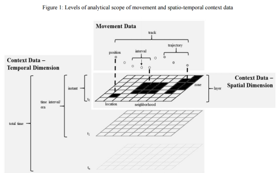
The session Spatial Perspectives on Healthy Mobility featured multiple interesting contributions, particularly by Michelle P. Fillekes who presented a framework of mobility indicators to assess daily mobility of study participants. It considers both spatial and temporal aspects of movement, as well as the movement context:

Figure from Michelle Pasquale Fillekes, Eleftheria Giannouli, Wiebren Zijlstra, Robert Weibel. Towards a Framework for Assessing Daily Mobility using GPS Data. DOI: 10.1553/giscience2018_01_s177 (under cc-by-nd)
It was also good to see that topics we’ve been working on in the past (popularity routing in this case) continue to be relevant and have been picked up in the German-speaking part of the conference:
Of course, I also presented some new work of my own, specifically my research into PostGIS trajectory datatypes which I’ve partially covered in a previous post on this blog and which is now published in Graser, A. (2018) Evaluating Spatio-temporal Data Models for Trajectories in PostGIS Databases. GI_Forum ‒ Journal of Geographic Information Science, 1-2018, 16-33. DOI: 10.1553/giscience2018_01_s16.
My introduction to GeoMesa talk failed to turn up any fellow Austrian GeoMesa users. So I’ll keep on looking and spreading the word. The most common question – and certainly no easy one at that – is how to determine the point where it becomes worth it to advance from regular databases to big data systems. It’s not just about the size of the data but also about how it is intended to be used. And of course, if you are one of those db admin whizzes who manages a distributed PostGIS setup in their sleep, you might be able to push the boundaries pretty far. On the other hand, if you already have some experience with the Hadoop ecosystem, getting started with tools like GeoMesa shouldn’t be too huge a step either. But that’s a topic for another day!
Since AGIT&GI_Forum are quite a big event with over 1,000 participants, it was not limited to movement data topics. You can find the first installment of English papers in GI_Forum 2018, Volume 1. As I understand it, there will be a second volume with more papers later this year.
This post is part of a series. Read more about movement data in GIS.