Related Plugins and Tags

QGIS Planet

Newly-Committed QGIS 3.0 Algorithm: Raster Layer Unique Values Report

Getting a pixel count and area size of unique values for a given raster layer hasn’t been straightforward in QGIS. The user could either go through third-party solutions via processing with some limitations, or create a (slow) python script.

That is, until now. Say hello to the newly-committed processing algorithm, the “raster layer unique values report”.

The QGIS algorithm will take a raster layer as input and output an HTML formatted report listing the pixel count and area size – in the raster layer’s unit - for all unique values. Thanks to QGIS core developer Nyall Dawson’s fantastic work on the processing platform in upcoming QGIS 3.0, the algorithm is written in C++ and therefore much faster - over a tenfold improvement - to an equivalent python script.

Using QGIS’ processing modeler, users can come up with a simple model to provide unique values reports within areas of interests, defined through vector polygons: Simple processing model in QGIS 3.0

For example, using the newly-updated 2016 Global Forest Change dataset and the model above, we can quickly generate a deforestation per year chart. Simply reproject the dataset in the appropriate meter-based projection, clip it with a national boundaries polygon, et voila. Paste the resulting HTML table into your favorite spreadsheet program and enjoy the charts: Algorithm HTML output in spreadsheet view

Coming soon in QGIS Part 2 – Color control for raster layers

Continuing on from part 1, another feature I’ve recently pushed to QGIS is the ability to control the hue, saturation and colour of a raster layer. This builds off the excellent work done by Alexander Bruy (who added brightness and contrast controls for raster layers), and it’s another step in my ongoing quest to cut down the amount of map design tweaking required outside of QGIS. Let’s step through these new features and see what will be available when version 2.0 is released in June…

First up is the ability to tweak the saturation of a layer. Saturation basically refers to the intensity of a colour, with low saturation resulting in a more washed out, greyer image, and high saturation resulting in more vibrant and colourful images. Here’s a WMS layer showing an aerial view of Victoria at its driest, least appealing and most bushfire ready state:

Original layer

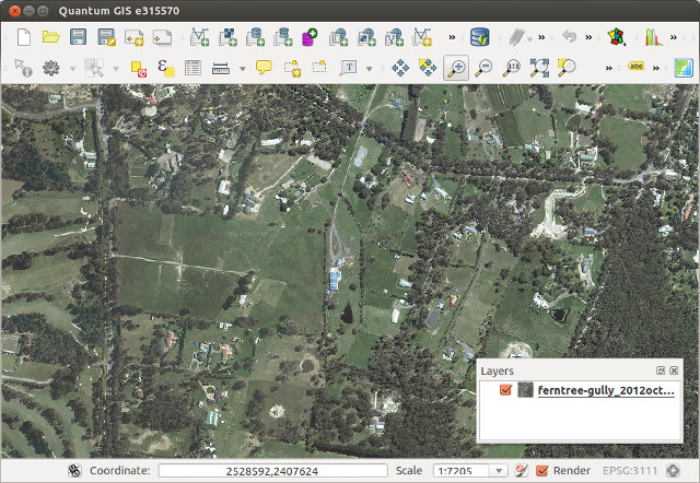
Raster layer before saturation controls…

Let’s tweak the saturation a bit to see if we can make it more appealing. In the Style tab under raster layer properties, you’ll see a new “Saturation and hue” section. For this layer I’ll bump the saturation up from its default value of zero:
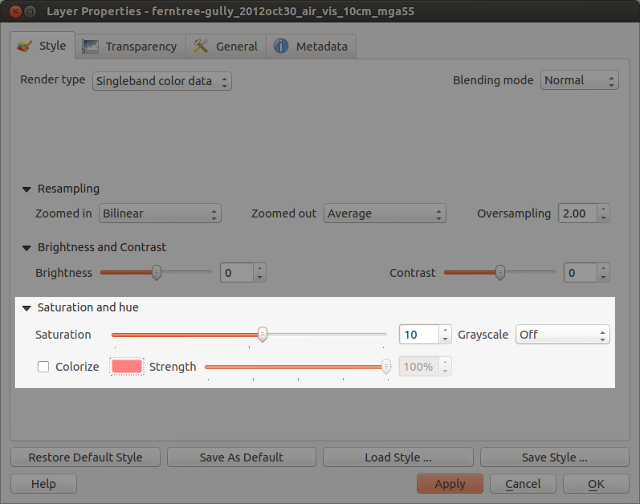
Saturation settings

Saturation settings

Which results in something like this:

Resultant layer!

… and after increasing the saturation!

Ah, much better. This actually looks like somewhere I’d like to live. A bit over-the-top perhaps, but it IS handy to make quick adjustments to raster colours in this way without the need for any external programs.

How about turning an image grayscale? I regularly have to do this with street directory basemaps, and until now couldn’t find a satisfactory way of doing this in QGIS. Previously I’ve tried using various command line utilities, but never found one which could turn an image grayscale without losing embedded georeferencing tags. (I did manage to achieve it once in QGIS using a convoluted approach involving the raster calculator and some other steps I’ve thankfully forgotten.)

But now, you can forget about all that frustration and quickly turn a raster grayscale by using a control right inside the layer properties! You even get a choice of desaturation methods, including lightness, luminosity or average. Best part about this is you can then right click on the layer to save the altered version out to a full-resolution georeferenced image.

grayscale

Street map in grayscale… woohoo!

Lastly, there’s the colourise option. As expected, this behaves in a similar fashion to the colourise tools in GIMP and Photoshop. It allows you to tint a layer to a specified colour. Let’s take a WMS layer of Melbourne, tweak the brightness and contrast, and colourise it blue…

colorize_settings

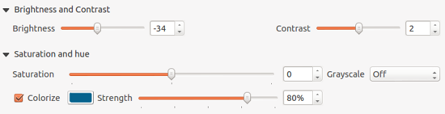
Tweaking the colourize settings

… and the end result wouldn’t be out of place in Ingress or some mid 90′s conspiracy flick!

colorized

Colorized WMS layer

These changes are just a tiny, tiny part of what QGIS 2.0 has to offer. It’s looking to be a sensational release and I can’t wait for final version in June!

Generating contours using GDAL ( via shell or QGIS)

I tell you. It always amazes me how much cool stuff you can do with great open source GIS software these days. GDAL is one of those great open source projects that I have just found a great use for (apart from just opening every raster type under the sun in QGIS).

GDAL has the ability to generate contours from a DEM, something that I have always wanted to try for my town but have never been able due to lack of a good DEMs.

Recently we purchased a set of DEMs that cover a large area as part of a study. Each DEM uses a grid size of 1mx1m. Prefect for generating contours.

Using the GdalTools QGIS plugin.

First make sure that you have the latest version of the GdalTools plugin installed (GdalTools should be installed by default with QGIS. If it’s not, search “Gdal” in the plugin installer). Enable the plugin once it’s installed.

Load the DEM into QGIS using the Load Raster icon.

DEM loaded in QGIS

Now head up to the menu Raster->Extraction->Contour

Raster menu in QGIS

Select the settings that you need. For this DEM I am going to generate 250mm contours.

Contour dialog.

Take note of the text area at the bottom of the dialog as that is the exact command sent to GDAL in order to generate the contours. If you take a copy of that you can run it on the command line for batch processing later.

Hit ok.

250mm contours from the DEM

BAM! :)

Using the command line/shell.

Using QGIS for a one off DEM is fine and dandy but what if you have 3000 DEMs that you need to process. To hell with doing that by hand!

Remember the contour tool in QGIS told us the exact command line args to use, so creating a shell script for automating the process is pretty easy.

for f in *.asc
do
  echo "Processing $f"
 gdal_contour -a ELEV -i 0.25 $f $f-250mm.shp
done

The above code will loop though the current directory and process all the DEMs generating 250mm contours for each one. It saves each new contour file as {filename}-250mm.shp. You will need to change *.asc to whatever format your DEM is in.

Copy the above code into a file somewhere and call it generate_contours.sh. This can then be called from the command line using

sh generate_contours.sh

Running sh on Windows

If you’re a windows user you will need to run OsGeo4W Shell in order to use sh.

Loading OsGeo4w shell.

Once the shell is loaded you can just call:

sh generate_contours.sh

Output from running generate_contours.sh

Final remarks

I ran the above sh script on a folder with about 2500 DEMs and it took around 4 hours to complete the whole folder. Of course performance will vary but it seems pretty quick considering.

Once again the possibly to use open source GIS tools to get my work done is amazing.  No expensive software here.

So far I’m not aware of any line smoothing/generalizing abilities using GDAL/OGR.  Although you can import the contours into GRASS and use that: http://grass.osgeo.org/wiki/V.generalize_tutorial

You can also generate the contours using GDAL via Python but that is a topic for another day.


Filed under: Open Source, qgis Tagged: contours, DEM, FOSSGIS, gdal, gis, grid, ogr, Open Source, osgeo, qgis, Quantum GIS, raster

Getting ECW and MrSID support working in QGIS dev OSGeo4W install

Note:  This post is about getting ecw and mrsid support working in the trunk (qgis-dev) version of QGIS which is installed with the OSGeo4W installer.  Non-dev versions seem to work fine following this method: http://www.qgis.org/wiki/OSGeo4wSetup#Installing_support_for_raster__.2A.ECW_.28ERMapper.29_and_.2A.sid_.28MrSid.29_formats

Getting ECW and MrSID support into QGIS can be a real pain in the butt when you first try; but once you know how it’s easy.

If you try to open a ecw file in QGIS you will get this nice little error message:

What?  I thought QGIS supported ECW files!

Turns out it does, but the team are not able to ship the required libs with the program due to licensing restrictions by ERDAS.   Luckily adding support is not “too” hard.

  1. First head over to http://www.erdas.com/products/ERDASECWJPEG2000SDK/Downloads.aspx
  2. Click Download Now for the ERDAS ECW/JP2 SDK Desktop Read-Only, Version 4.1 libs,
  3. Fill out a bit of registration details and click though all the pages (this is the most painful process I have ever had to go though to get some libs for a program, ERDAS should be ashamed that it is such an effort.)
  4. Once you have download ECWJP2SDKSetup_RO_20100920.exe; install it.
  5. Copy all the files from C:\Program Files\ERDAS\ERDAS ECW JPEG2000 Read SDK\bin\vc90\win32 into the bin folder of your OSGeo4W install (default is C:\OSGeo4W\bin)
    You can open the OSgeo4W shell and run: copy “C:\Program Files\ERDAS\ERDAS ECW JPEG2000 Read SDK\bin\vc90\win32\*.dll” %OSGEO4W_ROOT%\bin to do the same thing.
  6. Launch osgeo4w-setup.exe, the installer that you used to install qgis-dev,  and select  gdal-ecw, gdal17-ecw and gdal-mrsid, gdal17-sid under the libs section. Let it install the needed libs and any dependencies.
  7. Open %OSGEO4W_ROOT%\bin and search for qgis-dev.bat; open it with a text editor and add the following line:
    set GDAL_DRIVER_PATH=”%OSGEO4W_ROOT%”\bin\gdalplugins\1.8
    I always insert it just after  SET OSGEO4W_ROOT=
  8. Launch qgis-dev.bat
  9. Open a ecw

ECW file opened in QGIS

I have tested this on a couple of machines now but as always

with no guarantee that it will work on yours :)  (Although it should)


Filed under: Open Source, qgis Tagged: ecw, gis, mapping, mrsid, Open Source, qgis, Quantum GIS, raster

  • Page 1 of 1 ( 4 posts )
  • raster

Back to Top

Sustaining Members