Introducing the Latest Style User Interface Improvements
Yesterday, Martin Dobias announced that Arun’s GSoC work on QGIS symbology has been merged into the developer version. So let’s have a look at todays nightly-build!
I’ll step through the features mentioned in the announcement to see how they look and work:
1. Style manager has been greatly improved: grouping of symbols, tagging, “smart” groups (showing only symbols matching some criteria), search
On opening new Style Manager, we can already see that it has changed considerably: There are groups on the left, tags at the bottom and a search field in the upper right corner.
New groups are created with the “+” button and styles can be added using the context menu:
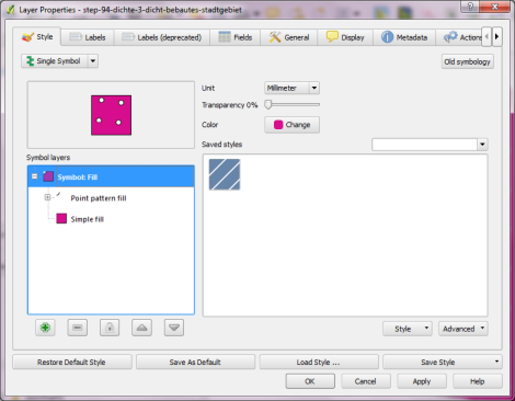
2. Symbol selector and properties dialogs have been integrated to just one dialog, improving the usability a lot
Instead of opening tons of nested windows, complex styles can now be easily edited using the symbol layer tree on the left:
3. Style database is now stored in a SQLite database rather than an XML file for better scalability. You can import all your saved symbols and color ramps from ~/.qgis/symbology-ng-style.xml – from now they will be stored in ~/.qgis/symbology-ng-style.db.
Importing through Style Manager works like a charm. All styles will be imported into the given group.
4. Style import improvements: load style directly from given URL, saving imported symbols into a group
Instead of giving a path to a style XML, it’s also possible to specify a URL. That’s a great step towards shared symbol libraries!
5. SVG fill: shows directories for easier traversal through the SVG directories
Definitely a plus! It’s now much easier to work with big SVG symbol collections.
What a great result of this year’s Google Summer of Code for QGIS. Give these new features a try! I already fell in love with them.


