Related Plugins and Tags

QGIS Planet

2.7.2 - Heroic Hedgehog

Changes

🐛 Bug Fixes

  • Slightly higher rotation kickstart threshold to avoid accidental rotation while pinch zooming
  • Fix moving of features on rotated map canvas
  • Fix 'invalid relation' on fields with valid relations
  • Fix WFS provider on iOS

Reports from the winning grant proposals 2022

With the QGIS Grant Programme 2022, we were able to support four proposals that are aimed to improve the QGIS project, including software, infrastructure, and documentation. The following reports summarize the work performed in the proposals. 

  1. Support building QGIS application on Qt 6 (#243) – Report
    In addition to the original plan of porting the “gui” and “app” libraries to Qt 6, it was possible to complete also the “3d” and “server” libraries. We now are at a stage where the majority of QGIS builds and runs without any significant issues on Qt 6. The Github CI setup has been updated to also run the C++ tests for gui, app, server and 3d, and the majority of these have been fixed so that they pass on the Qt 6 builds too. In addition, some tests which were failing under Qt 6 revealed some real QGIS bugs which have been fixed in the process of this work. (So there’s a direct benefit for the existing Qt 5 builds too!).
  2. Add SQL Logging in the debugging/development panel (#242) – Report
    When debugging or developing a QGIS algorithm or a QGIS plugin and when investigating performances of a particular layer it is often useful to view the SQL commands that QGIS sends to the backend. The SQL logging was implemented for Postgres, GeoPackage, Spatialite and Oracle data providers. immagine
  3. QGIS setting registry follow-up (#245) – Report
    The work can mainly be seen here PR qgis/QGIS#51295 with the proposed approach to register settings in a hierarchical and organized way, without too much complexity in the API to actually use the settings.
    To have a clean approach, some keys have been renamed. There is a compatibility handling (both forward and backward). The GUI implementation will be worked on during the HF in NL this spring.
  4. Fix handling of provider default value clauses/Autogenerate/nextval(…) handling (#247) – Report
    The bulk of these changes landed in the QGIS 3.28 release. A quick way to demonstrate on of the issues fixed is: open a Geopackage file, start editing the layer, add some features to it, but don’t save the edits, then right click the edited layer and try to save it to a different file. On older QGIS releases you’ll be spammed with a number of error messages because we tried to write a string value of “Autogenerate” into a number field for all the newly created features. On QGIS 3.28 this all just works as expected, with no errors encountered.

Thank you to everyone who participated and made this round of grants a great success and thank you to all our sustaining members and donors who make this initiative possible!

Welcoming our first flagship sustaining member – Felt

It is with great pleasure that we would like to welcome Felt as our first flagship sustaining member!

Felt plays a revolutionary role for those who work with maps daily by making maps and spatial analysis more accessible across organizations through modern web-based collaboration features. Teams across planning, tech, infrastructure, consulting, environmental sciences and more are using QGIS & Felt to access the power of desktop GIS alongside the ease of modern web-based collaboration features, including:

  • Customize your maps with browser-based tools: draw, drop pins, leave notes, trace boundaries, find routes — even add a video — all just point and click
  • Collaborate with your team on the same map in the moment, or hours and miles apart
  • Invite one, a few, or the whole world to see your work with precise access controls

Have a look yourself and discover the inspiring maps shared by Felt users.

We are particularly excited about this collaboration since Felt users regularly pair the analytical power of QGIS with the team-based sharing and collaboration features of Felt. Together, we contribute to a winning ecosystem of easy-to-use map-making tools for modern teams and organizations.

Felt’s support for QGIS helps us reach the goal of a stable financial basis to ensure another 20+ years of sustainable development and keep bringing the most user-friendly GIS to users worldwide.

2.7.1 - Heroic Hedgehog

Changes

🚀 Features

  • New action to import a dataset of compressed project from a remote URL (see documentation)

🐛 Bug Fixes

  • Fix digitizing of 3D points on shapefile datasets when not locked to current GNSS position

FOSSGIS 2023

Sourcepole hat an der FOSSGIS 2023 in Berlin verschiedene Themen mit Vorträgen abgedeckt:

  • QGIS Web Client 2 (QWC2) - Neues aus dem Projekt
  • COPC, das neue cloudoptimierte Format für Point Clouds
  • Cloudoptimierte Formate für Kacheln und multidimensionale Rasterdaten
  • Geodatenverarbeitung mit Workflow-Engines

2.7.0 - Heroic Hedgehog

Changes

27

🚀 Features

  • Map canvas rotation support (via pinch rotation gesture and mouse middle button)
  • Audio and video attachment recording within the feature form
  • Audio and video attachment playback within the feature form
  • File attachment support added to the feature form
  • User interface dark theme styling (defaulting to current system default on Android)
  • User interface font scaling
  • A completely revamped non-native camera featuring zoom support, flash toggle, GPS location metadata, and a much better interface

Improvements

  • Default value expressions relying on aggregate() now work properly within the feature form
  • Image metadata values are now preserved when setting a maximum image size setting (via qfieldsync)
  • Feature form’s field labels will now respect the color and style overrides defined in project files
  • Upstream libraries updated, including brand new QGIS 3.30

🐛 Bug Fixes

  • Vertical grid datasets containing spaces in their paths now working

Summary of the 3D features & enhancements in QGIS 3.30

QGIS 3.30 was released late last week and we are pleased to announce the new features introduced as a part of our latest crowdfunding campaign to improve 3D, point cloud and elevation data.

Thank you

First and foremost, thanks to the generous support from the community to fund our work. Here is the list of our contributors in no particular order:

IGN (INSTITUT NATIONAL DE L’INFORMATION GEOGRAPHIQUE ET FORESTIERE), National Land Survey of Finland, Danish Agency for Data Supply and Infrastructure, K2 Engineering GmbH, ProScape Consulting, Västra Götalandsregionen, Kristianstads kommun, IGN FI, L’Arrière Guichet, Septima, QWAST-GIS, ATAPEX s.r.o., REDcatch GmbH, F.A.R.M. Facilitazioni Agroecologiche Regionali Mobili, EPYMA TERRITORIO Y MEDIO AMBIENTE, SL, GEO EXPLORATION LTD, Bohannan Huston, Inc., Lidar Guys, Neuchâtel- Service de la géomatique, Wooding Geospatial Solutions, Ville de Vevey, QGIS User Group Switzerland, Ecophylla Consulting, Refactor, Locate Press, Alta ehf, Oester Messtechnik GmbH, RUDAZ+PARTNER AG, BayesMap Solutions LLC, GEOACE, Natalie Gyles, Andreas Neumann, Dougal Munro, Spatial Thoughts, Cicada Systems GIS Consulting, Cori Hermle, Powell Asset Mapping LLC, Darren Farmer, Greg Hall, Ecothought Pty Ltd, Gabriel Diosan, Bhutan QGIS Group, Ultimatum Finesse, Balanced Risk Strategies, Ltd, Concordia University, Burmis Studio Inc., Nicholas Hadaller, Angello Villatoro, Yoichi Kayama, Hennessy Amor Becerra Ayala, Flow Design Limited, BNHR.XYZ, Roberto Moyano, Benjamin Kuster, Goldspot, North River Geographic Systems, Inc, David W. Wormuth, Victor Graphics, Valley Spatial, Stephen Mather, SANTIAGO AURELIO MOTA, Kelly Crowell, Brian Duhan, Paddy Fisher, OSGEO:UK, Christian Gugl, GIP CRAIG - Centre Régional Auvergne-Rhône-Alpes de l’Infromation Géographqiue, Raphael Mabit, Tibor Lieskovský, Kerstin Fohlert, Zhan Li, Bernd Vogelgesang, Marlin Müller, Johannes Bonekamp, Stefan Giese, Fabian Faßnacht, QGIS Sweden user group, Falo, DAVID GARCIA HERNANDEZ, Lint Data and Geospatial, Cliff Sin Wai Lau, Grzegorz Sapijaszko, Łukasz Rapa, Alessandro Pintucci and Maarten Pronk.

Our gratitude also goes to those who want to remain anonymous.

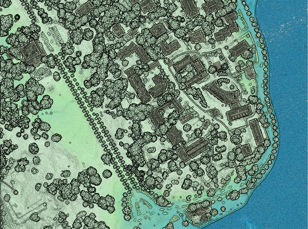
Global map shading
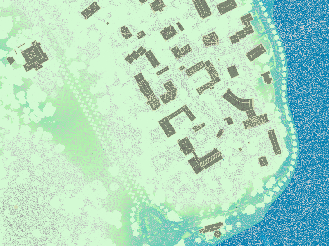
Map data without global terrain shading

Global terrain shading for point clouds, dem and vectors

To see this feature in action, you can open QGIS project properties and under Terrain, there should be an option for Global Map Shading. You will need to first add a raster as your DEM under the Terrain section.

Elevations of all these layers are combined and the considered elevation is chosen depending on one of two methods:

  1. the highest elevation between raster, mesh or point cloud layers will be selected.
  2. elevation will be selected based on the order of layers in the layer panel.

Depending on the context and the use of the map the user can choose the more appropriate method.

For now, the shading methods implemented are the Eye Dome Lighting and the hill-shade. More methods could be added in the future - such as ambient occlusion.

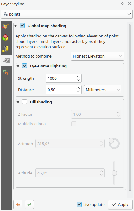
The user can choose the elevation shading settings in a specific UI widget that can be found in two places:

  1. under the Project Properties, within the same tab of the project elevation settings.
  2. under the Styling Panel, a new tab is added for quick access to the user.
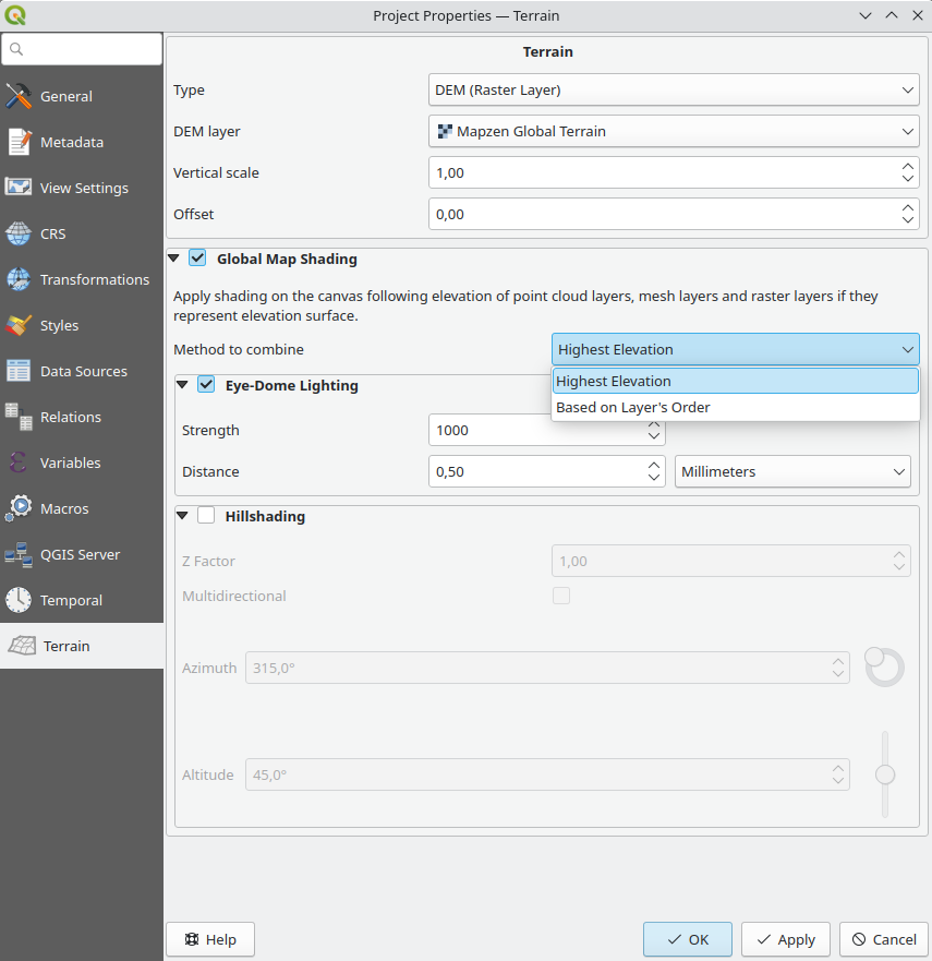
Global terrain shading settings in project properties

Global terrain shading settings in style panel

Profile elevation within print composer

This work was carried out by our collaborator North Road. The profile tool can embed elevation profiles within print layouts. It is possible to add beautifully styled profiles in your print outputs.
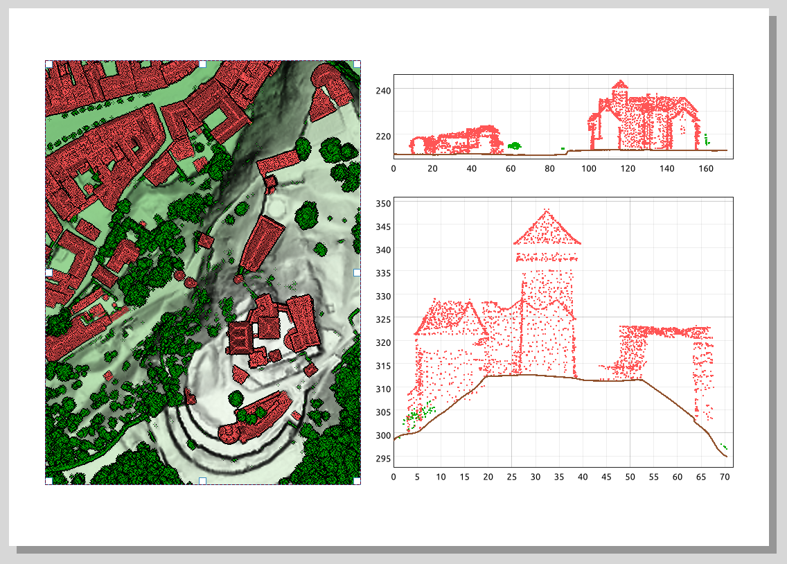
Embeding elevation profile in the print composer

To use elevation profiles in print layouts, simply click the Add Elevation Profile button icon elevation profile in print composer in the toolbar, and then to initialize it, copy profile configuration from an existing elevation profile from QGIS main window using the “Copy From Profile” button.
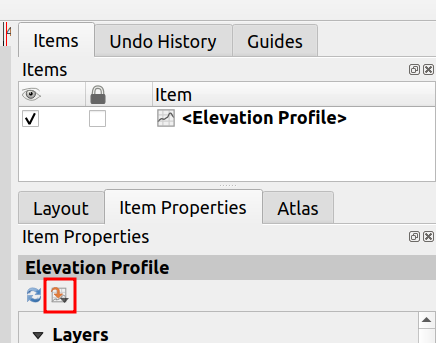
Elevation profile settings in the print composer

3D navigation improvements

With the new improvements, you can:

  1. move camera vertically using ctrl+shift+left mouse button
  2. keep zooming with the wheel while moving the mouse
  3. continue right mouse button zooming when pointer exits the viewport

Improve zoom-extents in 3D

The terrain’s and point cloud layers’ elevation range are taken into account so that the camera is not positioned below the scene’s contents, which was the case when using the terrain’s vertical scale setting to exaggerate the elevation differences.

Limit 3D scenes’ 2D extent

3D Views can now be limited to a specific 2D extent. The terrain is clipped and no 3D features beyond that extent are loaded, making it easy to render specific areas of big QGIS projects. The project’s 2D extent is used by default which can then be adjusted in each 3D view separately using the new General tab in 3D configuration.
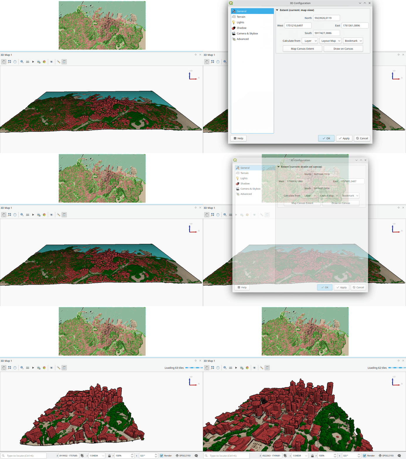
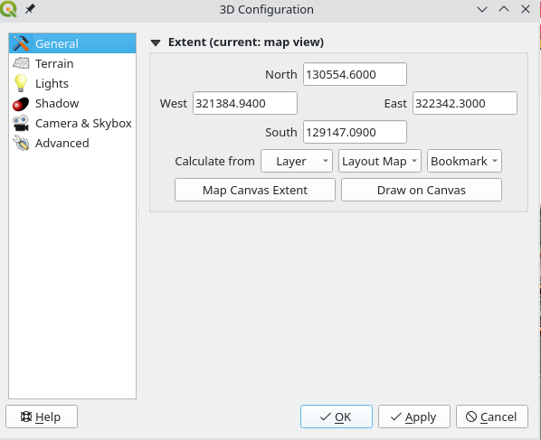
Limiting 3D map extent

Limiting 3D map extent

Future updates

There will be more features planned for QGIS 3.32. We are finalising the Processing framework for point cloud data and it should be available on QGIS master in coming weeks.

Please do not hesitate to contact us if you have any suggestions to improve QGIS 3D and point cloud support.

How Oslandia invests in OpenSource

You may be wondering where Oslandia’s name is coming from ? Or maybe you already know ? In this article we focus on the “OS” part of Oslandia : OpenSource !

Oslandia positions itself as IT expert in the field of OpenSource geographical information systems. QGIS is namely one of the proheminent opensource softwares for the geospatial industry. This position is a key element of our business model.

But do you know how we work behind the scene ? This article will give you an opportunity to discover some of our contributions to the OpenSource ecosystem.

Principles

Our general business model is based on projects we carry out for our clients. They fund us to design and implement solutions adapted to their needs and requirements. Part of these developments consist in core development of Opensource software. This allows us to contribute actively to FOSS4G components.

But this funding method makes it complicated to fund maintenance, or new exploratory developments, as well as communication, community management or other tasks necessary for healthy opensource projects.

As a consequence, we introduced at Oslandia a mechanism of internal OpenSource project grants.

These grants constitute self-investment from the company into the OpenSource ecosystem, and can be applied to new projects, research and development or existing projects.

This mechanism has multiple interests :

  • For opensource projects : maintenance and new contributions
  • For Oslandia : image and potential new business opportunities
  • For the team : work on projects that matter to them

These OpenSource grants consist in a large range of possible tasks, as we often say : “Opensource projects are not only code”. Instead of developers, we prefer the term contributors. Development, code review, maintenance, documentation, community management, communication, each collaborator can choose the type of task to focus on.

We differentiate software maintenance grants and opensource project grants. We call the latter “OpenSource mini-projects

Software maintenance consists in refactoring, bugfixing, packaging, release management… All these tasks need dedicated time which is difficult to fund directly on client’s project.

Opensource mini-projects grants are specific opensource proposal which can be submitted by any collaborator on any subject. We then vote on the best proposal and the team can start working on the subject within the allocated budget.

Some numbers

We allocate around 5% of the global production time to software maintenance grants. Our Opensource maintenance grant for 2022 is therefore approximately 190 days of work. It mainly focus on QGIS, PostGIS, QWC2, Giro3D and a few other components we actively maintain.

We also allocate 5% of the global production time to opensource mini-projects grants. It represents an additional 190 days of work for 2022.

Oslandia therefore invests almost 400 days of work into the OpenSource ecosystem, outside of direct contributions for client’s projects.

Opensource Mini-projects

OpenSource mini-projects grants are submitted by Oslandia’s collaborators and focus on various task and thematics : innovation, development, design, prototyping, communication or any other kind of Opensource contribution.

Proposals have to define goals, deliverables, planning, team and needed budget. Then we evaluate the proposals given the following criteria :

  • proposal coherency ( e.g. deliverables vs budget )
  • alignment with Oslandia’s strategy
  • innovation level
  • business opportunities
  • fun and motivation
  • impacts in terms of communication
  • links with other projects at Oslandia
  • possibility of extra R&D funding

We then vote on best proposal and manage these mini-projects just as a client project.

Examples

QGIS

The maintenance grant on QGIS allowed us to work on the following tasks :

  • Bugfixing
  • Code review for PRs submitted by other developers
  • Code refactoring
  • Documentation
  • Packaging pipeline
  • OSGeo4W improvement

OpenSource mini-projects grants

During the year of 2022, we worked on the following mini-projects :

In 2023 we will continue to work on these projects, and others ! for example pg_featureserv, py3dtiles, infoclimat website, MapProxypgRouting

Conclusion

This investment mechanism allows Oslandia to be an opensource “pure player” and contribute actively to these OpenSource projects and to the OpenSource ecosystem as a whole.

Should you be interested in our contribution model, or if you have any question regarding our internal OpenSource grant program, do not hesitate to contact us : [email protected] !

QGIS 3.30 ‘s-Hertogenbosch is released!

We are pleased to announce the release of QGIS 3.30 ‘s-Hertogenbosch!

Installers for all supported operating systems are already out. QGIS 3.30 comes with tons of new features, as you can see in our visual changelog. QGIS 3.30 ‘s-Hertogenbosch is named after this year’s QGIS user conference and contributor meeting host city.

We would like to thank the developers, documenters, testers and all the many folks out there who volunteer their time and effort (or fund people to do so). From the QGIS community we hope you enjoy this release! If you wish to donate time, money or otherwise get involved in making QGIS more awesome, please wander along to qgis.org and lend a hand!

QGIS is supported by donors and sustaining members. A current list of donors who have made financial contributions large and small to the project can be seen on our donors list. If you would like to become a sustaining member, please visit our page for sustaining members for details. Your support helps us fund our six monthly developer meetings, maintain project infrastructure and fund bug fixing efforts.

QGIS is Free software and you are under no obligation to pay anything to use it – in fact we want to encourage people far and wide to use it regardless of what your financial or social status is – we believe empowering people with spatial decision making tools will result in a better society for all of humanity.

Getting ready for our user conference and contributor meeting in ‘s-Hertogenbosch

In a few weeks, our 25th Contributor Meeting and International QGIS User Conference uc2023.qgis.nl will take off on 18 April.

Register or become a speaker yourself. For details on all the exciting opportunities to get involved, check out the introduction by our awesome organizing team:

Tracking geoprocessing workflows with QGIS & DVC

Today’s post is a geeky deep dive into how to leverage DVC (not just) data version control to track QGIS geoprocessing workflows.

“Why is this great?” you may ask.

DVC tracks data, parameters, and code. If anything changes, we simply rerun the process and DVC will figure out which stages need to be recomputed and which can be skipped by re-using cached results.

This can lead to huge time savings compared to re-running the whole model

You can find the source code used in this post on my repo https://github.com/anitagraser/QGIS-resources/tree/dvc

I’m using DVC with the DVC plugin for VSCode but DVC can be used completely from the command line, if you prefer this appraoch.

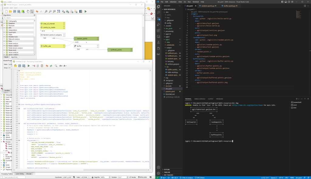
Basically, what follows is a proof of concept: converting a QGIS Processing model to a DVC workflow. In the following screenshot, you can see the main stages

  1. The QGIS model in the upper left corner
  2. The Python script exported from the QGIS model builder in the lower left corner
  3. The DVC stages in my dvc.yaml file in the upper right corner (And please ignore the hello world stage. It’s a left over from my first experiment)
  4. The DVC DAG visualizing the sequence of stages. Looks similar to the QGIS model, doesn’t it ;-)

Besides the stage definitions in dvc.yaml, there’s a parameters file:

random-points:
  n: 10
buffer-points:
  size: 0.5

And, of course, the two stages, each as it’s own Python script.

First, random-points.py which reads the random-points.n parameter to create the desired number of points within the polygon defined in qgis3/data/test.geojson:

import dvc.api

from qgis.core import QgsVectorLayer
from processing.core.Processing import Processing
import processing

Processing.initialize()

params = dvc.api.params_show()
pts_n = params['random-points']['n']

input_vector = QgsVectorLayer("qgis3/data/test.geojson")
output_filename = "qgis3/output/random-points.geojson"

alg_params = {
    'INCLUDE_POLYGON_ATTRIBUTES': True,
    'INPUT': input_vector,
    'MAX_TRIES_PER_POINT': 10,
    'MIN_DISTANCE': 0,
    'MIN_DISTANCE_GLOBAL': 0,
    'POINTS_NUMBER': pts_n,
    'SEED': None,
    'OUTPUT': output_filename
}
processing.run('native:randompointsinpolygons', alg_params)

And second, buffer-points.py which reads the buffer-points.size parameter to buffer the previously generated points:

import dvc.api
import geopandas as gpd
import matplotlib.pyplot as plt

from qgis.core import QgsVectorLayer
from processing.core.Processing import Processing
import processing

Processing.initialize()

params = dvc.api.params_show()
buffer_size = params['buffer-points']['size']

input_vector = QgsVectorLayer("qgis3/output/random-points.geojson")
output_filename = "qgis3/output/buffered-points.geojson"

alg_params = {
    'DISSOLVE': False,
    'DISTANCE': buffer_size,
    'END_CAP_STYLE': 0,  # Round
    'INPUT': input_vector,
    'JOIN_STYLE': 0,  # Round
    'MITER_LIMIT': 2,
    'SEGMENTS': 5,
    'OUTPUT': output_filename
}
processing.run('native:buffer', alg_params)

gdf = gpd.read_file(output_filename)
gdf.plot()

plt.savefig('qgis3/output/buffered-points.png')

With these things in place, we can use dvc to run the workflow, either from within VSCode or from the command line. Here, you can see the workflow (and how dvc skips stages and fetches results from cache) in action:

If you try it out yourself, let me know what you think.

Plugin Update January 2023

This month has been busy with 20 new plugins in the QGIS plugin repository.

Since it can be challenging to stay up to date, our monthly plugin update provides you a quick overview of the newest plugins. If any of the names or short descriptions piques your interest, you can find the direct link to the plugin page in the table below the screenshot.

ThreePointMethod
Determine the orientation of geological surfaces using the three-point vector method.
japanGeology3
japanGeology3
CartoDruid Synchronizer
Plugin to synchronize SQLite databases to Cartodruid Synchronization services at ITACyL
eTracability Automatic Accountability Tracker
This plugin adds automatic attributes to vector layers, that track who updated or created features, and when.
MINDED FBA
An automatic remote sensing tool for the estimation of flooded and burned areas.
QKan
Gruppe der QKan-Erweiterung(en)
MAGIC Map Loader
This plugin will open the DEFRA MAGIC Map service on the area of your map canvas
Full MCE for Public Health
Full Multicriteria Evaluation tool for Public Health
Lat lon buffer
This processing plugin makes a buffer in meters around lat lon point features
Equi Processing
Equidistance algorithme
Qpip
Qgis Pip Management
Geo-Zone Check Germany
UAS flight restriction checker for Germany
NIB-ortofoto-prosjekt
Henter alle ortofoto-prosjekt fra Norge i bilder (WMS) som ligger innafor et utsnitt.
Kauko työkalut
Kauko työkalut
Plan Creator 3
Tool for creating a digital building model Инструмент создания цифровой модели здания
Project Reports
Plugin to generate reports (CSV and HTML) of properties and metadata about layers, fields and layouts of QGIS projects.
Kartverket adresse-API
This plugin fetches coordinates for Norwegian addresses using the Kartverket open adress-API
SenseHawk QC
This plugin will load and save SenseHawk projects needing quality check.
Polygon from map extent
A lightweight QGIS plugin to make a polygon from the current map extent.
Equirectangular 360° Viewer
Equirectangular and 360° streetview like image viewer

Status Update on 2023 Crowd-Funding

An amazing 30 new sustaining members have already answered our crowd-funding call raising total member contributions to €158,000 annually.

We are particularly happy to welcome our first medium-level university sustaining member, the University of Zurich, Department of Geography:

New medium sustaining members

Institut Dr. Nowak GmbH, Germany
Bohannan Huston, New Mexico, USA
University of Zurich, Department of Geography
Idrostudi srl, Italy

New small sustaining members

  • Pacific Geomatics Limited, Canada
  • Helix Resources Limited, Australia
  • Sand Hill Geographic, Virginia, United States
  • GIS Pro Western Australia
  • The Spatial Distillery Company, Victoria, Australia
  • Qwast-GIS, The Netherlands
  • CEICOL, Colombia
  • QGIS user group Norway
  • Robex resources, Quebec, Canada
  • analyGIS GmbH, Switzerland
  • CartoExpert, France
  • addresscloud, UK
  • Baugeologie und Geo-Bau-Labor AG, Switzerland
  • Spatial Thoughts, India
  • Centremaps, UK
  • Geoideal, Colombia
  • theworksLA, California, United States
  • SoftWater s.r.l., Italy
  • menz umweltplanung,Germany
  • Oy Arbonaut Ltd, Finland
  • ZevRoss Spatial Analysis, New York, United States
  • Ecophylla Consulting, Ontario, Canada
  • DeBeer&DeVos BV, Belgium
  • Reuther NetConsulting, Germany
  • H13, Denmark
  • Rockwater Pty Ltd, Australia

Even with this impressive list of new members, we also realize that we have not reached the campaign goals yet and that potential large and flagship members may need more time to respond.

Our funding progress so far:

Therefore, we are extending the campaign until the end of March 2023.

Become a sustaining member or donor. Every contribution counts.

Details: Sustaining Membership Program Overview

2.6.3 - Geeky Gecko

Changes

🐛 Bug Fixes

  • Fix freeze occurring when zooming to a 1-point vector layer
  • Fix UUID editor widget not working when editable state is unchecked
  • Fix parenting of serial port receiver
  • Fix blurry 'show feature' button within the relation reference editor widget

QField 2.6: perfecting high-accuracy positioning

It’s only been a few weeks into the new year, but we’ve got great news for you: a brand new QField 2.6 “Geeky Gecko ?” has been released with a focus on positioning improvements, including Bluetooth support for Windows. And with that, we are delighted to remove the ‘beta’ status from QField for Windows.

New positioning features

Let’s open with a bang: QField 2.6 now supports NMEA streaming from external GNSS devices over TCP, UDP, and serial ports, in addition to preexisting Bluetooth connectivity. This new functionality means that QField is now compatible with a much larger range of GNSS devices out there.

These new receivers unlock NTRIP-driven centimetre accuracy for devices that use the Bluetooth connection to a manufacturer’s application to connect to NTRIP servers. In this scenario, QField could not initiate a Bluetooth connection since it was already taken. With the new TCP and UDP receivers – provided the manufacturer’s application offers NMEA streaming over either of those Internet protocols – QField can connect and consume high-accuracy positioning.

The presence of a serial port receiver provides support for external GNSS devices using Bluetooth on Windows via the virtual serial port created by the operating system. The lack of Bluetooth support on Windows was a long-wanted enhancement from QField users on that platform and was the last blocker for the ‘beta’ status to go away.

In addition, QField 2.6 allows users to pick from half a dozen metrics a value to attach to the measure (M) dimension of geometries being digitized when locked to the current position. This functionality is available to both users digitizing and the positioning tracker. The measurement values available as of 2.6 are timestamp, ground speed, bearing, horizontal accuracy and vertical accuracy, as well as PDOP, HDOP and VDOP values.

Growing Continuous Integration (CI) testing framework now covers positioning

Starting with version 2.6, QField ships with increased quality assurances thanks to the addition of tests covering positioning functionalities in its growing CI framework.

Practically speaking, this means that every single line of QField code changed is now being tested against positioning-related regression, significantly decreasing the risks of shipping a new version of QField with broken functionality in the area of antenna height, vertical grid shift, and ellipsoidal height adjustments.

We would like to commend Deutsche Bahn for funding the required work here. This could not have come in soon enough as more and more people are opting for QField and relying on it for their crucial day-to-day fieldwork.

2.6.0 - Geeky Gecko

🚀 New features

26_cover

  • A new external GNSS devices management system that allows users to save device 'presets' making it easier to switch from one device to another (#3768, funded by Deutsche Bahn)
  • A new pair of TCP and UDP receivers to support streaming of NMEA positioning data over IP (#3770, funded by Deutsche Bahn)
  • Ability to choose the measurement (M) value to attach to vertices when tracking positioning or when digitizing while locked to position (#3731)

Improvements

  • Greatly improved external GNSS device stability and reliability with new automated tests acting as safeguards against future regressions (#3771, #3781, funded by Deutsche Bahn)
  • Points created on 3D layers are now always 3D (with Z set to NaN if missing)
  • Shortcut to go to a QR Code encoded point with the 'geo:' prefix when scanning through the search bar
  • Printing of map layouts and atlases on iOS now works

2.6.2 - Geeky Gecko

Changes

🐛 Bug Fixes

  • Fix out-of-sync positioning device type combobox when adding a new device
  • Fix photo orientation not respected when applying maximum image size setting
  • Fix USB file transfer of photo attachments not working under some scenarios (involving creation of new directories)

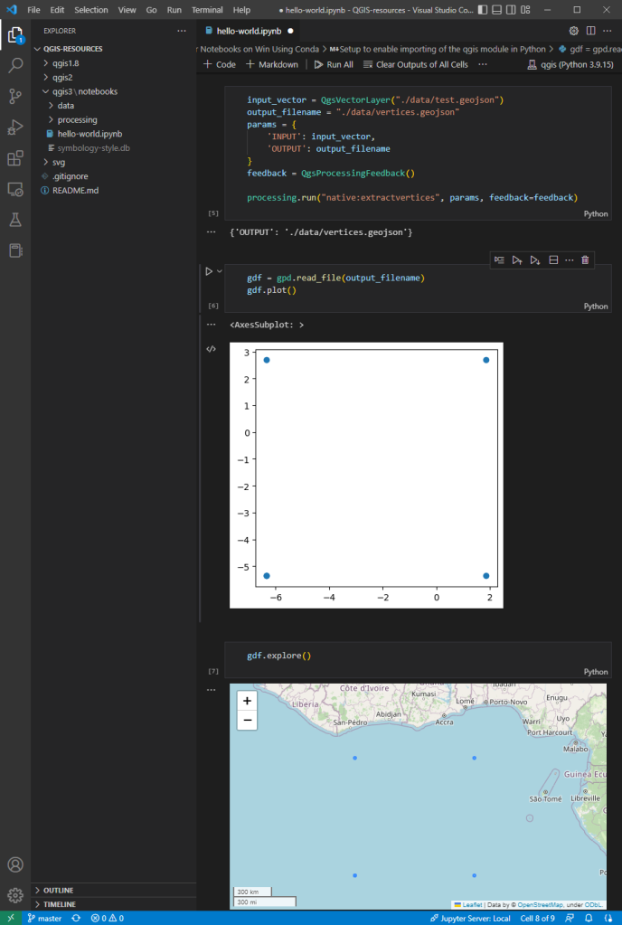
PyQGIS Jupyter notebooks on Windows using Conda

The QGIS conda packages have been around for a while. One of their use cases, for example, is to allow Linux users to easily install multiple versions of QGIS.

Similarly, we’ve seen posts on using PyQGIS in Jupyter notebooks. However, I find the setup with *.bat files rather tricky.

This post presents a way to set up a conda environment with QGIS that is ready to be used in Jupyter notebooks.

The first steps are to create a new environment and install QGIS. I use mamba for the installation step because it is faster than conda but you can use conda as well:

(base) PS C:\Users\anita> conda create -n qgis python=3.9
(base) PS C:\Users\anita> conda activate qgis
(qgis) PS C:\Users\anita> mamba install -c conda-forge qgis=3.28.2 
(qgis) PS C:\Users\anita> qgis

If we now try to import the qgis module in Python, we get an error:

(qgis) PS C:\Users\anita> python
Python 3.9.15 | packaged by conda-forge | (main, Nov 22 2022, 08:41:22) [MSC v.1929 64 bit (AMD64)] on win32
Type "help", "copyright", "credits" or "license" for more information.
>>> import qgis
Traceback (most recent call last):
  File "<stdin>", line 1, in <module>
ModuleNotFoundError: No module named 'qgis'

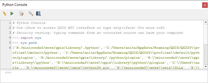
To fix this error, we need to get the paths from the Python console inside QGIS:

import sys
sys.path
['H:/miniconda3/envs/qgis/Library/./python', 'C:/Users/anita/AppData/Roaming/QGIS/QGIS3\\profiles\\default/python', ... ]

This list of paths can be configured as the defaults for our qgis environment using conda develop:

(qgis) PS C:\Users\anita> conda activate base
(base) PS C:\Users\anita> mamba install conda-build -c conda-forge
(base) PS C:\Users\anita> conda develop -n qgis [list of paths from qgis python console] 

With this setup, the import should now work without errors:

(base) PS C:\Users\anita> conda activate qgis
(qgis) PS C:\Users\anita> python
Python 3.9.15 | packaged by conda-forge | (main, Nov 22 2022, 08:41:22) [MSC v.1929 64 bit (AMD64)] on win32
Type "help", "copyright", "credits" or "license" for more information.
>>> import qgis

The example Jupyter notebook covers running a QGIS Processing algorithm and visualizing the results in the notebook using GeoPandas:

Head over to Github to find the full instructions: https://github.com/anitagraser/QGIS-resources/blob/master/qgis3/notebooks/hello-world.ipynb

User defined field names in export from QGIS

Thanks to the sponsoring of the Swiss QGIS User Group, starting from QGIS 3.26 is it possible to override field names in the layer export dialog. Previous to that, QGIS would always export with the technical names from the database, whereas now it’s possible to override with the alias defined in QGIS or any custom name. One use for this in Switzerland — a highly polyglot country — is an export with translated names.

This is done via an additional column “Export name”. For convenience we also added a tri-state checkbox to toggle export names to their alias defined in the layer configuration or back to the field name. If a name is changed by hand the checkbox shows a mixed state.

2.6.1 - Geeky Gecko

Changes

🚀 Features

  • Add a new positioning serial port receiver, unlocking external GNSS device over Bluetooth on windows via virtual serial port (#3806)

  • <<
  • Page 13 of 141 ( 2807 posts )
  • >>

Back to Top

Sustaining Members