Related Plugins and Tags

QGIS Planet

Exporting QGIS symbols as images

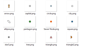
Ever wanted to export your QGIS symbols as images? Yes. Well here is some Python code that will let you do just that:

from PyQt4.QtCore import QSize
from PyQt4.QtGui import QImage, QPainter

style = QgsStyleV2.defaultStyle()
names = style.symbolNames()
size = QSize(64, 64)

for name in names:
    symbol = style.symbol(name)
    if not symbol.type() == QgsSymbolV2.Marker:
        continue

    image = QImage(size, QImage.Format_ARGB32_Premultiplied)
    image.fill(0) 
    painter = QPainter(image)
    symbol.drawPreviewIcon(painter, size)
    painter.end()
    image.save(r"C:\temp\{}.png".format(name), "PNG")

Or in 2.6 it's even easier:

from PyQt4.QtCore import QSize
from PyQt4.QtGui import QImage, QPainter

style = QgsStyleV2.defaultStyle()
names = style.symbolNames()
size = QSize(64, 64)

for name in names:
    symbol = style.symbol(name)
    if not symbol.type() == QgsSymbolV2.Marker:
        continue

    image = symbol.asImage(size)
    image.save(r"C:\temp\{}.png".format(name), "PNG")

Bam!

Alt Text

Why? Because we can.

Exporting QGIS symbols as images

Ever wanted to export your QGIS symbols as images? Yes. Well here is some Python code that will let you do just that:

from PyQt4.QtCore import QSize
from PyQt4.QtGui import QImage, QPainter

style = QgsStyleV2.defaultStyle()
names = style.symbolNames()
size = QSize(64, 64)

for name in names:
    symbol = style.symbol(name)
    if not symbol.type() == QgsSymbolV2.Marker:
        continue
    
    image = QImage(size, QImage.Format_ARGB32_Premultiplied)
    image.fill(0) 
    painter = QPainter(image)
    symbol.drawPreviewIcon(painter, size)
    painter.end()
    image.save(r"C:\temp\{}.png".format(name), "PNG")

Or in 2.6 it's even easier:

from PyQt4.QtCore import QSize
from PyQt4.QtGui import QImage, QPainter

style = QgsStyleV2.defaultStyle()
names = style.symbolNames()
size = QSize(64, 64)

for name in names:
    symbol = style.symbol(name)
    if not symbol.type() == QgsSymbolV2.Marker:
        continue
        
    image = symbol.asImage(size)
    image.save(r"C:\temp\{}.png".format(name), "PNG")

Bam!

symbols.png

Why? Because we can.

QGIS OpenLayers alternative: ArcGIS online basemap

The QGIS Ireland user group posted a method of adding the ArcGIS Online global raster basemap to QGIS to use as an alternative to the openLayers plugin:

http://ieqgis.wordpress.com/2014/08/09/adding-esris-online-world-imagery-dataset-to-qgis/


Slides FOSS4G 2014

Slides from our presentations at FOSS4G 2014 in Portland/Oregon:

@PirminKalberer

Slides FOSS4G 2014

Slides from our presentations at FOSS4G 2014 in Portland/Oregon:

@PirminKalberer

Selective data removal in an elevation map by means of floodfilling

Do you also sometimes get maps which contain zero (0) rather than NULL (no data) in some parts of the map? This can be easily solved with “floodfilling”, even in a GIS.

My original map looks like this (here, Trentino elevation model):

The light blue parts should be no data (NULL) rather than zero (0)...

Now what? In a paint software we would simply use bucket fill but what about GIS data? Well, we can do something similar using “clumping”. It requires a bit of computational time but works perfectly, even for large DEMs, e.g., all Italy at 20m resolution. Using the open source software GRASS GIS 7, we can compute all “clumps” (that are many for a floating point DEM!):

# first we set the computational region to the raster map:
g.region rast=pat_DTM_2008_derived_2m -p
r.clump pat_DTM_2008_derived_2m out=pat_DTM_2008_derived_2m_clump

The resulting clump map produced by r.clump is nicely colorized:

Clumped map derived from DEM (generated with r.clump)

As we can see, the area of interest (province) is now surrounded by three clumps. With a simple map algebra statement (r.mapcalc or GUI calculator) we can create a MASK by assigning these outer boundary clumps to NULL and the other “good” clumps to 1:

r.mapcalc "no_data_mask = if(pat_DTM_2008_derived_2m_clump == 264485050 || \
  pat_DTM_2008_derived_2m_clump == 197926480 || \
  pat_DTM_2008_derived_2m_clump == 3, null(), 1)"

This mask map looks like this:

Mask map from all clumps except for the large outer clumps

We now activate this MASK and generate a copy of the original map into a new map name by using map algebra again (this just keeps the data matched by the MASK). Eventually we remove the MASK and verify the result:

# apply the mask
r.mask no_data_mask
# generate a copy of the DEM, filter on the fly
r.mapcalc "pat_DTM_2008_derived_2m_fixed = pat_DTM_2008_derived_2m"
# assign a nice color table
r.colors pat_DTM_2008_derived_2m_fixed color=srtmplus
# remove the MASK
r.mask -r

And the final DEM is now properly cleaned up in terms of NULL values (no data):

DEM cleaned up for no data

Enjoy.

The post Selective data removal in an elevation map by means of floodfilling appeared first on GFOSS Blog | GRASS GIS Courses.

Share and manage your Data with QGIS Cloud and WFS-T

A lot of people are using QGIS Cloud as a service with ready to use QGIS webclient. It’s very easy to publish data and share maps in this way. But QGIS Cloud has more power under the hood. A not so obvious feature of QGIS Cloud is the option to share your data via Web Feature Service (WFS) and manage them via Web Feature Service Transactional (WFS-T). “The basic Web Feature Service allows querying and retrieval of features. A transactional Web Feature Service (WFS-T) allows creation, deletion, and updating of features” (Wikipedia). With WFS-T you have full access to your vector data for editing over the web. Since QGIS Server includes WFS-T functionality, you can manage and edit your data served by QGIS Cloud from every client supporting WFS-T. In addition, with QGIS Cloud Pro you have the option to control access to your published WFS.

How to setup a QGIS Cloud WFS-T in few steps:

  1. Setup a QGIS Project containing the data you like to pubish as WFS-T

  2. Load local vector data of your choice to your project.

  3. Define vector layers you wish to publish and set the appropriate settings for them in the following way:
    • open the Project Properties -> OWS Server tab.
    • scroll to the WFS-Capabilities section and setup the appropriate settings. Tick Published, Update, Insert and Delete for every layer you want to publish.

  • additionally you can set the published fields of every layer in the Layer Properties -> Fields tab.

  • Publish the project on QGIS Cloud.
    • save the project. (If you don’t have installed the QGIS Cloud plugin, than install it from the official QGIS Plugin Repository)
    • open the QGIS Cloud plugin and log in your QGIS Cloud account. (If you don’t have a QGIS Cloud account, sign up a new account).
    • upload the local data to your QGIS Cloud database (if you don’t have a QGIS Cloud database, create one from the QGIS Cloud plugin).
    • publish the project via QGIS Cloud plugin.
    • that’s it!

Have a look at the Services tab of the QGIS Cloud Plugin. There you will find the URL for Public WMS. Your just created WFS has the same URL. Now you can start working with WFS and WFS-T.

Working with WFS-T in QGIS Desktop

You can access your WFS-T with QGIS or any other client which supports WFS and WFS-T. As an example here we show how to access WFS with QGIS Desktop:

  1. Open the QGIS WFS Server connections dialog (Layer -> Add WFS Layer … ).
  2. Add a new connection
  3. Give the connection a name of your choice and add the above created URL
  4. Click connect and you will see the just published WFS layers
  5. Add one or more of them to your project

Thus you have set the Update, Insert and Delete options for the WFS, these layers can be edited in QGIS like any other editable layer.

All the services published under QGIS Cloud Free are public and accessible by everyone. If you need resctricted access , you can order the QGIS Cloud Pro plan.

Follow @QGISCloud on Twitter for QGISCloud related news and infos.

Share and manage your Data with QGIS Cloud and WFS-T

A lot of people are using QGIS Cloud as a service with ready to use QGIS webclient. It’s very easy to publish data and share maps in this way. But QGIS Cloud has more power under the hood. A not so obvious feature of QGIS Cloud is the option to share your data via Web Feature Service (WFS) and manage them via Web Feature Service Transactional (WFS-T). “The basic Web Feature Service allows querying and retrieval of features. A transactional Web Feature Service (WFS-T) allows creation, deletion, and updating of features” (Wikipedia). With WFS-T you have full access to your vector data for editing over the web. Since QGIS Server includes WFS-T functionality, you can manage and edit your data served by QGIS Cloud from every client supporting WFS-T. In addition, with QGIS Cloud Pro you have the option to control access to your published WFS.

How to setup a QGIS Cloud WFS-T in few steps:

  1. Setup a QGIS Project containing the data you like to pubish as WFS-T
  • Load local vector data of your choice to your project.
  • Define vector layers you wish to publish and set the appropriate settings for them in the following way:
  • open the Project Properties -> OWS Server tab.
  • scroll to the WFS-Capabilities section and setup the appropriate settings. Tick Published, Update, Insert and Delete for every layer you want to publish.

  • additionally you can set the published fields of every layer in the Layer Properties -> Fields tab.

  • Publish the project on QGIS Cloud.
  • save the project. (If you don’t have installed the QGIS Cloud plugin, than install it from the official QGIS Plugin Repository)
  • open the QGIS Cloud plugin and log in your QGIS Cloud account. (If you don’t have a QGIS Cloud account, sign up a new account).
  • upload the local data to your QGIS Cloud database (if you don’t have a QGIS Cloud database, create one from the QGIS Cloud plugin).
  • publish the project via QGIS Cloud plugin.
  • that’s it!

Have a look at the Services tab of the QGIS Cloud Plugin. There you will find the URL for Public WMS. Your just created WFS has the same URL. Now you can start working with WFS and WFS-T.

Working with WFS-T in QGIS Desktop

You can access your WFS-T with QGIS or any other client which supports WFS and WFS-T. As an example here we show how to access WFS with QGIS Desktop:

  1. Open the QGIS WFS Server connections dialog (Layer -> Add WFS Layer … ).
  • Add a new connection
  • Give the connection a name of your choice and add the above created URL
  • Click connect and you will see the just published WFS layers
  • Add one or more of them to your project

Thus you have set the Update, Insert and Delete options for the WFS, these layers can be edited in QGIS like any other editable layer.

All the services published under QGIS Cloud Free are public and accessible by everyone. If you need resctricted access , you can order the QGIS Cloud Pro plan.

Follow @QGISCloud on Twitter for QGISCloud related news and infos.

Exporting QGIS symbols as images

Ever wanted to export your QGIS symbols as images? Yes. Well here is some Python code that will let you do just that:

from PyQt4.QtCore import QSize
from PyQt4.QtGui import QImage, QPainter

style = QgsStyleV2.defaultStyle()
names = style.symbolNames()
size = QSize(64, 64)

for name in names:
    symbol = style.symbol(name)
    if not symbol.type() == QgsSymbolV2.Marker:
        continue

    image = QImage(size, QImage.Format_ARGB32_Premultiplied)
    image.fill(0) 
    painter = QPainter(image)
    symbol.drawPreviewIcon(painter, size)
    painter.end()
    image.save(r"C:temp{}.png".format(name), "PNG")

Or in 2.6 it’s even easier:

from PyQt4.QtCore import QSize
from PyQt4.QtGui import QImage, QPainter

style = QgsStyleV2.defaultStyle()
names = style.symbolNames()
size = QSize(64, 64)

for name in names:
    symbol = style.symbol(name)
    if not symbol.type() == QgsSymbolV2.Marker:
        continue

    image = symbol.asImage(size)
    image.save(r"C:temp{}.png".format(name), "PNG")

Bam!

symbols

Why? Because we can.


Filed under: qgis

Sourcepole at FOSS4G 2014 in Portland

In one week, the 2014 FOSS4G Conference will start in Portland/Oregon. Sourcepole supports this major event as a bronze sponsor.

Our conference contributions:

Workshop presented by Horst Düster (@moazagotl)

  • Tuesday afternoon: QGIS Plugin Development with PyQt4 and PyQGIS

Presentations by Pirmin Kalberer (@PirminKalberer)

  • Thursday, Session 2, Track 7, 13:00 - 13:25: State of QGIS Server
  • Thursday, Session 2, Track 7, 13:30 - 13:55: From Nottingham to PDX: QGIS 2014 roundup
  • Thursday, Session 3, Track 6, 16:25 - 13:25: Easy ETL with OGR

Meet Pirmin and Horst at Sourcepole’s exhibition booth and have a look at our latest products.

We’re looking forward to meet you in Portland next week!

Follow @Sourcepole for selected QGIS news and other Open Source Geospatial related infos.

Scottish QGIS User Group – 21 October, Edinburgh

The next QGIS user group meeting in Scotland is happening on 21st October 2014.
It is being held in the School of Informatics at Edinburgh University.  For more info about the venue: http://www.ed.ac.uk/schools-departments/informatics/about/location

This is your chance to offer a short talk or presentation or workshop so we can build an exciting programme for the day.  The final programme and agenda will be released closer to the date.  Please let me know through the contact form or comments or twitter (@mixedbredie) if you have a presentation or talk you would like to share.

Ross


Sourcepole Kursprogramm Herbst 2014

Im November 2014 bietet Sourcepole wieder sein kompetentes Kursprogramm rund um alle GDI Komponenten an. Zu allen Kursen gehört umfangreiches Kursmaterial, Mittagessen und Kaffepausen. Bei Buchung eines Grundkurses und dem darauf folgenden Aufbaukurs erhalten die Teilnehmer Rabatt auf den Kurspreis.

Geo-Datenbank:

  • PostgreSQL / PostGIS Einführung (3. - 4. November 2014)
  • PostgreSQL / PostGIS für Fortgeschrittene (5. November 2014)

Desktop GIS

  • QGIS 2.4 / Enterprise Desktop Grundkurs (10. - 11. November 2014)
  • QGIS 2.4 / Enterprise Desktop für Power User (12. November 2014)

GDI

  • Verteilte GDI mit der QGIS Suite und PostgreSQL (20. November 2014)

QGIS Programmierung

  • QGIS 2.4 / Enterprise Plugin Entwicklung mit PyQt4 und PyQGIS (17. - 18. November 2014)

Informationen zu den Kursen und die Online Anmeldung finden Sie im Kursprogramm

Wir freuen uns darauf Sie in Zürich begrüssen zu können.

Fundraising for Eloise and Heartfelt

The death of our daughter was one of the hardest things my wife and I have ever had to deal with. It’s not something that I wish anyone ever have to experience and feel really sorry for those who have had to do it many times. There is something really raw about losing your own flesh and blood. It cuts deep, really really deep. There are really no words to describe the emptiness that you feel, or the feelings that follow after the event. Even with all the pain of loosing a child there is a great Australian service that helps to capture some of the final monents. The service is called Heartfelt and we used them for Ellie.

Heartfelt is a great free service that provides a photo session, including editing and prints (hard and digital) after, in the last and final days. This is the quote from their site:

Heartfelt is a volunteer organisation of professional photographers from all over Australia dedicated to giving the gift of photographic memories to families that have experienced stillbirths, premature births, or have children with serious and terminal illnesses.

Heartfelt is dedicated to providing this gift to families in a caring, compassionate manner.

All services are provided free of charge

Pretty impressive stuff. The last thing you want to have to do in a time like that is shell out for photos when you have other pressing issues.

As Ellie’s 1st Birthday is coming in up October Stace and I would love to raise enough money to donate a camera pack to a hospital though Heartfelt in Elly’s name. We have created a fundraiser page in her name at: http://www.mycause.com.au/page/79669/eloises1stbirthdayheartfelt in order collect dontations for anyone who would like to help.

Camera packs can be donated to a hospital to allow staff at the hospital to capture photos if Heartfelt can’t make it. The bonus is that Heartfelt will still edit and print the photos. How bloody awesome is that! More info on the camera packs is at: http://www.mycause.com.au/page/79669/eloises1stbirthdayheartfelt

We would be greatful for any donations, big or small, so we can donate a camera pack in Elly’s name.

We love and miss you a lot Eloise.


Filed under: Open Source

Fundraising for Eloise and Heartfelt

The death of our daughter was one of the hardest things my wife and I have ever had to deal with. It's not something that I wish anyone ever have to experience and feel really sorry for those who have had to do it many times. There is something really raw about losing your own flesh and blood. It cuts deep, really really deep. There are really no words to describe the emptiness that you feel, or the feelings that follow after the event. Even with all the pain of loosing a child there is a great Australian service that helps to capture some of the final monents. The service is called Heartfelt and we used them for Ellie.

Heartfelt is a great free service that provides a photo session, including editing and prints (hard and digital) after, in the last and final days. This is the quote from their site:

Heartfelt is a volunteer organisation of professional photographers from all over Australia dedicated to giving the gift of photographic memories to families that have experienced stillbirths, premature births, or have children with serious and terminal illnesses.

Heartfelt is dedicated to providing this gift to families in a caring, compassionate manner.

All services are provided free of charge

Pretty impressive stuff. The last thing you want to have to do in a time like that is shell out for photos when you have other pressing issues.

As Ellie's 1st Birthday is coming in up October Stace and I would love to raise enough money to donate a camera pack to a hospital though Heartfelt in Elly's name. We have created a fundraiser page in her name at: http://www.mycause.com.au/page/79669/eloises1stbirthdayheartfelt in order collect dontations for anyone who would like to help.

Camera packs can be donated to a hospital to allow staff at the hospital to capture photos if Heartfelt can't make it. The bonus is that Heartfelt will still edit and print the photos. How bloody awesome is that! More info on the camera packs is at: http://www.mycause.com.au/page/79669/eloises1stbirthdayheartfelt

We would be greatful for any donations, big or small, so we can donate a camera pack in Elly's name.

We love and miss you a lot Eloise.

Fundraising for Eloise and Heartfelt

The death of our daughter was one of the hardest things my wife and I have ever had to deal with. It's not something that I wish anyone ever have to experience and feel really sorry for those who have had to do it many times. There is something really raw about lossing your own flesh and blood. It cuts deep, really really deep. There are really no words to describe the emptiness that you feel, or the feelings that follow after the event. Even with all the pain of lossing a child there is a great Australian service that helps to capture some of the final monents. The service is called Heartfelt and we used them for Elly.

Heartfelt is a great free service that provides a photo session, including editing and prints (hard and digital) after, in the last and final days. This is the quote from their site:

Heartfelt is a volunteer organisation of professional photographers from all over Australia dedicated to giving the gift of photographic memories to families that have experienced stillbirths, premature births, or have children with serious and terminal illnesses.

Heartfelt is dedicated to providing this gift to families in a caring, compassionate manner.

All services are provided free of charge

Pretty impressive stuff. The last thing you want to have to do in a time like that is shell out for photos when you have other pressing issues.

As Elly's 1st Birthday is coming in up October Stace and I would love to raise enough money to donate a camera pack to a hospital though Heartfelt in Elly's name. We have created a fundraiser page in her name at: http://www.mycause.com.au/page/79669/eloises1stbirthdayheartfelt in order collect dontations for anyone who would like to help.

Camera packs can be donated to a hospital to allow staff at the hospital to capture photos if Heartfelt can't make it. The bonus is that Heartfelt will still edit and print the photos. How bloody awesome is that! More info on the camera packs is at: http://www.mycause.com.au/page/79669/eloises1stbirthdayheartfelt

We would be greatful for any donations, big or small, so we can donate a camera pack in Elly's name.

We love and miss you a lot Eloise.

Fundraising for Eloise and Heartfelt

The death of our daughter was one of the hardest things my wife and I have ever had to deal with. It's not something that I wish anyone ever have to experience and feel really sorry for those who have had to do it many times. There is something really raw about losing your own flesh and blood. It cuts deep, really really deep. There are really no words to describe the emptiness that you feel, or the feelings that follow after the event. Even with all the pain of loosing a child there is a great Australian service that helps to capture some of the final monents. The service is called Heartfelt and we used them for Ellie.

Heartfelt is a great free service that provides a photo session, including editing and prints (hard and digital) after, in the last and final days. This is the quote from their site:

Heartfelt is a volunteer organisation of professional photographers from all over Australia dedicated to giving the gift of photographic memories to families that have experienced stillbirths, premature births, or have children with serious and terminal illnesses.

Heartfelt is dedicated to providing this gift to families in a caring, compassionate manner.

All services are provided free of charge

Pretty impressive stuff. The last thing you want to have to do in a time like that is shell out for photos when you have other pressing issues.

As Ellie's 1st Birthday is coming in up October Stace and I would love to raise enough money to donate a camera pack to a hospital though Heartfelt in Elly's name. We have created a fundraiser page in her name at: http://www.mycause.com.au/page/79669/eloises1stbirthdayheartfelt in order collect dontations for anyone who would like to help.

Camera packs can be donated to a hospital to allow staff at the hospital to capture photos if Heartfelt can't make it. The bonus is that Heartfelt will still edit and print the photos. How bloody awesome is that! More info on the camera packs is at: http://www.mycause.com.au/page/79669/eloises1stbirthdayheartfelt

We would be greatful for any donations, big or small, so we can donate a camera pack in Elly's name.

We love and miss you a lot Eloise.

5 meter elevation model of Vienna published

A while ago I wrote about the 5 meter elevation model of the city of Vienna. In the meantime the 5 meter model has been replaced by a 10 meter version.

For future reference, I’ve therefore published the 5 meter version on opendataportal.at.

details from the Viennese elevation model

details of the Viennese elevation model

I’ve been using the dataset to compare it to EU-DEM and NASA SRTM for energy estimation:
A. Graser, J. Asamer, M. Dragaschnig: “How to Reduce Range Anxiety? The Impact of Digital Elevation Model Quality on Energy Estimates for Electric Vehicles” (2014).

I hope someone else will find it useful as well because assembling the whole elevation model was quite a challenge.

mosaicking the rasterized WFS responses

mosaicking the rasterized WFS responses


  • <<
  • Page 75 of 142 ( 2821 posts )
  • >>

Back to Top

Sustaining Members