Related Plugins and Tags

QGIS Planet

Eleventh GSoC report – Multithreading on Processing

What do I have completed this week?

  • During this week I have changed the multithreading implementation to use the QThreadPool to allow thread recycling and avoid thread creation costs every time we want to run an algorithm. This new implementation adds some flexibility to the multithread support and avoid unexpected behaviours in different machines. The number of threads in the QThreadPool is initialised accordingly to the number of cores in the PC and may happen that the QT is not able to detect the number of cores. In this case we will only have one thread in the thread pool, which can be occupied with something else. I’m trying to detect when there is no available threads on the ThreadPool and increase the number of threads if necessary.

What am I going to achieve for the next week?

  • Start working on a test suite for the multithreading to ensure the correct behaviour of the multithreading implementation. The test suite must check if the worker thread is starting, check if signals are triggering the functions when it is supposed to and verify if the cancel option is working properly.

  • Figure out how to stop the execution of a non-QGIS algorithm.

Is there any blocking issue?

  • I have spotted some issues when testing the code in a different machine (with Linux Mint 17) that may have to do with thread unavailability.  Therefore, I decided to postpone the current tasks and focus on changing the multithreading implementation in order to correct this kind of unexpected behaviours.

Take part in the QGIS user survey

The QGIS project is asking for user feedback to gain a better understanding of the wishes and requirements of its user base. Please take part in the survey and share the links with other QGIS users. The survey is available in multiple languages:


Take the QGIS User Survey – in Romanian!

Thanks to community member Sorin Călinică, there is now a Romania version of the QGIS User Survey available. We look forward to seeing your responses!


Take the QGIS user survey – in Ukranian!

Thanks to QGIS Community member Alexander Bruy, our Ukranian users can now also participate in the QGIS User Survey in their native language!


Take the QGIS User Survey – in Spanish!

Another great community contribution – you can now participate in the QGIS user survey if you are a Spanish speaker! Thanks to Luigi Pirelli and Victor Olaya for contributing this.


Take the QGIS User Survey – in French!

Another wonderful contribution from the QGIS community, the 2015 QGIS User survey is now available in French! Thanks for René-Luc Dhont for contributing the French translations.


Take the QGIS User Survey in Portuguese!

Thanks to our awesome community, the QGIS User survey is now available in Portuguese! We are looking forward to hearing how the Portuguese speaking community is using QGIS!


Take the QGIS user survey!


Call for applications: QGIS Manual Update and Improvement

Dear QGIS community,

In the last few years we have been steadily improving the amount of funding we are able to accumulate in the QGIS project. Our goal in obtaining funding is always to ‘make QGIS better’. Up until now we have focussed funding on high profile aspects of the project: Funding regular hackfests, paying for bug fixing work prior to releases, funding infrastructure such as servers, domain name registrations etc.

With improved funding levels we now have the opportunity to also start addressing some of the many less obvious components of QGIS that badly need attention, but often don’t attract volunteers. In our PSC meetings it was agreed that we would start this initiative by funding one or more experienced users to improve the QGIS manual. Here, briefly, is the vision:

As an experienced QGIS user you currently have two main resources: The QGIS manual and the QGIS training manual. In this call we focus on the manual, which is already an excellent resource on available functionality in QGIS.

  • The challenge is to keep it synchronised with all new features, and examples and figures often run the risk of being out of date. This is the case already for several chapters of the manual for the latest QGIS releases and we want to start optimizing this.

    We would love to see the QGIS manual providing a readable narrative explaining the purpose (with images and illustrations if needed) of each feature. It can also provide short sample snippet where useful, which in many cases you can simply cut and paste into your code and then tweak to get started.

    For this funded effort we are thus seeking one or more individuals to lay the foundation for this work:

    * verify and improve the norms and guidelines of the documentation and
    especially its update process together with the PSC.
    * update the manual to include all features that are available within the latest QGIS release (2.12).
    * update figures, if necessary according to the defined guidelines (size, desktop-environment, resolution,…).
    * populate the manual with further short examples and improved descriptions, without competing with the training manual.
    * do these in a nice clear and concise writing style, taking inspiration from other software manuals, if available.

    If you think this is something you are able to do, please contact the QGIS PSC using this form and let us know!

    Best wishes,
    Otto


Not always about new features

I love a good feature just as much as the next person but sometimes it’s great to fix a small workflow issue that has bugged you for the longest time.

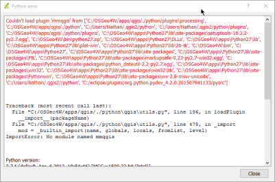
If you have ever seen this kind of dialog you will know what I mean

error

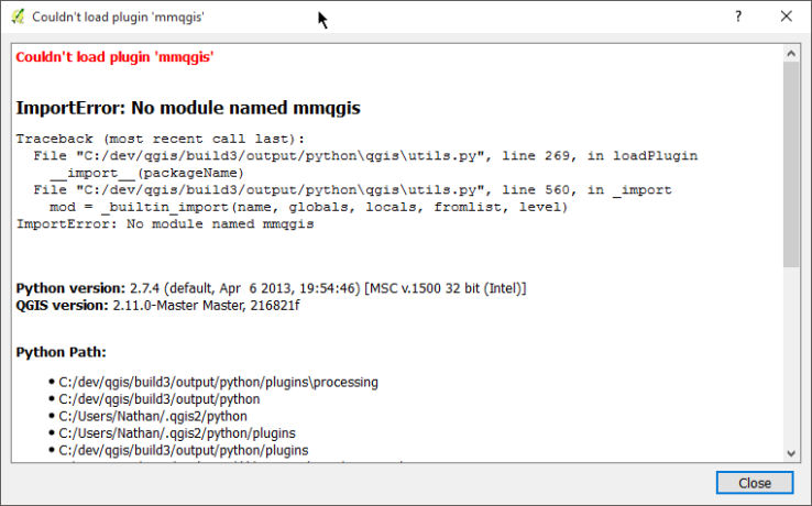
The good old Python error dialog in QGIS.  The dialog is there to tell you that an exception was raised in Python somewhere and would dump out the error for you to debug it.   One big issue with this dialog though.  It’s blocking.  Blocking dialogs are really bad.   As a user, the blocking dialog means a broken workflow. Worst of all, there really is nothing you can do about it because the only thing you can do is close.

This dialog has now been replaced with a message bar if something goes wrong in Python code.  The message bar is non blocking and lets you continue working even if something didn’t work correctly.

message

The message bar has two buttons.  One will open the stack trace dialog to see the error in more detail. The other button opens the log window.

dialog

The message bar will only show a single error message for each type of error even if there are multiple exceptions in a row. A good example of this is an error in a mouse move event handler causing a error on each mouse move.

Quick webmaps with qgis2web

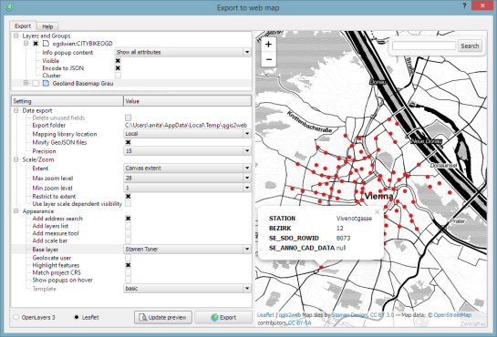
In Publishing interactive web maps using QGIS, I presented two plugins for exporting web maps from QGIS. Today, I want to add an new member to this family: the qgis2web plugin is the successor of qgis-ol3 and combines exports to both OpenLayers3 as well as Leaflet.

The plugin is under active development and currently not all features are supported for both OpenLayers3 and Leaflet, but it’s a very convenient way to kick-off a quick webmapping project.

Here’s an example of an OpenLayers3 preview with enabled popups:

OpenLayers3 preview

OpenLayers3 preview

And here is the same map in Leaflet with the added bonus of a nice address search bar which can be added automatically as well:

Leaflet preview

Leaflet preview

The workflow is really straight forward: select the desired layers and popup settings, pick some appearance extras, and then don’t forget to hit the Update preview button otherwise you might be wondering why nothing happens ;)

I’ll continue testing these plugins and am looking forward to seeing what features the future will bring.


Feature freeze is now in effect for QGIS 2.12

A note from Jürgen Fischer, our release manager, heralds the start of preparations for QGIS 2.12. We depend all users out there to test it and report issues so we can make the best possible release. An edit version of the email to the developer mailing list from Jürgen follows:

Hi,

I’d like to remind everyone that the 2.11 development cycle ended yesterday at
12:00 UTC. We are now in feature freeze on the road to the 2.12 release on 2015-10-23

Now we (the community) need to prepare QGIS for the release. No new features will be added anymore.

  • Users, if not already begun, should now start
    extensive testing of master and report bugs on the QGIS hub.
  • Developers should move their focus from creating new features to fixing bugs.
  • Translators can can continue their work (we maintain all our translations on transifex now).

The nightly builds of QGIS testing available for Windows (download here), Linux (Debian and Ubuntu) and Mac
OS X (download here) are now effectively snapshots of what’s going to be released.  Except of course
for the bugs that are going to be fixed until release day.  For Windows there will also be weekly release candidates of the standalone installer. Lets keep up working together to make 2.12 another great release.

Jürgen


What went on at FOSS4G 2015?

Granted, I could only follow FOSS4G 2015 remotely on social media but what I saw was quite impressive and will keep me busy exploring for quite a while. Here’s my personal pick of this year’s highlights which I’d like to share with you:

QGIS

Marco Hugentobler at FOSS4G 2015 (Photo by Jody Garnett)

Marco Hugentobler at FOSS4G 2015 (Photo by Jody Garnett)

The Sourcepole team has been particularly busy with four presentations which you can find on their blog.

Marco Hugentobler’s keynote is just great, summing up the history of the QGIS project and discussing success factor for open source projects.

Marco also gave a second presentation on new QGIS features for power users, including live layer effects, new geometry support (curves!), and geometry checker.

There has also been an update to QTiles plugin by NextGIS this week.

If you’re a bit more into webmapping, Victor Olaya presented the Web App Builder he’s been developing at Boundless. Web App Builder should appear in the official plugin repo soon.

Preview of Web App Builder from Victors presentation

Preview of Web App Builder from Victors presentation

Geocoding

If you work with messy, real-world data, you’ve most certainly been fighting with geocoding services, trying to make the best of a bunch of address lists. The Python Geocoder library promises to make dealing with geocoding services such as Google, Bing, OSM & many easier than ever before.

Let me know if you tried it.

Mobmap Visualizations

Mobmap – or more specifically Mobmap2 – is an extension for Chrome which offers visualization and analysis capabilities for trajectory data. I haven’t tried it yet but their presentation certainly looks very interesting:


Presentations at FOSS4G 2015 in Seoul

Slides from our presentations at FOSS4G 2015 in Seoul:

  • Keynote: The QGIS project and its evolution from a desktop GIS to a GIS platform - Slides
  • New QGIS functions for power users - Slides
  • QGIS Plugins - From Must-Haves to insider tips - Slides
  • Building an OpenLayers 3 map viewer with React - Slides

Thanks to the organizers of this great conference! It was a pleasure to get in contact with so many users from around the world.

foss4g2015

FOSS4G specials at Packt and Locate Press

We are celebrating FOSS4G 2015 in Seoul with great open source GIS book discounts at both Packt and Locate Press. So if you don’t have a copy of “Learning QGIS”, “The PyQGIS Programmer’s Guide”, or “Geospatial Power Tools” yet, check out the following sites:

2


4th QGIS UK user group meeting in Edinburgh

4th QGIS UK user group EdinburghOK. Here it is. The official call for offers of speaking, running a workshop, doing a lightning talk, generally helping, and sponsoring the 4th QGIS UK user group meeting in Scotland on 16th November. Tom Armitage has booked the Informatics Forum in Crichton Street for us again.

Tickets are available here: http://www.eventbrite.com/e/uk-qgis-user-group-scotland-tickets-19194628651

I am open to suggestions from you, the users, about how the day is organised but I imagine something that has a few talks, a workshop session and a good lunch break would tick most boxes.  So get in touch and let’s make it happen.

Use the contact form on the About Us page to get in touch or via twitter @mixedbredie.

UPDATE: 4th-Scottish-QGIS-user-group-meeting agenda now available.

Sponsored by OS thinkWhere EDINA

Registration open for QGIS hackfest in Gran Canaria, November 2015

Dear QGIS developers

Collage Las Palmas de Gran Canaria

We will be holding our 14th hackfest in Gran Canaria over November 5th – November 8th, 2015. You can read more about the plans for this meet up and register your intention to attend on the hackfest wikipage. This is a developer centric hackfest where we invite coders, documenters, testers, graphic artists, translators and anyone else who is interested in improving QGIS for the benefit of all our users. General users of QGIS are of course also welcome to join us, but we will not be holding any specific user-centric workshops or talks like we do at our user conferences.

The QGIS hackfests are an important aspect of the project, playing an key role in facilitating collaboration and planning within the community of developers and contributors who combine their efforts to put out three releases of QGIS each year. We rely on the goodwill and sponsorship of our grateful users and their host organisations to financially sustain the QGIS project. If you are in a position of influence, we ask you to please consider sponsoring QGIS to support this hackfest and other project related activities.

We would like to thank Pablo Fernández Moniz and his co-organisers from Universidad de las Palmas de Gran Canaria for organising the event. If you are able to support his event organisation activities in any way, please contact him at 

We look forward to seeing your all there!

The QGIS Team


UI theme support now core in QGIS

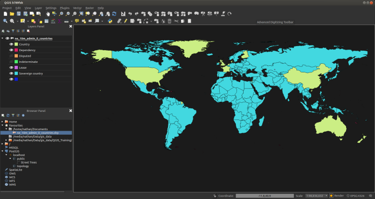
I enjoy using the dark UI theme for QGIS so much I figured why not make it a core feature. In the next version of QGIS if you head to the options screen you can now find a UI Theme option.

Options | General_037

The default dark theme is called Night Mapping for all those late night mapping jobs that you do, or if you just like dark UI themes.

QGIS b789fab_029

Selection_031

Selection_034

Something you will notice with this theme is the custom icons for the layer visibility. Pretty nifty! Here is how it is done

Creating new themes

To create a new theme simply make a new folder in .qgis2\themes\ with the name of the theme you want and create a style.qss file inside there. Check out the default themes for an example

Follow the Qt style sheet guides to see what can be styled.

Something I have added on top of the normal style sheets is variable support. Variables can be declared in a variables.qss file in the theme folder.

Here is an example of some variables:

@background: #323232
@text: #aaa
@selection: #507098
@menuback: #444
@highlight: #ffaa00

Now in style.qss we can do this:

QWidget
{
color: @text;
background-color: @background;
}

Great for not having to repeat your self or quick updating in a single place. When the theme is applied via the Options dialog or via the API it will replace the variables in style.qss using variables.qss. The result file is called style.qss.auto

Needs some tweaks

The default dark theme is a collection of stuff I have found around the net and stuff I have added myself. It’s far from prefect and I would love help to make it the best dark theme for QGIS. If you have another theme you think would make a good default one open a pull request on GitHub

Enjoy

Final GSoC report

What do I have completed this week?

  • Added a dedicated threadPool for the Processing Toolbox to run the algorithms.

  • Bugfix on the cancel option. Avoid connecting  the signals every time the algorithm runs. This was making the slots to be called multiple times when running and cancelling the algorithm several times.

Is there any blocking issue?

  • I wasn’t able to fix the issue with the cancel option when you have more than one algorithm running. The issue turned out to be more complicated than I first expected.

Mixing a bit of Excel into QGIS – conditional formatted table cells

I was using Excel the other day and used the conditional formatting rules to style some cells based on a condition. If you have never seen or used them they look like this:

They are pretty handy for a quick idea on the state of your data.  Looking at QGIS I thought to myself “Wait!? Why not do that in QGIS too. That would be pretty neat”.  And with that here it is, finally!. Conditional formatting rules for QGIS attribute table.

cells

icons

You can control the font style, color, background color, even custom icons based on QGIS symbols. The buttons at the top give you access to quick styles which you can tweak more with the other options.

The conditions are just normal QGIS expressions. Use the special variable @value to refer to the current cell value. As they are normal QGIS expressions you can reference the other fields in the expressions.

(Click the GIF for a better view)

table

So go nuts. I would love to hear any feedback if you use it. Try it out in the next nightly dev build.


Filed under: Open Source

  • <<
  • Page 64 of 141 ( 2820 posts )
  • >>

Back to Top

Sustaining Members