Thanks to the tireless efforts and incredible generosity of the QGIS user community, our crowdfunded QGIS Layout and Reporting Engine campaign was a tremendous success! We’ve reached the funding goal for this project, and as a result QGIS 3.0 will include a more powerful print composer with a reworked code base. You can read more about what we have planned at the campaign page.
We’d like to take this opportunity to extend our heartfelt thanks to all the backers who have pledged to support this project:
The Swiss QGIS User group (funded preliminary work in refactoring how compositions are handled and stored within projects)
The QGIS Grant Program (2016) (funded preliminary work allowing for a flexible property framework which will be used within the project)
We’ve also received numerous anonymous contributions in addition to these – please know that the QGIS community extends their gratitude for your contributions too! This campaign was also successful thanks to The Agency for Data Supply and Efficiency, Denmark, who stepped up and have funded an initial component of this project directly.
We’d also like to thank every member of the QGIS community who assisted with promoting this campaign and bringing it to the attention of these backers. Without your efforts we would not have been able to reach these backers and the campaign would not have been successful.
We’ll be posting more updates as this work progresses. Stay tuned…
QGIS Developers and Community Members working on QGIS at our recent meet up in Essen, German,
Dear Voting members (and interested QGIS community members out there)
This is an open letter that was emailed to all QGIS voting members today
Just a quick note from me to thank you for participating in our ‘virtual AGM’ – I know it is a bit of an unusual system but it suits our geographically diverse nature well and we seem to have pretty good participation in the process (though I really encourage those voting members who did not participate to do so next time!).
I have done a bunch of updates on our governance section of the web site so you can find the AGM minutes, annual report, budget etc. all on the site, and I (or whoever is chair) will post them there in future years too so everything is in one place and easy to access. Here with the relevant links:
Thank you all for the many useful hints, tips and suggestions I regularly receive on how to make things smoother within the project (keep them coming!) – hopefully we will get into a steady routine with this governance now. We have been going through a lot of ramp up trying to get templates, processes, etc in place as we switch over to QGIS.ORG legal entity etc. We appreciate your patience while we figure things out – and a very big thank you to Andreas Neumann and Anita Graser who have pitched in with a lot of administrative work behind the scenes to help get the QGIS legal entity in place!
What’s next? I will be starting the nomination process for 4 new community voting members, soon (one to match each of the incoming country user groups for Norway, Sweden, South Africa and France). At the end of that process we will have 31 voting members.
Soon QGIS.ORG will be in the Swiss Trade Registry, which means we can be VAT registered, can take ownership of the QGIS.ORG trademark (which is currently held in proxy for us) and of course present ourselves as a well governed project, hopefully attractive to large funders who recognize the global good a project like QGIS does!
We are going back to Nødebo! Each year we combine one of our QGIS Developer Meetings with a User Conference. The User Conference is a great opportunity for QGIS users to meet developers and share their experiences – both with developers and with other users. Our first ever User Conference was held in Nødebo, Denmark in 2015 and we are thrilled to be going back to the beautiful venue at the University of Denmark’s Forest and Landscape College.
The user conference will be combined with the QGIS Developer Meeting and a summer school event, with the first week being focussed on the User Conference, the intermediate weekend on the QGIS Hackfest and the second week on the Summer School. The event will run from the 2nd of August through to the 11th of August 2017.
We would like to invite those who are interested in presenting a talk to apply now (NOTE: Deadline for proposals is May 15 2017). There are four kinds of contributions you can make (see the conference website for full details):
20 minute ‘lightning’ talks
1-2 hour short workshops
half and full day workshops
posters (which should be presented in the form of a map)
We have identified a number of themes for the User Conference:
QGIS Software Development
New Technology
Business
Government/Municipality
Science
Education
Presenters of full day workshops are eligible for a EUR 1000 reimbursement to offset their costs. You can find out more details at the conference web page (as well as registering your talk / presentation):
We are extremely pleased to announce the winning proposals for our 2017 QGIS.ORG grant programme. Funding for the programme was sourced by you, our project donors and sponsors! Note: For more context surrounding our grant programme, please see:
Our intent with the QGIS.ORG Grant Programme is to support work from community that would typically not be funded by client/contractor agreements, and that contributes to the broadest possible swathe of our community by providing cross-cutting, foundational improvements to the QGIS Project.
Voting to select the successful projects was carried out by our QGIS Voting Membership. Each voting member was allowed to select up to 6 of the 13 submitted proposals by means of a ranked selection form. The full list of votes are available here (on the first sheet). The second sheet contains the calculations used to determine the winner (for full transparency). The table below summarizes the voting tallies for the proposals:
A couple of extra notes about the voting process:
The PSC has an ongoing program to fund documentation so elected to fund the processing documentation work separately from the grant programme (note *1).
Voting was carried out based on the technical merits of the proposals and the competency of the applicants to execute on these proposals.
No restrictions were in place in terms of how many proposals could be submitted per person / organization, or how many proposals could be awarded to each proposing person / organization.
Because of the importance of having good packaging systems on each of the three major platforms, the PSC elected to additionally fund the work on MacOS bundling scripts (note *2).
Although the budget for the grant programme was €20,000.00, the total amount for the four winning proposals is €19,800.00, with an additional €5, 800.00 being made available to support the processing work and and MacOS packaging work.
Voting was ‘blind’ (voters could not see the existing votes that had been placed).
We had great participation in the voting process. Of the 27 voting members, 23 registered their votes.
On behalf of the QGIS.ORG project, I would really like to thank everyone who submitted proposals for this call. There were many interesting proposals that I believe would be of great benefit to QGIS and I hope others perusing the proposals list will use their initiative and funding interesting proposals independently if they can.
Below you can find the detailed proposals of the successful applications – we look forward to seeing the results of their work land in the code base soon!
Details of the approved grant proposals
9 ADD CONSISTENCY TO UI CONTROLS
Proposer: Nyall Dawson
Amount: €1800
Details: Across the QGIS UI, numerous inconsistencies exist in the way different properties like opacity and rotation are exposed to users. These inconsistencies make QGIS harder to use, as behavior from one dialog differs to the behavior in another dialog. Some examples of this include:
Rotation of labels is done in the opposite direction in labeling to symbology. Accordingly, an equal rotation value will result in different rotation between labels and symbols.
Scales are inconsistently presented, with use of both the scale numerator and denominator in different dialogs. “Minimum” and “Maximum” scales also vary between dialogs, with some dialogs using “minimum” scale as the largest scale and some using “minimum” as the smallest scale. The labeling scale based visibility controls are the biggest offenders here.
Controls vary between specifying “opacity”, “transparency” and “alpha”. While these all have similar results, users must adopt values to map “opacity” to “transparency” in different dialogs. This is further compounded by different ranges used for each (eg 0-100%, or 0-255).
Due to the usual API freeze, it has not been possible to fix these discrepancies. The current API break introduced with version 3.0 allow a window for addressing these issues and standardizing behavior and API.
Despite the benefits in providing a consistent UI, the work involved in standardizing is fiddly (careful attention must be paid to not breaking existing projects) and repetitive, and unlikely to be undertaken by developers on a volunteer basis. Furthermore it is highly unlikely that a commercial organisation could justify sponsoring UI standardisation efforts. Without grant funding it is unlikely that these issues will be addressed during the 3.0 development cycle, and the inconsistencies would remain for the lifetime of QGIS 3.x.
In this proposal I will:
convert all “transparency” controls to “opacity” controls, and consult with the community to determine the ideal value range presented (0-100% or 0-255) before making all opacity controls use the same range.
Ensure that rotation always operates in the same direction.
Fix the labeling scale ranges to use the same scale range definitions as layer visibility
As much as possible, automatically upgrade existing projects so that they open in QGIS 3.0 without any loss of transparency/rotation/scale settings
(As much as possible without large refactoring), adapt the PyQGIS API so for consistent naming and use of opacity/rotation and scale setting/getting methods. Making the API consistent makes scripting QGIS and writing plugins easier.
History: No work has currently been undertaken in this regard.
Qualifications: I am currently one of the most active QGIS developers, with a long history of quality contributions to the project. I’m passionate about seeing QGIS 3.0 address these kinds of long standing UI issues which detract from QGIS’ otherwise professional image and ease of use.
Implementation Plan: The work will be undertaken prior to the QGIS 3.0 feature freeze period.
Proposal Link:
3 EXTEND UNIT TEST COVERAGE FOR GEOMETRY CLASSES
Proposer: Nyall Dawson
Amount: €2000
Details: Since QGIS 2.8, there has been an increased focused on creation of quality automated regression (“unit”) tests designed to flag issues in code before the code is introduced to the QGIS codebase. The increase in stability of recent QGIS versions can be directly attributed to this growth in unit testing. Despite this, many areas of the QGIS codebase remain with little or no unit test coverage.
One critical area which has insufficient unit tests is the geometry classes. The geometry classes form the basis of all geometry interpretation, algorithms, and rendering within QGIS. In order to provide stable QGIS releases, it is crucial that these fundamental classes are rock-solid, efficient, and do not suffer regressions between releases.
Some years ago (shortly after the introduction of the new geometry engine, in which support for Z/M values and curved geometries was added) I added full test coverage for the Point and Linestring classes, and partial coverage for the Polygon class. Unfortunately, writing geometry tests is tricky and time consuming. There’s many corner cases with unusual or invalid geometries which need to be tested. The time commitment required prevented me from writing additional tests, and to date the remaining classes (including multi geometries and all curved geometry types) have little or no test coverage.
This proposal covers writing additional unit tests to cover all the remaining geometry classes.
It is important to note that unit tests do NOT ensure bug free software. Unit tests only protect existing logic and avoid regressions when the covered parts of the code base are changed in future releases. Despite this disclaimer, the process of creating unit tests usually stress-tests existing code and in itself CAN reveal existing bugs. This was certainly the case when the existing tests for Point and Linestring classes were added – creation of the tests alone resulted in many fixed bugs and stabler Point and Linestring geometry handling.
History: This work would continue on from work I begun a number of years ago to provide 100% unit test coverage for the base geometry classes.
Qualifications: I have a long history of quality contributions to the QGIS project, and am currently one of the most prolific committers to the QGIS codebase. I have a long history with adding unit tests to QGIS and advocating for their increased usage amongst developers.
Implementation Plan: This work would be targeted to the QGIS 3.0 release, and would be committed to the codebase prior to the feature freeze/bug fixing period leading up to the 3.0 release.
Proposal Link:
8 QGIS 3D
Proposer: Martin Dobias
Amount: €10000
Details: I would like to propose a project that introduces 3D rendering capabilities in QGIS. To summarize the planned work, the following features can be expected:
2D view of map canvas rendered on the graphics hardware (GPU) allowing smooth zooming and panning of map view
3D perspective view of the map
generation of 3D terrain model from DEM (digital elevation model) layers
map layers rendered as a texture on top of the 3D terrain
support for true 3D rendering of vector layers rather than having just flat appearance
map view widget that is dockable in the main window and synchronized with the main map canvas
support for picking (identification) of objects in 3D view and X/Y/Z coordinate display
support for 3D map view in map composer
The overall target is to introduce an extensible framework for 3D map view within QGIS, so that in the future developers can add various 3D rendering techniques for map data, using custom geometries and materials (which may involve writing own vertex/fragment shaders), possibly even allowing multi-pass rendering for advanced effects (e.g. to render shadows cast by buildings with a particular sun position). 3D support in QGIS is not only about adding the extra dimension to the rendering: it is also about making it possible to use graphics hardware for rendering of map in 2D – making map browsing even more pleasant and faster at the same time. Rendering 2D maps with OpenGL also opens the door to various new graphical effects that would be otherwise very expensive
to achieve by using just CPU for map rendering. This proposal does not assume addition of new geometry types like polyhedral surface (with read support for those) into QGIS – the aim of the work is to get 3D rendering engine running and new geometry types may be added at some point later.
State of the art
QGIS features very good 2D rendering capabilities, however its 3D support has been very limited. Prior work on 3D in QGIS includes:
Globe plugin – a C++ plugin developed by Matthias Kuhn and Sourcepole based on OpenSceneGraph and osgEarth libraries. OpenSceneGraph is a generic toolkit that provides higher-level abstraction on top of OpenGL, making it easier to develop 3D applications than directly using low-level OpenGL interfaces.OsgEarth project then builds on top of OpenSceneGraph and provides a toolkit for working with geographical data: it has a terrain engine that combines elevation layers into a terrain, applies textures from “image” layers and adds feature layers with true 3D objects.The plugin acts as a bridge from QGIS environment and feeds scene data into osgEarth to do the 3D rendering.
Qgis2threejs plugin – a Python plugin developed by Minoru Akagi. It is able to export QGIS project (with various configuration options) into a HTML page that uses three.js library to render map in 3D within web browser using WebGL.
Horao – developed by Oslandia. It is a standalone 3D viewer based on OpenSceneGraph that may be controlled by a QGIS plugin to display map from QGIS in 3D environment. It has explicit support for true 3D geometries in PostGIS.
While these projects solve some use cases for 3D rendering of map data, each of them have their own limitations. For example, osgEarth library used by Globe plugin has its own data access and rendering of vector features implementation, duplicating QGIS code and not having parity in their capabilities. Moreover it has been difficult over time to keep the build working on all platforms supported by QGIS. The main limitation of Qgis2threejs plugin is the fact that the 3D view is exported to web browser, so the user cannot use benefits of having 3D view tightly integrated with the rest of QGIS. The fact that Horao has a standalone viewer
application results in similar limitations as when using Qgis2threejs (although it has some degree of integration with QGIS application).
Proposed approach Now that QGIS 3.0 is based on Qt5, we can use some of the great new functionality added recent releases of Qt5. In version 5.5, a new framework for working 3D graphics has been introduced and every major Qt5 release since has been adding more functionality, improving performance, compatibility and stability. The 3D support nicely integrates with the rest of the Qt framework, providing a familiar API and at the same time staying very generic and highly efficient. The 3D framework provides high level abstractions just like other libraries (e.g. OpenSceneGraph, three.js). 3D scene is built with nodes (called entities) with various components (e.g. transformation, mesh, material). The idea is to build 3D support in QGIS on top of the Qt 3D framework. From my initial tests of the framework this looks feasible and it will allow us to stick with Qt APIs without requiring extra dependencies. The work can be divided into the following chunks of work:
Rendering engine core: develop a framework that will do rendering of the map scene in 3D. The engine will have the responsibility of processing raster layers with elevation into a mesh geometry and texturing the mesh with map images rendered by the existing QGIS 2D rendering engine. The engine will support levels of detail (LOD) and tiling in order to be able to display high-resolution data in real time without having to load all the data into memory at the time of scene creation (which may be prohibitively expensive with more complex layers). 3D scene will be dynamically updated as user browses the map, keeping the amount of rendered triangles low while appropriate quality of the terrain for given zoom level.
All of the processing needs to be done in the background, so the user may freely browse the map and the scene will be continuously updated with data (changing between higher/lower detail when zooming, loading more data when moving map).
Handling of user input: controller for camera that will make the camera fly on top of the map. Support for picking will be added to allow identification of objects in the map and display of coordinates at the mouse position.
Integration with QGIS environment: dockable 3D map widget for the main window, synchronization with 2D map canvas, support for printing of 3D views in map compositions.
Advanced 3D rendering techniques: interface that will allow adding new methods for data visualization in 3D and exploration of methods for rendering. By default map layers will be rendered into map image with the existing 2D map renderer – this interface will allow map layers to instead have 3D renderer associated which will provide entities with custom meshes and materials. As a result we will be able to achieve true 3D appearance of objects (e.g. point clouds, trees as 3D models, tesselation of polygons, buildings with extruded geometry and custom texture). Implementation of the advanced techniques is a task with nearly unlimited scope, so the idea is to develop a suitable interface and as the time will allow, implement some techniques.
History: For this proposal I have studied various sources:
looked into existing 3D viewer projects related to QGIS
explored Qt 3D framework
researched some academic papers regarding terrain generation and vector data display
As a proof of concept, I have created a simple prototype in C++ using Qt 3D framework. It displays aerial imagery on top of a terrain model created from a raster layer (DEM) and allows simple camera control. The code is available here: https://github.com/wonder-sk/qgis3d
Qualifications: I have been a core QGIS developer for more than 10 years and I have a very good knowledge of QGIS codebase, especially the existing 2D map rendering pipeline. Previously when working at the university, on a project for stereo matching (creation of point cloud out of a pair of images) I worked on visualization of 3D data using OpenGL. Implementation Plan: The plan is to work on the project between May and July 2017. As of now, the plan for QGIS releases (according to the mail from Paolo) is that QGIS 3.0 will have feature freeze in July 2017 and final release in September 2017. If nothing changes in the QGIS release schedule in meanwhile, the 3D support could be integrated into QGIS master branch before the feature freeze and thus released in QGIS 3.0. If the project would be accepted, the first step will be to develop a prototype of the 3D rendering engine, then prepare a more detailed architecture proposal as a QEP and continue the implementation once the QEP gets accepted by the community. The work progress should be available on a branch in GitHub for anyone interested. Proposal Link:https://github.com/wonder-sk/qgis3d
6 PROCESSING ALGORITHM DOCUMENTATION
Proposers: Matteo Ghetta, Alexander Bruy
Amount: €4000
Details: This proposal aims to improve the existing Processing algorithms documentation. With the pull request https://github.com/qgis/QGIS/pull/3911 it is possible to add external links for the documentation (both local and remotes). However the effective use of the pull request is not yet included in Processing.
With this proposal the existing code will be incorporated in Processing, allowing to have a Short Help tab (the existing one on the right of the Processing algorithm window) and a Long Help tab (next to the Log tab).
The default link of the on-line documentation will be added in the QGIS Settings (thanks to the pull request already merged) in order to have the standard documentation visible but to let the user the choice to overwrite it and load custom paths.
In addition to the code part, this proposal aims also to document the GDAL/OGR provider and the QGIS core algorithms. Existing documentation will be reviewed and pictures will be added when useful, while for algorithm not yet documented, the help will be written from scratch with description and additional pictures.
Currently there are:
49 GDAL/OGR total algorithms, 35 to enhance with pictures, 14 to write from scratch
154 QGIS algorithms, 38 to enhance, 116 to write from scratch
This means a total of 73 algorithm to enhance and 130 to write from scratch.
History: The pull request https://github.com/qgis/QGIS/pull/3911 is already merged and it is worth to make it effective to have nice, rich and translatable documentation for the Processing algorithms.
Qualifications: Matteo Ghetta: working since the release 2.0 on the documentation and made several improvements and pull request to both documentation and Processing code.
Alexander Bruy: core developer since 2010, co-maintainer of the QGIS Processing framework.
Implementation Plan: The code and the documentation will be ready for the QGIS 3 release.
Proposal Link:
5 IMPROVE DEEP RELATIONS WITH POSTGRES EDITING
Proposer: Régis Haubourg
Amount: €6000
Details: QGIS has reached a mature level and offers now a very good framework to create professional applications. One of the main reasons is that QGIS is a very strong client for spatial databases, and in particular with PostgreSQL and postGIS for which it was initially created.
Since version 2.14, QGIS offers the not-so-well-known ability to handle transaction groups, which means it can instantly evaluate triggers on database side, and refresh all layers in the same transaction. This is a big win for usability, but some drawbacks glitches remain, such as the lack of the undo/redo edit buffer, a very raw way of saving (ie quitting edition session) or having the legend cluttered by so many edit symbols (a pen symbol). Current proposal is to go a step beyond to make QGIS even better for PostgreSQL by achieving the following targets:
1 Restore an undo /redo feature by taking advantage of PostgreSQL. If possible we will try to take advantage of PostgreSQL named Savepoints.
2 Allow to have some layers not switching to edit mode in QGIS, even if they belong to the same connection. These layers will still benefit from the instant refresh, but won’t clutter the legend with the edit pen symbol everywhere, nor risk to load QGIS snapping cache for nothing. A UI for those settings could be an evolution of the current “identify layer” list in the project properties.
3 We would like to submit a mechanism to allow converting error messages raised by the provider, like a RAISE from postgres, into custom user oriented message. Say for instance, instead of a “provider error – duplicate key for… “, QGIS project could be tuned to display first “You tried to insert a feature using the same identifier as another one”.
The error message list and regexp rules would be optionally stored in qgis project or read from a datasource table (for instance when error messages rewrites are shared by other applications). The original error message would be still avaiblable by expanding the details of the messageBar and in the general message log.
4 Cherry on cake point, we wish to have QGIS take advantage of PostgreSQL NOTIFY signals to trigger behavior in QGIS when something changes in the database (see https://www.postgresql.org/docs/9.5/static/sql-notify.html) . A first implementation proposal is to allow a map canvas refresh, but we can imagine really dynamic applications driven by the database events by converting NOTIFY messages into QGIS signals (oh yeah!).
History: In our team, we already use transaction groups for production tools and that is much appreciated. We already use some python logic to catch error message and convert them to more user oriented ones. We frequently develop applications where QGIS is linked with heavy database containing most of the intelligence. Having a really interactive edition process, speaking the same langage as average users, and being able to be triggered from database process will unleashed many possible applications.
Qualifications: Oslandia has three QGIS developers, two of them being core comiters and high skills with Postgres and Postgis (core comiter too). We believe that developing using thick databases is a major strength of QGIS, and we have great fun getting involved in that area of the code
Implementation Plan: We currently are quite involved in QGIS 3 server refactoring and major changes such as Auxiliary Storage for project or core solutions for label connectors. We also are involved in applications build on top of QGIS for Water management like QWAT or QGEP. Such changes would benefit immediatly to those project. Our target is to provide those improvements with all necessary unit tests for 3.0 release.
Proposal Link: coming soon..
13 UPDATE MACOS CMAKE BUNDLING SCRIPTS
Proposer: Larry Shaffer
Amount: €1800
Details: Currently, the macOS bundling routines (to create a self-contained QGIS.app application) in CMake scripts where created by William Kyngsburye many years ago. Since then, CMake has added many features for bundling, e.g. BundleUtilities ( https://cmake.org/cmake/help/v3.0/module/BundleUtilities.html), that handle similar functionality to what has been arduously maintained in the CMake scripts. While the current setup does function, it is quite antiquated and adding any new QGIS dependencies to be bundled is an error-prone ordeal. I propose to fully update the bundling routines to leverage modern CMake capabilities, since building on macOS usually uses the latest CMake versions. Once completed, anyone with appropriate dependencies should be able to produce a production-ready QGIS.app bundle, including the QGIS project itself.
History: I will first build upon the existing work to ensure there is a minimal bundled QGIS.app, then completely refactor the same functionality using a modern CMake code workflow.
Qualifications: I have extensive knowledge in CMake and frequently utilize it in my work for my employer, Boundless Spatial. I have already completed a fully bundled QGIS.app distribution by my employer (similar to the first phase of the proposed work here), though Boundless now uses a different installation approach. I have been working for years on the OSGeo4Mac project in anticipation of producing better CMake bundling routines, to ensure the QGIS project can independently produce its own macOS distributions.
Implementation Plan: Basic work will follow these steps:
Append minimal bundling to existing CMake setup, so there is a least a functioning bundling routine, regardless of whether the proposed work is accomplished in time for the major next release.
Ensure the QGIS.app bundle is code-signed
Create a new methodology, based upon CMake’s BundlesUtilities, *in-line* next to the existing CMake routines, so both can be used, until there is a valid replacement.
Focus on minimal bundling, then add GRASS
Continue extending bundling routines to include major Processing providers, e.g. OTB, Saga, TauDEM, etc.
Ensure new method’s QGIS.app is properly code-signed
Enable bundling on Travis CI infrastructure, via Travis’ cron jobs, thereby adding the capability for the QGIS project to produce fully bundled nightlies of macOS builds.
Once new method represents a full replacement, old method will be removed, not just deprecated
Intended completion is in time for QGIS 3.0 release and packaging efforts.
Since the new method does not affect any existing code, as soon as useable functionality is achieved, it will be merged directly into master, then further code committed as work progresses.
Proposal Link: None at this time. Should I consider a QEP? Not many developers beyond the few existing packagers and experimenters would be involved. I would prefer to write a blog post after the work is completed, though post to the QGIS dev mailing list the intention to do the work, if this proposal is granted.
In February this year, we put out a call for applications for the second (yay!) round of the QGIS grant programme. The intent of the programme is to leverage donor and sponsor funding in order to support community members with great ideas to improve the underlying infrastructure of the QGIS project and code base.
We have had a really great response to the call for applications (detailed list of applications is here for your reading pleasure – 231KB download).
Given that we have 13 proposals (down 7 from our last call) and only 20,000 Euros to disburse, the QGIS voting members will need to make some tough, pragmatic choices.The voting for the grant proposals ends at the mid April 2017, and we plan to announce the successful candidates soon after that. The PSC will arbitrate in the case of a dead heat or the proposal amounts of the top voted proposals not adding up to our funding target.
Although the number of proposals submitted is down from last year, the quality and utility of the proposals this year is really top notch and it is sad to know that we will not be able to fun them all through the grant programme. If you have the wherewithal to further support some of the grant proposals that did not make the cut, or the QGIS 3.0 effort in general, please get into contact with our treasurer, Andreas Neumann (finance [at] qgis.org) or head over to our sponsorship or donations page to support their work!
Lastly, I appeal to those QGIS Voting Members who have not yet cast their votes to check your email and head over to the voting form to cast your vote!
That is a questions my students often ask. Open Source is a strange and new ‘world’ for most of them. So I try to explain: QGIS is a software, developed and maintained from all over the world by developers who are employed by companies, self-employed or working for free…
Some of the work is paid for by QGIS and some by users and as written – some do it for free – yay! The core developers meet two times a year for ‘Hackfests’ (do not confuse with ‘Hacking’).
Sometimes a Hackfest is combined with a user conference – where developers and users can meet, listen to presentations and discuss functionality.
In 2017, the first Hackfest will take place at the Linuxhotel in Essen – Germany from Friday from 28th April – 1st May. This Hackfest is only going to be hard work for the developers – QGIS 3.0 is being developed and launched this year. More details and signing in for this weekend on the event wiki page.
The second Hackfest in 2017 will include a Summer Camp and take place in Nødebo at University of Copenhagen, Forest and Landscape College (Denmark) from Wednesday 2. August till Friday 11. august
The Summer Camp will be a combination of work and leisure for the developers. And for users there will be workshops.
It is the first time we are having a Summer Camp at the Forest and Landscape College. We have both the place for work and the nature for exploring.
There are 28 rooms/56 beds, 3 large shelters and a large lawn where you can bring a tent sleeping bag and mattress.
Nearby the wonderful forest and lake.
The setup is as following:
Users pay for participating in workshops, food and accommodation (room/bed) – Shelter and tent are free.
Developers and workshop lecturers stays for free.
Call for workshops and sponsors: If you have a topic for a workshop or want to contribute as sponsor, please send me an e-mail at [email protected]
Save the dates – and we will send out more information about the Summer Camp later this month.
Posted on behalf of Lene Fischer, QGIS Community Organizer
A year ago I have asked QGIS’s community what were their favourite QGIS new features from 2015 and published this blog post. This year I decided to ask it again. In 2016, we add the release of the second long-term release (2.14 LTR), and two other stable versions (2.16 and 2.18).
2016 was again very productive year for the QGIS community, with lots of improvements and new features landing on QGIS source code, not to speak of all the work already in place for QGIS 3. This is a great assurance of the project’s vitality.
As a balance, I have asked users to choose wich were their favorite new features during 2016 (from the visual changelogs list). As a result, I got the following Top 5 features list.
5 – Paste a style to multiple selected layers or to all layers in a legend group (2.14)
This is a productivity functionaly that I just realized that existed now, with so many people voting on it. If copy/paste styles was, in my opinion, a killer feature, being able to use it in multiple layers or even a group is just great.
4 – fTools plugin has been replaced with Processing algorithms (2.16)
While checking the Vector Menu, the tools seem the same as previous version, but it’s when you open them that you understand the difference. All vector tools, provided until now by the fTools core plugin, were replaced by equivalent processing Algoritms. For the users it means easier access to more functionality, like running the tools in batch mode, or getting outputs as temporary layers. Besides some of the tools have been improved.
3 – Virtual layers (2.14)
This is definitly one of my favourite new features, and it seems I’m not alone. With virtual layers you can run SQL queries using the layers loaded in the project, even when the layers are not stored in a relational database. We are not talking about WHERE statments to filter data, with this you can do real SQL queries, with spatial analysis, aggregations, and so on. Besides, virtual layers will act as VIEWs and any changes to any of the input layers will automatically update the layer.
2 – Speed and memory improvements (2.14)
It’s no surprise that speed and memory improvements we one of the most voted features. Lots of improvements were made for loading and managing large datasets, and this have a tremendous impact in all users. According to the changelog, zoom is faster, selecting features is faster, updating attributes on selected features is faster, and it consumes less memory. So don’t be afraid to put QGIS to the test.
1 – Trace digitising tool (2.14)
If you do lots of digitising, you better look into this new feaure that landed on QGIS 2.14. It allows you to digitize new feature by using other layers boundaries. Besides the quality improvement of layers topology, this can make digitizing almost feel pleasing and fast! Just click the first point, move your mouse around other features edged to pick up more vertex.
There were other new features that also made the delight of many users. For example, several improvements on the labeling, Georeference outputs (eg PDF) from composer (2.16), Filter legend by expression (2.14), 2.5D Renderer. Personally, the Style docker made my day/year. But you can check the full results of the survey, if you like.
Obviously, this list means nothing at all. All new features were of tremendous value, and will be useful for thousands (yes thousands) of people. It was a mere exercise as, with such a diverse QGIS crowd, it would be impossible to build a list that would fit us all. Besides, there were many great enhancements, introduced during 2016, that might have fallen under the radar for most users. Check the visual changelogs for a full list of new features.
On my behalf, to all developers, sponsors, and general QGIS contributors, once again
In 2017 we are planning to release QGIS 3.0. This new major version will become the basis of the next LTR release (QGIS 3.2) and is set to be a sea-change in the development of QGIS. It will modernize the architecture to get rid of many legacy issues that we were unable to resolve in the minor release series of 2.x releases. For example we are switching to Qt5, Python3 stripping out deprecated API’s, cleaning away many old code artifacts, and making a huge range of under the hood tweaks to improve the performance and stability of QGIS. Here are some of the other key issues that need to be worked on before we can release QGIS 3.0:
QGIS Server needs to be updated to work with QGIS 3.0
QGIS Composer needs an overhaul
There are many more ‘under the hood’ items like this that we would like sort out before we can release QGIS 3.0.
Recently we announced the winners for our new grant programme which directly funds developers wishing to make improvements to the QGIS project. We would like to amp things up a notch further and thus with this blog post we would like to make this appeal:
If you are an individual user please consider making a donation to the project (donations can be made by PayPal or by direct bank transfer).
If you work for a company, please consider becoming a project sponsor. Our entry level sponsorship is not a lot of money and will make a great contribution to the project. We are still looking for our first platinum sponsor – perhaps your company could be the first! Here is the list of sponsorship levels for quick reference:
Euros
Sponsorship level
27,000+
Platinum Sponsor
9,000+
Gold Sponsor
3,000+
Silver Sponsor
500+
Bronze Sponsor
If you are a company that makes use of contract QGIS developers, include in your contracts a provision for the developer to get your new features into the 3.0 code base with a nice set of tests so that the burden does not get passed upstream to volunteer developers to port your features to QGIS 3.0.
If you are a company that has in-house QGIS developers, consider allocating some of their time to supporting the QGIS 3.0 development effort.
If you are a country user group, please try to hold a funding drive within your user group and pass the funds either to the upstream QGIS.ORG project or support developers who are in your country to do bug fixing and implementation work for QGIS 3.0.
If you have other ideas about how to support the effort we will be glad to hear them! We will put as much money from QGIS.ORG funds as possible into developers that are willing and able to work on the preparation of QGIS 3.0.
A huge thank you to all of those that have already contributed time and money into the effort to get QGIS 3.0 ready for release!
Yesterday Dartmoor National Park was host to the third QGIS user group for the South West region. We a great range of talks from the worlds of academia, offshore exploration and local government to name but a few. The slides from these are below.
We are looking at having another meet up in the spring and are thinking of running some workshops on form designing and plugin building. Keep an eye on the main QGIS user group page on Google+ for any news.
Thanks again to everyone who attending and presented. We also need to give a special thanks to Clear Mapping Company for sponsoring the event.
The core team of QGIS strives hard to provide the most advanced and user friendly GIS for free use by everyone. In the core QGIS project, every line of code that gets committed is subject to peer review when contributed by a non core developer. This gives us an opportunity to identify and correct inadvertent (or intentional) security issues that a developer may introduce into the code base. By contrast, all of the plugins that are published via the QGIS plugin repository are reviewed by the plugin developers themselves and we don’t have good insight into how much due diligence is applied to plugin code management.
The vast majority of our plugins (listed in http://plugins.qgis.org/ and inside your copy of QGIS) are developed by third parties, either individuals, companies, and institutions. As such, they are outside our direct control and the developers often relatively unknown to the QGIS community. We view this as a potential security risk. We are convinced the risk is small, because of many factors including the “many eyes” principle (the code is visible to everybody, and in use by thousands of people), but cannot exclude the possibility that someone tries to inject malicious code into a plugin.
In order to address this situation, we looked into the opportunity of implementing automatic tools to scan plugins, before their publication, and spot potential problems. Our research indicated that this approach would be difficult and costly, and easy to circumvent.
We (the PSC) therefore decided to implement a simple yet robust approach to security, based on the ‘web of trust’ principle: we trust people we know well in the community. You will see on the http://plugins.qgis.org web site that there is a ‘Trusted Author’ tag has been applied to plugins created by those members of the community that we know and trust.
The criteria for ‘Trusted Authors’ includes those community members that regularly meet at our QGIS developer meetings, and and those that are in almost daily contact with the core team via our developer mailing lists or background project discussions. The remaining plugins (and there are wonderful, reliable, robust, and useful plugins in the list) have not been given the ‘trusted’ label.
We would be delighted if a side effect of this choice would be to stimulate more active and direct involvement of plugin developers in the QGIS community. All plugin developers are therefore invited to join us at one of the next developer meetings (AKA HackFest), or otherwise become a recognized, active member of the community, so they can be integrated as ‘trusted’ plugin developers.
In autumn last year, we ran a rather large-scale user survey, which was translated into many languages and advertised here on this blog. The final reports can be found here:
(Let me know if you have links to other language versions which were not sent to the mailing list.)
Looking at the English report, most responses were filed by regular (49.7%) and advanced users (35.9%) who use QGIS at least several times per week. One interesting result is that responders feel that the project should still prioritise new features when spending funds:
Top 3 “highest priority for spending QGIS funds”
Important features that are missing (50%)
More bugfixing (24.1%)
Improved user documentation (12.4%)
This is also confirmed by the free comments section were roughly 23% of responders were asking for new features, 19% called for more stability (fewer releases and new features), and 9% for better documentation.
Documentation improvements were followed closely by calls for a more structured approach to plugins (making it easier to find the right tool for the job), stricter plugin documentation requirements, consolidation of plugins with similar functionality, and integration of key plugins into core.
When interpreting these results, it’s important to keep in mind that responses are skewed towards experienced users, who are more likely to require specialist functionality. Beginners on the other hand might rank stability, ease of use of core functionality, and good documentation higher.
We are pleased to announce the first round of funding for the QGIS grant programme.
What is the grant programme?
The QGIS.ORG grant programme is our way to accelerate and streamline development of the QGIS.ORG project by rewarding committed developers and contributors for their work through a grant system. It is a way to distribute our funds amongst our team members in a fair and transparent way.
Why have a grant programme?
There are four main reasons for embarking on a grant programme.
The first intent of the grant programme is to amplify the contributions of grantees by allowing them to spend more time on QGIS over and above what they would be able to do on a purely volunteer basis. At the broader level we would also like to avert the potentially negative reaction to funded development work in QGIS: “Why should I donate my time to work on QGIS when others are paid to do it?” And rather create an aspirational environment: “If I make a large contribution to QGIS I could also be eligible for a grant like other dedicated contributors have received.”
To simplify the decision making process for how to spend the funds received in the QGIS project via our Sponsorship and Donations programmes. The grant programme would allow us to streamline our decision making when it comes to funding developers. We receive many proposals for funding various activities in QGIS which invariably lead to protracted debate. In addition, not having a cohesive plan for how to disburse QGIS funds results in funding being done in a very ad hoc manner – which in turn results in a skew of funding towards development related activities and away from other critical project activities such as improvement of user documentation, API documentation, sysadmin tasks and so on.
To get things done that volunteers don’t naturally gravitate towards doing, such as housekeeping, maintenance and so on.
To transparently spend QGIS.ORG funds to advance the QGIS project.
In this funding round, we are ring-fencing EUR 20,000 for the grant programme. We expect to run further grant calls in the future if this round proves to be a success and as funds allow.
Applicants may submit more than one proposal and the proposal may be on any topic that you think is relevant and beneficial to the greater QGIS community. Some examples of the kinds of topics you could propose are:
Updating and improving documentation
Updating and improving QGIS.org web infrastructure
Implementing a new feature in QGIS
Curating the pull request queue
Bug fixing
Improving API documentation
Improving the API and help making QGIS 3.0 a reality
Rewriting and improving a part of the code base
A security review of QGIS
Helping new QGIS devs to get started with improved developer documentation and utilities
etc.
The closing date for applications is Thursday, 15 September 2016
PLEASE NOTE: All applications made here will be PUBLICLY VISIBLE, including your name.
FAQ:
Here are a list of frequently asked questions relating to the grant call. Please check back on this article regularly – we will update it as any new questions are raised so that everyone may benefit from the answers.
1) Q: Are collaborative proposals allowed?
A: One person should be the proposal lead though. Additional collaborators can be mentioned in the proposal details section.
2) Q: Can I make a proposal for a smaller amount?
A: Yes
3) Q: Can I make a proposal for a larger amount?
A: No
4) Q: Can I charge VAT / additional expenses on top of the grant allocation?
A: No, the amount should be all-inclusive.
5) Q: How will the grant awards be decided?
A: Grant applications will be decided on by vote of the QGIS Board Voting Members
6) Q: Can the grant be made on behalf of my company or a group of people?
A: Yes. Just note that any application you make should be inclusive of all costs, VAT, Taxes etc.
7) Q: How many grants will be awarded from the 20,000 Euros?
A: We expect to award at minimum two grants, possibly more if there are a number of smaller grant proposals that are worthwhile.
8) Q: Can I make more than one application?
A: Yes
9) Q: Is this like Google Summer of Code – a mentorship programme?
A: No. We will not provide mentorship – we expect that you are already an established developer or contributors to the QGIS project and do not need any ‘hand holding’ other than via normal community consultation processes like QEP’s.
10) Q: I am thinking of submitting a proposal to do XYZ. Would that be considered a valid proposition?
A: We don’t have any specific pre-conceived ideas of what a valid proposal is, so I would encourage you to make a submission if you think it is worthwhile. During the decision about which proposals to access, we will consider factors like:
how broadly useful the proposal is to all our users,
how unlikely is it that the feature or improvement would be done without Grant funding,
how much ‘value’ does the work bring to the project,
how feasible is it that the applicant will actually achieve their goals etc.
11) Q: Have you thought of how to handle situations where person A submits a proposal and, later, person B submits the same proposal but cheaper?
A: In these cases, we will use criteria such as the applicant’s standing in the community, the technical details of their implementation plan, etc. Price would probably be a low-weighted factor but certainly could enter into it if there is a significant difference.
12) Q: I’ve read that QGIS 3 might land in first quarter of 2017 (if everything goes well). Do you expect proposals to be tied to QGIS 3? Should bug fixes, plugins, PyQGIS book translations, should they be planned, developed, and tested against QGIS 3’s code base?
A: Where proposals relate to the code base, yes we would expect that they are ‘3.0 ready’ – though they do not necessarily have to be completed when 3.0 is released.
13) Q: Do you have an indication of how long it will take for the grants to be awarded after the closing date?
A: It’s a bit hard for me to say how long it is going to take. The process will entail asking the QGIS voting community to rank all the proposals. Depending on how many proposals we receive we will need to allow for sufficient time of this to happen. We hope we can do it within a month of the closing date for applications but it we get a hundred proposals we will need more time probably….
Q: I still have questions, who can I ask?
A: Please contact [email protected] if you have further questions, or write to the pic mailing list.
Time flies when you are having fun! It seems like only yesterday that I was writing about the 14th Hackfest in Gran Canaria. At the end of May 2016, we held the 15th QGIS hackfest! QGIS has been on an incredible journey since the project was started by Gary Sherman 14 years ago, and the fact that the hackfest was held in tandem with the 2nd QGIS International User conference is a testament to the growth and strength of the project.
2nd International QGIS Conference
Isn’t it amazing – we just held the second international QGIS User’s Conference! We really need to give credit to the amazing team who ran a totally seamless operation to organise the event: Gemma Pons, Toni Hernández, Josep Sitjar, Alexandre Busquets, Ferran Orduña, Rosa Olivella, Laura Olivas, & Lluís Vicens
We would like to give a special thank you to the University of Girona’s Director of GIS Service (SIGTE) – Gemma Boix who helped to organised the event as well as ensuring the institutional support for the event. In case I have missed mentioning someone by name, our thanks to all the other volunteers and the sponsors of the conference. Not only did the conference team host the conference event, they also covered a large part of the costs of the hackfest that followed the conference – for which we can’t thank them enough! OSGeo also supported the hack fest financially for which we are extremely grateful.
The conference team also extends their thanks to the attendees and presenters, instructors and developers who also actively participated on the event! For those interested in viewing the various talks at the conference, here are some handy links:
The QGIS.org project is in a very healthy state right now. For my talk at the user conference (video here) I got some fresh download stats from our servers and the numbers are quite astounding: QGIS 2.8 LTR (release Feb 2015) has been downloaded over 679, 000 times for the Windows Standalone installer (which includes all bug fix releases). Even after controlling for overestimates (from bot downloads, multiple downloads per user, “try and don’t use”) and underestimates (single downloads being distributed to many users) it is clear that we have an extremely large and constantly growing user base. By another metric, our most popular plugin, the OpenLayers plugin has been downloaded over 700 000 times!
Something else that is clear from the make up of the talks, workshop topics and attendees at the user conference and hackfest: QGIS is increasingly moving from single user environments to large multi-user deployments. This ‘edge of network effect’ is a common phenomenon in FOSS and is largely how Linux came to be such a lynchpin in the dev-ops world. Sys admins and (in the case of QGIS) GIS power users, test out the software on their own devices, see the potential for it in their workplace and start integrating it into their workflows in the office until eventually it has become a mission critical piece of software for an organisation.
One thing my slides probably do not make clear is that there is a huge amount of investment being made into QGIS and plugins for QGIS to fulfil a wide variety of needs. These investments are largely external to the project (i.e. not factored into the financial figures I mentioned in the talk) and happen in direct client-to-developer relationships completely bypassing (from a financial sense) the upstream QGIS.ORG project. This is a really good model since we do not need to deal with contract delivery, competing interests etc.
If we do a simple calculation based on direct QGIS.org revenue for 2015/2016 (around EUR 69, 000) to downloads, the average revenue per download of QGIS 2.8.x was around EUR 0.10. All of the money we receive into the project goes into improving the QGIS, maintaining infrastructure and funding travel and accommodation for hackfests. I mention these numbers both because they are interesting and because it is good to emphasise how incredibly grateful we are to each and every one of our sponsors and donors that support the project. We really do run on a shoe-string budget and we have audacious goals and a vision to put spatial decision making tools into the hands of everyone on the planet who wants to use them. Your sponsorship and donations are a key enabler to making this vision a reality!
By the way, my apologies for not mentioning Gary Sherman (our project founder) by name at the start of my talk – that was totally unintentional! Before I talk about the main activities, let me make a quick aside to mention the small excursion we took:
Underwater autonomous vehicles & QGIS
One of the really cool things we did at the hackfest was take a little side trip to visit the Computer Vision and Robotics Institute. Natália Hurtós (who works for the institute) kindly gave a bunch of us QGIS geeks a tour. The work they are doing building [relatively] cheap underwater autonomous vehicles is really awesome and inspiring – all the more so because Natalia is planning to build the mission planning tool using QGIS libraries!
Ok so what actually happened at the hackfest? Lets dig in and find out!
Cool stuff from the QGIS Hackfest
I am only going to focus on the hackfest here because the videos from the talks at the QGIS User Conference have been posted online (see above), so you can take in all the QGIS goodness you like from those. There was a lot going on at the hackfest, so these are only the nuggets I managed to cherry-pick from the talks.
Give processing some love
During the hackfest and user conference, Victor Olaya (lead developer for the QGIS processing framework) really did a great job of promoting the idea of writing processing plugins rather than ‘normal’ plugins. His argument is that most plugins that are intended to provide single purpose analytical capabilities (we are looking at you geeks about to write the 300th buffer plugin!) would be better off implemented as processing plugins:
the plugin author would not need to spend valuable time writing user interfaces, input validators and so on.
users of the plugins could chain the tool into complex workflows easily, rather than only being able to use it on a once off basis.
we would grow the amount of options available in the processing toolbox while at the same time reducing the sometimes overwhelming amount of choice in the QGIS Plugin Manager.
ILWIS processing tools coming soon
Also on the topic of plugins, Bas Restsios from the ILWIS Project gave a demo of the ILWIS software in order for QGIS developers to be more aware of its capabilities. Although currently Windows only, the ILWIS developers are in the process of porting the software to be based on the Qt5 framework, which means us Linux and OSX users will get to enjoy using it too soon. ILWIS is Open Source and does its rendering using OpenGL. Because of their smart rendering system, everything draws lightning fast. ILWIS packs in many remote sensing tools and raster analysis tools and should be on anyone’s radar if they are interested in FOSSGIS. The best part (from my point of view) is that Bas and his team members are also busy creating a set of processing plugins for QGIS that call out to ILWIS’s command line tools. This means you can expect a huge leap forward in the number of raster based analysis functions you can do with QGIS in the near future.
GeoPackage, JPEG2000, WFS improvements
It was really great to have Even Rouault (maintainer of GDAL/OGR) present at the hackfest. Even recently received core committer rights to the QGIS code repository and has been making great contributions by adding support for the OGC Geopackage format (death to shapefiles!). The shapefile format is long in the tooth and doesn’t serve the GIS community well as a de facto standard for GIS data interchange. It also doesn’t make a good format for intermediate representation of data processing outputs (e.g. when using multi algorithm processing models). Even has also been working on improvements to WFS support in QGIS which many will appreciate.
Not directly related to QGIS, but Even also mentioned he has been giving the GDAL driver for JPEG2000 some love – gaining good performance increases. This gives me some hope that there will be a viable open format alternative to ECW and MrSid in the future – something which QGIS will benefit from greatly. One of the interesting things that GDAL supports with the JPEG2000 specification is embedded vectors – you can write the raster with gdal_translate and then during creation pass a shapefile or GML stream to the gdal_translate command. I look forward to the day (not currently on the roadmap) where we can ship JP2 images with embedded vector masks and use those embedded vectors seamlessly in QGIS.
Planning for 3.0 release
We did some planning for the 3.0 release of QGIS and, in particular, fine tuned the plans for how we will manage the transition from QGIS 2.x to 3.x. In February 2016 I posted an outline of the general approach we planned to follow. Some developers felt that we would be better off having the core of the 3.0 transition work happening on the master branch of QGIS so that it has more attention and testing focussed on it. I guess there are two main interest groups to consider here, so I will break down the outcome between take-home points for developers and general users:
For developers:
2.16 gets released off master.
After 2.16 we create a 2x branch and the 2x branch will be put into caretaker mode.
Support for Qt4 and Py2 will be discontinued in master and we do packaging only against Qt5 and Py3.
Once Qt5 and Py3 only are supported in master, nightly build packages may not be immediately available on master as we need to get the packaging systems update.
After 2.16 is released API breaking changes will be allowed in master (but code must build and packaging not broken, plugins will be broken).
All API breaking changes should be annotated by means of a Doxygen page patch to indicate what changes were made.
We target the API change window to end in Feb 2017 so that we can have a 3.0 release in March 2017.
We may do a 2.18 release off the 2x branch if there have been substantial changes in the 2x branch. If there are no substantial changes in the 2x branch following 2.16, we will not do a 2.18 release.
In January 2017 we will have a review to establish if all the API breaking changes are complete. If someone has specific implementation plans that are in progress and they need more time, we will (under agreement from the dev community) extend the API breaking window and maypush out the release date.
Following the release of 3.0 we will implement API freeze again and polish up the codebase for an LTR release based on 3.2
2.14 LTR support will be extended until 3.2 is ready
Note: for QGIS 3.x, a minimum of Qt 5.5 is recommended
Note: for QGIS 3.x a minimum of Python 3.4 is recommended
Note: We are looking for a volunteer to set up a windows build system using vagrant on win 7 so that we can test and build automaticallyl
For General Users
We propose that for general users, you rather share the following more easy to digest bullet list as it does not contain all the technical details above that mainly developers will care about.
2.18 release is not guaranteed
We are planning a 3.0 release in March 2017
This release date may be postponed – we will do a review in January to establish whether we are on track for the release date
The 3.0 release will break your plugins – we will publish a migration guide and tools to help you migrate your plugin to the new platform
If you have any queries about the process please feel free to contact us (via the developer or user mailing lists preferably)
Style repository
Akbar Gumbira, our Google Summer of Code (GSOC) student joined us at the hackfest. For his GSOC project, Akbar is working on a unified way to share styles, symbols, ramps and markers in QGIS. The idea will be very similar to the QGIS plugin repository, where users can host their favourite cartographic elements for everyone else to enjoy. There was quite a lot of technical discussion about the exact mechanisms to use for hosting shared symbology with the key elements of the debate being about whether to use git as a hosting system, simple zip files or some other mechanism. If you wish to chat to Akbar about his work, visit this chat room or comment on the QEP.
OSX Packaging and Building
QGIS is an attractive proposition for OSX users since the big commercial vendors typically don’t support OSX. Since QGIS is built on cross platform technologies, this does not pose a huge limitation for us, but there are few OSX developers in the QGIS developer team and the platform requirements and constraints are pretty complex. Larry Shaffer has been doing awesome work to cut through the various issues and simplify the installation process – both for end users and for developers. It’s finally pretty easy to get a development environment up and running on a Mac now. Using brew (a package manager for OSX) you can install all the needed dependencies and get QGIS compiling in Qt Creator with full debugging support. The next challenge is going to be supporting this under Qt5 for QGIS 3.0 and Larry has been doing a bunch of great work to make that happen.
Lizmap!
There are several web client frontends for QGIS out there. Lizmap is probably the most feature rich of them. Michaël Douchin (@kimaidou on twitter) showed off the latest version of Lizmap. If you are doing any web mapping, you really should check it out!
QField
Marco Bernasocchi showed off the work they have been doing on QField – an Android app for your mobile device. The workflow for using QField is simple: Create a QGIS project on your desktop, copy it over to your device’s SD Card or internal storage, then open the same project on your device. Since it uses the same QGIS 2.14 backend as you are probably running on your desktop, all the cartographic elements from your desktop are supported – including the new 2.5D rendering. The main use case for QField is field data collection and new in QField is the ability to capture point data and edit / update feature attributes. This opens many possibilities for asset management and field survey work.
Marco shared some roadmap plans for QField including broader support for form elements. Value maps are already implemented, value relations, date and picture support are coming soon!. There is also beta support for digitising lines which should land in your installed version soon. I am eagerly looking forward to seeing how QField develops!
During the hackfest I did some testing of QFied using a PostGIS layer in a project with the data coming from a remote QGIS server – and it works (assuming you have internet connectivity). I also did some testing using BTSync to create a synchronised file system between my mobile device and my desktop. Edits to layers on the desktop and the mobile device can easily be pushed back and forth, making it very very easy to push out maps and new data to workers in the field.
Testing
There were lots of interesting things going on for those interested in testing. Alessandro Pasotti showed off some really cool stuff he has been working on for running python tests directly in QGIS instead of using a mock QGIS iface object. There are huge benefits to doing this since your tests run in a ‘real’ QGIS environment. He also showed off how they are testing QGIS plugins in Docker using the above mentioned technique.
If you do need / want to use an mock iface object, Matthias Kuhn has been promoting the use of the new qgis.testing python module improvements which includes an iface object which is comprehensive in terms of API stubs. For pythonistas:
from qgis.testing import start_app, unittest
Matthias has also created a unittest subclass that you can use which includes nice goodies like letting you do asserts that geometries match.
Matthias Kuhn, Nyall Dawson and others have really been leading the charge to build a more comprehensive test suite in QGIS and there were lots of other interesting tips and tricks been shown like how to make your travis tests run against multiple versions of QGIS – which can be very handy for plugin authors.
Victor Olaya also showed off the tester plugin – for automated GUI testing based on recorded interaction sequences.
Nice things for developers
Martin Dobias showed off some of the tools they have been developing including:
Martin also showed of the First Aid plugin which lets you capture tracebacks in a more elegant way and also debug your plugin, stepping through the code and execute python instructions in the current run context. The First AID plugin makes a great alternative to using remote debugging from an IDE which is time consuming to set up and technical for less experienced developers to do.
Training plugin
Victor Olaya showed of a plugin (the Lessons plugin) they are working on to facilitate interactive training in QGIS. It uses a simple dock interface to guide the user through a series of activities. Interestingly you can ask it to play recorded macros (saved as python code) of the active being explained so that you can see how it is done if you can’t figure it out yourself. Their authoring system also allows you to record these macros.
Docker
Docker is increasingly becoming a useful building block for those wishing to deploy QGIS in server side contexts. Patrick Valsecchi and Stéphane Brunner did some really awesome work refactoring the QGIS Server docker image – you can get a preview here https://github.com/pvalsecc/QGIS/tree/docker (read the README for usage notes). Patrick’s work strips down the size of the docker image to make it much less of an overhead to pull the image. We would like to eventually merge this into the upstream QGIS repo so that we have a versioned docker build set up for each QGIS release.
Crayfish
Martin Dobias showed off the Crayfish plugin. Crayfish includes some really awesome multi temporal visualisation tools – really useful if you have time slice data in NetCDF or similar formats and you want to view layers sequentially as animations. It also has cool symbology additions to show flow / directionality arrows over your raster.
GeoNode QGIS Server Demo
Etienne Trimaille demonstrated the work he, Ismail Sunni and Rizky Maulana have been doing to implement a QGIS Server backend for GeoNode. GeoNode is a spatial content management system that allows you to easily upload and share geospatial data on the web. With their implementation you can upload a shape file or TIFF along with a QGIS .qml style file and the layer is published directly as a tile service in the original QGIS styling. Bye-bye hard do create SLD’s, hello easy to create QGIS styles. (Disclaimer: I work with Etienne, Ismail and Rizky so I am tooting our own horn a bit here).
Documentation
The work of the documentation team is often overlooked in the frenzy to enjoy the new cool stuff that developers churn out. Take a look over at the documentation GitHub pulse page to see how just as much effort is going on in the documentation work. During the hackfest Yves Jacolin and the rest of the documentation team were hard at work getting things ready for the next QGIS Manual release. If you are able to lend a hand with the documentation effort (no coding skills required), please do contact Otto Dassau, the QGIS Documentation Lead!
Lightning talks
Here is also a quick-fire list of features that were shown off -that are coming down the QGIS conveyor belt – mostly for QGIS 2.16 but also new plugins and other efforts:
Style dock in QGIS 2.16 with undo / redo – Nathan Woodrow
Dynamic hillside rendering – Nathan Woodrow
Awesome new gradient editor – Nyall Dawson
D3 & Plotly charting with chart interaction showing on the layer – Matteo Ghetta and Michael Douchin
Forms improvements: the ‘drag and drop’ editor will support multiple columns – Matthias Kuhn
Table view will be able to filter which columns to show (to let you hide unwanted columns) – Matthias Kuhn
Action widget columns in the attribute table: you can place one or more action widgets (and icons) into the attribute table making it very easy to fire off an action (e.g. python script) for a particular record – Matthias Kuhn
Support for changing column order display in attribute table – Matthias Kuhn
In composer you can get have JSON of all layer relations that you can use in your html widget – Nyall Dawson
Aggregation in expressions. We will explain this more in the visual changeling for the next release, but you will be able to compute attribute aggregates (e.g. sum of areas) in your reports – Nyall Dawson
Default values for fields – Matthias Kuhn showed upcoming work to add support for field defaults in when adding a new record to a vector layer.
Transaction groups / cascaded editing mode when you are editing a feature so that related tables get put into edit mode (project property needs to be enabled) – again we will explain this more in the upcoming 2.16 changelog – Matthias Kuhn
SectorPlot plugin: a plugin to let you make ‘pizza plots’ of your data – Raymond Nijssen and Richard Duivenvoorde
Denis Rouzaud showed off work he has been doing to create a standard settings dialog that you can use in your plugins. It has support for different input types and layer chooser etc. They provide a settings dialog base class that you can derive from in your plugin which will take care of reading and writing your settings to Settings.
User profiles plugin – lets you create customised user interface for different user categories – Alex Bruy
Georeferenced PDFs and outputs from composer (sorry not yet GeoPDF) but you can use composer to create a PDF – and then add that into QGIS just like any other raster layer. Nyall Dawson
Nyall Dawson chatted about his work on QGIS Task manager – a tool to let you easily create concurrent background tasks and show the progress of each task in a simple UI. I believe he is looking for funding to help him get this finished, so if you are interested please contact him.
Bivariate legends plugin (not published yet). Thomas Gratier showed off work he is doing to support the creation of bivariate legends.
Albireo QGIS Fork
Sandro Mani showed off an awesome new QGIS front end they have been working on at Sourcepole. Their implementation creates a brand dew ribbon based UI paradigm for QGIS (don’t scoff, it’s actually pretty cool!). They have pared down the number of features and grouped functionality into discrete areas, both the menus and ribbon icons changing based on the context of what you are doing. You can see the source code here: https://github.com/sourcepole/kadas-albireo. Here are some bullet notes I made while watching his presentation:
3D Globe updates to get it ready for production use. They have also integrated the 3D extrusion support and lots of improvements to the globe that Matthias Kuhn did as part of his masters thesis. Its really exciting to think that these improvements may make their way into the official QGIS builds sometime soon and we can all enjoy them.
Redlining – you can sketch onto the map without saving those geometries in a specific layer.
Measuring & profile tools
Shift-drag for zoom – just like you can do in OpenLayers and Leaflet (Nyall then went and added this to QGIS for 2.16 – yay!)
Switch coordinate reference systems used for cursor position display easily from the status bar
There were many other cool features – some of them may make their way into the mainstream QGIS desktop. If you are looking to support users who need a simplified QGIS user interface, Albireo QGIS spin off is something to watch.
Conclusion
Girona was an absolutely awesome venue for the QGIS Conference and Hackfest. I hope the participants of the conference gained good benefit from the experience. The hackfest had around 50 participants and beyond the above notes, there was such a lot going on including work on the documentation system, discussions on the proposed community voter system (more on that in a follow up blog post) and many other things. I really encourage you to attend these events if you want to keep track of the leading edge of QGIS developers.
One thing we have been encountering lately in the QGIS project is plugin authors not understanding the licensing requirements for publishing their QGIS plugins. In this article I will try to clarify this a little:
QGIS is Open Source Software and provides a great platform for third parties to distribute additional functionality to users through our plugin system. QGIS is licensed under the GPL version 2 or greater. This license is provided with every copy of the QGIS and in the source code and is available on our web site here:
Under the terms of this license, it is a requirement that all plugins distributed via http://plugins.qgis.org (or through other repositories that may be self-hosted) should comply with the GPL version 2 or greater license. In particular all code included in any plugin should be made clearly and easily available in source form. It has come to our attention that some plugin authors are distributing plugins that do not comply with this condition.
We ask you to consider the fact that many thousands of hours of work and large amounts of financial outlay from individuals and companies has gone into the creation of QGIS. This work is done under the basis that in-kind contributions raise the quality and capabilities of the platform for everyone. When you create a plugin, you only need to spend a minimal amount of effort to solve your specific requirements because we have done the rest of the work needed to provide an entire platform for you and our community of users. This is a key value proposition of Open Source: ‘a rising tide floats all boats’.
By publishing the source code for your plugin, others may inspect the underlying code of your plugin and learn from it and use that knowledge to further improve the platform. Not releasing your source code breaks this model. Besides being a contravention of the licensing conditions under which you received the QGIS software, withholding your source code does not advance the body shared knowledge, and does not embrace the spirit of sharing that has made the QGIS project such a success to date.
Thus if you are a plugin author who is distributing your plugin without the accompanying source code, you need to be aware that the source code needs to be made available to each person who receives the binary sources for your plugin.
One query that plugin authors have raised is whether the requirement to publish the sources of their plugin precludes their ability to sell or otherwise commercially benefit from their plugin work. This is not the case – you can sell you plugin as long as you make the sources of your plugin available under the same license as QGIS to each purchaser.
Should you have any queries about how to better collaborate within the QGIS community we are available to you – please direct your queries to [email protected]
As many of you will be aware, in this last year we have been embarking on the process to transition from a loose-knit community organisation to a more formal organisation. This new organisation ‘QGIS.org’ will be a legal entity and will afford us a greater amount of flexibility in how we manage funds, legal agreements and so forth. You can read the statutes for the QGIS.org organisation for more info.
Under the statutes of the new organisation, there will be one user group voting member put forward for each registered user group (user group registration page is here). For each user group voting member we will have a community voting member elected. In addition there will be one voting member from the OSGEO leadership. It is probably best explained by way of a simple (contrived) example:
1) The Martian user group puts forward Joe Alien to be their QGIS User Group Voting Member.
2) QGIS committers put forward nominations for a matching Community Voting Member from within the community. Community member with the highest number of nominations is elected. Only people with git commit rights to an official QGIS repository or write access to the QGIS translation platform on transifex can put forward nominations. The nominated person can be any person from within the QGIS community who is willing to serve as a voting QGIS community member.
3) The Moon user group puts forward Janet Luna to be their QGIS User Group Voting Member.
4) QGIS committers again nominate a matching Community Voting Member
5) OSGEO puts forward one person to act as the OSGEO voting member.
Voting members will elect the QGIS Board, Board Chairman and approve budgets and the annual report. Once elected, the board will make day to day decisions on behalf of the project as needed. The OSGEO voting member will also serve to ensure that there are always an odd number of voting members to avoid deadlocks. Voting members will have their continued membership confirmed on a 3 yearly basis.
Since we are bootstrapping the QGIS.org organisation, we have not yet elected any voting members. Currently there are 10 QGIS User Groups registered (this number may be different when you read this due to new registrations), thus we would like to invite all people who have Git commit access to any official QGIS repo, or transifex write access to make their nominations for their community voting members. The 10 consenting nominees with the highest number of nominations will be appointed as community voting members.
We will close the nomination period on Wed 11 May if at least 10 unique persons have been nominated, otherwise as soon as 10 unique persons have been nominated.
We will maintain a list of the QGIS Voting Members on the web site for public viewing.
After all of the voting members have been elected they will be asked to elect the members of the board. Board members need not be voting members, any QGIS community member can be elected to the board. For formation of the new board, existing PSC members will automatically be nominated and the community voting members can also put up additional nominations. We would then put the election of the board members to a vote (maintaining the same number of members as are currently in the PSC for now). Once the board has officially been elected, the voting members can then select a chair for the board. Note that all voting will be done electronically via an online form.
By this process we will have a democratically elected board entrusted with stewardship of the new QGIS.org Organisation.
Each year we will hold an annual general meeting and voting members can elect a new chair, or re-elect the existing chair. Similarly on a rotational basis, board members will be up for re-election each year. If things are a little unclear above, I have made a simple diagram which hopefully clarifies things (see below).
Note that Gary Sherman (QGIS project founder) is board member emeritus and this will not be up for re-election as he has life long tenure on the board.
So if you are eligible to nominate voting members (i.e. you are a committer on any official QGIS repo or a Transifex author), please head over to the form provided to make your nomination!
QGIS is a user friendly Open Source Geographic Information System that runs on Linux, Unix, Mac OSX, and Windows.
We are very pleased to announce the release of QGIS 2.14 ‘Essen’. Essen was the host city to our developer meet ups in October 2012 and 2014.
Long Term Release
This is a special release since it is designated an ‘LTR’ (Long Term Release). LTR releases will be supported with backported bug fixes for one year, and will be in permanent feature freeze (i.e. no new features will be added, only bug fixes and trivial updates). Note that we are in discussion to extend the term of our LTR releases to two years, but for technical reasons we will not do this until QGIS 3.2.
The purpose of LTR releases is to provide a stable and less frequently changing platform for enterprises and organizations that do not want to deal with updating user skills, training materials etc. more than once per year. The success of the LTR is very much down to you, our beloved users – we need your support to help funding bug fixes and making sure in your support contracts with support providers specify that any bug fixes done on your behalf are applied to the LTR branch as well as our normal development branch.
If an LTR is important to you, please consider also directly supporting the QGIS project, or encourage your commercial provider to use LTR as a basis for your enterprise solution so that everyone may benefit from a stable platform that is being continuously improved and refined. Note that for users and organizations that like to live on the frontier, our regular four monthly releases will continue unabated.
Note that 2.14 first enters the regular package repositories and will not immediately replace 2.8 in the LTR package repositories. That will happen when 2.16 is released.
Whenever new features are added to software they introduce the possibility of new bugs – if you encounter any problems with this release, please file a ticket on the QGIS Bug Tracker. (http://hub.qgis.org)
The source code and binaries for Windows, Debian and Ubuntu are already available via the large download link on our home page: http://qgis.org. More packages will follow as soon as the package maintainers finish their work. Please revisit the page if your platform is not available yet.
Thanks
We would like to thank the developers, documenters, testers and all the many folks out there who volunteer their time and effort (or fund people to do so). From the QGIS community we hope you enjoy this release! If you wish to donate time, money or otherwise get involved in making QGIS more awesome, please wander along to qgis.org and lend a hand!
QGIS is supported by donors and sponsors. A current list of donors who have
made financial contributions large and small to the project can be seen on our
donors list. If you would like to become and official project sponsor, please
visit our sponsorship page for details.
(http://qgis.org/en/site/about/sponsorship.html)
Current Sponsors of QGIS:
Sponsoring QGIS helps us to fund our six monthly developer meetings, maintain project infrastructure and fund bug fixing efforts. A complete list of current sponsors is provided below – our very great thank you to all of our sponsors!
The Call for Papers and Workshops for the 2nd International QGIS User and Developer Conference, is still open!
Call for Presentations
Deadline: February 22nd
The QGIS Conference presentations are 20 minutes long, with time for Q&A at the end of each talk. Presentations may cover any aspect related with the use or development of QGIS software. Anyone can can submit a presentation proposal and take part in the conference as a presenter. The received proposals will be reviewed by the program committee.
There are two kinds of workshops depending on the duration: 2 hours or 4 hours. If you want to actively participate in the 2nd Int. QGIS Conference and impart a workshop, don’t hesitate to send your workshop proposal to [email protected]
The proposal should be a brief abstract pointing out the expected duration of the workshop (2 hours, 4 hours) as well as a few lines describing the content of the workshop, pre-requisites for the attendants (if needed), name of the instructor…
The instructors of the selected workshops will receive a free pass for the conference.
Ok so quick spoiler here: there is no QGIS 3.0 ready yet, nor will there be a QGIS 3.0 for some time. This article provides a bit more detail on the plans for QGIS 3.0. A few weeks ago I wrote about some of the considerations for the 3.0 release, so you may want to read that first before continuing with this article as I do not cover the same ground here.
A lot of consideration has gone into deciding what the approach will be for the development of QGIS 3.0. Unfortunately the first PSC vote regarding which proposal to follow was a split decision (4 for, 3 against, 1 abstention and 1 suggestion for an alternative in the discussion). During our PSC meeting this week we re-tabled the topic and eventually agreed on Jürgen Fischer’s proposal (Jürgen is a QGIS PSC Member and the QGIS Release Manager) by a much more unanimous margin of 8 for, 1 neutral and 1 absent. Jürgen’s proposal is largely similar to the Proposal 2 described in my previous posting. I want to make some special notes here about our discussion and subsequent decision which will hopefully help to clarify the thinking behind our decision for other interested observers. First let me lay out Jürgen’s plan in his own words:
“My preferred approach would still be:
Do a Qt5/PyQt5/Python3 branch in parallel, actually work on it until it’s ready, make it master and release it as 3.0
Meantime keep working on master (2.x) and keep releasing them every 4 months as usual
Everyone can work on the branch (s)he wants (or is hired to), but needs to consider if (s)he want to do it (or spend funds on):
only for 2.x: knowing that it will be released soon; but might become unusable because platforms drop support for stuff it depends on sooner or later
only for 3.x: not knowing when that will ever release or
for both: knowing that work needs to be done twice.
People adding features to the master branch will be responsible to ensure that their work gets merged to 3.0 branch.
As PSC we should maintain the environment for people to do something for QGIS – but we cannot tell them to – so we don’t have resources we can actually plan with and that means we can either release something when the big thing is ready or what we have in fixed intervals.” – Jürgen Fischer
What follows are some further details and clarifications to our preferred approach:
Why do parallel development?
Parallel development of 3.0 maintaining our master branch with 2.x code in it has advantages and disadvantages. First the advantages:
If we encounter major technical difficulties / release blockers in the 3.0 branch, it will not impact on our normal 3 monthly release cycle.
Our binary build systems (Linux, Windows and OSX binaries) will be unaffected until 3.0 is ready.
It is very likely that building 3.0 binaries on different platforms is going to have difficulties for each platform. For example OSGEO4W has no Python3 and Qt5 packages yet. Someone needs to see to the creation of the required package as a separate exercise from the actuals development of a version of QGIS that will take advantage of these updated libraries. We don’t yet know what problems may be in countered in preparing these.
“Don’t break what already works”: we have a working and relatively stable master branch and we don’t want to do a ‘cowboy stunt’ and break it. We prefer to wait until the 3.0 branch is mature, has passing tests and is known to work well before merging it into master and treating it as our ‘best we currently have’ master branch.
Of course nothing in life is completely easy, there are also some disadvantages:
Some developers may feel that running two mainstream branches is dilution of effort. To counter this, our public recommendation is that after 2.16 comes out, all QGIS contributors are strongly encouraged to provide their patches against the 3.0 branch. Any features applied to the master branch is not guaranteed to be part of the 3.0 release.
Regular merging of master to the 3.0 branch may prove more and more difficult over time as the two branches diverge more. Again we will strongly encourage that developers submitting new features after the 2.16 release do so against the 3.0 branch.
3.0 branch won’t have auto build system for nightly binaries in the beginning. Since we expect that the initial branch of 3.0 will break these anyway, Having a separate branch is actually an advantage here as it will give binary packages some time to get their build systems up to speed.
To clarify things for developers wondering where to commit their work: we discourage people from writing new features in master after 2.16 is released and rather ask them to make their changes in the 3.0 branch. Only those who really need to see their features in the next 2.18 release would have to dual commit.
Isn’t it better to work on 3.0 in the master branch?
Some queries have been raised about whether it would be better to rather work on 3.0 in the ‘master branch’ and relegate the 2.x code base to a side branch (instead of our intended approach which is to keep master tracking 2.x until 3.0 is ready and then merge it to master). We feel that keeping master tracking the 2.x code base is more conservative – it will not break existing packaging / build systems and if there is any major hitch in 3.0 development the release process will continue unabated based on the 2.x code set. While 3.0 is under development, package builders will have time to figure out the packaging process while still keeping the regular nightly builds against 2.x running. The implication of this is that 2.18 may contain only bug fixes which were applied to the 2.x branch and no significant new features.
The schedule will not be fixed
One thing that we want to make really clear (and was a key point in our many discussions) is that there will be no fixed release date for QGIS version 3.0. There are several reasons for this:
As a steering committee, we can only set the QGIS ship pointing in a given direction, our power to actually make work happen is extremely limited. This is because we are a community made up largely of volunteer developers or developers working on a commission basis for third party clients. We have no say in how these contributors spend their time.
We do not yet know which (if any) major technical issues will be encountered during the development of 3.0. Any such issues could very well delay the roll out of QGIS 3.0.
Instead our plan is to make the 2.16 release and then effectively move all developer effort to the 3.0 branch as best we can (through close liaison with our developer community).
To clarify things for those wondering when they will give 3.0 to their users: The actual release date for 3.0 its interterminate, but the general aim is still to try to encourage everyone to get it ready for 1 year from now. Remember that as an open source community we cannot directly ensure that project timelines are met since our developer force is largely volunteer based or work according to their own companies agendas.
Will 3.0 be a Long Term Release (LTR)?
It is our recommendation that we wait until 3.2 is ready before designating it an LTR – there are going to be large changes in the code base for 3.0 and we would rather stabilise things a bit before applying the LTR label to the release.
Looking forward to 3.0
Personally I am very much looking forward to the release of QGIS 3.0 – it represents another huge milestone in our project, it affords us a great opportunity to get rid of a lot of cruft out of our code base and API’s and it will arm us with a set of modern, new libraries that will see us through the next several years. Rock on QGIS 3.0!
From time to time, I read articles comparing ArcGIS vs QGIS. Since many of those articles are created from an ArcGIS user point of view, they invariably lead to biased observations on QGIS lack of features. It’s time for a QGIS user perspective, so bare with me on this (a bit) long, totally and openly biased post.
“Hello, my name is Alexandre, and I have been using… QGIS“
This is something I would say at an anonymous QGIS user therapy group. I’m willing to attend one of those because being recently and temporally forced to use ArcGIS Desktop again (don’t ask!), I really really really miss QGIS in many ways.
There was a time when I have used ArcGIS on the regular basis. I used it until version 9.3.1 and then decided to move away (toward the light) into QGIS (1.7.4 I think). At that time, I missed some (or even many?) ArcGIS features, but I was willing to accept it in exchange for the freedom of the Open Source philosophy. Since then, a lot have happened in the QGIS world, and I have been watching it closely. I would expect the same have happened in ArcGIS side, but, as far I can see, it didn’t.
I’m using top shelf ArcGIS Desktop Advanced and I’m struggling to do very basic tasks that simply are nonexistent in ArcGIS. So here’s my short list of QGIS functionalities that I’m longing for. For those of you that use ArcGIS exclusively, some of this features may catch you by surprise.
Warning: For those of you that use ArcGIS exclusively, some of this features may catch you by surprise.
Transparency control
“ArcGIS have transparency! It’s in the Display tab, in the layer’s properties dialog!”
Yes, but… you can only set transparency at the layer level. That is, either it’s all transparent, or it’s not…
In QGIS on the other end, you can set transparency at layer level, feature/symbol level, and color level. You can say that this is being overrated, but check the differences in the following images.
Notice that in QGIS you can set transparency at color level everywhere (or almost everywhere) there is a color to select. This includes annotations (like the ones in the image above), labels and composers items. You can even set transparency in colors by using the RGBA function in an expression! How sweet can that be?
Blending modes
This is one of QGIS’s pristine jewels. The ability to combine layers the way you would do in almost any design/photo editing software. At layer or at feature level, you can control how they will “interact” with other layers or features below. Besides the normal mode, QGIS offers 12 other blending modes: Lighten, Screen, Dodge, Darken, Multiply, Burn, Overlay, Soft light, Hard light, Difference, and Subtract. Check this page to know more about the math behind each one and this image for some examples
It’s not easy to grasp how can this be of any use for cartography before you try it yourself. I had the chance to play around while trying to answer this question.
A very common application for this functionality is when you want to add shadows to simulate the relief by putting a hill shade on top of other layers. In ArcGIS, you can only control the layer transparency, and the result is always a bit pale. But in QGIS, you can keep the strength of the original colors by using the multiply mode in the hill shade layer.
Hypsometry original colors
Hypsometry colors paled by transparent hill shade
Hypsometry original colors with the hill shade using QGIS multiply blending
You can also use blending modes in the print composer items, allowing you to combine them with other items and textures. This gives you the opportunity to make more “artistic” things without the need to go post-processing in a design software.
Colour Picker Menu
Controlling color is a very important deal for a cartographer and QGIS allow you to control it like the professional you are. You can select your colours using many different interfaces. Interfaces that you might recognize from software like Inkscape, Photoshop, Gimp and others alike.
My favorite one is the color picker. Using color picker, you can pick colors from anywhere on your screen, either from QGIS itself or outside. This is quite handy and productive when you are trying to use a color from your map, it’s legend, a COLOURlovers palette or a company logo.
Picking a color from outside QGIS
You can also copy/paste colors between dialogs, save and import color palettes, and you can even name a color and use it in a variable. With all this available for free, it’s hard to swallow Windows color selector :(.
Vector symbols renderers “powertools”
In ArcGIS, you have a few fancy ways to symbol your vector layers. You got: Single symbol, Unique values, Unique values many fields… and so on. At the first glance, you may think that QGIS lacks some of them. Believe me, it doesn’t! In fact, QGIS offers much more flexibility when you need to symbol your layers.
For starters, it allows you to use fields or expressions on any of the symbols renderers, while ArcGIS only allows the use of fields. Powered by hundreds of functions and the ability to create your owns in python, what you can do with the expression builder has no limits. This means, for instance, that you can combine, select, recalculate, normalize an infinite number of fields to create your own “values” (not to mention that you can tweak your values labels, making it ideal to create the legend).
QGIS Graduated renderer using an expression to calculate population density
And then, in QGIS, you have the special (and kinda very specific) renderers, that make you say “wooooh”. Like the Inverted polygons that allow you to fill the the outside of polygons (nice to mask other features), the Point displacement to show points that are too close to each others, and the Heatmap that will transform, ON-THE-FLY, all your points in a layer into a nice heatmap without the need to convert them to raster (and that will update as soon as you, or anyone else, edits the point features).
Inverted Polygon Renderer masking the outside of an interest area
But I have left the best to the end. The “One rendered to Rule them all”, the Rule-based symbols. With the rule-based renderer, you can add several rules, group them in a tree structure, and set each one with a desired symbol. This gives QGIS users full control of their layer’s symbols, and, paired with expression builder and data-defined properties, opens the door to many wonderful applications.
Rule-based renderer
Atlas
One of my favorite (and missed) features in QGIS is the Map Composer’s Atlas. I know that ArcGIS has its own “Atlas”, the Data Driven Pages, but frankly, it’s simply not the same.
I believe you know the basic functionally that both software allow. You create a map layout and choose a vector layer as coverage, and it will create an output panned or zoomed for each of the layer’s feature. You can also add some labels that will change according to the layers attributes.
But in QGIS, things go a little bit further…
Basically, you can use coverage layer’s attributes and geometry anywhere you can use an expression. And, in QGIS, expressions are everywhere. That way, most layers and map composer items properties can be controlled by a single coverage layer.
Auto-resized maps that fits the coverage features at specific scale using atlas
So, if you pair Atlas it with QGIS data-defined properties, rule-based symbols and expressions, ArcGIS Data Driven Pages are no match. You don’t think so? Try to answer this question then.
Tip: If you really want to leverage your map production, using Spatialite or Postgis databases you can create the perfect atlas coverage layers from views that fit your needs. No data redundancy and they are always updated.
Label and Style dialogs
This one is more of a User Experience thing than an actual feature, but you won’t imagine how refreshing it is to have all Style and Labels options in two single dialogs (with several tabs, of course).
Using the symbol menu in ArcGIS makes me feel like if I’m in the Inception movie, at some point in time, I no longer know where the hell am I. For example, to apply a dashed outline in a fill symbol I needed to open 5 different dialogs, and then go back clicking OK, OK, OK, OK …
ArcGIS “Inception” symbol settings
In QGIS, once in the properties menu, every setting is (almost) one click way. And you just need to press OK (or Apply ) once to see the result!
QGIS Style setting
As an extra, you can copy/paste styles from one layer to another, making styling several layers even faster. And now you say:
“Don’t be silly! In ArcGIS you can import symbols from other layers too.”
Symbols? yes. Labels? No! And if you had lots of work setting your fancy labels, having to do the exact same/similar thing in another layer, it will make you wanna cry… I did.
(I think I will leave the multiple styles per layer vs data frames comparison for another time)
In a GIS world that, more and more, is evolving towards Open Data, Open Standards and OGC Web Services, this reveals a very mercantile approach by ESRI. If I were an ESRI customer, I would feel outraged. <sarcasm>Or maybe not… maybe I would thank the opportunity to yet invest some more money in it’s really advanced features…<\sarcasm>
In QGIS, like everything else, WFS is absolutely free (as in freedom, not free beer). All you need to do is add the WFS server’s URL, and you can add all the layers you want, with the absolute sure that they are as updated as you can get.
Fortunately for ArcGIS users with a low budget, they can easily make a request for a layer using the internet browser :-P.
Or they can simply use QGIS to download it. But, in both cases, be aware that the layers won’t update themselves by magic.
Expression builder
I have already mentioned the use of expressions several times, but for those of you that do not know the expression Builder, I though I end my post with one of my all time favourite features in QGIS.
I do not know enough of ArcGIS expression builder to really criticize it. But, AFAIK, you can use it to create labels and to populate a field using the field calculator. I know that there are many functions that you can use (I have used just a few) but they are not visible to the common user (you probably need to consult the ArcGIS Desktop Help to know them all). And you can create your own functions in VBScript, Python, and JsScript.
On QGIS side, like I said before, the Expression Builder can be used almost everywhere, and this makes it very convenient for many different purposes. In terms of functions, you have hundreds of functions right there in the builder’s dialog, with the corresponding syntax help, and some examples. You also have the fields and values like in ArcGIS, and you even have a “recent expressions” group for re-using recent expressions with no the need to remember prior expression.
Besides, you can create your own functions using Python (no VBScript or JsScript). For this purpose, you have a separate tab with a function editor. The editor have code highlighting and save your functions in your user area, making it available for later use (even for other QGIS sessions).
Conclusion
These are certainly not the only QGIS features that I miss, and they are probably not the most limiting ones (for instance, not being able to fully work with Spatialite and Postgis databases will make, for sure, my life miserable in the near future), but they were the ones I noticed right away when I (re)open ArcGIS for the first time.
I also feel that, based on the QGIS current development momentum, with each QGIS Changelog, the list will grow very fast. And although I haven’t tested ArcGIS Pro, I don’t think ESRI will be able to keep the pace.
“Are there things I still miss from ArcGIS?” Sure. I miss CMYK color support while exporting maps, for instance. But not as much as I miss QGIS now. Besides, I know that those will be addressed sooner or later.
In the end, I kinda enjoyed the opportunity to go back to ArcGIS, as it reinforced the way I think about QGIS. It’s all about freedom! Not only the freedom to use the software (that I was already aware) but also the freedom to control software itself and it’s outputs. Maintaining the users friendliness for new users, a lot have been done to make power users life easier, and they feel very pleased with it (at least I am).
The Call for Presentations and Workshops for the 2nd International QGIS User and Developer Conference, is already open!
The Local Organising Committee of the 2nd International QGIS User and Developer Conference, is pleased to announce the call for Presentations and Workshops for the 2016 Conference to be held in Girona (May 25th – 26th). If you have an open source geospatial story to tell, based on QGIS, we want to hear it!
Call for Presentations Deadline: February 15th
The QGIS Conference presentations are 20 minutes long, with time for Q&A at the end of each talk. Presentations may cover any aspect related with the use or development of QGIS software. Anyone can can submit a presentation proposal and take part in the conference as a presenter. The received proposals will be reviewed by the program committee.
There are two kinds of workshops depending on the duration: 2 hours or 4 hours. If you want to actively participate in the 2nd Int. QGIS Conference and impart a workshop, don’t hesitate to send your workshop proposal to [email protected]
The proposal should be a brief abstract pointing out the expected duration of the workshop (2 hours, 4 hours) as well as a few lines describing the content of the workshop, pre-requisites for the attendants (if needed), name of the instructor…
The instructors of the selected workshops will receive a free pass for the conference.


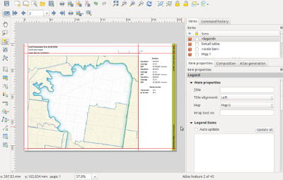


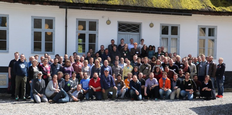
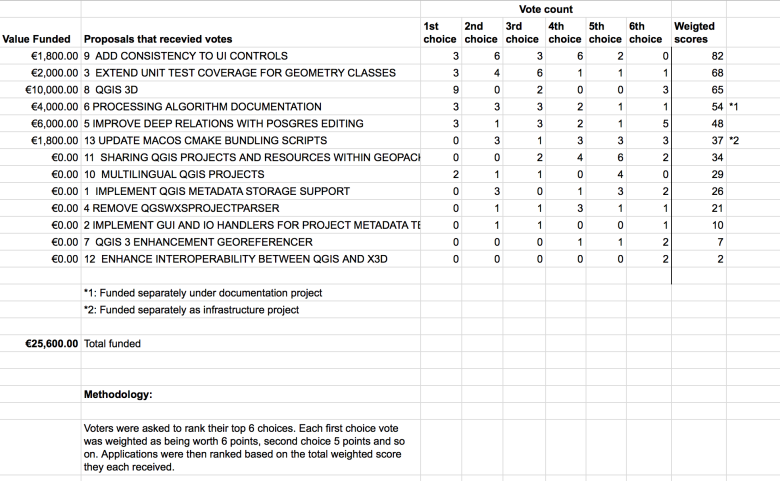
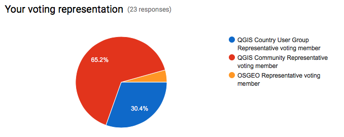


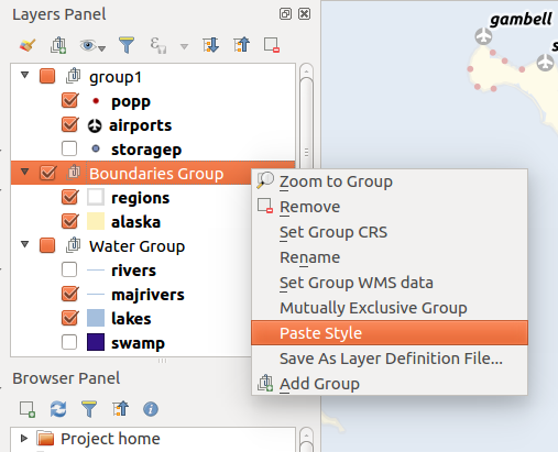
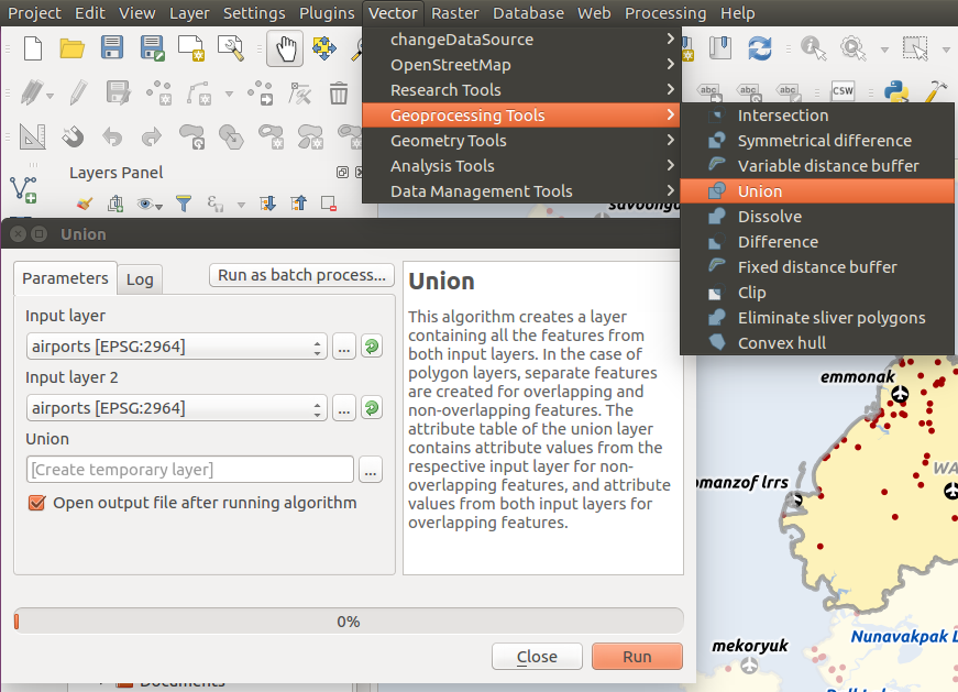
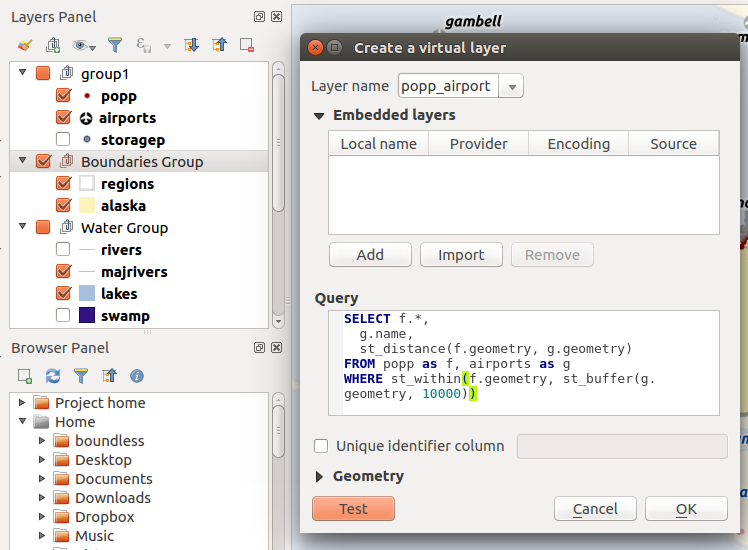
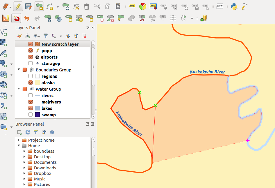


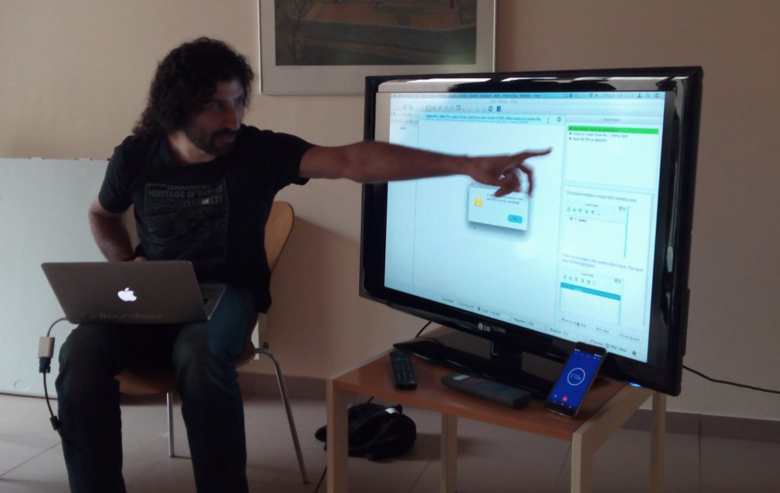


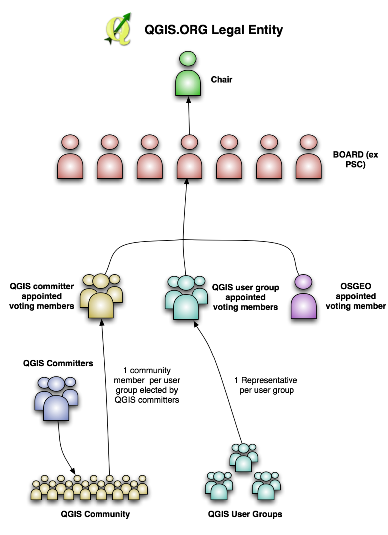


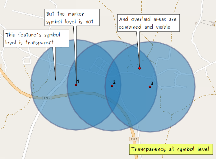
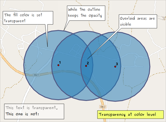

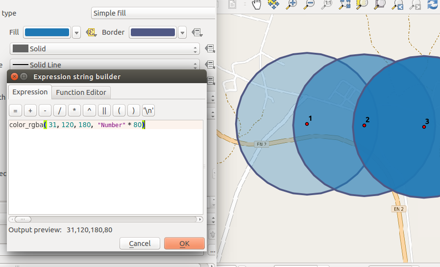
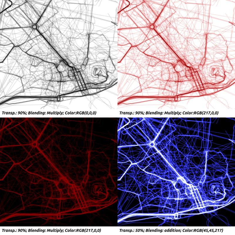


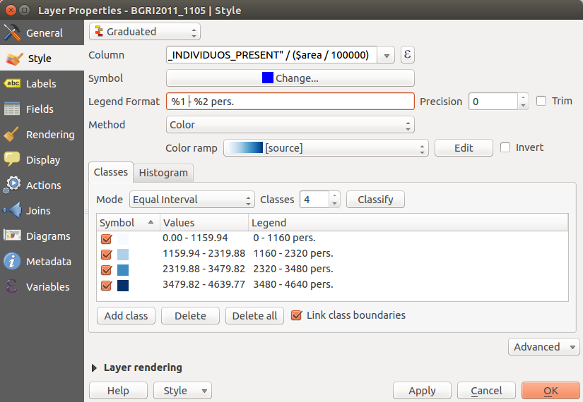
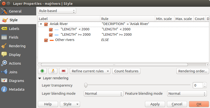
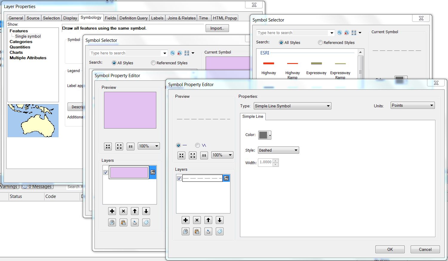
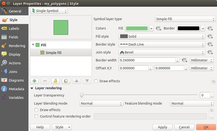
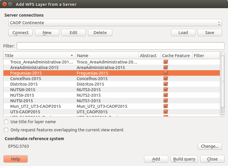
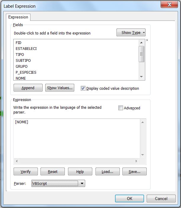
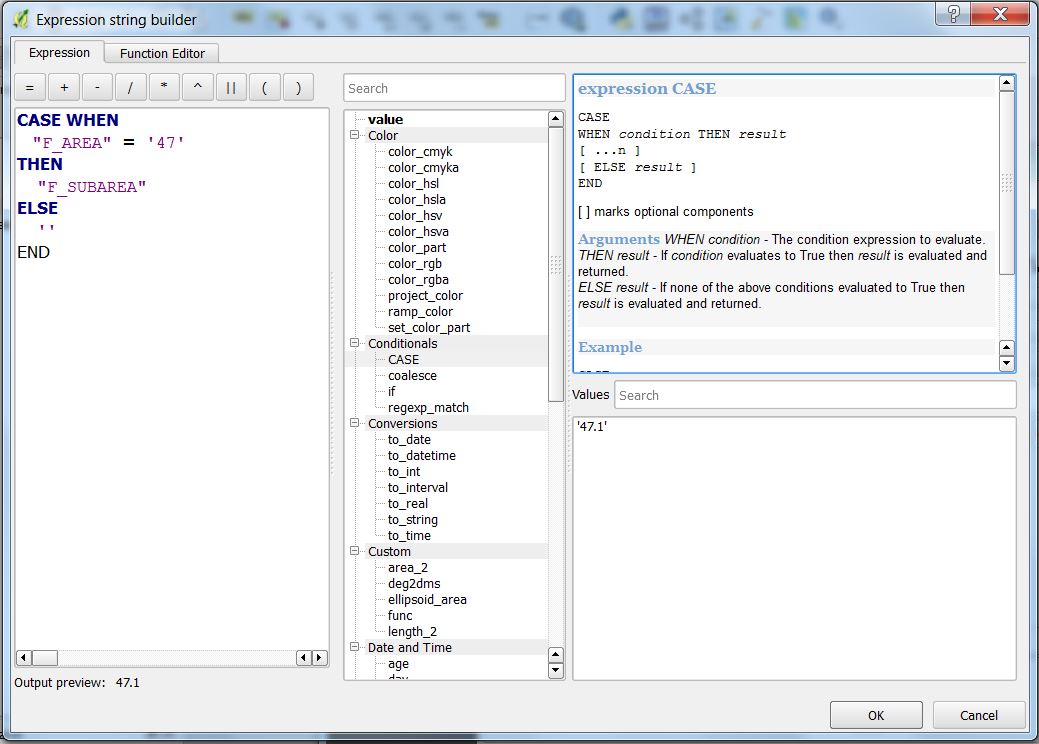
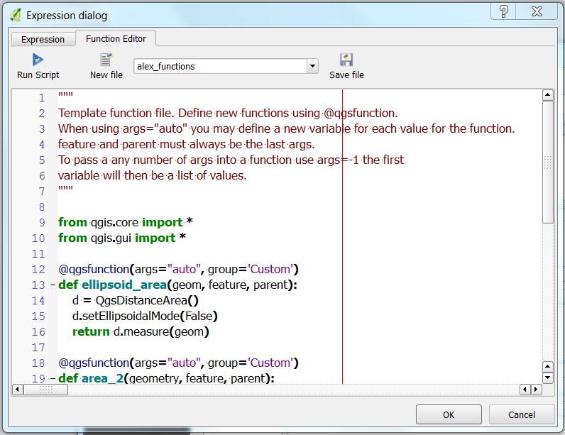

