Related Plugins and Tags

QGIS Planet

Mapping relationships between Neo4j spatial nodes with GeoPandas

Previously, we mapped neo4j spatial nodes. This time, we want to take it one step further and map relationships.

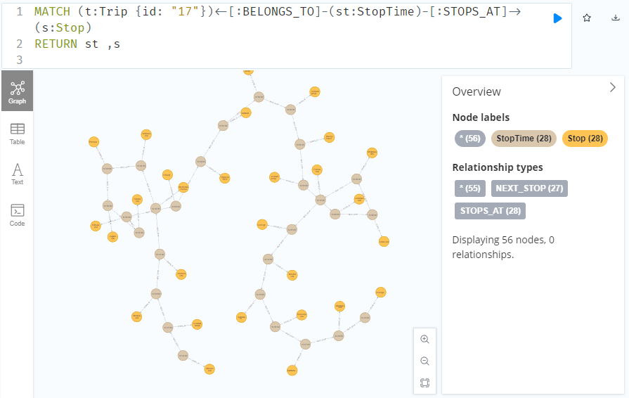
A prime example, are the relationships between GTFS StopTime and Trip nodes. For example, this is the Cypher query to get all StopTime nodes of Trip 17:

MATCH 
    (t:Trip  {id: "17"})
    <-[:BELONGS_TO]-
    (st:StopTime) 
RETURN st

To get the stop locations, we also need to get the stop nodes:

MATCH 
    (t:Trip {id: "17"})
    <-[:BELONGS_TO]-
    (st:StopTime)
    -[:STOPS_AT]->
    (s:Stop)
RETURN st ,s

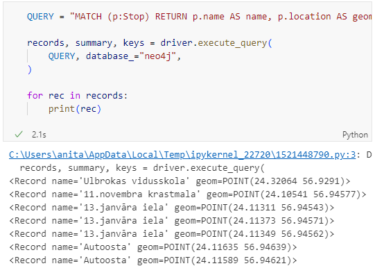
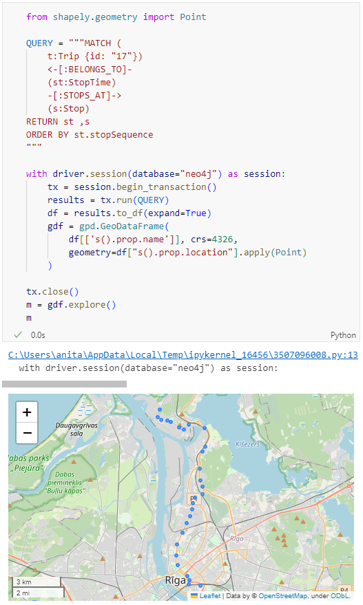
Adapting our code from the previous post, we can plot the stops:

from shapely.geometry import Point

QUERY = """MATCH (
    t:Trip {id: "17"})
    <-[:BELONGS_TO]-
    (st:StopTime)
    -[:STOPS_AT]->
    (s:Stop)
RETURN st ,s
ORDER BY st.stopSequence
"""

with driver.session(database="neo4j") as session:
    tx = session.begin_transaction()
    results = tx.run(QUERY)
    df = results.to_df(expand=True)
    gdf = gpd.GeoDataFrame(
        df[['s().prop.name']], crs=4326,
        geometry=df["s().prop.location"].apply(Point)
    )

tx.close() 
m = gdf.explore()
m

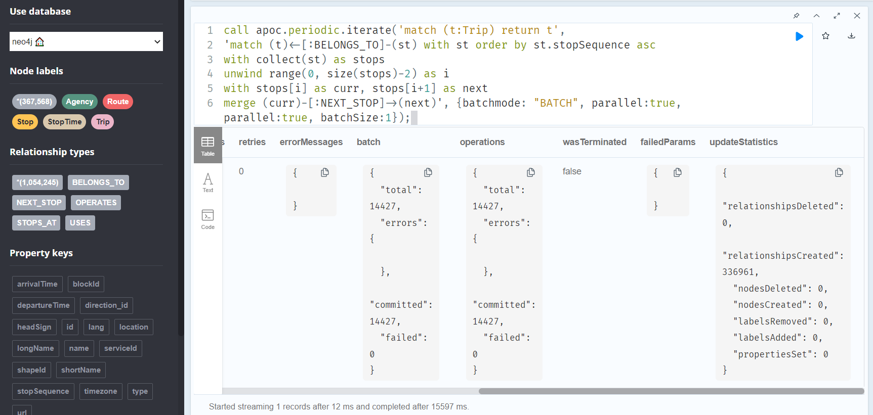
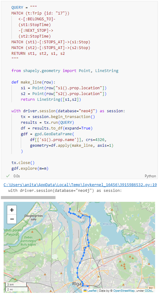
Ordering by stop sequence is actually completely optional. Technically, we could use the sorted GeoDataFrame, and aggregate all the points into a linestring to plot the route. But I want to try something different: we’ll use the NEXT_STOP relationships to get a DataFrame of the start and end stops for each segment:

QUERY = """
MATCH (t:Trip {id: "17"})
   <-[:BELONGS_TO]-
   (st1:StopTime)
   -[:NEXT_STOP]->
   (st2:StopTime)
MATCH (st1)-[:STOPS_AT]->(s1:Stop)
MATCH (st2)-[:STOPS_AT]->(s2:Stop)
RETURN st1, st2, s1, s2
"""

from shapely.geometry import Point, LineString

def make_line(row):
    s1 = Point(row["s1().prop.location"])
    s2 = Point(row["s2().prop.location"])
    return LineString([s1,s2])

with driver.session(database="neo4j") as session:
    tx = session.begin_transaction()
    results = tx.run(QUERY)
    df = results.to_df(expand=True)
    gdf = gpd.GeoDataFrame(
        df[['s1().prop.name']], crs=4326,
        geometry=df.apply(make_line, axis=1)
    )

tx.close() 
gdf.explore(m=m)

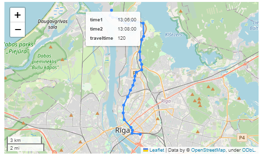
Finally, we can also use Cypher to calculate the travel time between two stops:

MATCH (t:Trip {id: "17"})
   <-[:BELONGS_TO]-
   (st1:StopTime)
   -[:NEXT_STOP]->
   (st2:StopTime)
MATCH (st1)-[:STOPS_AT]->(s1:Stop)
MATCH (st2)-[:STOPS_AT]->(s2:Stop)
RETURN st1.departureTime AS time1, 
   st2.arrivalTime AS time2, 
   s1.location AS geom1, 
   s2.location AS geom2, 
   duration.inSeconds(
      time(st1.departureTime), 
      time(st2.arrivalTime)
   ).seconds AS traveltime

As always, here’s the notebook: https://github.com/anitagraser/QGIS-resources/blob/master/qgis3/notebooks/neo4j.ipynb

Mapping Neo4j spatial nodes with GeoPandas

In the recent post Setting up a graph db using GTFS data & Neo4J, we noted that — unfortunately — Neomap is not an option to visualize spatial nodes anymore.

GeoPandas to the rescue!

But first we need the neo4j Python driver:

pip install neo4j

Then we can connect to our database. The default user name is neo4j and you get to pick the password when creating the database:

from neo4j import GraphDatabase

URI = "neo4j://localhost"
AUTH = ("neo4j", "password")

with GraphDatabase.driver(URI, auth=AUTH) as driver:
    driver.verify_connectivity()

Once we have confirmed that the connection works as expected, we can run a query:

QUERY = "MATCH (p:Stop) RETURN p.name AS name, p.location AS geom"

records, summary, keys = driver.execute_query(
    QUERY, database_="neo4j",
)

for rec in records:
    print(rec)

Nice. There we have our GTFS stops, their names and their locations. But how to put them on a map?

Conveniently, there is a to_db() function in the Neo4j driver:

import geopandas as gpd
import numpy as np

with driver.session(database="neo4j") as session:
    tx = session.begin_transaction()
    results = tx.run(QUERY)
    df = results.to_df(expand=True)
    df = df[df["geom[].0"]>0]
    gdf = gpd.GeoDataFrame(
        df['name'], crs=4326,
        geometry=gpd.points_from_xy(df['geom[].0'], df['geom[].1']))
    print(gdf)

tx.close() 

Since some of the nodes lack geometries, I added a quick and dirty hack to get rid of these nodes because — otherwise — gdf.explore() will complain about None geometries.

You can find this notebook at: https://github.com/anitagraser/QGIS-resources/blob/1e4ea435c9b1795ba5b170ddb176aa83689112eb/qgis3/notebooks/neo4j.ipynb

Next step will have to be the relationships. Stay posted.

Setting up a graph db using GTFS data & Neo4J

In a recent post, we looked into a graph-based model for maritime mobility data and how it may be represented in Neo4J. Today, I want to look into another type of mobility data: public transport schedules in GTFS format.

In this post, I’ll be using the public GTFS data for Riga since Riga is one of the demo sites for our current EMERALDS research project.

The workflow is heavily inspired by Bert Radke‘s post “Loading the UK GTFS data feed” from 2021 and his import Cypher script which I used as a template, adjusted to the requirements of the Riga dataset, and updated to recent Neo4J changes.

Here we go.

Since a GTFS export is basically a ZIP archive full of CSVs, we will be making good use of Neo4Js CSV loading capabilities. The basic script for importing the stops file and creating point geometries from lat and lon values would be:

LOAD CSV with headers 
FROM "file:///stops.txt" 
AS row 
CREATE (:Stop {
   stop_id: row["stop_id"],
   name: row["stop_name"], 
   location: point({
    longitude: toFloat(row["stop_lon"]),
    latitude: toFloat(row["stop_lat"])
    })
})

This requires that the stops.txt is located in the import directory of your Neo4J database. When we run the above script and the file is missing, Neo4J will tell us where it tried to look for it. In my case, the directory ended up being:

C:\Users\Anita\.Neo4jDesktop\relate-data\dbmss\dbms-72882d24-bf91-4031-84e9-abd24624b760\import

So, let’s put all GTFS CSVs into that directory and we should be good to go.

Let’s start with the agency file:

load csv with headers from
'file:///agency.txt' as row
create (a:Agency {
   id: row.agency_id, 
   name: row.agency_name, 
   url: row.agency_url, 
   timezone: row.agency_timezone, 
   lang: row.agency_lang
});

… Added 1 label, created 1 node, set 5 properties, completed after 31 ms.

The routes file does not include agency info but, luckily, there is only one agency, so we can hard-code it:

load csv with headers from
'file:///routes.txt' as row
match (a:Agency {id: "rigassatiksme"})
create (a)-[:OPERATES]->(r:Route {
   id: row.route_id, 
   shortName: row.route_short_name,
   longName: row.route_long_name, 
   type: toInteger(row.route_type)
});

… Added 81 labels, created 81 nodes, set 324 properties, created 81 relationships, completed after 28 ms.

From stops, I’m removing non-existent or empty columns:

load csv with headers from
'file:///stops.txt' as row
create (s:Stop {
   id: row.stop_id, 
   name: row.stop_name, 
   location: point({
      latitude: toFloat(row.stop_lat), 
      longitude: toFloat(row.stop_lon)
   }),
   code: row.stop_code
});

… Added 1671 labels, created 1671 nodes, set 5013 properties, completed after 71 ms.

From trips, I’m also removing non-existent or empty columns:

load csv with headers from
'file:///trips.txt' as row
match (r:Route {id: row.route_id})
create (r)<-[:USES]-(t:Trip {
   id: row.trip_id, 
   serviceId: row.service_id,
   headSign: row.trip_headsign, 
   direction_id: toInteger(row.direction_id),
   blockId: row.block_id,
   shapeId: row.shape_id
});

… Added 14427 labels, created 14427 nodes, set 86562 properties, created 14427 relationships, completed after 875 ms.

Slowly getting there. We now have around 16k nodes in our graph:

Finally, it’s stop times time. This is where the serious information is. This file is much larger than all previous ones with over 300k lines (i.e. times when an PT vehicle stops).

This requires another tweak to Bert’s script since using periodic commit is not supported anymore: The PERIODIC COMMIT query hint is no longer supported. Please use CALL { … } IN TRANSACTIONS instead. So I ended up using the following, based on https://community.neo4j.com/t/best-practice-for-replacement-of-using-periodic-commit-to-call-in-transactions/48636/2:

:auto
load csv with headers from
'file:///stop_times.txt' as row
CALL { with row
match (t:Trip {id: row.trip_id}), (s:Stop {id: row.stop_id})
create (t)<-[:BELONGS_TO]-(st:StopTime {
   arrivalTime: row.arrival_time, 
   departureTime: row.departure_time,
   stopSequence: toInteger(row.stop_sequence)})-[:STOPS_AT]->(s)
} IN TRANSACTIONS OF 10 ROWS;

… Added 351388 labels, created 351388 nodes, set 1054164 properties, created 702776 relationships, completed after 1364220 ms.

As you can see, this took a while. But now we have all nodes in place:

The final statement adds additional relationships between consecutive stop times:

call apoc.periodic.iterate('match (t:Trip) return t',
'match (t)<-[:BELONGS_TO]-(st) with st order by st.stopSequence asc
with collect(st) as stops
unwind range(0, size(stops)-2) as i
with stops[i] as curr, stops[i+1] as next
merge (curr)-[:NEXT_STOP]->(next)', {batchmode: "BATCH", parallel:true, parallel:true, batchSize:1});

This fails with: There is no procedure with the name apoc.periodic.iterate registered for this database instance. Please ensure you've spelled the procedure name correctly and that the procedure is properly deployed.

So, let’s install APOC. That’s a plugin which we can install into our database from within Neo4J Desktop:

After restarting the db, we can run the query:

No errors. Sounds good.

Let’s have a look at what we ended up with. Here are 25 random Trips. I expanded one of them to show its associated StopTimes. We can see the relations between consecutive StopTimes and I’ve expanded the final five StopTimes to show their linked Stops:

I also wanted to visualize the stops on a map. And there used to be a neat app called Neomap which can be installed easily:

However, Neomap does not seem to be compatible with the latest Neo4J:

So this final step will have to wait for another time.

Exploring a hierarchical graph-based model for mobility data representation and analysis

Today’s post is a first quick dive into Neo4J (really just getting my toes wet). It’s based on a publicly available Neo4J dump containing mobility data, ship trajectories to be specific. You can find this data and the setup instructions at:

Maryam Maslek ELayam, Cyril Ray, & Christophe Claramunt. (2022). A hierarchical graph-based model for mobility data representation and analysis [Data set]. Zenodo. https://doi.org/10.5281/zenodo.6405212

I was made aware of this work since they cited MovingPandas in their paper in Data & Knowledge Engineering“The implementation combines several open source tools such as Python, MovingPandas library, Uber H3 index, Neo4j graph database management system”

Once set up, this gives us a database with three hierarchical levels:

Neo4j comes with a nice graphical browser that lets us explore the data. We can switch between levels and click on individual node labels to get a quick preview:

Level 2 is a generalization / aggregation of level 1. Expanding the graph of one of the level 2 nodes shows its connection to level 1. For example, the level 2 port node “Audierne” actually refers to two level 1 nodes:

Every “road” level 1 relationship between ports provide information about the ship, its arrival, departure, travel time, and speed. We can see that this two level 1 ports must be pretty close since travel times are only 5 minutes:

Further expanding one of the port level 1 nodes shows its connection to waypoints of level1:

Switching to level 2, we gain access to nodes of type Traj(ectory). Additionally, the road level 2 relationships represent aggregations of the trajectories, for example, here’s a relationship with only one associated trajectory:

There are also some odd relationships, for example, trajectory 43 has two ends and begins relationships and there are also two road relationships referencing this trajectory (with identical information, only differing in their automatic <id>). I’m not yet sure if that is a feature or a bug:

On level 1, we also have access to ship nodes. They are connected to ports and waypoints. However, exploring them visually is challenging. Things look fine at first:

But after a while, once all relationships have loaded, we have it: the MIGHTY BALL OF YARN ™:

I guess this is the point where it becomes necessary to get accustomed to the query language. And no, it’s not SQL, it is Cypher. For example, selecting a specific trajectory with id 0, looks like this:

 MATCH (t1 {traj_id: 0}) RETURN t1

But more on this another time.


This post is part of a series. Read more about movement data in GIS.

Back to Top

Sustaining Members