Related Plugins and Tags

QGIS Planet

New MovingPandas tutorial: taking OGC Moving Features full circle with MF-JSON

Last week, I had the pleasure to meet some of the people behind the OGC Moving Features Standard Working group at the IEEE Mobile Data Management Conference (MDM2024). While chatting about the Moving Features (MF) support in MovingPandas, I realized that, after the MF-JSON update & tutorial with official sample post, we never published a complete tutorial on working with MF-JSON encoded data in MovingPandas.

The current MovingPandas development version (to be release as version 0.19) supports:

  • Reading MF-JSON MovingPoint (single trajectory features and trajectory collections)
  • Reading MF-JSON Trajectory
  • Writing MovingPandas Trajectories and TrajectoryCollections to MF-JSON MovingPoint

This means that we can now go full circle: reading — writing — reading.

Reading MF-JSON

Both MF-JSON MovingPoint encoding and Trajectory encoding can be read using the MovingPandas function read_mf_json(). The complete Jupyter notebook for this tutorial is available in the project repo.

Here we read one of the official MF-JSON MovingPoint sample files:

traj = mpd.read_mf_json('data/movingfeatures.json')

Writing MF-JSON

To write MF-JSON, the Trajectory and TrajectoryCollection classes provide a to_mf_json() function:

The resulting Python dictionary in MF-JSON MovingPoint encoding can then be saved to a JSON file, and then read again:

import json
with open('mf1.json', 'w') as json_file:
    json.dump(mf_json, json_file, indent=4)

Similarly, we can read any arbitrary trajectory data set and save it to MF-JSON.

For example, here we use our usual Geolife sample:

gdf = gp.read_file('data/demodata_geolife.gpkg')
tc = mpd.TrajectoryCollection(gdf, 'trajectory_id', t='t')
mf_json = tc.to_mf_json(temporal_columns=['sequence'])

And reading again

import json
with open('mf5.json', 'w') as json_file:
    json.dump(mf_json, json_file, indent=4)
tc = mpd.read_mf_json('mf5.json', traj_id_property='trajectory_id' )

Conclusion

The implemented MF-JSON support covers the basic usage of the encodings. There are some fine details in the standard, such as the distinction of time-varying attribute with linear versus step-wise interpolation, which MovingPandas currently does not support.

If you are working with movement data, I would appreciate if you can give the improved MF-JSON support a spin and report back with your experiences.

Getting started with pygeoapi processes

Today’s post is a quick introduction to pygeoapi, a Python server implementation of the OGC API suite of standards. OGC API provides many different standards but I’m particularly interested in OGC API – Processes which standardizes geospatial data processing functionality. pygeoapi implements this standard by providing a plugin architecture, thereby allowing developers to implement custom processing workflows in Python.

I’ll provide instructions for setting up and running pygeoapi on Windows using Powershell. The official docs show how to do this on Linux systems. The pygeoapi homepage prominently features instructions for installing the dev version. For first experiments, however, I’d recommend using a release version instead. So that’s what we’ll do here.

As a first step, lets install the latest release (0.16.1 at the time of writing) from conda-forge:

conda create -n pygeoapi python=3.10
conda activate pygeoapi
mamba install -c conda-forge pygeoapi

Next, we’ll clone the GitHub repo to get the example config and datasets:

cd C:\Users\anita\Documents\GitHub\
git clone https://github.com/geopython/pygeoapi.git
cd pygeoapi\

To finish the setup, we need some configurations:

cp pygeoapi-config.yml example-config.yml  
# There is a known issue in pygeoapi 0.16.1: https://github.com/geopython/pygeoapi/issues/1597
# To fix it, edit the example-config.yml: uncomment the TinyDB option in the server settings (lines 51-54)

$Env:PYGEOAPI_CONFIG = "F:/Documents/GitHub/pygeoapi/example-config.yml"
$Env:PYGEOAPI_OPENAPI = "F:/Documents/GitHub/pygeoapi/example-openapi.yml"
pygeoapi openapi generate $Env:PYGEOAPI_CONFIG --output-file $Env:PYGEOAPI_OPENAPI

Now we can start the server:

pygeoapi serve

And once the server is running, we can send requests, e.g. the list of processes:

curl.exe http://localhost:5000/processes

And, of course, execute the example “hello-world” process:

curl.exe --% -X POST http://localhost:5000/processes/hello-world/execution -H "Content-Type: application/json" -d "{\"inputs\":{\"name\": \"hi there\"}}"

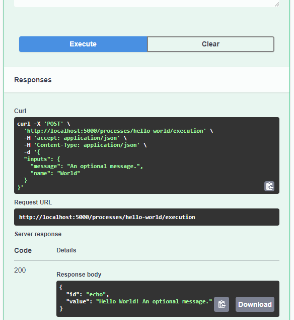
As you can see, writing JSON content for curl is a pain. Luckily, pyopenapi comes with a nice web GUI, including Swagger UI for playing with all the functionality, including the hello-world process:

It’s not really a geospatial hello-world example, but it’s a first step.

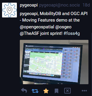
Finally, I wan’t to leave you with a teaser since there are more interesting things going on in this space, including work on OGC API – Moving Features as shared by the pygeoapi team recently:

So, stay tuned.

Back to Top

Sustaining Members