Related Plugins and Tags

QGIS Planet

Software quality in QGIS

According to the definition of software quality given by french Wikipedia

An overall assessment of quality takes into account external factors, directly observable by the user, as well as internal factors, observable by engineers during code reviews or maintenance work.

I have chosen in this article to only talk about the latter. The quality of software and more precisely QGIS is therefore not limited to what is described here. There is still much to say about:

  • Taking user feedback into account,
  • the documentation writing process,
  • translation management,
  • interoperability through the implementation of standards,
  • the extensibility using API,
  • the reversibility and resilience of the open source model…

These are subjects that we care a lot and deserve their own article.

I will focus here on the following issue: QGIS is free software and allows anyone with the necessary skills to modify the software. But how can we ensure that the multiple proposals for modifications to the software contribute to its improvement and do not harm its future maintenance?

Self-discipline

All developers contributing to QGIS code doesn’t belong to the same organization. They don’t all live in the same country, don’t necessarily have the same culture and don’t necessarily share the same interests or ambitions for the software. However, they share the awareness of modifying a common good and the desire to take care of it.

This awareness transcends professional awareness, the developer not only has a responsibility towards his employer, but also towards the entire community of users and contributors to the software.

This self-discipline is the foundation of the quality of the contributions of software like QGIS.

However, to err is human and it is essential to carry out checks for each modification proposal.

Automatic checks

With each modification proposal (called Pull Request or Merge Request), the QGIS GitHub platform automatically launches a set of automatic checks.
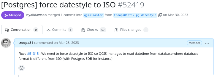
Example of proposed modification
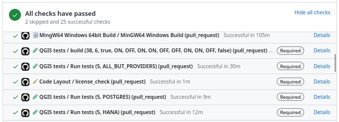
Result of automatic checks on a modification proposal

The first of these checks is to build QGIS on the different systems on which it is distributed (Linux, Windows, MacOS) by integrating the proposed modification. It is inconceivable to integrate a modification that would prevent the application from being built on one of these systems.

The tests

The first problem posed by a proposed modification is the following “How can we be sure that what is going to be introduced does not break what already exists?”

To validate this assertion, we rely on automatic tests. This is a set of micro-programs called tests, which only purpose is to validate that part of the application behaves as expected. For example, there is a test which validates that when the user adds an entry in a data layer, then this entry is then present in the data layer. If a modification were to break this behavior, then the test would fail and the proposal would be rejected (or more likely corrected).

This makes it possible in particular to avoid regressions (they are very often called non-regression tests) and also to qualify the expected behavior.

There are approximately 1.3 Million lines of code for the QGIS application and 420K lines of test code, a ratio of 1 to 3. The presence of tests is mandatory for adding functionality, therefore the quantity of test code increases with the quantity of application code.
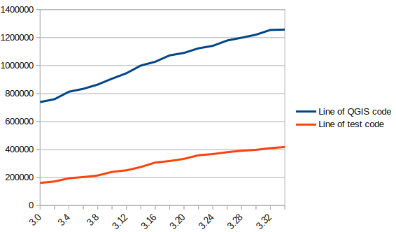
In blue the number of lines of code in QGIS, in red the number of lines of tests

There are currently over 900 groups of automatic tests in QGIS, most of which run in less than 2 seconds, for a total execution time of around 30 minutes.

We also see that certain parts of the QGIS code – the most recent – are better covered by the tests than other older ones. Developers are gradually working to improve this situation to reduce technical debt.

Code checks

Analogous to using a spell checker when writing a document, we carry out a set of quality checks on the source code. We check, for example, that the proposed modification does not contain misspelled words or “banned” words, that the API documentation has been correctly written or that the modified code respects certain formal rules of the programming language.

We recently had the opportunity to add a check based on the clang-tidy tool. The latter relies on the Clang compiler. It is capable of detecting programming errors by carrying out a static analysis of the code.

Clang-tidy is, for example, capable of detecting “narrowing conversions”.

Example of detecting “narrowing conversions”

In the example above, Clang-tidy detects that there has been a “narrowing conversion” and that the value of the port used in the network proxy configuration “may” be corrupted. In this case, this problem was reported on the QGIS issues platform and had to be corrected.

At that time, clang-tidy was not in place. Its use would have made it possible to avoid this anomaly and all the steps which led to its correction (exhaustive description of the issue, multiple exchanges to be able to reproduce it, investigation, correction, review of the modification), meaning a significant amount of human time which could thus have been avoided.

Peer review

A proposed modification that would validate all of the automatic checks described above would not necessarily be integrated into the QGIS code automatically. In fact, its code may be poorly designed or the modification poorly thought out. The relevance of the functionality may be doubtful, or duplicated with another. The integration of the modification would therefore potentially cause a burden for the people in charge of the corrective or evolutionary maintenance of the software.

It is therefore essential to include a human review in the process of accepting a modification.

This is more of a rereading of the substance of the proposal than of the form. For the latter, we favor the automatic checks described above in order to simplify the review process.

Therefore, human proofreading takes time, and this effort is growing with the quantity of modifications proposed in the QGIS code. The question of its funding arises, and discussions are in progress. The QGIS.org association notably dedicates a significant part of its budget to fund code reviews.
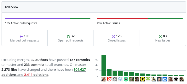
More than 100 modification proposals were reviewed and integrated during the month of December 2023. More than 30 different people contributed. More than 2000 files have been modified.

Therefore the wait for a proofreading can sometimes be long. It is also often the moment when disagreements are expressed. It is therefore a phase which can prove frustrating for contributors, but it is an important and rich moment in the community life of a free project.

To be continued !

As a core QGIS developer, and as a pure player OpenSource company, we believe it is fundamental to be involved in each step of the contribution process.

We are investing in the review process, improving automatic checks, and in the QGIS quality process in general. And we will continue to invest in these topics in order to help make QGIS a long-lasting and stable software.

If you would like to contribute or simply learn more about QGIS, do not hesitate to contact us at [email protected] and consult our QGIS support proposal.

(Fr) Oslandia recrute : ingénieur(e) développement C++ / Python – OSL2011B

Sorry, this entry is only available in French.

(Fr) Oslandia recrute : développeur(se) C++ et Python

Sorry, this entry is only available in French.

QGIS 3 compiling on Windows

As the Oslandia team work exclusively on GNU/Linux, the exercise of compiling QGIS 3 on Windows 8 is not an everyday’s task :). So we decided to share our experience, we bet that will help some of you.

Cygwin

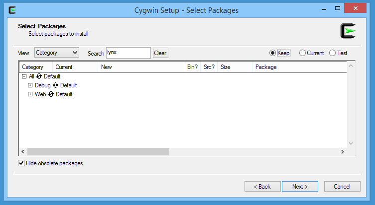
The first step is to download Cygwin and to install it in the directory C:\cygwin (instead of the default C:\cygwin64). During the installation, select the lynx package:


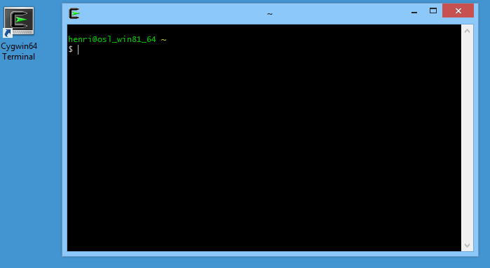
Once installed, you have to click on the Cygwin64 Terminal icon newly created on your desktop:

Then, we’re able to install dependencies and download some other installers:

[pastacode lang=”bash” manual=”%24%20cd%20%2Fcygdrive%2Fc%2FUsers%2Fhenri%2FDownloads%0A%24%20lynx%20-source%20rawgit.com%2Ftranscode-open%2Fapt-cyg%2Fmaster%2Fapt-cyg%20%3E%20apt-cyg%0A%24%20install%20apt-cyg%20%2Fbin%0A%24%20apt-cyg%20install%20wget%20git%20flex%20bison%0A%24%20wget%20http%3A%2F%2Fdownload.microsoft.com%2Fdownload%2FD%2F2%2F3%2FD23F4D0F-BA2D-4600-8725-6CCECEA05196%2Fvs_community_ENU.exe%0A%24%20chmod%20u%2Bx%20vs_community_ENU.exe%0A%24%20wget%20https%3A%2F%2Fcmake.org%2Ffiles%2Fv3.7%2Fcmake-3.7.2-win64-x64.msi%0A%24%20wget%20http%3A%2F%2Fdownload.osgeo.org%2Fosgeo4w%2Fosgeo4w-setup-x86_64.exe%0A%24%20chmod%20u%2Bx%20osgeo4w-setup-x86_64.exe” message=”” highlight=”” provider=”manual”/]

CMake

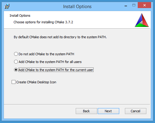
The next step is to install CMake. To do that, double clic on the file cmake-3.7.2-win64-x64.msi previously downloaded with wget. You should choose the next options during the installation:


Visual Studio

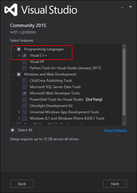
Then, we have to install Visual Studio and C++ tools. Double click on the vs_community_ENU.exe file and select the Custom installation. On the next page, you have to select Visual C++ chekbox:


OSGeo4W

In order to compile QGIS, some dependencies provided by the OSGeo4W installer are required. Double click on osgeo4w-setup-x86_64.exe and select the Advanced Install mode. Then, select the next packages:

  •  expat
  • fcgi
  • gdal
  • grass
  • gsl-devel
  • iconv
  • libzip-devel
  • libspatialindex-devel
  • pyqt5
  • python3-devel
  • python3-qscintilla
  • python3-nose2
  • python3-future
  • python3-pyyaml
  • python3-mock
  • python3-six
  • qca-qt5-devel
  • qca-qt5-libs
  • qscintilla-qt5
  • qt5-devel
  • qt5-libs-debug
  • qtwebkit-qt5-devel
  • qtwebkit-qt5-libs-debug
  • qwt-devel-qt5
  • sip-qt5
  • spatialite
  • oci
  • qtkeychain

QGIS

To start this last step, we have to create a file C:\OSGeo4W\OSGeo4W-dev.bat containing something like:

[pastacode lang=”bash” manual=”%40echo%20off%20%0Aset%20OSGEO4W_ROOT%3DC%3A%5COSGeo4W64%0Acall%20%22%25OSGEO4W_ROOT%25%5Cbin%5Co4w_env.bat%22%20%0Acall%20%22%25OSGEO4W_ROOT%25%5Cbin%5Cqt5_env.bat%22%20%0Acall%20%22%25OSGEO4W_ROOT%25%5Cbin%5Cpy3_env.bat%22%20%0Aset%20VS140COMNTOOLS%3D%25PROGRAMFILES(x86)%25%5CMicrosoft%20Visual%20Studio%2014.0%5CCommon7%5CTools%5C%20%0Acall%20%22%25PROGRAMFILES(x86)%25%5CMicrosoft%20Visual%20Studio%2014.0%5CVC%5Cvcvarsall.bat%22%20amd64%20%0Aset%20INCLUDE%3D%25INCLUDE%25%3B%25PROGRAMFILES(x86)%25%5CMicrosoft%20SDKs%5CWindows%5Cv7.1A%5Cinclude%20%0Aset%20LIB%3D%25LIB%25%3B%25PROGRAMFILES(x86)%25%5CMicrosoft%20SDKs%5CWindows%5Cv7.1A%5Clib%20%0Apath%20%25PATH%25%3B%25PROGRAMFILES%25%5CCMake%5Cbin%3Bc%3A%5Ccygwin%5Cbin%20%0A%40set%20GRASS_PREFIX%3D%22%25OSGEO4W_ROOT%25%5Capps%5Cgrass%5Cgrass-7.2.1%20%0A%40set%20INCLUDE%3D%25INCLUDE%25%3B%25OSGEO4W_ROOT%25%5Cinclude%20%0A%40set%20LIB%3D%25LIB%25%3B%25OSGEO4W_ROOT%25%5Clib%3B%25OSGEO4W_ROOT%25%5Clib%20%0A%0A%40cmd%20″ message=”” highlight=”” provider=”manual”/]

According to your environment, some variables should probably be adapted. Then in the Cygwin terminal:

[pastacode lang=”bash” manual=”%24%20cd%20C%3A%5C%0A%24%20git%20clone%20git%3A%2F%2Fgithub.com%2Fqgis%2FQGIS.git%0A%24%20.%2FOSGeo4W-dev.bat%0A%3E%20cd%20QGIS%2Fms-windows%2Fosgeo4w” message=”” highlight=”” provider=”manual”/]

In this directory, you have to edit the file package-nightly.cmd to replace:

[pastacode lang=”bash” manual=”cmake%20-G%20Ninja%20%5E” message=”” highlight=”” provider=”manual”/]

by:

[pastacode lang=”bash” manual=”cmake%20-G%20%22Visual%20Studio%2014%202015%20Win64%22%20%5E” message=”” highlight=”” provider=”manual”/]

Moreover, we had to update the environment variable SETUAPI_LIBRARY according to the current position of the Windows Kits file SetupAPI.Lib:

[pastacode lang=”bash” manual=”set%20SETUPAPI_LIBRARY%3DC%3A%5CProgram%20Files%20(x86)%5CWindows%20Kits%5C8.1%5CLib%5Cwinv6.3%5Cum%5Cx64%5CSetupAPI.Lib” message=”” highlight=”” provider=”manual”/]

And finally, we just have to compile with the next command:

[pastacode lang=”markup” manual=”%3E%20package-nightly.cmd%202.99.0%201%20qgis-dev%20x86_64″ message=”” highlight=”” provider=”manual”/]

Victory!

And see you soon for the generation of OSGEO4W packages 😉

Source

https://github.com/qgis/QGIS/blob/ab859c9bdf8a529df9805ff54e7250921a74d877/doc/msvc.t2t


Auxiliary Storage support in QGIS 3

For those who know how powerful QGIS can be using data defined widgets and expressions almost anywhere in styling and labeling settings, it remains today quite complex to store custom data.

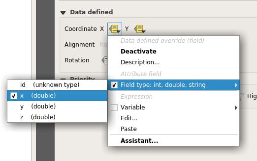
For instance, moving a simple label using the label toolbar is not straightforward, that wonderful toolbar remains desperately greyed-out for manual labeling tweaks

…unless you do the following:

  • Set your vector layer editable (yes, it’s not possible with readonly data)
  • Add two columns in your data
  • Link the X property position to a column and the Y position to another


the Move Label map tool becomes available and ready to be used (while your layer is editable). Then, if you move a label, the underlying data is modified to store the position. But what happened if you want to fully use the Change Label map tool (color, size, style, and so on)?


Well… You just have to add a new column for each property you want to manage. No need to tell you that it’s not very convenient to use or even impossible when your data administrator has set your data in readonly mode…

A plugin, made some years ago named EasyCustomLabeling was made to address that issue. But it kept being full of caveats, like a dependency to another plugin (Memory layer saver) for persistence, or a full copy of the layer to label inside a memory layer which indeed led to loose synchronisation with the source layer.

Two years ago, the French Agence de l’eau Adour Garonne (a water basin agency) and the Ministry in charge of Ecology asked Oslandia to think out QGIS Enhancement proposals to port that plugin into QGIS core, among a few other things like labeling connectors or curved labels enhancements.

Those QEPs were accepted and we could work on the real implementation, so here we are, Auxiliary storage has now landed in master!

How

The aim of auxiliary storage is to propose a more integrated solution to manage these data defined properties :

  • Easy to use (one click)
  • Transparent for the user (map tools always available by default when labeling is activated)
  • Do not update the underlying data (it should work even when the layer is not editable)
  • Keep in sync with the datasource (as much as possible)
  • Store this data along or inside the project file

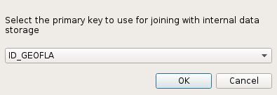
As said above, thanks to the Auxiliary Storage mechanism, map tools like Move Label, Rotate Label or Change Label are available by default. Then, when the user select the map tool to move a label and click for the first time on the map, a simple question is asked allowing to select a primary key :

Primary key choice dialog – (YES, you NEED a primary key for any data management)

From that moment on, a hidden table is transparently created to store all data defined values (positions, rotations, …) and joined to the original layer thanks to the primary key previously selected. When you move a label, the corresponding property is automatically created in the auxiliary layer. This way, the original data is not modified but only the joined auxiliary layer!

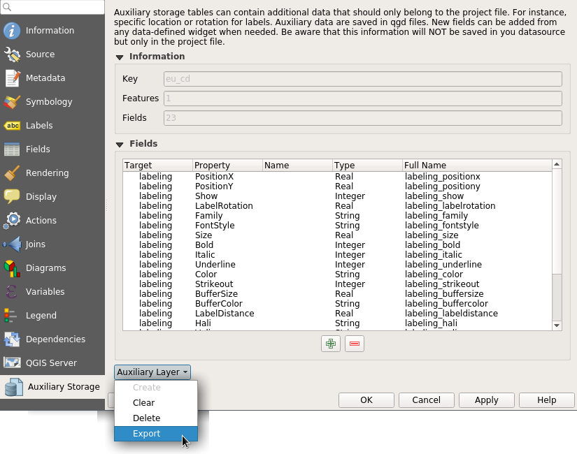
A new tab has been added in vector layer properties to manage the Auxiliary Storage mechanism. You can retrieve, clean up, export or create new properties from there :

Where the auxiliary data is really saved between projects?

We end up in using a light SQLite database which, by default, is just 8 Ko! When you save your project with the usual extension .qgs, the SQLite database is saved at the same location but with a different extension : .qgd.

Two thoughts with that choice: 

  • “Hey, I would like to store geometries, why no spatialite instead? “

Good point. We tried that at start in fact. But spatialite database initializing process using QGIS spatialite provider was found too long, really long. And a raw spatialite table weight about 4 Mo, because of the huge spatial reference system table, the numerous spatial functions and metadata tables. We chose to fall back onto using sqlite through OGR provider and it proved to be fast and stable enough. If some day, we achieve in merging spatialite provider and GDAL-OGR spatialite provider, with options to only create necessary SRS and functions, that would open news possibilities, like storing spatial auxiliary data.

  • “Does that mean that when you want to move/share a QGIS project, you have to manually manage these 2 files to keep them in the same location?!”

True, and dangerous isn’t it? Users often forgot auxiliary files with EasyCustomLabeling plugin.  Hence, we created a new format allowing to zip several files : .qgz.  Using that format, the SQLite database project.qgd and the regular project.qgs file will be embedded in a single project.zip file. WIN!!

Changing the project file format so that it can embed, data, fonts, svg was a long standing feature. So now we have a format available for self hosted QGIS project. Plugins like offline editing, Qconsolidate and other similar that aim at making it easy to export a portable GIS database could take profit of that new storage container.

Now, some work remains to add labeling connectors capabilities,  allow user to draw labeling paths by hand. If you’re interested in making this happen, please contact us!


More information

A full video showing auxiliary storage capabilities:


QEP: https://github.com/qgis/QGIS-Enhancement-Proposals/issues/27

PR New Zip format: https://github.com/qgis/QGIS/pull/4845

PR Editable Joined layers: https://github.com/qgis/QGIS/pull/4913

PR Auxiliary Storage: https://github.com/qgis/QGIS/pull/5086

Back to Top

Sustaining Members