Call for Proposals: QGIS Website Overhaul 2023/2024
 Background
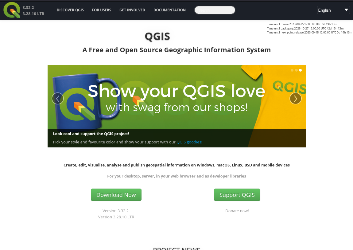
Our web site (https://qgis.org) dates back to 2013, it is time for a revision!
As well as modernizing the look and feel of the site, we want the content to be updated to represent changes in the maturity of the project.
We want to appeal to new audiences, especially business and NGO decision makers (in particular the experience for the front pages), whilst still maintaining appeal to grass roots users (especially the lower level pages which contain many technical details and community collaboration notes).
We want to enhance our fund raising efforts through a site that encourages people to contribute to, as well as take from, the project.
 Existing effort
First some key links:
- Current web site: https://github.com/qgis/QGIS-Website
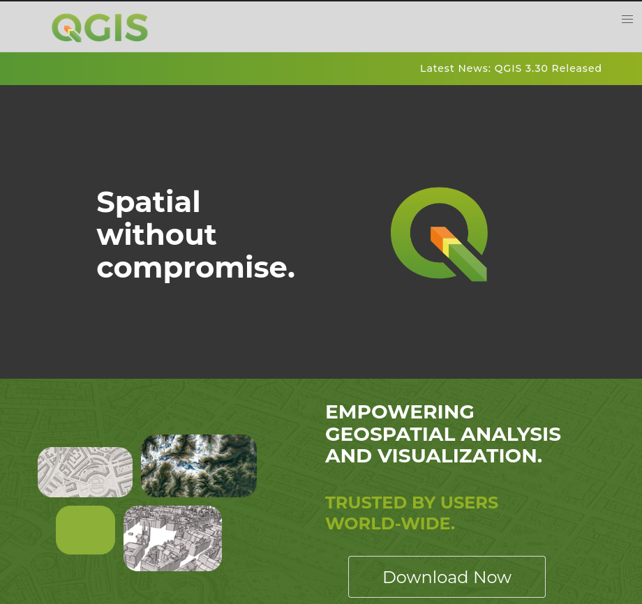
- Design for new web site landing page: https://qgis.github.io/QGIS-Hugo/
- Design for new web site (figma): https://www.figma.com/file/1jFYgq9R5nwHChf4HhhHpW/QGIS-(Copy)?type=design&node-id=301-299&mode=design&t=rvdeAl4RSuzKJftu-0
- Code for new web site (what we have built so far): https://github.com/qgis/QGIS-Hugo
- Plugins web site: https://plugins.qgis.org
- QGIS Documentation Site: https://www.qgis.org/en/docs/index.html
- QGIS User Manual: https://docs.qgis.org/3.28/en/docs/user_manual/
- QGIS Server Manual: https://docs.qgis.org/3.28/en/docs/server_manual/
- Gentle Introduction to GIS: https://docs.qgis.org/3.28/en/docs/gentle_gis_introduction/
- QGIS Python Cookbook: https://docs.qgis.org/3.28/en/docs/pyqgis_developer_cookbook/
- QGIS C++ API Documentation: https://api.qgis.org/api/3.28/
- QGIS Python API Documentation: https://qgis.org/pyqgis/3.28/
- QGIS Certification and Changelog: https://changelog.qgis.org/en/
The above websites were created with a mix of technologies:
- Sphinx (rst)
- Doxygen
- Custom Django Apps
It will not be possible to unify the technology used for all of the above sites, but we want all of the web sites to have a cohesive appearance and the navigation flow between them to be seamless. For the main website at https://qgis.org and its child pages, we want to re-implement the site to provide a new experience – according to the design we have laid out in our figma board. Note that we want to follow this design. Some small tweaks will be fine but we are not looking for a ‘from scratch’ re-implementation of our design.
This will be our website for the next 10 years – you need to hand it over to us in a way that we can continue working on it and maintaining it without your intervention.
We are calling for proposals to help us with this migration as per the phases described below.
Phase 1⃣: Project planning
 Timeline
 Proposed site structure
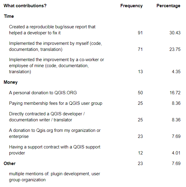
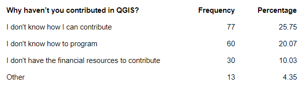
- What content will be kept
- What will be removed
- What is new to be added
- Keep front page as starting point
- Suggest tweaks if needed
- Establish a clear vocabulary of page types
- Second and third level page design
- Special pages such as
- Download
- Release countdown
- Donation / sustaining members
- Gallery
- and any other you identify as non-standard second/third level
- Guidance and standards for producing visuals like screenshots etc. For example, how we present QGIS screenshots in a flattering way.
- Establish a plan for auxiliary sites:
- Plugins.qgis.org
- Api.qgis.org
- Docs.qgis.org
- etc. (see intro for more exhaustive list)
- Iterative review and feedback from the QGIS web team should be incorporated from biweekly check in calls.
 Outcome: We have a clear roadmap and design guide for migrating all of our websites to a consistent unified experience.
Phase 2⃣: Content migration of the main site
During this phase the contractor will focus on migrating the content of the main site to the new platform.
There will be an iterative review and feedback from the QGIS web team should be incorporated from biweekly check-in calls.
Outcome: https://qgis.org new site goes live! (Target date end of February 2024)
Phase 3⃣: Auxiliary sites migrations
This is out of scope of the current call for proposals but should be part of the overall planning process:
This would be a collaborative process involving a QGIS funded web developer and the consultant.
Iterative review and feedback from the QGIS web team should be incorporated from biweekly check in calls.
Outcome: Auxiliary sites goes live with a cohesive look and feel to match the main site.
 What we will provide
- Maps and screenshots, videos, animations (with inputs from design team)
- Inputs in terms of content review
 Qualification criteria
 Must have an established track record of website design and content creation.
Individuals or companies equally welcome to apply.
Any potential conflict of interest should be declared in your application.
Discussions will happen in English, with live discussions as well as written communication via issues or Pull request. Being reasonably fluent in English and understand the soft skills required to interact in a community project will be more than appreciated
 Payment milestones
10 % Kick off
40 % Phase 1 Completion
50 % Phase 2 Completion
 Indicative budget
We would like to point you to the QGIS Annual Budget so that you have a sense of our broad financial means (i.e. we will not be able to afford proposals in excess of €25,000 for phase 1+2).
https://www.qgis.org/en/site/getinvolved/governance/annual_reports/index.html
 Technology choices and IP:
- Must be wholly based on Open Source tooling (e.g. javascript, css, web frameworks)
- Needs to be ideally implemented in Hugo (or Sphinx)
- Must produce a static web site (except for existing django based sites)
- Publication and development workflow will follow standard pull request / review process via our GitHub repositories
- Mobile friendly
- Site will be english only – any auto-translation tooling that can be added so that users can trivially see an auto-translated version of the site will be considered favourably.

 Proposal submission
Your proposal should consist of no more than 5 pages (include links to relevant annexes if needed) covering the following:
- Overview of yourself / your organization
- Delivery timeline
- Team composition
- Budget for each phase
- Examples of prior work
- Bonus things to mention if relevant: GIS experience & working with Open Source projects
Please send your proposal to [email protected] by October 29nd 2023 midnight, anywhere on earth.


 QGIS 3.4 has recently become our new Long Term Release (LTR) version. This is a major step in our history – a long term release version based on the massive updates, library upgrades and improvements that we carried out in the course of the 2.x to 3x upgrade cycle.