QGIS Planet

QGIS server 3.28 is officially OGC compliant

QGIS Server provides numerous services like WMS, WFS, WCS, WMTS and OGC API for Features. These last years, a lot of efforts were made to offer a robust implementation of the WMS 1.3.0 specification.

We are pleased to announce that QGIS Server LTR 3.28 is now certified against WMS 1.3.0.

This formal OGC certification process is performed once a year, specifically for the Long Term Release versions. But, as every change in QGIS source code is now tested against the formal OGC test suites (using OGC TeamEngine) to avoid any kind of regressions, you can always check any revision of the code against OGC failures in our Github continuous integration results.

All this has been possible thanks to the QGIS’s sustaining members and contributors.

QGIS Server and OGC API Features

Based on text and information from Paul Blottiere and Alessandro Pasotti (both QCooperative)

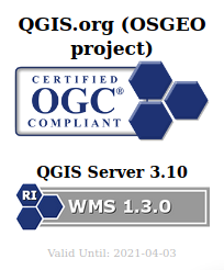
QGIS Server implements a number of OGC services, such as WMS, WFS, WCS or WMTS and extends these services where useful. Thanks to the efforts of a number of QGIS Server developers and companies, QGIS 3.10 (and 3.4 before) had been certified by the OGC for the WMS 1.3.0 service, and is also a WMS reference implementation.

alt wording

Last year in 2019, a new protocol has been developed and named OGC API Features (commonly known as WFS3). With the purpose of having an up-to-date QGIS Server, both OSGeo and QGIS.ORG have dedicated funds to work on the implementation of this brand-new service: but we wanted to do it right, so the ambition was also to reach the OGC certification!

This new protocol with REST interfaces gets rid of the XML specification to use the OpenAPI standard as well as the JSON open format instead. In other words, it’s not just another protocol to support, but a whole package of changes and fresh mechanisms to work on. It was quite a challenge!

QGIS core developers of QCooperative were remotely participating in OGC sprints to closely monitor the development of the new OGC API Features protocol. Hence, we started its implementation and a fully operational version landed in QGIS Server 3.10.

Implementation and features

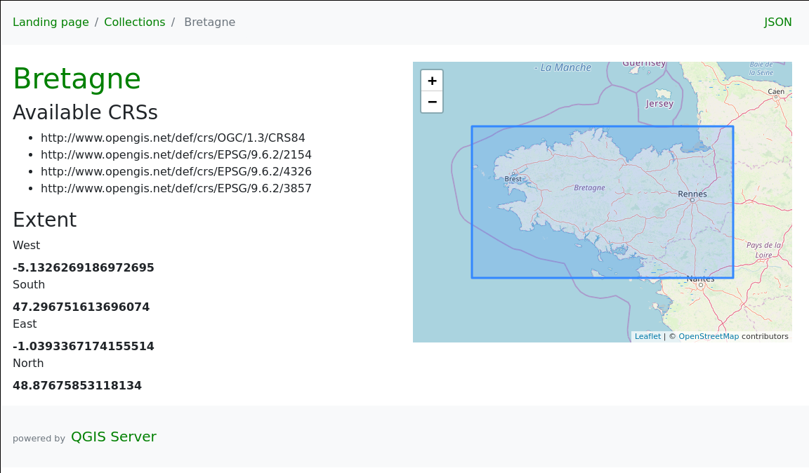
As a reminder, the WFS protocol allows to query, retrieve and manipulate vector features, unlike the WMS format which provides raster outputs. OGC API Features is the natural continuity and consistently provides basic mechanisms to retrieve features and corresponding information in a specific area (the famous GetFeatureInfo request in WFS 1.X).

In addition, QGIS Server also provides transactions for the OGC API Features protocol. This means basically that we can update, insert or delete features in the underlying data. And of course, everything can be easily reached and configured through QGIS Desktop.

Yet another interesting thing to note is also the full support of the date and time filtering. Nifty!

And last, but not least, QGIS Server 3.10 provides a default HTML template with an embedded map to explore the data served by the server. There’s literally nothing to configure, it’s just there as soon as you work with the OGC API Features protocol :).

alt wording

OGC Certification

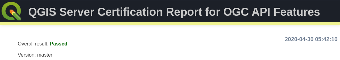
Once the implementation was completed, we started to address the OGC certification goal. To avoid unwanted regressions along the way, we first added nightly tests by updating the dedicated QGIS repository for OGC tests. From that moment, HTML reports are available day-to-day to monitor development over time.

Then, some bugfixes and backports later, we’re finally there: OGC tests are green on the development version, 3.12 and 3.10 releases. Yippee!

alt wording

Conclusion

Now that everything is in order, the last step is to start the formal OGC certification process. From now on, the dedicated QGIS OGC Team takes care of further operations.

QGIS Server is ready for the new OGC API for Features protocol.

The new OGC API for Features (OAPIF) (also formerly known as WFS3) is one of the first protocols of the new generation of OGC web services and we are happy to announce that QGIS Server is ready to serve data following the specifications of this new protocol.

A lot of work has been going on during last summer to make sure QGIS Server was ready to support the new family of REST APIs, the underlying architecture allows in fact to expand QGIS Server API capabilities with any kind of new API that will be available in the future.

The new API is very similar to the well known WFS, but it also comes with a distinct set of features like content negotiations, REST actions, HTML templates, JSON as a first class citizen, self-documentation of the API (following OpenAPI specifications) and a preliminary implementation (the specifications are not yet finalized) of the simple transactions.

The new API is already in the QGIS Server documentation, it only misses the transaction part because the specifications are not yet final and we don’t want people start relying on an API that is probably going to change quite soon.

The vast majority of this new development has been possible thanks to the volunteer work of our core developers but we also wish to thank OSGeo and QGIS sustaining members and donors for funding a substantial part of the following activities:

OPENAPI validation (completed)
Online demo (TODO)
CI validation/ OGC CITE (started)
Expose Schema (completed)
Simple Transactions (completed)
Returned fields filter (completed)
Documentation (completed except for transactions)
JSON performance comparison with WFS (TODO)
Time filter support (completed)

Enjoy the new API and beware that this is only the first of a brand new series of OGC APIs that will make much easier for users to interact with data and for developers to create applications that consume those data.

Text provided by Alessandro Pasotti (QGIS core developer)

QGIS Server 3.4.6 certified for WMS 1.3

We are very happy to announce that QGIS 3.4.6 LTR is now OGC certified as a reference implementation : qgis_server_ogc_badge_2019

The OGC certification program gives a third party validation that the a web service is compliant with the standard.

The certification process requires manual work, so we will only certify on version for each LTR.  This was not enough, so we build a OGC CI test platform that is checking compliance every night for WMS and WFS, so that you can check by yourself any specific version commit.

However WMS 1.3 is only the basics, if you rely on other services like WFS, WCS, or advanced capabilities like Raster or Vector Elevation, we are looking for supporters!

As the future is almost now If you want QGIS to be on the cutting edge with the upcoming WFS3, a JSON-REST modern version of WFS, please get in touch. We’d love to push this both into QGIS server and Desktop.

QGIS Server certified as official OGC reference implementation

We are very excited to announce that QGIS Server has been successfully certified as a compliant WMS 1.3 server against the OGC certification platform, and moreover, it is even considered as a reference implementation now!

This is the first step on our roadmap of having a fast, compliant and bullet proof web map server that is straightforward to publish from a classical QGIS project.

What does it mean?

Having a certified server means that QGIS Server successfully passes the automated and semi automated tests that ensure we are 100% compliant with the standards. That means you can trust QGIS to be used by any WMS client seamlessly.
Moreover, that certification is now powered by a continuous integration system that checks every night in developement versions if we still pass the tests.

Daily compliance reports are available on the new test.qgis.org website.

What’s next?

Building the automated testing platform and getting officially certified was only the first step. We now are starting to certify the WFS services, thanks to the latest grant application program support.

We also want QGIS server development to be performance-driven. The following projects are particularly relevant:

  • MS-Perf produces benchmark reports with MapServer and GeoServer.
  • graffiti  and PerfSuite tools have been designed to create a really light tool, easy to enrich with new datasets and performance tests, and easy to integrate in continuous integration systems. It compares QGIS-ltr, QGIS-rel and QGIS-dev nightlies for the same scenarios in details and produces html reports. It can also graph performance history for the development version to track regressions or improvements.

Many thanks to the supporters and voting members that helped bootstrap all those testing platforms and offer them to the community.

If you want to support or give a hand on the QGIS desktop client side, we think that area would deserve some love too!

QGIS Server refactoring is done!

As you may know, QGIS is jumping to a new major version. (Yes!) Doing so was made necessary because of the need to switch to Python 3, Qt5, but also because we needed to break the QGIS API in several places.

A year ago there was an appeal on the QGIS developer mailing list about the strong need for love that the QGIS server code base required. Indeed, the API was locked by some old methods of QGIS server. In short, QGIS server was reparsing the .qgs project file in its own way, and created dependencies to parts of QGIS we needed to drop.

As outsourcing the server code base was not an option, so we had to refactor it. The involved parties decided to get engaged in a code sprint in the city of Lyon , France dedicated to sharing their vision, planning the work and finally making all the following happen:

Higher level refactoring

All services (WMS GetMap, WFS GetFeature, GetLegendGraphics, WCS, GetPrint etc..) have been rewritten. Some like WMS were entirely rewritten. Kudos to the devs!

New features

Deep, complex and unrewarding tasks

  • Remove all singleton calls
  • Cut all the dependencies to the old QGIS project file parser
  • Minimize dependencies to GUI library. Since fonts are necessary to render maps, totally removing them was not feasible.

Infrastructure tasks

Additionally, some of these new developments have already been presented at FOSS4G-EU in July.

Congratulations to the developers who worked hard on this!

Now this deserves to be well tested, please report back any issues!

Back to Top

Sustaining Members