QGIS Planet

User question of the Month – Sep’19

After the summer break, we’re back with a new user question.

This month, we want to focus on documentation. Specifically, we’d like to know how you learn how to use QGIS.

The survey is available in English, Spanish, Portuguese, French, Ukrainian, and Indonesian. If you want to help us translate user questions into more languages, please get in touch on the community mailing list!

Introducing new QGIS macOS packages

We now have signed packages for macOS. You can find these packages published on the official QGIS download page at http://download.qgis.org.

Rationale

In addition to being a very powerful and user-friendly open source GIS application, QGIS can be installed on different operating systems: MS Windows, macOS, various flavours of Linux and FreeBSD. 

Volunteers help with generating the installers for those platforms. The work is highly valuable and the scale of effort put into packaging over the years is often underappreciated. QGIS has also grown significantly over the years and so has its complexity to package relevant libraries and 3rd party tools to the end-users.

QGIS has been packaged on OSX/macOS for many years, making it one of the few GIS applications you can use on this platform. This is largely thanks to the tireless work of William Kyngesburye (https://www.kyngchaos.com/software/qgis/) who has shouldered the task of compiling QGIS and its dependencies and offering them as disk images on the official QGIS website. The packages for each new release are available within days for all supported macOS versions.

Unlike most other operating systems, macOS can only be run on Apple hardware. This is a barrier for developers on other platforms who wish to compile and test their code on macOS. For other platforms, QGIS developers have automated packaging, not only for the major releases but also for daily code snapshots (aka nightly or master builds). Availability of the daily packages has allowed testers to identify platform-specific issues, well before the official release.

Apple also has a system of software signing so that users can verify if the packages are securely generated and signed by the developers. Up until now, signed macOS packages were not available, resulting in users who are installing QGIS needing to go into their security preferences and manually allow the QGIS application to be run. 

A new approach

In October 2018, Lutra Consulting started their work on packaging QGIS for macOS. The work has been based on OSGeo tap on Homebrew. Homebrew is a ‘bleeding edge’ package manager similar to those provided by Gentoo or Arch Linux. The packages by Lutra bundle the various libraries and resources on which QGIS depends into a single QGIS.app application bundle.  The packages were made available in late 2018 for QGIS official releases and master. QGIS Mac users have eagerly tested and reported various issues and the majority of them were resolved in early 2019.

Following the successful launch of the prototype packages and in discussion with other developers, it was agreed to transfer the ownership of the packaging infrastructure and scripts (https://github.com/qgis/QGIS-Mac-Packager) to QGIS.org. Using the new infrastructure and OSGeo Apple developers certificate, all QGIS ‘disk images’ (installers) have been available since late May 2019.

What are the main difference between the new installers and the ones offered by Kyngchaos? The new installer offers:

  • 3 clicks to install: download, accept Terms & Conditionss, drop to /Application
  • All dependencies (Python, GDAL, etc)  are bundled within the disk image
  • Signed by OSGeo Apple certificate
  • Availability of nightly builds (master)
  • Scripts for bundling and packaging are available on a public repository
  • Possibility of installing multiple versions (e.g. 3.4 LTR, 3.8 and master) side-by-side

There are some known issues:

For a full list, see: https://github.com/qgis/QGIS-Mac-Packager

Further work

We hope that by providing the new installers, macOS users will have a better experience in installing and using QGIS. Ideally, with the availability of nightly builds and being more accessible to new users, more software bugs and issues will be reported and this will help to improve QGIS overall.

Maintaining and supporting macOS costs more compared with other platforms. As QGIS is one of the only viable GIS applications for macOS users in an enterprise environment, we encourage you and your organisation to become a sustaining member to help assure the continued availability and improvement of the macOS packages in the long term.

Future plans

In future we plan to migrate the packaging process to use Anaconda QGIS packages as the source for package binaries. We also would like to integrate macOS builds into the Travis-CI automated testing that happens whenever a new GitHub pull request is submitted so that we can validate that the macOS packages do not get any regressions when new features are introduced.

Conclusion

With this work, we now have nightly builds of the upcoming release (‘master’) branch available for all to use on macOS. We now have signed packages and we have an automated build infrastructure that will help to ensure that macOS users always have ready access to new versions of QGIS as they become available. You can find these packages published on the official QGIS download page at http://download.qgis.org. A huge thanks to the team at Lutra Consulting for taking this much-needed work, and to William Kyngesburye for the many years that he has contributed towards the macOS/OSX QGIS packaging effort!


QGIS 3.8 Zanzibar is released!

We are pleased to announce the release of QGIS 3.8 ‘Zanzibar’! Zanzibar was the location of our developer meeting before the international FOSS4G 2018 conference in Dar Es Salaam.


Installers for all supported operating systems are already out. QGIS 3.8 comes with tons of new features, as you can see in our visual changelog.

We would like to thank the developers, documenters, testers and all the many folks out there who volunteer their time and effort (or fund people to do so). From the QGIS community we hope you enjoy this release! If you wish to donate time, money or otherwise get involved in making QGIS more awesome, please wander along to qgis.org and lend a hand!

QGIS is supported by donors and sustaining members. A current list of donors who have made financial contributions large and small to the project can be seen on our donors list. If you would like to become a sustaining member, please visit our page for sustaining members for details. Your support helps us fund our six monthly developer meetings, maintain project infrastructure and fund bug fixing efforts.

QGIS is Free software and you are under no obligation to pay anything to use it – in fact we want to encourage people far and wide to use it regardless of what your financial or social status is – we believe empowering people with spatial decision making tools will result in a better society for all of humanity.

QGIS Grant Programme 2019 Results

We are extremely pleased to announce the winning proposals for our 2019 QGIS.ORG grant programme. Funding for the programme was sourced by you, our project donors and sponsorsNote: For more context surrounding our grant programme, please see: QGIS Grants #4: Call for Grant Proposals 2019.

The QGIS.ORG Grant Programme aims to support work from our community that would typically not be funded by client/contractor agreements. For the first time, this year we did not accept proposals for the development of new features. Instead proposals should focus on infrastructure improvements and polishing of existing features.

Voting to select the successful projects was carried out by our QGIS Voting Members. Each voting member was allowed to select up to 6 of the 10 submitted proposals by means of a ranked selection form. The full list of votes are available here (on the first sheet). The second sheet contains the calculations used to determine the winner (for full transparency). The table below summarizes the voting tallies for the proposals:

A couple of extra notes about the voting process:

  • The PSC has an ongoing program to fund documentation so elected to fund the proposal “Open documentation issues for pull requests” even if this increases the total funded amount beyond the initial budget.
  • Although the budget for the grant programme was €20,000, the total amount for the winning proposals is €22,200. This increase is possible thanks to the generous support by our donors and sponsors this year.
  • Voting was carried out based on the technical merits of the proposals and the competency of the applicants to execute on these proposals.
  • No restrictions were in place in terms of how many proposals could be submitted per person / organization, or how many proposals could be awarded to each proposing person / organization.
  • Voting was ‘blind’ (voters could not see the existing votes that had been placed).

We received 31 votes from 16 community representatives and 15 user group representatives.

On behalf of the QGIS.ORG project, I would like to thank everyone who submitted proposals for this call!

A number of interesting and useful proposal didn’t make it because of our limited budget; we encourage organizations to pick up one of their choice and sponsor it.

Videos from A Coruña

We’re glad to announce that the recorded presentations from our user conference in A Coruña are now available online on the TIB AV-Portal.

Enjoy and thanks to all participants, sponsors and organizers!

qgisuserconf2019


QGIS Server 3.4.6 certified for WMS 1.3

We are very happy to announce that QGIS 3.4.6 LTR is now OGC certified as a reference implementation : qgis_server_ogc_badge_2019

The OGC certification program gives a third party validation that the a web service is compliant with the standard.

The certification process requires manual work, so we will only certify on version for each LTR.  This was not enough, so we build a OGC CI test platform that is checking compliance every night for WMS and WFS, so that you can check by yourself any specific version commit.

However WMS 1.3 is only the basics, if you rely on other services like WFS, WCS, or advanced capabilities like Raster or Vector Elevation, we are looking for supporters!

As the future is almost now If you want QGIS to be on the cutting edge with the upcoming WFS3, a JSON-REST modern version of WFS, please get in touch. We’d love to push this both into QGIS server and Desktop.

Crowdfunding initiatives in spring 2019

Currently there are a number of ongoing crowdfunding initiatives for improvements in QGIS that need your support:

1. Diagrams in print layouts, atlas and reports: the popular data plotly plugin for interactive, exploratory charts and diagrams should be enhanced to support embedding in print layouts, atlas serial prints and reports. Details can be found at the North Road campaign website. This is a joint effort of companies Faunalia and North Road. Funding goal: € 8’600 (1’780 collected as of April 2, 2019)

2. Cartography proposal: selective masking of symbol levels behind labels and map symbols. Inspired by the high-quality topographic maps of Swisstopo. Details can be found at the Oslandia campaign website. Funding goal: € 20’000 (8’000 collected as of April 2, 2019)

3. GeoPDF-Export: Export of georeferenced PDF files, with the possibility to measure, query coordinates, toggle map layers and query feature attributes. The project is partitioned into several work packages. This is a joint effort of Even Rouault and North Road on request of several Austrian local government agencies. For more details, please contact Johannes Kanonier of the Landesvermessungsamt Vorarlberg. Funding goal: € 30’800 (24’400 collected as of April 2, 2019)

4. SLYR: Converter for ESRI LYR and MXD-Files. Project is partitioned in several work packages for the conversion of ESRI styles to QGIS styles, MXD-Files into QGIS project files and ESRI layouts to QGIS layouts. Please find more details at the SLYR website of North Road.

Thank you for your support in making these projects a reality!

QGIS 3.6 Noosa is released!

We are pleased to announce the release of QGIS 3.6 ‘Noosa’! Noosa was the location of a local Australian developer meeting in autumn 2017.

Installers for all supported operating systems are already out. QGIS 3.6 comes with tons of new features, as you can see in our visual changelog.

We would like to thank the developers, documenters, testers and all the many folks out there who volunteer their time and effort (or fund people to do so). From the QGIS community we hope you enjoy this release! If you wish to donate time, money or otherwise get involved in making QGIS more awesome, please wander along to qgis.org and lend a hand!

QGIS is supported by donors and sustaining members. A current list of donors who have made financial contributions large and small to the project can be seen on our donors list. If you would like to become a sustaining member, please visit our page for sustaining members for details. Your support helps us fund our six monthly developer meetings, maintain project infrastructure and fund bug fixing efforts.

QGIS is Free software and you are under no obligation to pay anything to use it – in fact we want to encourage people far and wide to use it regardless of what your financial or social status is – we believe empowering people with spatial decision making tools will result in a better society for all of humanity.

A Coruña contributors meeting: another step forward for the QGIS.ORG project!

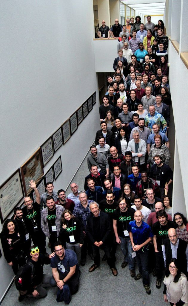
IMG_20190310_101428_486~2

On behalf of QGIS.ORG and the whole community, I’m would like to extend our thanks and congratulations to all the local volunteers who helped to make the event happen, with special thanks to Luigi “Ginetto” Pirelli, who spearheaded the effort. The event, which included a full week of workshops, a user conference, and contributor meeting, marked another milestone in the history of QGIS.

It was possibly the largest meeting we have had to date. It especially gratifying seeing more diversity and new faces. Our inclusive and welcoming community has always been a point of pride and it was amazing seeing how newcomers easily and pleasantly integrating in the community, producing good and tangible results within just a few days.

Many decisions were made, many discussions were fruitfully concluded, many tortillas were eaten, plans were laid out. These events are critical for preparing the way for the future of the QGIS.ORG project.

Our heartfelt thanks to all who donated their time and intellect, and to the many donors and sponsors to make all this possible.

See you in Bucharest next August, for the 23rd QGIS meeting!

QGIS.ORG

End of life notice: QGIS 2.18 LTR

257901067_158842QGIS 3.4 has recently become our new Long Term Release  (LTR) version. This is a major step in our history – a long term release version based on the massive updates, library upgrades and improvements that we carried out in the course of the 2.x to 3x upgrade cycle.

We strongly encourage all users who are currently using QGIS 2.18 LTR  as their preferred QGIS release to migrate to QGIS 3.4. This new LTR version will receive regular bugfixes for at least one year. It also includes hundreds of new functions, usability improvements, bugfixes, and other goodies. See the relevant changelogs for a good sampling of all the new features that have gone into version 3.4

Most plugins have been either migrated or incorporated into the core QGIS code base.

We strongly discourage the continued use of QGIS 2.18 LTR as it is now officially unsupported, which means we’ll not provide any bug fix releases for it.

You should also note that we intend to close all bug tickets referring to the now obsolete LTR version. Original reporters will receive a notification of the ticket closure and are encouraged to check whether the issue persists in the new LTR, in which case they should reopen the ticket.

If you would like to better understand the QGIS release roadmap, check out our roadmap page! It outlines the schedule for upcoming releases and will help you plan your deployment of QGIS into an operational environment.

The development of QGIS 3.4 LTR has been made possible by the work of hundreds of volunteers, by the investments of companies, professionals, and administrations, and by continuous donations and financial support from many of you. We sincerely thank you all and encourage you to collaborate and support the project even more, for the long term improvement and sustainability of the QGIS project.

QGIS Grants #4: Call for Grant Proposals 2019

Dear QGIS Community

Our first three rounds of Grant Proposals were a great success. We are very pleased to announce the fourth round of grants is now available to QGIS contributors.

Based on community feedback, this year, we will not accept proposals for the development of new features. Instead proposals should focus on infrastructure improvements and polishing of existing features.

The deadline for this round is Sunday, 2 June 2019. All the details for the grants are described in the application form, and for more context we encourage you to also read last year’s articles:

We look forward to seeing all your great ideas about how to improve QGIS!

Anita Graser

QGIS PSC

User question of the Month – Feb’19 & answers from Jan

In January, we wanted to learn more about if and how QGIS users contribute back to the project. We received 299 responses from all over the world:

user_survey_january_map

55% of responders have contributed to the project in the past:

user_survey_january_1

Responders who stated that they had contributed to QGIS were asked to specify what kind of contributions they had provided. This question was multiple-choice. Time contributions are generally more common than financial contributions. 30% of responders helped by creating reproducible bug reports and 24% implemented improvements themselves. The most common financial contribution are personal donations to QGIS.ORG at 17%.

Membership in user groups, contracting developers / documentation writers / translators, or having a support contract with a QGIS support provider are less common amongst responders:

user_survey_january_2

Responders who stated that they had not contributed to QGIS most commonly stated that they didn’t know how to contribute (26%), while lacking financial resources were only raised by 10% of responders:

user_survey_january_3

New question

This month, we’d like to know which plugins you think should be advertised as “featured” on the official QGIS plugin repository.

The survey is available in English, Spanish, Portuguese, French, Italian, Ukrainian, Danish, and Japanese. If you want to help us translate user questions in more languages, please get in touch!

User question of the Month – Jan19 & answers from Dec

In December, we wanted to know what QGIS.ORG should focus on in 2019.

Portuguese 

selection_002

Based on these results, in today’s PSC meeting, we’ve decided that the 2019 grant programme will be focusing on bug fixing and polishing existing features. So thanks to everyone who provided feedback!

New question

This month, we’d like to know if you have ever contributed to improving QGIS and – if yes – how. As you’ll see, there are many different ways to contribute to QGIS, so please go ahead and take the survey.

The survey is available in English, Spanish, Portuguese, French, Italian, Ukrainian, and Danish. If you want to help us translate user questions in more languages, please get in touch!

User question of the Month – Dec 18 & answers from Nov

It’s December and that means it is time to plan for the next year. Planning also means preparing a budget and to do so, we would like to learn more about what you think QGIS.ORG should focus on: features or bug fixing and polishing? Therefore, we invite you to our QGIS user question of December 2018.

We also have localized translated versions of this questionnaire for our French-speaking and Portuguese-speaking users.

Your answers in November

In November, we wanted to know which version of QGIS you use.

Call for presentations: QGIS User Conference and Developer Meeting, 2019

The next International QGIS User Conference and Developer Meeting will take place in the week from 4 to 10 March 2019 in A Coruña (Spain).


coru
The call for presentations and workshop registration is out and you can apply using the online registration form. Note that the deadline for presenting proposals is 21 Dec 2018. If you need any info please email your queries to: [email protected]


The International QGIS User and Developer Conference wants to be the reference conference for the QGIS community, a meeting point for the family of users and developers associated with the QGIS project. Attending the conference is an opportunity to gather experience and share knowledge about QGIS. The language of the conference is English.


The event is organized by the Spanish QGIS Association [1], the Spanish user group, and the Galician Xeoinquedos community [2] with the help of A Coruña municipality [3]. The event is under the QGIS.org umbrella. We look forward to seeing you there!


Results of the MacOS bug fixing initiative

Thanks to your donations, we were able to hire core developers to focus on solving Mac OS specific issues for QGIS. More than 30 MacOS QGIS users donated a little more than 3000 € for this bug fixing round.

After an effort of triage and testing, here is what has been achieved:

Unfortunately, some issues remain. Mainly, the text being rendered as outlines in PDF export (https://issues.qgis.org/issues/3975) remains for now. It might be fixed in a following effort.

Thanks to all donors who helped in this effort and to Denis Rouzaud as a core developer who spent a lot of time investigating and fixing these issues!

User question of the Month – Nov 18

QGIS 2.18 is the third LTR since we started this effort back in 2015 and next year will see the first LTR of QGIS 3. On this occasion, we want to learn more about our users and which versions of QGIS they use. Therefore, we invite you to our QGIS user question of the month.

Report back on the 20th QGIS Hackfest in Zanzibar


This post summarizes personal reports of community members who attended the 20th Hackfest in Stone Town, Zanzibar the week before the FOSS4G in Dar Es Salaam.

Report from Matteo Ghetta

QGIS developers spent 3 days in the beautiful island of Zanzibar were they worked on bug fixing, improvement of new features and documentation enhancements. It is extremely important for developers to meet together and spend some days working side by side given that the geographical distribution is very wide.

Thanks to the (local government & Yves Barthelemy) we had the chance to visit the Land Mapping Commission in Stone Town: It has been an amazing experience for both developers and local council. Moreover developers visited the SUZA (University of Zanzibar) and saw the local infrastructure and GIS related workflow.

  • I have merged many PR of the documentation
  • Many old and not old issues have been closed or the author has been pinged
  • Many new additions to the documentation both small corrections and new sections from scratch
  • A new version of DataPlotly released
  • A small presentation of DataPlotly to the QGIS crew

Report from Mario Baranzini

I spent one day of the Hackfest contributing to the SLYR project, improving the conversion of LAB colors. SLYR (https://github.com/nyalldawson/slyr) is a project started and almost entirely developed by Nyall (which was not present to the Hackfest) which aims to provide tools to extract and convert symbols from ESRI .lyr and .style files and use them in QGIS. Nyall has recently worked hard on the project and perhaps soon sponsorship will allow further development.

Around this theme there is a keen interest. Even during the FOSS4G there has been discussion of the conversion of ESRI symbols and there was also a presentation of how the conversion in Israel is currently managed.

During the rest of the hackfest, I worked on the implementation of the new QField file selector.

Report from Denis Rouzaud

Report from Tim Sutton

Firstly let me thank the QGIS project for contributing to my travel and accommodation costs – I am most grateful for the support! This hackfest was special for me because it is the first hackfest in an African country. As an African born person living in the interface between “first world” and “third world”, I have always had a particular social agenda with QGIS: To bring spatial tools to support responsible and sustainable management of our world. There is a huge technological and skills divide between Europe and less developed societies where QGIS can be a valuable social enabler in helping to advance the standard of living and quality of life. Hosting a hackfest in an environment where we don’t have tree cadastres, street furniture cadastres and every aspect of civilian life mapped and systematised is an important way to build empathy and understanding in our QGIS core community members for a broader cross-section of our user base. Having the opportunity to meet with users from ZMI (the Zanzibar Mapping Initiative) and students from the local university was a really uplifting experience. ZMI are building the national cadastre from the ground up using QGIS, PostGIS and UAV mapping. We were privileged to have a number of Zanzibar residents join us on the hackfest and get to experience just how appreciative they are, first hand.

There were a number of interesting topics that arose during the hackfest which I will try to summarise here:

Certification:

We held an extended meeting on the QGIS Certification Programme, mainly detailing how we should go about the review process for onboarding new organisations.

Mac OS Build:

I spent quite a bit of time struggling with my MacOS build on QGIS. It’s definitely an area of the project that needs more work as the process can be non-trivial and the brew based formulas quickly become outdated.

QField Show and Tell:

Matthias showed off the latest version of QField and all the hard work they have been putting into the QGIS mobile client. This Android based version of QGIS for mobile data gathering is a really great project and is getting more and more useful with each release. There was also a translation sprint for QField during which I translated it to Afrikaans.

QField Autobuilds:

Denis and Matthias showed off the work they have done to automate the .apk builds for QField. Their system combines Travis and some git hooks to automatically build .APK’s whenever a pull request os made or a tag is made. See the QField travis for details: https://github.com/opengisch/QField/blob/master/.travis.yml

Plotly plugin:

Matteo Ghetta showed off the latest capabilities of the Data Plotly plugin for QGIS 3. The plugin supports the creation of a wide assortment of charts from your layer’s attribute data. See the plugin homepage here for examples and more detail: https://github.com/ghtmtt/DataPlotly 

Governance:

I took the opportunity to sign off the statute changes from 2017 general meeting. This was my last official act as outgoing project Chair. I was also extremely humbled to be awarded an Honorary PSC membership during the FOSS4G2018 conference.

TimRecievesHonoraryPSCMembership
Easter Eggs:

I contributed a couple of new easter eggs to QGIS. While easter eggs are fun, the data behind these hidden tools provide an important history of the project. I took the opportunity of having many long-time QGIS community members around the dinner table to collate all the previous QGIS meet-up dates. You can view this as a map here: https://github.com/qgis/QGIS/blob/master/resources/data/qgis-hackfests.json 

The spatial clustering of these events shows that going to Zanzibar and getting out of our geographical comfort zone is a really useful endeavour.

Report from Paolo Cavallini

During the HF in Zanzibar I mainly worked on:

  • Plugins: I cleaned up the queue of unapproved plugins, contacting all individual authors, fixing what was possible and deprecating the worst cases; we also solved a long standing issue with a contentious plugin
  • Issues: I examined many tickets, especially those waiting for feedback
  • Training certification: through a very productive meeting we defined clear rules for accepting certifying organizations, with the main aim of driving people to actively support the project:
    • in the application process, the proponent should explain what are his contribution to QGIS project
    • following an initial review, the application will be sent to local QGIS groups for their opinion, which should take place in less than one monthly; where there is no user group, the responsibility will fall entirely on PSC shoulders
    • the training material for each course should be released with a free license, and a review will be done; if the material is not of adequate quality, this is a cause for refusal
    • then PSC will take a decision and publish the contributions as stated by the proponent, for transparency
  • Other meetings helped focusing on our mission, defining the relationship between volunteer and paid work, and other
  • I visited the Land Mapping Commission and the University, soliciting a tighter cooperation with QGIS project.

Report from Admire Nyakudya

During the heck fest in Zanzibar, I mainly worked on porting some common plugin we use to QGIS 3. The plugins I mainly worked on were Cogo Parcel plugin and Sg Diagram downloader. We visited the Zanzibar mapping agency and interacted with the people who were working on capturing cadastral data using QGIS and explained them about the COGO Parcel plugin which streamlines capturing cadastral boundaries in QGIS and storing the results in a PostgreSQL database. To summarise the work I was working on during the heck fest.

  • Port Cogo Plugin from QGIS 2 to make it compatible with QGIS 3. This has been achieved and now awaiting one of my team members to approve the pull request.
  • Expand functionality being offered by the COGO Parcel plugin to include the new reporting framework in QGIS 3.
  • Investigate ways to generate projects on the fly after talking to Matteo and seeing the work he has done with QGIS project generator.

I also went to the Zanzibar university to see ways in which QGIS is being used in the local university and how students are integrating drone imagery with QGIS.

Report from Matthias Kuhn

The highest value of hackfests is actually to meet and greet and discuss ideas and bigger plans. There is a lot of communication on a high bandwidth channel (also known as face-to-face) that strengthens the community. This helps to quickly overcome technical problems sometimes. Or to give someone some tips and tricks you normally wouldn’t come to (e.g. optimizing a git workflow) that results in a long-term gain because of sustainable productivity improvements. I tend to walk around once in a while and just randomly bump into people where I – more or less successfully – try to help them solve their issues or discuss approaches. In the same area, there is the possibility to informally discuss plans about organization, workflows and strategies. The concept of an LTR was to a big degree discussed and built at a hackfest in Essen some years ago. This year there was a very interesting discussion about the topic LTR. For how much time the “long” in the term “long term release” should stand, about the life cycle of releases and of long-term releases. One of the important things when it comes to this question is what organisations think and do – because, in the end, it is mostly for organisations that the LTR exists – and how development resources can be assigned to the task of keeping a high quality of an LTR during its whole lifetime. There are no conclusions yet, but synchronizing on these ideas is often the seed for tomorrow’s exciting changes.

We were also visited by a group of students from the local university. It was really refreshing to talk to them about open source and QGIS and how we work and what the challenges of spatial data and GIS infrastructure are on an island like Zanzibar.

Feature-wise, the main thing I worked on feature wise was a new snap to grid functionality that is available for digitizing tools. It allows configuring a precision for vector layers. Whenever a new node is added or an existing one is edited on this vector layer, it will be automatically placed on this grid. Normally this is used to force the objects on a layer to something like cm or mm resolution.

And then, of course, I did my daily bunch of (mostly volunteer) pull request reviewing, some code cleanup and some bugfixes.

Report from Marco Bernasocchi

https://photos.app.goo.gl/seX2kSJ9vKxKBZt58

The Zanzibar hackfest was a special one for me, my first hackfest as QGIS.org co-chair. My main goal was definitely to get as much information out of Tim as possible so that I wouldn’t have to keep on bugging him all time 🙂

Beside that, multiple meetings where planned to which I took part, as Paolo already explained, we had very good meetings about:

  • Certifications meeting
  • Trademark discussion
  • Creating a membership system that allows entities that are not allowed to budget sponsoring money to instead become paying members.
  • Other meetings helped focusing on our mission, defining the relationship between volunteer and paid work, and other

On the first two days, we were joined by a largish group of local students to whom I explained how the structure of QGIS.org works and where they could help. I also helped them choosing a task to work and mentored them.

As I mentioned before, I spent a lot of time asking a lot of questions to Tim to get the biggest possible knowledge transfer about running QGIS.org and some time choosing and booking restaurants for our evening “meetings”

On the technical side, I worked with Mario on a new implementation of the QField File selector.

After everybody left, the OPENGIS.ch team stayed one day longer and introduced Mario to the real Brighton-style hackfest with take-away pizza 😉


QGIS 3.4 Madeira is released!

We are pleased to announce the release of QGIS 3.4 ‘Madeira’! Madeira was the location of our developer meeting in February 2018.

Windows installers and Ubuntu/debian binaries are already out, and all the packagers are actively preparing packages for the other operating systems. We’ll keep you updated when different packages and installers become available.

QGIS 3.4 comes with tons of new features, as you can see in our visual changelog.

QGIS 3.4 will become the first LTR of version 3. Based on our current plans, 3.4 will replace 2.18 as LTR in February 2019.

We would like to thank the developers, documenters, testers and all the many folks out there who volunteer their time and effort (or fund people to do so). From the QGIS community we hope you enjoy this release! If you wish to donate time, money or otherwise get involved in making QGIS more awesome, please wander along to qgis.org and lend a hand!

QGIS is supported by donors and sponsors. A current list of donors who have made financial contributions large and small to the project can be seen on our donors list. If you would like to become and official project sponsor, please visit our sponsorship page for details. Sponsoring QGIS helps us to fund our six monthly developer meetings, maintain project infrastructure and fund bug fixing efforts. A complete list of current sponsors is provided below – our very great thank you to all of our sponsors!

QGIS is Free software and you are under no obligation to pay anything to use it – in fact we want to encourage people far and wide to use it regardless of what your financial or social status is – we believe empowering people with spatial decision making tools will result in a better society for all of humanity.

MacOS specific bug fixing campaign

If you are a MacOS QGIS user, you are probably bothered by some MacOS specific bugs. These are due to the fact that we have fewer QGIS developers working on the MacOS platform and there are additional MacOS specific issues in the underlying qt5 library.

Nevertheless, we found a developer, Denis Rouzaud, who wants to specifically look into investigating and hopefully solving several of these issues. If you are a MacOS user and care about a better QGIS experience on this platform, we invite you to financially support this effort. As a private person, and for smaller amounts, please use the usual donation channel – if you are a company or organization and want to contribute to this specific effort, please consider becoming a sponsor. In any case – please add “MacOS bug fixing campaign” as a remark when donating/sponsoring or inform [email protected] about your earmarked donation.

This effort runs from the 14th September 2018 until the 3.4 release date, due on October 26, 2018. See the QGIS road map for more details about our release schedule.

Specific issues that are looked into, are:

issue priority subject
11103 1 Support for retina displays (HiDPI)
17773 1 No Retina / HiDPI support in 2.99 on osx
19546 1 QGIS 3 slow on macOS at high resolutions
19524 1 [macOS] Map canvas with wrong size on QGIS 3.2.1 start up
19321 2 Map Tips on Mac doesn’t display the content correctly
19314 1 3.2 crashes on startup on a Mac
19092 2 Measure tool on a Mac uses the top right corner of the cross hair cursor instead of the centre
18943 3 QGIS Server on MacOS X High Sierra
18914 3 [macOS] Plugin list corrupted by wrongly placed checkboxes on Mac
18720 2 QGIS 3.0.1 crashes on Mac
18452 3 Snapping options missing on Mac
18418 2 Scroll zoom erratic on Mac trackpad
16575 3 QGIS 2.18.7 crashes on macOS 10.12.4 when undocking the label panel
16025 2 [macOS] Control feature rendering order will crash QGIS
3975 2 PDF exports on OSX always convert text to outlines

Thank you for considering to support this effort! Please note that some issues may also exist due to up-stream issues in the qt library. In such a case, it can’t be guaranteed if and how fast, such an issue can be fixed.

Andreas Neumann, QGIS.ORG treasurer

Back to Top

Sustaining Members