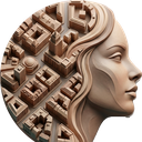
02UrbanPortrait - City as a Face
Draw a portrait with a city's own streets and buildings: line weights and colours follow a photo's light and dark, live on the map, exported to PNG, PDF or SVG for print.
02UrbanPortrait turns a street network into a picture. Load a photo, place it over an area, and roads, buildings and points take their stroke width, size or colour from the brightness beneath them; from a distance the city becomes a face, a landmark or a logo. Your source geometry and attributes are never changed.
Download streets and buildings for the area in one step or use project layers. Choose engraving, halftone (square or hex) or mask styles, start from ten colourways or your own JSON preset, and see the portrait update as you pan and zoom. The portrait is saved with the project and exports as PNG, PDF or SVG for posters and print.
Manual: https://geophilo.com/zero2urbanportrait/manual.html