
agknow for QGIS
Plugin ID: 1584
Plugin for using the ag|knowledge REST API from <a href="https://geocledian.com">geo|cledian</a>
(32) votes
Download latest
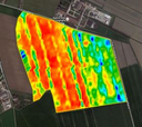
This plugin allows the usage of the remote sensing API ag|knowledge from geo|cledian.com. The API provides a field monitoring service that allows to monitor any agricultural field worldwide with a variety of vegetation indexes, crop parameters, times series analysis and comparison features based on satellite data.<p> Features of the plugin include the download and analysis of time series of visible and vegetation indexes rasters of registered fields. The data is based on Landsat-8 and Sentinel-2 currently. See <a href="https://docs.geocledian.com">https://docs.geocledian.com</a> for a detailed product overview.<p> Please note that you will need a registered API key from geocledian.com to use this plugin for your area of interest. The plugin is delivered with a demo key that allows to access some demo parcels around the world for evaluation purposes.


