QGIS Planet

Notes from the QGIS-UK South West user group

Yesterday Dartmoor National Park was host to the third QGIS user group for the South West region. We a great range of talks from the worlds of academia, offshore exploration and local government to name but a few. The slides from these are below.

Teaching in QGIS

Using PostGIS within our Geospatial Workflows at Lloyd’s Register

The Adoption of QGIS at Plymouth Community Homes

Integrating QGIS functionality into a data workflow through both automated processing and a plugin

PopChange: An Academic Open Source Project

Building a Mixed GIS Environment at the Met Office

We are looking at having another meet up in the spring and are thinking of running some workshops on form designing and plugin building. Keep an eye on the main QGIS user group page on Google+ for any news.

Thanks again to everyone who attending and presented.  We also need to give a special thanks to Clear Mapping Company for sponsoring the event.

Cheers

Matt

South-East QGIS User Group – Writeup

Since helping to organise the inaugural meeting in September 2013, this was the first UK QGIS South-East UG meeting which piggy-backs off the success of the Scottish and Welsh UG meetings.

Putting an agenda together isn’t the easiest thing to do at the best of times and especially given that the use of QGIS here in the UK is still in its infancy but thankfully without much need for pleading many kind people came together to help out and make the day a great success.

Imperial College hosted the event for us and everyone one agreed that the facilities were fantastic. A special thanks needs to go to Claudia Vitolo for arranging everything for us at Imperial. There was a good turnout with about 55 people turning up, with a real mix of public, private and academic backgrounds.

imperial_1

David McDermott started off proceedings with a talk about Atlas and Map Production. He cleanly illustrated to the audience through screenshots how Surrey Heath Borough Council are using this fantastic feature of 2.2 to produce lots of maps, quickly, efficiently and importantly eye-pleasing.

imperial_2

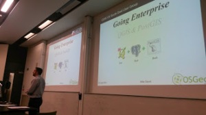
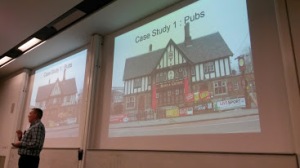
Mike Saunt demonstrated through a mixture of presentation and live demo a series of tweaks within QGIS and using a bit of SQL in PostGIS, how QGIS can be an Enterprise GIS tool. For those in the audience that new to QGIS or looking for alternative GIS solutions were keen to ask questions about the QGIS/PostGIS architecture which Mike was very happy to answer, sighting many case examples.

imperial_3

Jerry Clough gave a well received talk on OpenStreetMap and promoted a lot of conversation. Jerrys’ talk was a real mixed bag of factoids and tips on OSM in general and using it within QGIS.

Andrew Bell gave the audience a treat by demonstrating how with some simple PostGIS SQL you could within QGIS draw a line or route (from A to B) which would automatically buffer and select features from the Ordnance Survey PoI (Points of Interest) layer that fell within the buffer. All very simple but very effective process. Andrew admitted that this had a lot of scope and could be adapted for Emergency Planning for example.

View presentation here

The afternoon sessions saw two workshops;

Pete Wells from Lutra gave a whistle stop run through of using Python and QGIS, and went as far as producing a very simple plugin all within the space of an hour and ten minutes. It was a well attended talk and the sort of workshop that future user groups should try to repeat.

The Ordnance Survey did an Introduction to QGIS using OS Opendata and was equally well attended as Pete Wells workshop, as both workshops ran at the same time. The talk was loosely based on the successful OS MasterClasses that have been run over the past few years.

The schedule of the day quickly slipped, mainly due to the great audience participation at the end of the presentations. As a result the afternoon workshops, ‘its your floor’ and discussion sessions were shortened so that a 4pm finish was achievable.

Its your floor was a bit of a wild card slot in the days agenda. Prior to the event the attendees were asked  if they wanted to take to the stage and chat about what they were doing to QGIS, effectively 5 slides in 5 minutes. Two brave souls stepped upto the mark and gave informative but lightning talks about what they had been up to. This is certainly a part of the agenda that the South-East region will be repeating again.

The day ended with a lively debate about the role and future of the UK QGIS user group and it might be that moving forward such a debate becomes an earlier item on the days agenda.

One of the discussion points was on the cost of running future events. Based on an online poll conducted earlier on this year and feedback from the Scottish group, it was clear that for the group to continue future events will probably longer be free and as such a minimal donation would be required to attend. The true cost of hosting an event is probably more than most imagine. The single biggest cost is catering, in the case of this meeting and the inaugural meeting back in September 13, the combined cost just for catering was in excess of £1400. Luckily in both cases and in fact in all of the user group meetings that have occurred catering and venue hire costs have been met through sponsorship. However such kind support from private companies will not last indefinitely. The exact minimum donation cost may vary from event to event, depending on venue hire costs and catering.

Over a series of discussion topics a few themes kept on popping up which put into question the role of the user group. Behind the scenes of the user group, as with any user group or community there are also people busy working away to do all sorts of things in the background. The user group has a loose working community which is referred to as regional leads but in fact these regional leads are not standing alone but a few people supporting them. This working group has been discussing how we can work more closely with the core QGIS project and hopefully soon we will be able to clearly define how we achieve this. Where this thought process is going is that the role of the user group is just that, a user group and not a QGIS developer group. Clearly some people within the wider UK QGIS UG will be more developer minded than others and as such would be encouraged to participate the development of QGIS. Others may want to help out with updating manuals or bug hunting. While others might not be interested in any of the above and just want to create maps, data or GIS processes and share these with the group which should equally be encouraged.  We as a user group should be there to encourage any of the above users.

Simon Miles


Scottish QGIS User Group 19th March 2014

scottish thistleThe Scottish QGIS user group meeting is happening on 19th March 2014 in Stirling at the Stirling Management Centre.  Doors open at 9:30 with a 10:00 start and a planned finish of 16:00.  Registration is through Eventbrite and there are 50 places available working on a first come, first served basis.

Details on how to get to the Stirling Management Centre are available here.

The agenda will be published a bit closer to the time once speakers have been finalised.  If you would like to present let me (Ross McDonald) know as it would be good to have a mix of input to the day.  There are both 20 minute and “lightning talk” 5-10 minute slots available.

A big thank-you to thinkWhere for hosting this first QGIS user group event in Scotland.

If you want two days of geo discussion then think about attending the AGI Scotland – Future Cities event in Glasgow the day before.  Check the AGI Scotland website for more details.


Scottish QGIS User Group

scottish flagThe inaugural Scottish QGIS user group meeting is being planned and organised for mid-March next year.  If you would like to participate, I am looking for user presentations, case studies, map displays and practical demos and tutorials.

The event will be held in Stirling and will be a full day of networking and open-source geo-goodness.  Full details will go out in the new year and will be available through Eventbrite, this blog, the Google+ group, Twitter and probably a heap of other channels.  After the success of the English and the Welsh events we are hoping the Scottish event will raise the bar even higher.  Please use the contact form to get in touch with me, Ross McDonald.


1st UK QGIS user group meeting -Wales

This is just an interim post, the full blog is being written up by Kevin Williams and You Tube videos are being put together by Shaun Lewis. To wet your appetite, you can see the introduction presentation and agenda on SlideShare.

Update 27th January 2014 :-

A long overdue update.

Cymru am byth!

The event was a big success!  We had around 50 people attend from various organisations throughout Wales.  The event was kindly sponsored by Exegesis (http://www.esdm.co.uk/) and Astun Technology (www.http://astuntechnology.com/)  both of which gave excellent presentations.

Huge thanks to Shaun Lewis and his manager, Paul Funnell for hosting the event in such a professional manner.  The venue and technology were second to none.

There’s been lots of feedback via email and phonecalls, together with a survey carried out by Shaun Lewis of Brecon Beacons National Park.

From all of the comments, the future is bright for QGIS in Wales.  There is an ever-increasing interest and numbers of users, not just in QGIS but in the full SDI provided by QGIS, postgis, geoserver etc.  I can see the group incorporating elements of the open source stack to give a more detailed advice, collaboration and guidance, but let’s walk before we can run!

-Kevin

Watch this space for more news from around Wales in the QGIS arena!


OS OpenData Workshop – QGIS in the Classroom

Last week I attended an Ordnance Survey OpenData MasterClass in Exeter. This was one of a series of seven masterclasses that the Ordnance Survey were running across the country. They were aimed at letting people know how to get the best of the  OpenData products that they provide.

The workshop was delivered in a format of combining theory and practical sessions. They were aimed at people of various experience; from those new to working with location data to the more advanced users wanting to brush up on their skills.

What was encouraging from a QGIS point of view was that a lot of the course was taught using QGIS 2.0.  After an interesting introduction to the history and current standing of OpenData by Ian Holt we were given our first taste of QGIS. Ably led by Steve Kingston we were shown:

  • How to navigate around QGIS;

  • Import a range of vector and raster datasets (thankfully pre-downloaded);

  • Build virtual rasters (very useful if you’re dealing with lots of OS tiles);

  • Merge shapefiles into one layer

  • Create thematic maps from LSOA boundaries and ONS data (like the one below)  - here I learnt  you can now load non-geographic data from a csv straight into QGIS without using a csvt file, yay!

imd_compressed

After Lunch and a quick insight by Chris Parker  into the next Geovation Challenge , Chris Wesson from the Carto Design team at the OS gave a cartographic design workshop. This started off with a talk about the basic design principles behind cartography and how you should bear these in mind when making a map.

He then showed us how to import vector map district vector data and then style these in a various ways –  I particularly found his tips on creating road casing useful. Some of the maps being were produced were of a really good standard, especially when you this was many people’s first time using a GIS of any sort.

I thought that this was a really worthwhile experience and would recommend going to one if you get the chance in the future (according to their website there are still masterclasses to come in York and Nottingham). I learnt a fair bit myself as I always think it’s useful to watch someone else use a product that you’ve used in isolation. They might do something that you’ve never seen before that’s loads quicker or show you a hidden feature you’ve not come across.

It was encouraging to see people of various backgrounds present, parish councils in particular. As someone who works for a local authority that has many Parishes i’m very keen to promote the use of open data by parishes and local groups and get them using QGIS, etc

In the New Year I’m going to look into having a QGIS South West event and hope to reach out to all  types of QGIS users across the region. I’ll keep you posted on the exact details via the Google+ group but if you read this and are in or around the South West and want to share your experiences of using QGIS (no matter how big or small) then please get in touch.

That’s it for now. Just leaves me to thank all the people that made the OS Masterclasses possible I’m sure they’ve been a success so hopefully they’ll be even more next year to look forward to!
Matt


  • Page 1 of 1 ( 6 posts )
  • QGIS UK
  • uncategorized

Back to Top

Sustaining Members