
Bearing Protractor
Plugin ID: 4782
Interactive floating protractor and advanced azimuth/distance measurement tool for RF Site Audit and Network Planning.
(6) votes
Download latest
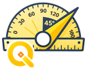
Bearing Protractor is a must-have interactive floating tool for QGIS users, particularly in the Telecommunications, RF Engineering, and GIS planning sectors. It provides an on-screen, draggable protractor overlay designed to speed up cell planning and azimuth audits. Key features include:
* Dynamic Multiple Bearings: Create and drag multiple sector antennas (needles) to simulate coverage direction and beamwidth.
* Real-Time Distance Tracking: Automatically calculates real-world distances (Meters/Km) dynamically based on the map canvas CRS and scale.
* Manual Measurement Ruler: Double-click to draw a temporary line to instantly check the azimuth and distance to neighbor sites.
* Cell Footprint Generation: Export current sector configurations as physical polygon vector layers (Cell_Footprint) directly to the map canvas.
* 1-Click Data Export: Instantly copy sector data (Azimuth, Beamwidth, Distance) to the clipboard in tabular format for easy pasting into spreadsheets or reports.
* Persistent Settings: All visual customizations (ring size, colors, fonts, sector counts) are automatically saved across QGIS sessions.
* Bilingual Support & Clean UI: Seamlessly switch between English and Indonesian, featuring an unobtrusive, transparent interface that doesn't block map visibility.
Whether you are verifying physical tuning, doing site audits, or planning new macro cells, this tool replaces traditional static measurement plugins with a fluid, visual experience.


