
PAT - Precision Agriculture Tools
Plugin ID: 1631
A collection of tools for processing precision agriculture data.
(62) votes
Download latest
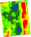
PAT is a QGIS plugin for tools required for processing and analysing precision agriculture data. It includes tools for data cleaning and map interpolation to create TIFF's from high spatial density on-the-go sensor data such as yield monitor or EM38 soil sensor data. There are also tools for analysis of remotely sensed imagery and for the clustering of multiple datasets.
.
This is a Windows only plugin, This plugin requires the installation of the following Python libraries: pyprecag, fiona, and rasterio. Full installation instructions are provided in the manual available at: https://github.com/CSIRO-Precision-Agriculture/PAT_QGIS_Plugin/blob/master/pat/PAT_User_Manual.pdf
.
Developed by the CSIRO Precision Agriculture Team, this project is supported by Wine Australia through funding from the Australian Government Department of Agriculture as part of its Rural R&D for Profit program.


