
Batch Hillshader
Plugin ID: 1380
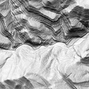
Plugin to generate a three light exposure hillshade (shaded relief by combining three light exposures)
(55) votes
This plugin generates a three light exposure hillshade (shaded relief by combining three light exposures) using
as input LiDAR classified data (ASPRS classification / *.las format) or a Digital Terrain Model (DTM) in
raster format (GEOTiff / ASCII). The three light exposures combining method is based in Gantenbein (2012): <(http://pubs.usgs.gov/of/2012/1171/)>
You can use LasPy Library to process LiDAR data (ASPRS las format). From version 2.3.0 user can generates a terrain hillshade and a surfaces hillshade (only with LasPy processing mode). The surfaces hillshade is generated using only the first LiDAR returns.
For more information see readme.md at plugin folder (see Installed version at the end)
2.4.4 : Updated for LasPy versions 1.x and 2.x. Fixed for numpy versions >= 1.24
2.4.3 : Fix import gdalconst import error in QGIS >=3.22
2.4.2 : Process with zipped LiDAR files is not available. Only process unzipped LiDAR files
2.4.1 : ModuleNotFoundError due LASPy Library -> LasPyNotFoundError
2.4.0 : Deleted external dependencies (FUSION and LASTools). Process with zipped LiDAR files is available (LASzip)
2.3.0 : Added option to generate a terrain hillshade and a surface hillshade at LasPy mode


