QGIS GeoPackage
Common_startingPoint V01

- Name
- Common_startingPoint V01
- Description
Built as a starting point for any new project with ready made project and layers settings and easy to use tools and functions for advanced analysis:
** Enabling of macros is needed for tools to work
** DEM Layer of the area is also needed for most tools to functionVirtual layers- draft&tools:
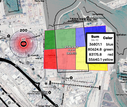
Use the Point, Line and Poly layer for drafts or on-the-fly analysis tools- Use Points to easily measure radius and get a viewshed
- Lines to calculate buffer, distance & slope percentage and line-section (using mapTip)
- Polygons show polygon measures, intersection areas with other layer and grouping those areas by their specified field value (using mapTip)
mapTip and Layouts:
- Use [% eval( @Feat2Html ) %] using mapTip on any layer to get feature attributes on you mapTip
- [% eval_template(@CSS) %] in html labels to get a unified CSS settings for your project
This project was made to share tools which were the most useful for me when working on my projects.
For better management of updates and versions to come I've started this github you're welcome to follow
For any questions, bug reports and any comment or improvements suggestion, please write me at
[email protected].- Use Points to easily measure radius and get a viewshed
- Uploaded Date
- 04 November 2024
- Approved Date
- 28 November 2024
- Modified Date
- 28 November 2024
- Creator
- Sarig
- GeoPackage File

This GeoPackage is made available under the CC-0 license.
